Black Knowe

Hill, Mountain in Northumberland

England

Black Knowe

Looking down the Fulhope Burn With plenty of sheep scattered across the moor.
The Cheviot Hills in the distance.
Looking down the Fulhope Burn Credit: Russel Wills

Black Knowe is a prominent hill located in the county of Northumberland, England. Standing at an elevation of approximately 446 meters (1,463 feet), it is considered one of the highest points in the region. The hill is situated in the northern part of Northumberland, near the village of Ingram, within the Northumberland National Park.

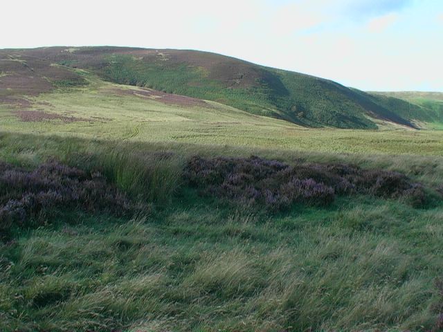
Black Knowe is characterized by its rugged and rocky terrain, covered in heather and grasses that create a picturesque landscape. It forms part of the Cheviot Hills, a range that straddles the border between England and Scotland. The hill offers breathtaking panoramic views of the surrounding countryside, including the Cheviot Hills and the picturesque Ingram Valley.

The area surrounding Black Knowe is rich in wildlife, with several species of birds, such as curlews and skylarks, being commonly spotted. The heather-covered slopes provide a habitat for various plant species, including bilberry and crowberry. The hill is also home to a number of archaeological sites, including the remains of ancient settlements and burial mounds, which are testament to the area's rich history.

Black Knowe offers a range of outdoor activities for visitors to enjoy, including hiking, hillwalking, and birdwatching. Several trails and footpaths crisscross the hill, allowing visitors to explore its natural beauty at their own pace. The hill's proximity to other attractions within the Northumberland National Park, such as the nearby Ingram Valley and the Cheviot Hills, make it a popular destination for nature enthusiasts and hikers alike.

If you have any feedback on the listing, please let us know in the comments section below.

Black Knowe Images

Images are sourced within 2km of 55.370495/-2.2757075 or Grid Reference NT8208. Thanks to Geograph Open Source API. All images are credited.

Looking down the Fulhope Burn With plenty of sheep scattered across the moor.
The Cheviot Hills in the distance.
Looking down the Fulhope Burn
With plenty of sheep scattered across the moor. The Cheviot Hills in the distance.
Saddlers Knowe Part of the northern boundary of Ministry of Defence land at Otterburn Camp
Saddlers Knowe
Part of the northern boundary of Ministry of Defence land at Otterburn Camp
Ridlees Road Ridlees Road crossing Graham's Cleugh.
Ridlees Road
Ridlees Road crossing Graham's Cleugh.
Woolbist Law View of Woolbist Law seen from Ridlees Road.
Woolbist Law
View of Woolbist Law seen from Ridlees Road.
Mixed plantation on Hog Knowe of Deerbush Hill The largest tree in mid-photo caught my eye from miles away as a lone Scots Pine but it turned out a disappointing plane tree.
Mixed plantation on Hog Knowe of Deerbush Hill
The largest tree in mid-photo caught my eye from miles away as a lone Scots Pine but it turned out a disappointing plane tree.
Woolbist Law ploughed by mortar fire Looks as if giant wild boar have been at it!
Woolbist Law ploughed by mortar fire
Looks as if giant wild boar have been at it!
Looking south down Graham's Cleugh near Ridlees Hope
Barrow on Black Knowe Sitting like an island in the wet boggy ground just south-south-east of Black Knowe I think this is a kaim. The photo was taken from a more complicated mound similarly dry and sandy on wet ground.
Barrow on Black Knowe
Sitting like an island in the wet boggy ground just south-south-east of Black Knowe I think this is a kaim. The photo was taken from a more complicated mound similarly dry and sandy on wet ground.
Reedy course of Lucking Burn negotiating Dunnies Hags north-west of Woolbist Law
Ravens Cleugh on Thirl Moor
Fence junction on small top north of Black Knowe Ravens Cleugh in the back-drop.
Fence junction on small top north of Black Knowe
Ravens Cleugh in the back-drop.
Sheep-handling facility on west-south-west ridge of Bell Hill
Looking along fence-line to open moor beyond Dumbhope Burn
Boggy track to Hog Knowe
Rough grasses on Hog Knowe Very demoralising walking conditions - and very tiring even in summer weather.
Rough grasses on Hog Knowe
Very demoralising walking conditions - and very tiring even in summer weather.
Trackside shell-hole on Hog Knowe
Moorland looking towards Deerbush Hill
Plantation, dyke and fence on Hog Knowe
Show me another place!

Black Knowe is located at Grid Ref: NT8208 (Lat: 55.370495, Lng: -2.2757075)

Unitary Authority: Northumberland

Police Authority: Northumbria

What 3 Words

///pelting.strut.snowstorm. Near Rochester, Northumberland

Nearby Locations

Black Knowe

Related Wikis

Featherwood Roman Camps

Featherwood Roman Camps are neighbouring archaeological sites in Northumberland, England, 1 mile (1.6 km) north of Featherwood and about 3 miles (5 km...

Chew Green

Chew Green is the site of the ancient Roman encampment, commonly but erroneously called Ad Fines (Latin: The Limits) on the 1885-1900 edition of the Ordnance...

Barrow Burn

Barrowburn is a hamlet in Upper Coquetdale in the county of Northumberland, England. It comprises a working farm with associated buildings and two holiday...

Barrow Burn Meadows

Barrow Burn Meadows is a Site of Special Scientific Interest (SSSI) in north Northumberland, England. The site is a species-rich hay meadow of a sort now...

Nearby Amenities

Located within 500m of 55.370495,-2.2757075
Black Knowe
Place: locality
Lat/Long: 55.3701725/-2.2746192
The data included in this document is from www.openstreetmap.org. The data is made available under ODbL.

Have you been to Black Knowe?

Leave your review of Black Knowe below (or comments, questions and feedback).