Leonard's Hill
Hill, Mountain in Northumberland
England
Leonard's Hill

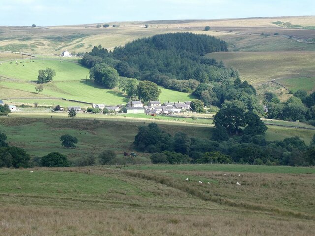
Leonard's Hill is a prominent hill located in Northumberland, England. It is situated in the northern part of the county, near the small village of Harbottle. With an elevation of approximately 342 meters (1,122 feet), Leonard's Hill is a notable feature in the Northumberland National Park.
The hill offers breathtaking panoramic views of the surrounding countryside, including the Cheviot Hills to the north and the Simonside Hills to the east. On clear days, visitors can even catch a glimpse of the North Sea in the distance. The rugged and unspoiled nature of the landscape makes Leonard's Hill a popular destination for hikers, nature enthusiasts, and photographers.
The ascent to the summit of Leonard's Hill can be challenging but rewarding, with a variety of walking routes available to suit different abilities. The hill is largely covered in heather and grass, providing a habitat for a range of wildlife, including birds such as curlews and skylarks.
At the top of Leonard's Hill, there is a trig point, which serves as a marker for surveying purposes. This point offers an excellent vantage point to take in the stunning scenery and appreciate the natural beauty of Northumberland. The hill is easily accessible from nearby Harbottle, with parking available for visitors.
Overall, Leonard's Hill is a hidden gem in Northumberland, offering a chance to immerse oneself in the wild beauty of the region and enjoy unparalleled views of the Northumberland National Park.
If you have any feedback on the listing, please let us know in the comments section below.
Leonard's Hill Images
Images are sourced within 2km of 55.187825/-2.3086035 or Grid Reference NY8088. Thanks to Geograph Open Source API. All images are credited.


Leonard's Hill is located at Grid Ref: NY8088 (Lat: 55.187825, Lng: -2.3086035)
Unitary Authority: Northumberland
Police Authority: Northumbria
What 3 Words
///civic.snowy.informs. Near Bellingham, Northumberland
Nearby Locations
Related Wikis

Charlton, Northumberland
Charlton is a village in Northumberland, England. It is about 1.5 miles (2.4 km) to the northwest of Bellingham, on the River North Tyne. == Governance... ==
Tarset
Tarset is a civil parish in Northumberland, England, created in 1955 from parts of Bellingham, Tarset West and Thorneyburn parishes. It is 4 miles (6 km...

Tarset Castle
Tarset Castle is a ruin near Tarset in Northumberland. == History == A licence to crenellate was granted to John Comyn in 1267, and the castle was built...
Tarset railway station
Tarset railway station served the civil parish of Tarset, Northumberland, England from 1862 to 1958 on the Border Counties Railway. == History == The station...
Nearby Amenities
Located within 500m of 55.187825,-2.3086035Have you been to Leonard's Hill?
Leave your review of Leonard's Hill below (or comments, questions and feedback).