Viewie Knowe

Hill, Mountain in Northumberland

England

Viewie Knowe

Forest operations ahead A long length of this forestry road running from the ford below Ridley Shiel through to Blakehopeburnhaugh is a permitted bridleway. It forms part of the Border County Ride, a 160-kilometre circular bridleway route. The route is not signposted and there is little evidence that it is actively in use for its intended purpose by horse-riders.
Forest operations ahead Credit: Oliver Dixon

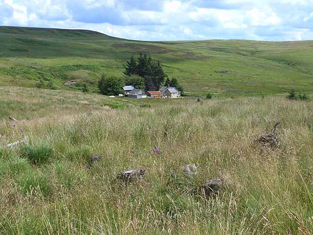
Viewie Knowe is a prominent hill located in Northumberland, England. Situated in the northern part of the county, it forms part of the Cheviot Hills, a range known for its picturesque landscapes and scenic beauty. Viewie Knowe stands at an elevation of approximately 516 meters (1,693 feet) above sea level, making it one of the highest points in the area.

The hill offers breathtaking panoramic views of the surrounding countryside, including the rolling hills, deep valleys, and lush greenery that characterizes this region. On clear days, it is possible to see as far as the North Sea and the Scottish border, adding to the appeal of this natural landmark.

Viewie Knowe is a popular destination for hikers, nature enthusiasts, and outdoor adventurers. There are several well-marked trails that lead to the summit, catering to different levels of difficulty and ensuring that visitors of all abilities can enjoy the stunning vistas. The area is also home to diverse wildlife, including birds of prey, red squirrels, and various species of flora and fauna.

Aside from its natural beauty, Viewie Knowe holds historical significance too. The surrounding area is dotted with remnants of ancient settlements and archaeological sites, offering a glimpse into the region's rich past.

Overall, Viewie Knowe is a captivating destination that showcases the beauty of Northumberland's countryside. Whether visitors are seeking a challenging hike or simply a peaceful escape into nature, this hill is sure to provide an unforgettable experience.

If you have any feedback on the listing, please let us know in the comments section below.

Viewie Knowe Images

Images are sourced within 2km of 55.234682/-2.3306659 or Grid Reference NY7993. Thanks to Geograph Open Source API. All images are credited.

Forest operations ahead A long length of this forestry road running from the ford below Ridley Shiel through to Blakehopeburnhaugh is a permitted bridleway. It forms part of the Border County Ride, a 160-kilometre circular bridleway route. The route is not signposted and there is little evidence that it is actively in use for its intended purpose by horse-riders.
Forest operations ahead
A long length of this forestry road running from the ford below Ridley Shiel through to Blakehopeburnhaugh is a permitted bridleway. It forms part of the Border County Ride, a 160-kilometre circular bridleway route. The route is not signposted and there is little evidence that it is actively in use for its intended purpose by horse-riders.
Ridley Shiel Looking from an area of clearfell on the edge of the forest towards the valley of the Black Burn and Ridley Shiel farm <a href="https://www.geograph.org.uk/gridref/NY7892">NY7892</a>.
Ridley Shiel
Looking from an area of clearfell on the edge of the forest towards the valley of the Black Burn and Ridley Shiel farm NY7892.
Log piles near Ridley Shiel Forest operations are taking place nearby. A long length of this forestry road running from the ford below Ridley Shiel through to Blakehopeburnhaugh is a permitted bridleway. It forms part of the Border County Ride, a 160-kilometre circular bridleway route. The route is not signposted and there is little evidence that it is actively in use for its intended purpose by horse-riders.
Log piles near Ridley Shiel
Forest operations are taking place nearby. A long length of this forestry road running from the ford below Ridley Shiel through to Blakehopeburnhaugh is a permitted bridleway. It forms part of the Border County Ride, a 160-kilometre circular bridleway route. The route is not signposted and there is little evidence that it is actively in use for its intended purpose by horse-riders.
Forest clearing at Dunn's Sike Some broadleaf trees provide relief from the endless conifers.
Forest clearing at Dunn's Sike
Some broadleaf trees provide relief from the endless conifers.
Windblow near Dunn's Sike Large areas of forest are regularly destroyed by strong winds. Once one of the shallow-rooted, closely-spaced conifers blows over, they all go.
Windblow near Dunn's Sike
Large areas of forest are regularly destroyed by strong winds. Once one of the shallow-rooted, closely-spaced conifers blows over, they all go.
Bothy at Blackburnhead A notice announces that the bothy is closed - and has been for at least four years now.
Bothy at Blackburnhead
A notice announces that the bothy is closed - and has been for at least four years now.
Head of the valley of the Black Burn The floor of the valley is grassland, but has been invaded by conifers from the adjoining plantations.
Head of the valley of the Black Burn
The floor of the valley is grassland, but has been invaded by conifers from the adjoining plantations.
Grassy clearing at the head of the Black Burn
Ford at Ridley Shiel This ford on the Black Burn is found at Ridley Shiel.
<span class="nowrap"><a title="https://youtu.be/wjRF1gmR6n4" rel="nofollow ugc noopener" href="https://youtu.be/wjRF1gmR6n4">Link</a><img style="margin-left:2px;" alt="External link" title="External link - shift click to open in new window" src="https://s1.geograph.org.uk/img/external.png" width="10" height="10"/></span>
Ford at Ridley Shiel
This ford on the Black Burn is found at Ridley Shiel. LinkExternal link
Switchbank road to Gibshiel The valley of the Tarret Burn to the left. Redesdale Forest on the horizon.
Switchbank road to Gibshiel
The valley of the Tarret Burn to the left. Redesdale Forest on the horizon.
Valley of the Tarret Burn A sheepfold can be seen in the floor of the valley. The edge of Redesdale Forest beyond.
Valley of the Tarret Burn
A sheepfold can be seen in the floor of the valley. The edge of Redesdale Forest beyond.
Two diminutive black rams at Gibshiel Hebridean breed (identification courtesy of Adrian Cable and his wife).
Two diminutive black rams at Gibshiel
Hebridean breed (identification courtesy of Adrian Cable and his wife).
Gibshiel Farm Remote farm on the edge of Redesdale Forest.
Gibshiel Farm
Remote farm on the edge of Redesdale Forest.
Gated road to Gibshiel Redesdale Forest on the skyline.
Gated road to Gibshiel
Redesdale Forest on the skyline.
New planting in Gibshiel Plantation Tuley tubes protect the young saplings in this cleared area of forest.
New planting in Gibshiel Plantation
Tuley tubes protect the young saplings in this cleared area of forest.
New planting in Gibshiel Plantation Tuley tubes protect the young saplings in this cleared area. The forestry road is part of an old road which runs all the way from Bellingham to Byrness.
New planting in Gibshiel Plantation
Tuley tubes protect the young saplings in this cleared area. The forestry road is part of an old road which runs all the way from Bellingham to Byrness.
Moorland farmstead A very remote cottage surrounded by lovely scenery.
Moorland farmstead
A very remote cottage surrounded by lovely scenery.
Ford, Ridley Shiel
Ford, Ridley Shiel
Show me another place!

Viewie Knowe is located at Grid Ref: NY7993 (Lat: 55.234682, Lng: -2.3306659)

Unitary Authority: Northumberland

Police Authority: Northumbria

What 3 Words

///symphonic.bond.shelters. Near Rochester, Northumberland

Nearby Locations

Viewie Knowe

Related Wikis

Border Moors and Forests

Border Moors and Forests NCA is an upland plateau region in Northern England between the North East and North West regions, and touching the Anglo-Scottish...

Black Middens Bastle House

Black Middens Bastle House lies about 7 miles (11 km) northwest of Bellingham, Northumberland. It is a two-storey fortified stone farmhouse from the 16th...

Kielderhead and Emblehope Moors

Kielderhead and Emblehope Moors are contiguous areas of moorland in northern Northumberland, England. A section of Kielderhead Moor is part of neighbouring...

Thorneyburn

Thorneyburn is a village and former civil parish, now in the parish of Tarset, in Northumberland, England, to the northwest of Bellingham. In 1951 the...

Have you been to Viewie Knowe?

Leave your review of Viewie Knowe below (or comments, questions and feedback).