Bartle Hill

Hill, Mountain in Berwickshire

Scotland

Bartle Hill

Layby  at  Puncheon  Bridge  on  A697 Temporary traffic lights on main road on the line of new overhead power cables from Eccles sub station through to Galashiels
Layby at Puncheon Bridge on A697 Credit: Martin Dawes

Bartle Hill is a prominent hill located in the Scottish Borders region of Berwickshire, United Kingdom. Rising to an elevation of approximately 217 meters (712 feet), it is known for its picturesque beauty and breathtaking panoramic views of the surrounding countryside.

Situated in the eastern part of Berwickshire, Bartle Hill is characterized by its gently sloping terrain, covered in lush green grass and scattered with heather and wildflowers. The hill offers a variety of walking routes, making it a popular destination for hikers and nature enthusiasts. The ascent to the summit is relatively easy, making it accessible to people of all fitness levels.

From the top of Bartle Hill, one can enjoy unobstructed vistas of the rolling hills and valleys that dominate the landscape of Berwickshire. On a clear day, the view extends as far as the North Sea in the east, while the Cheviot Hills in Northumberland can be seen to the south.

Bartle Hill also holds historical significance, as it is believed to have been a site of Iron Age settlements. Archaeological evidence suggests that the hill may have been used as a defensive position during ancient times.

Overall, Bartle Hill offers a serene escape into nature, providing visitors with an opportunity to admire the beauty of the Berwickshire countryside and immerse themselves in the region's rich history.

If you have any feedback on the listing, please let us know in the comments section below.

Bartle Hill Images

Images are sourced within 2km of 55.658006/-2.3635195 or Grid Reference NT7740. Thanks to Geograph Open Source API. All images are credited.

Layby  at  Puncheon  Bridge  on  A697 Temporary traffic lights on main road on the line of new overhead power cables from Eccles sub station through to Galashiels
Layby at Puncheon Bridge on A697
Temporary traffic lights on main road on the line of new overhead power cables from Eccles sub station through to Galashiels
Bankhead  Farm  and  cottages  alongside  A697 The farm sign says Eccles Bankhead, Eccles being the village about half a mile SW
Bankhead Farm and cottages alongside A697
The farm sign says Eccles Bankhead, Eccles being the village about half a mile SW
Approaching  offset  crossroads  on  A697
Approaching offset crossroads on A697
Eccles Church The present building dates back to 1774 when it replaced a mediaeval church dedicated to St Andrew. A local told me services are no longer held in the church but the churchyard is still beautifully maintained.
Eccles Church
The present building dates back to 1774 when it replaced a mediaeval church dedicated to St Andrew. A local told me services are no longer held in the church but the churchyard is still beautifully maintained.
The organ at Eccles Church A local told me services are no longer held in the church.
The organ at Eccles Church
A local told me services are no longer held in the church.
A weathered headstone at Eccles Churchyard
A stained glass window on the southeast wall of Eccles Church The names of the fallen in two World Wars are on the lower part of the window.
A stained glass window on the southeast wall of Eccles Church
The names of the fallen in two World Wars are on the lower part of the window.
A colourful round window at Eccles Church There two of these widow types on the southeast wall. This was viewed from the gallery.
A colourful round window at Eccles Church
There two of these widow types on the southeast wall. This was viewed from the gallery.
A stained glass window at Eccles Church The window on the southeast wall displays the names of the fallen in two World Wars. For a full view of the window, see <a href="https://www.geograph.org.uk/photo/7472302">NT7641 : A stained glass window on the southeast wall of Eccles Church</a>.
A stained glass window at Eccles Church
The window on the southeast wall displays the names of the fallen in two World Wars. For a full view of the window, see NT7641 : A stained glass window on the southeast wall of Eccles Church.
Inside Eccles Church This is a view towards the gallery. The present building dates back to 1774 when it replaced a mediaeval church dedicated to St Andrew. Services are no longer held in the church but the churchyard is still well maintained.
Inside Eccles Church
This is a view towards the gallery. The present building dates back to 1774 when it replaced a mediaeval church dedicated to St Andrew. Services are no longer held in the church but the churchyard is still well maintained.
Collapsing bale stack, Eccles
Eccles to Birgham road Drumlin country.
Eccles to Birgham road
Drumlin country.
Crossing a drumlin Eccles to Birgham road.
Crossing a drumlin
Eccles to Birgham road.
Drainage near Eccles Field drain between Brae Dunstan and Bartle Hill, a pair of drumlins.
Drainage near Eccles
Field drain between Brae Dunstan and Bartle Hill, a pair of drumlins.
Road towards Fernyrig Farm As Sustrans have all but demolished their network by introducing pointless gaps and taping over their signs, this may or may not still be part of their Route 1.

Does anyone understand the point of Sustrans?
Road towards Fernyrig Farm
As Sustrans have all but demolished their network by introducing pointless gaps and taping over their signs, this may or may not still be part of their Route 1. Does anyone understand the point of Sustrans?
Hedge-lined minor road heading towards Lochton Looking north-westward.
Hedge-lined minor road heading towards Lochton
Looking north-westward.
Minor road approaching Lochton Farm Cottages Looking north-westward.
Minor road approaching Lochton Farm Cottages
Looking north-westward.
Track and footpath leading to Birgham Wood Looking north-eastward.
Track and footpath leading to Birgham Wood
Looking north-eastward.
Show me another place!

Bartle Hill is located at Grid Ref: NT7740 (Lat: 55.658006, Lng: -2.3635195)

Unitary Authority: The Scottish Borders

Police Authority: The Lothians and Scottish Borders

What 3 Words

///alcove.scratches.grafted. Near Coldstream, Scottish Borders

Related Wikis

Eccles, Scottish Borders

Eccles (Scottish Gaelic: An Eaglais. Brythonic/Welsh: Eglwys) is a village and agricultural parish near Kelso in Berwickshire in the Scottish Borders area...
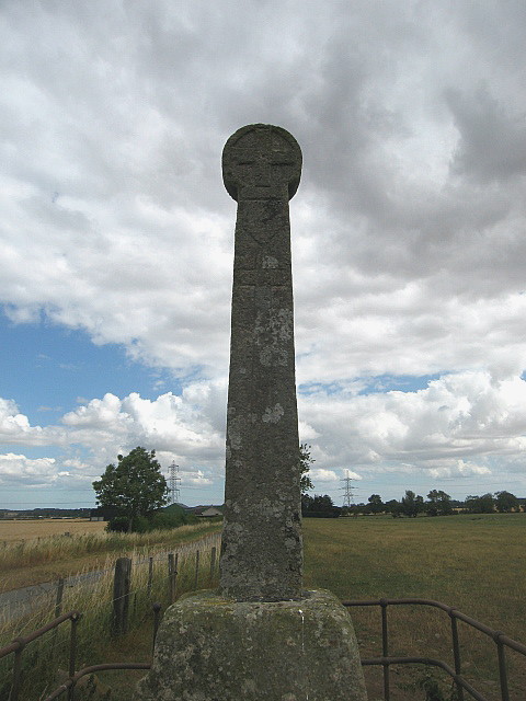
Crosshall cross

The Crosshall Cross is a cross at Crosshall Farm, Eccles, in the Scottish Borders area of Scotland, in historic Berwickshire. The cross is situated near...

Birgham

Birgham is a village in Berwickshire, parish of Eccles in the Scottish Borders area of Scotland, near Coldstream and the River Tweed, on the A698....

Eden Water

Eden Water is a tributary of the River Tweed in the Scottish Borders of Scotland. "Water" is the Lowland Scots term for a small river. The Eden Burn rises...

Leitholm

Leitholm (Scots: Leithowm) is a village in the Scottish Borders area of Scotland, 4 miles (6.4 km) north-west of Coldstream, in the former county of Berwickshire...

Carham

Carham or Carham on Tweed is a village in Northumberland, England. The village lies on the south side of the River Tweed about 3 miles (5 km) west of Coldstream...

Battle of Carham

The Battle of Carham was fought between the English ruler of Bamburgh and the king of Scotland in alliance with the Cumbrians. The encounter took place...

Carham Hall

Carham Hall is a grade II listed building near Carham in Northumberland, England. The site, on the Scottish border, was previously occupied by a medieval...

Nearby Amenities

Located within 500m of 55.658006,-2.3635195
Eccles Newton
Place: hamlet
Lat/Long: 55.6588083/-2.3559356
Give Way
Direction: forward
Lat/Long: 55.6575692/-2.3593735
Brae Dunstan
Place: locality
Lat/Long: 55.6614964/-2.3657585
Bartlehill
Place: hamlet
Lat/Long: 55.6565181/-2.3653927
Give Way
Direction: forward
Lat/Long: 55.65882/-2.3616448
Give Way
Direction: backward
Lat/Long: 55.6558667/-2.3573536
Power: pole
Lat/Long: 55.6563356/-2.3701922
Power: pole
Lat/Long: 55.6569454/-2.3692372
Power: pole
Lat/Long: 55.6574877/-2.3684164
Power: pole
Lat/Long: 55.658148/-2.3676639
Power: pole
Lat/Long: 55.6588888/-2.3673143
Power: pole
Lat/Long: 55.6593578/-2.3662484
Power: pole
Lat/Long: 55.65984/-2.3652102
Power: pole
Lat/Long: 55.6603487/-2.3640441
Power: pole
Lat/Long: 55.6609536/-2.3630656
Power: pole
Lat/Long: 55.6614899/-2.3622193
Power: pole
Lat/Long: 55.6577078/-2.3667792
Power: pole
Lat/Long: 55.6572929/-2.3660139
Power: pole
Lat/Long: 55.65878/-2.3563131
Power: pole
Lat/Long: 55.6592874/-2.3574238
Power: pole
Lat/Long: 55.6598587/-2.358688
Power: pole
Lat/Long: 55.6604371/-2.3599521
Power: pole
Lat/Long: 55.6609975/-2.3611608
Power: pole
Lat/Long: 55.6619703/-2.3631178
Power: pole
Lat/Long: 55.6623587/-2.3638299
The data included in this document is from www.openstreetmap.org. The data is made available under ODbL.

Have you been to Bartle Hill?

Leave your review of Bartle Hill below (or comments, questions and feedback).