Broom Hill

Hill, Mountain in Roxburghshire

Scotland

Broom Hill

Fawhope Rig Five TUMP circuit from Upper Hindhope with Smudge. Fawhope Rig, Goshen Hill, Philip Law, Heugh Law and Loddan Hill.
Name: Fawhope Rig
Hill number: 13956
Height: 372m / 1220ft
Parent (Ma/M): 2302  The Cheviot
Section: 28B: The River Tweed to the English Border
County/UA: Scottish Borders (UA)
Class: Tump (300-399m)
Grid ref: NT 74409 09798
Summit feature: no feature: grass
Drop: 43m
Col: 329m  NT737094
Fawhope Rig Credit: Rude Health

Broom Hill is a prominent hill located in the county of Roxburghshire, Scotland. It is situated in the southern region of the country, near the town of Hawick. With an elevation of approximately 290 meters (951 feet), it offers breathtaking views of the surrounding landscape.

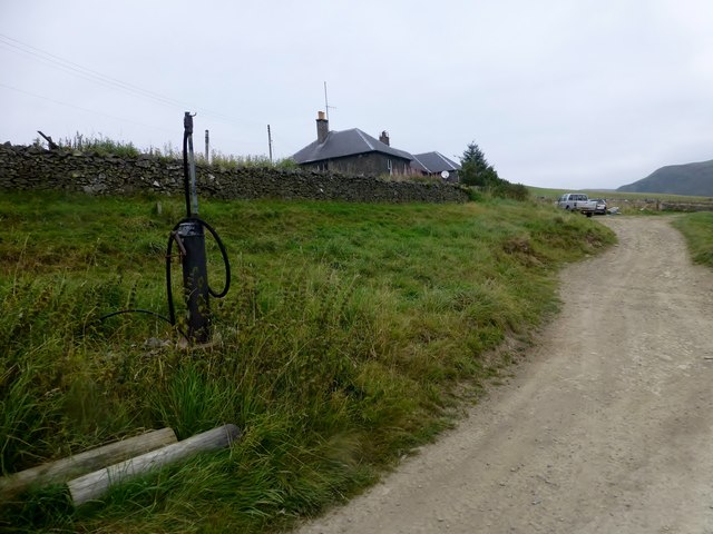
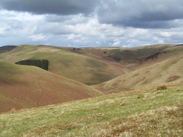
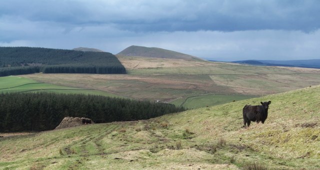
The hill is characterized by its gently sloping sides and is covered in verdant grasslands and heather, providing a picturesque sight, especially during the summer months. Its location in the heart of the Scottish Borders region ensures that Broom Hill is a popular destination for nature enthusiasts, hikers, and photographers.

The summit of Broom Hill is accessible by well-maintained footpaths, allowing visitors to explore the area at their own pace. From the top, one can relish stunning panoramic vistas that stretch across the rolling hills, scenic valleys, and tranquil rivers that define the Roxburghshire countryside. On a clear day, it is even possible to see the distant peaks of the Cheviot Hills and the Northumberland National Park.

Broom Hill also holds historical significance, as it was once home to an Iron Age fort. Archaeological artifacts have been discovered in the vicinity, providing evidence of the hill's ancient past.

Whether it be for a leisurely stroll, a challenging hike, or a moment of tranquility amidst nature, Broom Hill offers a delightful experience for all who visit. Its natural beauty, accessibility, and historical significance make it a must-see destination in Roxburghshire.

If you have any feedback on the listing, please let us know in the comments section below.

Broom Hill Images

Images are sourced within 2km of 55.380721/-2.3851645 or Grid Reference NT7509. Thanks to Geograph Open Source API. All images are credited.

Fawhope Rig Five TUMP circuit from Upper Hindhope with Smudge. Fawhope Rig, Goshen Hill, Philip Law, Heugh Law and Loddan Hill.
Name: Fawhope Rig
Hill number: 13956
Height: 372m / 1220ft
Parent (Ma/M): 2302  The Cheviot
Section: 28B: The River Tweed to the English Border
County/UA: Scottish Borders (UA)
Class: Tump (300-399m)
Grid ref: NT 74409 09798
Summit feature: no feature: grass
Drop: 43m
Col: 329m  NT737094
Fawhope Rig
Five TUMP circuit from Upper Hindhope with Smudge. Fawhope Rig, Goshen Hill, Philip Law, Heugh Law and Loddan Hill. Name: Fawhope Rig Hill number: 13956 Height: 372m / 1220ft Parent (Ma/M): 2302 The Cheviot Section: 28B: The River Tweed to the English Border County/UA: Scottish Borders (UA) Class: Tump (300-399m) Grid ref: NT 74409 09798 Summit feature: no feature: grass Drop: 43m Col: 329m NT737094
Shelter Beside Track An open ended shed that provides shelter for animals beside a farm track near Upper Hindhope.
Shelter Beside Track
An open ended shed that provides shelter for animals beside a farm track near Upper Hindhope.
Diesel Pump Diesel pump beside farm track below farm cottages at Upper Hindhope.
Diesel Pump
Diesel pump beside farm track below farm cottages at Upper Hindhope.
The valley of Hindhope Burn Typical steep sided valley on the Scottish side of the Cheviots. The Hindhope Burn, which is hidden down below, is heading NE at this point, but circles around Hindhope Law to head west and join the beginnings of the Kale Water at Nether Hindhope.
The valley of Hindhope Burn
Typical steep sided valley on the Scottish side of the Cheviots. The Hindhope Burn, which is hidden down below, is heading NE at this point, but circles around Hindhope Law to head west and join the beginnings of the Kale Water at Nether Hindhope.
There may be trouble ahead Not so much caused by the rather frisky cattle, but by the fact that there was a feeding area on the trackside ahead where the whole area had been churned into a sea of grey mud with added cow pats. The shapely hill in the distance is Philip Law 414m.
There may be trouble ahead
Not so much caused by the rather frisky cattle, but by the fact that there was a feeding area on the trackside ahead where the whole area had been churned into a sea of grey mud with added cow pats. The shapely hill in the distance is Philip Law 414m.
Border country from the air The Cheviot Hills are mostly under cloud on the right, Upper Hindhope is at the bottom, to the left of the cloud.
Border country from the air
The Cheviot Hills are mostly under cloud on the right, Upper Hindhope is at the bottom, to the left of the cloud.
Upper Hindhope A traditional stone steading, with arched bays around an inner courtyard.
Upper Hindhope
A traditional stone steading, with arched bays around an inner courtyard.
Sheds at Upper Hindhope Corrugated iron sheds besides the Hawkwillow Burn, a headwater of the Kale Water.
Sheds at Upper Hindhope
Corrugated iron sheds besides the Hawkwillow Burn, a headwater of the Kale Water.
Long Burn A gloomy scene on a dreich wet day at Upper Hindhope.
Long Burn
A gloomy scene on a dreich wet day at Upper Hindhope.
Boggy Land Even from the relatively safe height of the road, you can see how wet the floor of the valley is.
Boggy Land
Even from the relatively safe height of the road, you can see how wet the floor of the valley is.
Hindhope View upstream near the head of the Kale Water.
Hindhope
View upstream near the head of the Kale Water.
Hind Hope
Hind Hope
Whiteside Hill above Hind Hope A linear earthwork crosses the ridge of Whiteside Hill just left (south) of the summit extending to stream valleys on both sides. Old cross-Border tracks pass through two gaps on the sides of the ridge.
<span class="nowrap"><a title="http://canmore.rcahms.gov.uk/en/site/57885/" rel="nofollow ugc noopener" href="http://canmore.rcahms.gov.uk/en/site/57885/">Link</a><img style="margin-left:2px;" alt="External link" title="External link - shift click to open in new window" src="https://s1.geograph.org.uk/img/external.png" width="10" height="10"/></span>
Whiteside Hill above Hind Hope
A linear earthwork crosses the ridge of Whiteside Hill just left (south) of the summit extending to stream valleys on both sides. Old cross-Border tracks pass through two gaps on the sides of the ridge. LinkExternal link
Above Grindstone Burn
Moorland north of Grindstone Burn
Grindstone Burn
Grindstone Burn
Ruined outbuildings, Fawhope One of many farms and dwellings lost to the big forests of the Border.
Ruined outbuildings, Fawhope
One of many farms and dwellings lost to the big forests of the Border.
Road, Fawhope
Road, Fawhope
Show me another place!

Broom Hill is located at Grid Ref: NT7509 (Lat: 55.380721, Lng: -2.3851645)

Unitary Authority: The Scottish Borders

Police Authority: The Lothians and Scottish Borders

What 3 Words

///shoelaces.shapeless.crush. Near Rochester, Northumberland

Nearby Locations

Broom Hill

Related Wikis

Chew Green

Chew Green is the site of the ancient Roman encampment, commonly but erroneously called Ad Fines (Latin: The Limits) on the 1885-1900 edition of the Ordnance...

Pennymuir Roman camps

The Pennymuir Roman camps are situated southeast of Jedburgh in the Scottish Borders area of Scotland, near the Anglo-Scottish border, in the former Roxburghshire...

Ramshope

Ramshope is a hamlet and former civil parish, now in the parish of Rochester in Northumberland, England located in Northumberland National Park. It lies...

Raid of the Redeswire

The Raid of the Redeswire, also known as the Redeswire Fray, was a border skirmish between England and Scotland on 7 July 1575 which took place at Carter...

Carter Bar

Carter Bar is a pass in the Cheviot Hills, on the Anglo-Scottish border. It lies east of Carter Fell at the head of Redesdale, and is crossed by the A68...

Edgerston

Edgerston is a village and an estate about 4 miles (6.4 km) north of the Anglo-Scottish border, and 8 miles (13 km) south of Jedburgh in the Scottish Borders...

Scottish Borders

The Scottish Borders (Scots: the Mairches, lit. 'the Marches'; Scottish Gaelic: Crìochan na h-Alba) is one of 32 council areas of Scotland. It is bordered...

Byrness

Byrness is a village within Rochester civil parish in Northumberland, England. It is approximately 37 miles (60 km) north-west of Newcastle upon Tyne on...

Nearby Amenities

Located within 500m of 55.380721,-2.3851645
Upper Hindhope
Place: hamlet
Lat/Long: 55.3822071/-2.3787531
Power: pole
Lat/Long: 55.3807/-2.3775592
Power: pole
Lat/Long: 55.3802451/-2.3781978
Power: pole
Lat/Long: 55.3797535/-2.3788441
Power: pole
Lat/Long: 55.3793249/-2.3794337
Power: pole
Lat/Long: 55.3788933/-2.3800286
Power: pole
Lat/Long: 55.3784442/-2.3806285
Power: pole
Lat/Long: 55.3780638/-2.3813572
Power: pole
Lat/Long: 55.37772/-2.3819804
Power: pole
Lat/Long: 55.3772504/-2.382861
Power: pole
Lat/Long: 55.3767866/-2.3837159
Power: pole
Lat/Long: 55.376257/-2.3846738
Power: pole
Lat/Long: 55.381057/-2.377778
Power: pole
Lat/Long: 55.3810058/-2.3789728
Power: pole
Lat/Long: 55.3815821/-2.3781154
Power: pole
Lat/Long: 55.3820356/-2.378669
Power: pole
Lat/Long: 55.38259/-2.378996
Power: pole
Lat/Long: 55.3771977/-2.3890564
Power: pole
Lat/Long: 55.3775839/-2.3897285
Power: pole
Lat/Long: 55.3780974/-2.3905937
The data included in this document is from www.openstreetmap.org. The data is made available under ODbL.

Have you been to Broom Hill?

Leave your review of Broom Hill below (or comments, questions and feedback).