Loddan Hill

Hill, Mountain in Roxburghshire

Scotland

Loddan Hill

Fawhope Rig Five TUMP circuit from Upper Hindhope with Smudge. Fawhope Rig, Goshen Hill, Philip Law, Heugh Law and Loddan Hill.
Name: Fawhope Rig
Hill number: 13956
Height: 372m / 1220ft
Parent (Ma/M): 2302  The Cheviot
Section: 28B: The River Tweed to the English Border
County/UA: Scottish Borders (UA)
Class: Tump (300-399m)
Grid ref: NT 74409 09798
Summit feature: no feature: grass
Drop: 43m
Col: 329m  NT737094
Fawhope Rig Credit: Rude Health

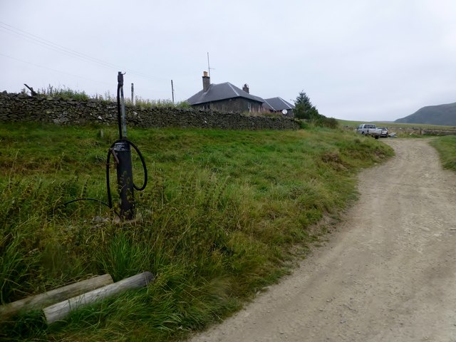
Loddan Hill, located in Roxburghshire, Scotland, is a prominent hill that offers breathtaking views and outdoor recreational opportunities. Rising to an elevation of 320 meters (1050 feet), it is a popular destination among locals and visitors alike.

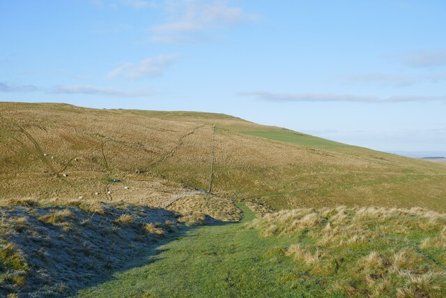
The hill is part of the Southern Uplands, which is known for its rolling hills and scenic beauty. Loddan Hill stands out due to its distinctive shape and the lush greenery that covers its slopes. It is primarily composed of sedimentary rock, which gives it a unique geological character.

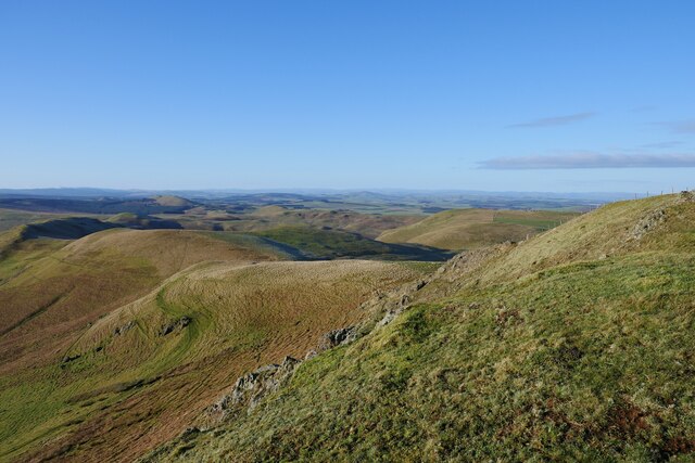
The hill is accessible via several footpaths and trails, making it an ideal spot for hiking and walking enthusiasts. As one ascends the hill, the panoramic views of the surrounding countryside become increasingly spectacular. On clear days, it is possible to see as far as the Cheviot Hills and the Northumberland National Park to the south.

Loddan Hill is also home to a diverse range of flora and fauna. The hillside is covered in heather and wildflowers, attracting a variety of insects and birds. It is not uncommon to spot birds of prey, such as buzzards and kestrels, soaring overhead.

For those seeking tranquility and a connection with nature, Loddan Hill is a peaceful retreat. Its natural beauty and serene atmosphere make it a favored spot for picnicking, photography, and simply enjoying the great outdoors. Whether one is a nature lover or an avid hiker, Loddan Hill is a must-visit destination in Roxburghshire.

If you have any feedback on the listing, please let us know in the comments section below.

Loddan Hill Images

Images are sourced within 2km of 55.393107/-2.3868005 or Grid Reference NT7511. Thanks to Geograph Open Source API. All images are credited.

Fawhope Rig Five TUMP circuit from Upper Hindhope with Smudge. Fawhope Rig, Goshen Hill, Philip Law, Heugh Law and Loddan Hill.
Name: Fawhope Rig
Hill number: 13956
Height: 372m / 1220ft
Parent (Ma/M): 2302  The Cheviot
Section: 28B: The River Tweed to the English Border
County/UA: Scottish Borders (UA)
Class: Tump (300-399m)
Grid ref: NT 74409 09798
Summit feature: no feature: grass
Drop: 43m
Col: 329m  NT737094
Fawhope Rig
Five TUMP circuit from Upper Hindhope with Smudge. Fawhope Rig, Goshen Hill, Philip Law, Heugh Law and Loddan Hill. Name: Fawhope Rig Hill number: 13956 Height: 372m / 1220ft Parent (Ma/M): 2302 The Cheviot Section: 28B: The River Tweed to the English Border County/UA: Scottish Borders (UA) Class: Tump (300-399m) Grid ref: NT 74409 09798 Summit feature: no feature: grass Drop: 43m Col: 329m NT737094
Shelter Beside Track An open ended shed that provides shelter for animals beside a farm track near Upper Hindhope.
Shelter Beside Track
An open ended shed that provides shelter for animals beside a farm track near Upper Hindhope.
Diesel Pump Diesel pump beside farm track below farm cottages at Upper Hindhope.
Diesel Pump
Diesel pump beside farm track below farm cottages at Upper Hindhope.
Border country from the air The Cheviot Hills are mostly under cloud on the right, Upper Hindhope is at the bottom, to the left of the cloud.
Border country from the air
The Cheviot Hills are mostly under cloud on the right, Upper Hindhope is at the bottom, to the left of the cloud.
Upper Hindhope A traditional stone steading, with arched bays around an inner courtyard.
Upper Hindhope
A traditional stone steading, with arched bays around an inner courtyard.
Sheds at Upper Hindhope Corrugated iron sheds besides the Hawkwillow Burn, a headwater of the Kale Water.
Sheds at Upper Hindhope
Corrugated iron sheds besides the Hawkwillow Burn, a headwater of the Kale Water.
Long Burn A gloomy scene on a dreich wet day at Upper Hindhope.
Long Burn
A gloomy scene on a dreich wet day at Upper Hindhope.
Boggy Land Even from the relatively safe height of the road, you can see how wet the floor of the valley is.
Boggy Land
Even from the relatively safe height of the road, you can see how wet the floor of the valley is.
Hindhope View upstream near the head of the Kale Water.
Hindhope
View upstream near the head of the Kale Water.
On Dere Street looking back to Woden Law The route of Dere Street with a view back to Woden Law.  The remains of earthworks labelled on the 1:25k map are evident to the left of shot.
On Dere Street looking back to Woden Law
The route of Dere Street with a view back to Woden Law. The remains of earthworks labelled on the 1:25k map are evident to the left of shot.
A view to Hunthall Hill and Hindhope Hill A view from Blackhall Hill towards Hunthall Hill and Hindhope Hill on a crisp winter afternoon.
A view to Hunthall Hill and Hindhope Hill
A view from Blackhall Hill towards Hunthall Hill and Hindhope Hill on a crisp winter afternoon.
Plantation at Corse Slack From the track from Whiteside Hill to Nether Hindhope
Plantation at Corse Slack
From the track from Whiteside Hill to Nether Hindhope
Farm buildings at Upper Hindhope
Upper Hindhope Farm in the remote Hindhope valley just north of the Border.
Upper Hindhope
Farm in the remote Hindhope valley just north of the Border.
Valley of the Long Burn Assorted agricultural features in the floor of the valley. Upper Hindhope Farm <a href="https://www.geograph.org.uk/gridref/NT7609">NT7609</a> lies to the right of the plantation.
Valley of the Long Burn
Assorted agricultural features in the floor of the valley. Upper Hindhope Farm NT7609 lies to the right of the plantation.
Ford on the Long Burn This ford on the Long Burn looks innocuous from a distance, but under winter conditions is very deep and swift-flowing. Just negotiable by quad bike, but a major obstacle on foot. Upper Hindhope farm <a href="https://www.geograph.org.uk/gridref/NT7609">NT7609</a> stands at the foot of the plantation in the distance.
Ford on the Long Burn
This ford on the Long Burn looks innocuous from a distance, but under winter conditions is very deep and swift-flowing. Just negotiable by quad bike, but a major obstacle on foot. Upper Hindhope farm NT7609 stands at the foot of the plantation in the distance.
Ford on the Long Burn One of two closely spaced fords on the Long Burn (see also <a href="https://www.geograph.org.uk/photo/652662">NT7509 : Ford on the Long Burn</a>). A formidable obstacle under winter conditions.
Ford on the Long Burn
One of two closely spaced fords on the Long Burn (see also NT7509 : Ford on the Long Burn). A formidable obstacle under winter conditions.
Cattle in the Hindhope valley The shepherd's cottage above Upper Hindhope in the middle distance, with Leithope Forest beyond.
Cattle in the Hindhope valley
The shepherd's cottage above Upper Hindhope in the middle distance, with Leithope Forest beyond.
Show me another place!

Loddan Hill is located at Grid Ref: NT7511 (Lat: 55.393107, Lng: -2.3868005)

Unitary Authority: The Scottish Borders

Police Authority: The Lothians and Scottish Borders

What 3 Words

///caressing.health.latitudes. Near Jedburgh, Scottish Borders

Nearby Locations

Loddan Hill

Related Wikis

Pennymuir Roman camps

The Pennymuir Roman camps are situated southeast of Jedburgh in the Scottish Borders area of Scotland, near the Anglo-Scottish border, in the former Roxburghshire...

Chew Green

Chew Green is the site of the ancient Roman encampment, commonly but erroneously called Ad Fines (Latin: The Limits) on the 1885-1900 edition of the Ordnance...

Edgerston

Edgerston is a village and an estate about 4 miles (6.4 km) north of the Anglo-Scottish border, and 8 miles (13 km) south of Jedburgh in the Scottish Borders...

Ramshope

Ramshope is a hamlet and former civil parish, now in the parish of Rochester in Northumberland, England located in Northumberland National Park. It lies...

Nearby Amenities

Located within 500m of 55.393107,-2.3868005
Loddan Hill
Natural: peak
Lat/Long: 55.3928718/-2.3853008
The data included in this document is from www.openstreetmap.org. The data is made available under ODbL.

Have you been to Loddan Hill?

Leave your review of Loddan Hill below (or comments, questions and feedback).