Wormer Law

Hill, Mountain in Berwickshire

Scotland

Wormer Law

Eccles Church The present building dates back to 1774 when it replaced a mediaeval church dedicated to St Andrew. A local told me services are no longer held in the church but the churchyard is still beautifully maintained.
Eccles Church Credit: Walter Baxter

Wormer Law is a prominent hill located in the county of Berwickshire, Scotland. Rising to an elevation of approximately 377 meters (1,237 feet), it forms part of the Lammermuir Hills range and is situated within the Southern Uplands. The hill is positioned about 7 kilometers (4.3 miles) northeast of the town of Duns.

Wormer Law offers breathtaking panoramic views of the surrounding countryside, including the nearby Duns Law and the rolling landscape of Berwickshire. The hill is covered in heather and grass, providing a picturesque setting for hikers and nature enthusiasts. Its distinctive shape and prominent position make it easily identifiable from various vantage points in the region.

The ascent to the summit of Wormer Law is relatively moderate, making it accessible to both experienced walkers and casual visitors. The hill is a popular destination for outdoor activities such as hillwalking, birdwatching, and photography. Its location within the Southern Uplands makes it an excellent spot for wildlife observation, with sightings of various bird species, including raptors, being common.

Wormer Law holds historical significance as well. It is believed to have been a site of ancient settlements, with remnants of prehistoric structures found in the area. Additionally, the hill's strategic position made it a likely vantage point during conflicts and battles that occurred in the region throughout history.

Overall, Wormer Law in Berwickshire offers visitors a chance to immerse themselves in the natural beauty and history of the Scottish countryside, providing a rewarding experience for those who venture to its summit.

If you have any feedback on the listing, please let us know in the comments section below.

Wormer Law Images

Images are sourced within 2km of 55.657683/-2.3896611 or Grid Reference NT7540. Thanks to Geograph Open Source API. All images are credited.

Eccles Church The present building dates back to 1774 when it replaced a mediaeval church dedicated to St Andrew. A local told me services are no longer held in the church but the churchyard is still beautifully maintained.
Eccles Church
The present building dates back to 1774 when it replaced a mediaeval church dedicated to St Andrew. A local told me services are no longer held in the church but the churchyard is still beautifully maintained.
The organ at Eccles Church A local told me services are no longer held in the church.
The organ at Eccles Church
A local told me services are no longer held in the church.
A weathered headstone at Eccles Churchyard
A stained glass window on the southeast wall of Eccles Church The names of the fallen in two World Wars are on the lower part of the window.
A stained glass window on the southeast wall of Eccles Church
The names of the fallen in two World Wars are on the lower part of the window.
A colourful round window at Eccles Church There two of these widow types on the southeast wall. This was viewed from the gallery.
A colourful round window at Eccles Church
There two of these widow types on the southeast wall. This was viewed from the gallery.
A stained glass window at Eccles Church The window on the southeast wall displays the names of the fallen in two World Wars. For a full view of the window, see <a href="https://www.geograph.org.uk/photo/7472302">NT7641 : A stained glass window on the southeast wall of Eccles Church</a>.
A stained glass window at Eccles Church
The window on the southeast wall displays the names of the fallen in two World Wars. For a full view of the window, see NT7641 : A stained glass window on the southeast wall of Eccles Church.
Inside Eccles Church This is a view towards the gallery. The present building dates back to 1774 when it replaced a mediaeval church dedicated to St Andrew. Services are no longer held in the church but the churchyard is still well maintained.
Inside Eccles Church
This is a view towards the gallery. The present building dates back to 1774 when it replaced a mediaeval church dedicated to St Andrew. Services are no longer held in the church but the churchyard is still well maintained.
Hardacres Hill
Hardacres Hill
Winter arable, Hardacres
Lane near Hassington
Road under Eccles Hill
Field entrance, Eccles Hill Fields amongst the drumlins.
Field entrance, Eccles Hill
Fields amongst the drumlins.
Collapsing bale stack, Eccles
Eccles to Birgham road Drumlin country.
Eccles to Birgham road
Drumlin country.
Crossing a drumlin Eccles to Birgham road.
Crossing a drumlin
Eccles to Birgham road.
Drainage near Eccles Field drain between Brae Dunstan and Bartle Hill, a pair of drumlins.
Drainage near Eccles
Field drain between Brae Dunstan and Bartle Hill, a pair of drumlins.
Ordnance Survey Cut Mark This can be found on the wall of a private dwelling at Wormerlaw.
For more detail see : <span class="nowrap"><a title="http://www.bench-marks.org.uk/bm72355" rel="nofollow ugc noopener" href="http://www.bench-marks.org.uk/bm72355">Link</a><img style="margin-left:2px;" alt="External link" title="External link - shift click to open in new window" src="https://s1.geograph.org.uk/img/external.png" width="10" height="10"/></span>
Ordnance Survey Cut Mark
This can be found on the wall of a private dwelling at Wormerlaw. For more detail see : LinkExternal link
Ordnance Survey Cut Mark This can be found on the wall of St Mary's Church in Eccles.
For more detail see : <span class="nowrap"><a title="http://www.bench-marks.org.uk/bm72356" rel="nofollow ugc noopener" href="http://www.bench-marks.org.uk/bm72356">Link</a><img style="margin-left:2px;" alt="External link" title="External link - shift click to open in new window" src="https://s1.geograph.org.uk/img/external.png" width="10" height="10"/></span>
Ordnance Survey Cut Mark
This can be found on the wall of St Mary's Church in Eccles. For more detail see : LinkExternal link
Show me another place!

Wormer Law is located at Grid Ref: NT7540 (Lat: 55.657683, Lng: -2.3896611)

Unitary Authority: The Scottish Borders

Police Authority: The Lothians and Scottish Borders

What 3 Words

///tulip.lyricism.rainbow. Near Kelso, Scottish Borders

Nearby Locations

Wormer Law

Related Wikis

Eccles, Scottish Borders

Eccles (Scottish Gaelic: An Eaglais. Brythonic/Welsh: Eglwys) is a village and agricultural parish near Kelso in Berwickshire in the Scottish Borders area...
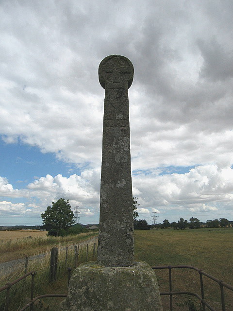
Crosshall cross

The Crosshall Cross is a cross at Crosshall Farm, Eccles, in the Scottish Borders area of Scotland, in historic Berwickshire. The cross is situated near...

Eden Water

Eden Water is a tributary of the River Tweed in the Scottish Borders of Scotland. "Water" is the Lowland Scots term for a small river. The Eden Burn rises...

Ednam

Ednam is a small village near Kelso in the Scottish Borders area of Scotland. Places nearby include Stichill, Sprouston, Nenthorn, Eccles, Gordon, Greenlaw...

Nearby Amenities

Located within 500m of 55.657683,-2.3896611
Give Way
Direction: backward
Lat/Long: 55.6570075/-2.3870553
Wormerlaw
Place: hamlet
Lat/Long: 55.6573926/-2.3879953
Wormer Law
Natural: peak
Lat/Long: 55.6566323/-2.39105
Power: pole
Lat/Long: 55.655279/-2.3840095
Power: pole
Lat/Long: 55.6557337/-2.3851927
Power: pole
Lat/Long: 55.656311/-2.3860774
Power: pole
Lat/Long: 55.6568726/-2.3869536
Power: pole
Lat/Long: 55.6570506/-2.3872904
Power: pole
Lat/Long: 55.6572983/-2.3878063
Power: pole
Lat/Long: 55.6576026/-2.3884991
The data included in this document is from www.openstreetmap.org. The data is made available under ODbL.

Have you been to Wormer Law?

Leave your review of Wormer Law below (or comments, questions and feedback).