Black Hill

Hill, Mountain in Berwickshire

Scotland

Black Hill

Kidshielhaugh farm buildings At the end of a 1.4km rough track from the B6355.
Kidshielhaugh farm buildings Credit: M J Richardson

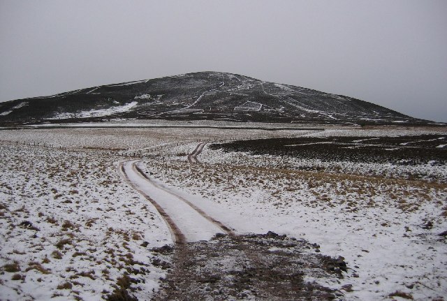
Black Hill is a prominent hill located in the region of Berwickshire, Scotland. It forms part of the Southern Uplands, a range of hills and mountains that run across the southern region of Scotland. Standing at an impressive elevation of 638 meters (2,093 feet), it is a popular destination for outdoor enthusiasts and nature lovers.

The hill is characterized by its distinctive conical shape and is known for its stunning panoramic views of the surrounding landscape. From its summit, visitors can enjoy breathtaking vistas of the rolling hills, lush valleys, and charming villages that dot the Berwickshire countryside. On clear days, one can even catch a glimpse of the North Sea shimmering in the distance.

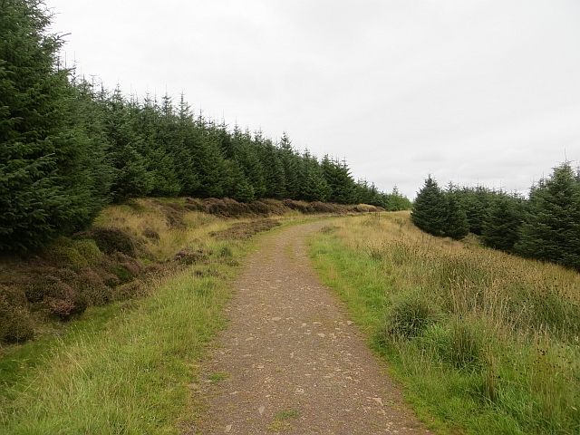
Black Hill is accessible via various walking routes, with the most popular starting from the nearby village of Longformacus. The ascent is moderately challenging, with some steep sections, but the well-maintained paths and trails make it feasible for walkers of most abilities. The hill is also a favorite among avid birdwatchers, as it is home to a diverse range of avian species, including peregrine falcons and red grouse.

In addition to its natural beauty, Black Hill holds historical significance as well. The remnants of an Iron Age hillfort can be found on its slopes, serving as a reminder of the area's ancient past.

Overall, Black Hill offers visitors a captivating blend of natural splendor, recreational opportunities, and historical intrigue, making it a must-visit destination for those exploring the Berwickshire region.

If you have any feedback on the listing, please let us know in the comments section below.

Black Hill Images

Images are sourced within 2km of 55.7977/-2.4324182 or Grid Reference NT7256. Thanks to Geograph Open Source API. All images are credited.

Kidshielhaugh farm buildings At the end of a 1.4km rough track from the B6355.
Kidshielhaugh farm buildings
At the end of a 1.4km rough track from the B6355.
Communications mast on Hardens Hill A substantial mast carrying several microwave dishes and aerials.
Communications mast on Hardens Hill
A substantial mast carrying several microwave dishes and aerials.
Route to Black Hill The footpath marker carries signs for Duns Paths and Scottish Rights of Way Society. Black Hill wind farm is ahead, with other turbines on the skyline, probably at Crystal Rig just beyond Whiteadder Reservoir.
Route to Black Hill
The footpath marker carries signs for Duns Paths and Scottish Rights of Way Society. Black Hill wind farm is ahead, with other turbines on the skyline, probably at Crystal Rig just beyond Whiteadder Reservoir.
White Burn Deeply incised valleys such as this are common in the Lammermuir Hills.
White Burn
Deeply incised valleys such as this are common in the Lammermuir Hills.
Grazing below the turbines, Black Hill Cattle and sheep beyond turbine 21 in the Black Hill wind farm.
Grazing below the turbines, Black Hill
Cattle and sheep beyond turbine 21 in the Black Hill wind farm.
Substation building, Black Hill The microwave dish will provide the data link needed to monitor and control the turbines.
Substation building, Black Hill
The microwave dish will provide the data link needed to monitor and control the turbines.
Kirk Hill from Black Hill A view back to Kirk Hill and the masts on Hardens Hill, from the wind farm service road.
Kirk Hill from Black Hill
A view back to Kirk Hill and the masts on Hardens Hill, from the wind farm service road.
At turbine 10, Black Hill wind farm A view to the wooded hillsides E of Longformacus.
At turbine 10, Black Hill wind farm
A view to the wooded hillsides E of Longformacus.
Wolfhope Burn One of the burns draining eastwards from Black Hill into Mill Burn, a tributary of the Whiteadder Water which itself eventually joins the Tweed close to Berwick after a tortuous course through the lower-lying land east of the Lammermuir Hills.
Wolfhope Burn
One of the burns draining eastwards from Black Hill into Mill Burn, a tributary of the Whiteadder Water which itself eventually joins the Tweed close to Berwick after a tortuous course through the lower-lying land east of the Lammermuir Hills.
Edge of the woodland at Commonside The woodland strip on the left is not shown on the 1:25,000 map.
Edge of the woodland at Commonside
The woodland strip on the left is not shown on the 1:25,000 map.
Ruined farmhouse at Commonside Compare with <a href="https://www.geograph.org.uk/photo/399754">NT7357 : Commonside</a> taken in April 2007 - the brick wall to the left in that image has since collapsed.
Ruined farmhouse at Commonside
Compare with NT7357 : Commonside taken in April 2007 - the brick wall to the left in that image has since collapsed.
Black Hill wind farm from Commonside
Southern Upland Way signpost, Commonside At this point the Duns Paths route from the Snuffy Hole car park meets the Southern Upland Way. The post indicates 'Viewpoint 50 metres' to the S.
Southern Upland Way signpost, Commonside
At this point the Duns Paths route from the Snuffy Hole car park meets the Southern Upland Way. The post indicates 'Viewpoint 50 metres' to the S.
Track on Langton Edge A forestry road that leads to the car park at Snuffy Hole.
Track on Langton Edge
A forestry road that leads to the car park at Snuffy Hole.
Black Hill Wind Farm The 22 turbine wind farm became operational in 2007. This long telephoto shot was taken from the B6359 at Bowdenmoor.
Black Hill Wind Farm
The 22 turbine wind farm became operational in 2007. This long telephoto shot was taken from the B6359 at Bowdenmoor.
Snowy Berwickshire Scene A view across the snow covered marginal grazing land above Duns, on the road to Longformacus.
Snowy Berwickshire Scene
A view across the snow covered marginal grazing land above Duns, on the road to Longformacus.
Langton Edge track A small road runs through to Duns Wood through young conifers.
Langton Edge track
A small road runs through to Duns Wood through young conifers.
Road up Hardens Hill The climb from the Longformacus direction. The young trees surround a motocross track.
Road up Hardens Hill
The climb from the Longformacus direction. The young trees surround a motocross track.
Show me another place!

Black Hill is located at Grid Ref: NT7256 (Lat: 55.7977, Lng: -2.4324182)

Unitary Authority: The Scottish Borders

Police Authority: The Lothians and Scottish Borders

What 3 Words

///squad.renamed.spenders. Near Duns, Scottish Borders

Nearby Locations

Black Hill

Related Wikis

Berwickshire, Roxburgh and Selkirk (UK Parliament constituency)

Berwickshire, Roxburgh and Selkirk is a constituency of the British House of Commons, located in the south of Scotland within the Scottish Borders council...

Dirrington Great Law

Dirrington Great Law is a hill in the Scottish Borders area of Scotland, in the former county of Berwickshire. The summit is around 2.5 kilometres (1.6...

Longformacus House

Longformacus House is a mansion near the village of Longformacus, Scottish Borders, Scotland. == History == The estate was once owned by the Earls of...

Dye Water

The Dye Water (Scottish Gaelic: Uisge Dhàidh) is a river in the Lammermuir Hills in the Scottish Borders area of Scotland. It rises in the Hope Hills,...

Longformacus

Longformacus (Scottish Gaelic: Longphort Mhacais) is a small village in Berwickshire in the Scottish Borders area of Scotland. It is around 10 kilometres...

Borthwick Castle, Scottish Borders

Borthwick Castle, Scottish Borders was a 16th-century L-plan tower house, about 1 mile (1.6 km) north west of Duns, Scottish Borders, Scotland. == History... ==

Langton Castle

Langton Castle is a now destroyed medieval fortress at Langton, near the burgh of Duns, Berwickshire, Scotland. Little remains of the structure. ��2�...

Duns Castle nature reserve

Duns Castle nature reserve is a nature reserve near Duns, in the Scottish Borders area of Scotland, in the former Berwickshire. It consists of two man...

Nearby Amenities

Located within 500m of 55.7977,-2.4324182
Black Hill
Natural: peak
Lat/Long: 55.7979032/-2.4320468
Generator Method: wind_turbine
Generator Output Electricity: yes
Generator Source: wind
Generator Type: horizontal_axis
Power: generator
Lat/Long: 55.7941274/-2.4314331
Generator Method: wind_turbine
Generator Output Electricity: yes
Generator Source: wind
Generator Type: horizontal_axis
Power: generator
Lat/Long: 55.7962809/-2.4302794
Generator Method: wind_turbine
Generator Output Electricity: yes
Generator Source: wind
Generator Type: horizontal_axis
Power: generator
Lat/Long: 55.7969542/-2.4348164
Generator Method: wind_turbine
Generator Output Electricity: yes
Generator Source: wind
Generator Type: horizontal_axis
Power: generator
Lat/Long: 55.7974719/-2.4261942
Generator Method: wind_turbine
Generator Output Electricity: yes
Generator Source: wind
Generator Type: horizontal_axis
Power: generator
Lat/Long: 55.7978457/-2.4397516
Generator Method: wind_turbine
Generator Output Electricity: yes
Generator Source: wind
Generator Type: horizontal_axis
Power: generator
Lat/Long: 55.7985992/-2.4312308
Generator Method: wind_turbine
Generator Output Electricity: yes
Generator Source: wind
Generator Type: horizontal_axis
Power: generator
Lat/Long: 55.7997284/-2.4355776
Generator Method: wind_turbine
Generator Output Electricity: yes
Generator Source: wind
Generator Type: horizontal_axis
Power: generator
Lat/Long: 55.7998258/-2.4276911
Generator Method: wind_turbine
Generator Output Electricity: yes
Generator Source: wind
Generator Type: horizontal_axis
Power: generator
Lat/Long: 55.802103/-2.4340678
The data included in this document is from www.openstreetmap.org. The data is made available under ODbL.

Have you been to Black Hill?

Leave your review of Black Hill below (or comments, questions and feedback).