Eak Hill

Hill, Mountain in Yorkshire Ribble Valley

England

Eak Hill

View of Forest of Bowland from near Stocks Reservoir The view shows the River Hodder just after it flows into the Stocks reservoir. It flows south to join the River Ribble. The hills in the distance are part of the Forest of Bowland
View of Forest of Bowland from near Stocks Reservoir Credit: Rod Grealish

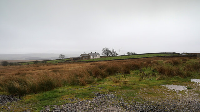
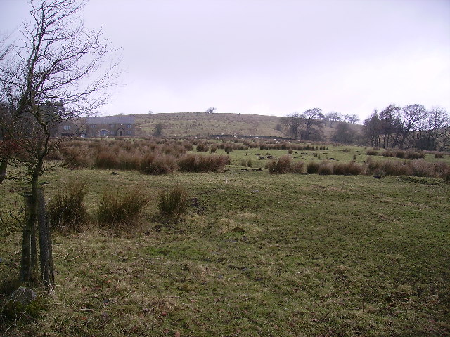
Eak Hill is a prominent hill located in the beautiful region of Yorkshire, England. Standing at an elevation of approximately 1,200 feet, it is often considered more of a hill than a mountain. Despite its modest height, Eak Hill offers breathtaking views of the surrounding countryside, making it a popular destination for hikers and nature enthusiasts.

The hill is characterized by its gentle slopes and lush greenery, which are a result of the favorable climate and fertile soil in the area. The landscape surrounding Eak Hill is dotted with charming villages, picturesque farmlands, and meandering rivers. Visitors can enjoy a leisurely walk through the meadows or embark on a more challenging hike to the summit, where they can take in panoramic views of the Yorkshire Dales.

Eak Hill is also known for its rich history and cultural significance. The area is home to several ancient archaeological sites, including burial mounds and stone circles, which provide insight into the lives of the early inhabitants of Yorkshire. Additionally, the hill has been a source of inspiration for many artists and writers over the years, with its tranquil and idyllic setting serving as a muse for their creative endeavors.

Whether it's exploring the diverse flora and fauna, immersing oneself in the local history, or simply enjoying the serenity of the Yorkshire countryside, Eak Hill offers an unforgettable experience for anyone seeking a connection with nature and a deeper appreciation for the beauty of the region.

If you have any feedback on the listing, please let us know in the comments section below.

Eak Hill Images

Images are sourced within 2km of 54.003219/-2.4240922 or Grid Reference SD7256. Thanks to Geograph Open Source API. All images are credited.

View of Forest of Bowland from near Stocks Reservoir The view shows the River Hodder just after it flows into the Stocks reservoir. It flows south to join the River Ribble. The hills in the distance are part of the Forest of Bowland
View of Forest of Bowland from near Stocks Reservoir
The view shows the River Hodder just after it flows into the Stocks reservoir. It flows south to join the River Ribble. The hills in the distance are part of the Forest of Bowland
River Hodder entering Stocks Reservoir The photo shows the point at which the River Hodder enters the Stocks Reservoir. The reservoir is at a particularly low level. It was opened in 1932 and supplies Blackpool and the Fylde coast. There are a number of waymarked forest walks and cycle routes. Trout fishing is available.
River Hodder entering Stocks Reservoir
The photo shows the point at which the River Hodder enters the Stocks Reservoir. The reservoir is at a particularly low level. It was opened in 1932 and supplies Blackpool and the Fylde coast. There are a number of waymarked forest walks and cycle routes. Trout fishing is available.
Gisburn Forest track A left turn to the north makes this easy-going teack a little harder as it is now gently uphill. Most of the forestry tracks are like this - low gradient and not too challenging for those on mountain bikes so old that suspension was not deemed necessary (at my age I want all the power I can generate to go into actual forward progress, not into compressing shock absorbers).
Gisburn Forest track
A left turn to the north makes this easy-going teack a little harder as it is now gently uphill. Most of the forestry tracks are like this - low gradient and not too challenging for those on mountain bikes so old that suspension was not deemed necessary (at my age I want all the power I can generate to go into actual forward progress, not into compressing shock absorbers).
St. James' Church, Dalehead A sign by the path in, on the left (west) says "Dalehead Church and Heritage Centre". Heritage possibly doesn't need a lot of energy - the centre has a wind turbine, but it seems to be well below tree-top height, which must limit its ability to kick out power. On the bright side, not many people seem to die here - it's an extensive graveyard with very few headstones.
St. James' Church, Dalehead
A sign by the path in, on the left (west) says "Dalehead Church and Heritage Centre". Heritage possibly doesn't need a lot of energy - the centre has a wind turbine, but it seems to be well below tree-top height, which must limit its ability to kick out power. On the bright side, not many people seem to die here - it's an extensive graveyard with very few headstones.
Tiny stream in Gisburn Forest A public footpath leaves School Lane to head northwest into the forest, but is scarcely visible on the ground. Crossing this stream, it climbs the muddy bank above to meet a recently made decent path, where the public right of way follows it for a short while towards Stocks reservoir before resuming its course into the forest and becoming totally vague once more. The new path also continues northeast, not a right of way but clearly much more frequented than the public footpath itself. Downhill, the new path passes into the open near the shore of the reservoir, and quite close to the car park at the corner of School Lane.
Tiny stream in Gisburn Forest
A public footpath leaves School Lane to head northwest into the forest, but is scarcely visible on the ground. Crossing this stream, it climbs the muddy bank above to meet a recently made decent path, where the public right of way follows it for a short while towards Stocks reservoir before resuming its course into the forest and becoming totally vague once more. The new path also continues northeast, not a right of way but clearly much more frequented than the public footpath itself. Downhill, the new path passes into the open near the shore of the reservoir, and quite close to the car park at the corner of School Lane.
Bird hide above the shore of Stocks Reservoir Tucked away on the edge of the forest, overlooking the shore of Stocks Reservoir, United Utilities have provided this and at least one other wildlife hide. It really is quite well concealed, whilst offering a clear view over many geese at the upstream end of the water (at least today). A barbed wire fence effectively deters one from getting any closer to the water, or, indeed, getting a clearer picture of the hide itself.
Bird hide above the shore of Stocks Reservoir
Tucked away on the edge of the forest, overlooking the shore of Stocks Reservoir, United Utilities have provided this and at least one other wildlife hide. It really is quite well concealed, whilst offering a clear view over many geese at the upstream end of the water (at least today). A barbed wire fence effectively deters one from getting any closer to the water, or, indeed, getting a clearer picture of the hide itself.
Footpath to White Hill House A small car park on a corner of School Lane (room for four cars, maybe five if carefully packed) serves this rather wet and muddy footpath heading into Gisburn Forest. The forest is popular with off-road cyclists, but this trail is one of those explicitly signed with a cycling prohibition which suited me fine - I wanted a nice wide track, thanks, and headed a little further south for my ride.
Footpath to White Hill House
A small car park on a corner of School Lane (room for four cars, maybe five if carefully packed) serves this rather wet and muddy footpath heading into Gisburn Forest. The forest is popular with off-road cyclists, but this trail is one of those explicitly signed with a cycling prohibition which suited me fine - I wanted a nice wide track, thanks, and headed a little further south for my ride.
Merrybent Hill
Merrybent Hill
Copped Hill Clough below Brunton Laithe The stream of Copped Hill Clough has cut quite a deep, tree-lined valley as it descends from Brunton Laithe towards its confluence with the River Hodder to flow into Stocks Reservoir. On the far side is a public footpath that manages to avoid contact with the minor road until 200m to the southwest (uphill) from this point.
Copped Hill Clough below Brunton Laithe
The stream of Copped Hill Clough has cut quite a deep, tree-lined valley as it descends from Brunton Laithe towards its confluence with the River Hodder to flow into Stocks Reservoir. On the far side is a public footpath that manages to avoid contact with the minor road until 200m to the southwest (uphill) from this point.
No School - School Lane No sign of a school in sight!  This just seems to be a pleasant forest drive!
No School - School Lane
No sign of a school in sight! This just seems to be a pleasant forest drive!
Micro Forest Moss atop a stone wall reminded me of a miniature forest!
Micro Forest
Moss atop a stone wall reminded me of a miniature forest!
Down School Lane Looking down School Lane towards the Stocks Reservoir.
Down School Lane
Looking down School Lane towards the Stocks Reservoir.
Path in the Forest of Bowland
Mossy Logs in the Forest of Bowland
Stocks Reservoir from near the Bird Hide
Looking out over Stocks Reservoir, Forest of Bowland Lovely view, great place to go Mountain Biking or Horse Riding on purpose-built trails
Looking out over Stocks Reservoir, Forest of Bowland
Lovely view, great place to go Mountain Biking or Horse Riding on purpose-built trails
Barn Near Brunton Laithe Looking across the Hodder Valley near Stocks Reservoir.
Barn Near Brunton Laithe
Looking across the Hodder Valley near Stocks Reservoir.
Harkers Farm On the road to Slaidburn in the wonderful Forest of Bowland
Harkers Farm
On the road to Slaidburn in the wonderful Forest of Bowland
Show me another place!

Eak Hill is located at Grid Ref: SD7256 (Lat: 54.003219, Lng: -2.4240922)

Division: West Riding

Administrative County: Lancashire

District: Ribble Valley

Police Authority: Lancashire

What 3 Words

///immediate.slime.carriage. Near Settle, North Yorkshire

Nearby Locations

Eak Hill Eak Hill Wood

Related Wikis

Stocks Reservoir

Stocks Reservoir is a reservoir situated at the head of the Hodder valley in the Forest of Bowland, Lancashire, England (historically in the West Riding...

Easington, Lancashire

Easington () is a civil parish within the Ribble Valley district of Lancashire, England, with a population in 2001 of 52. The Census 2011 population details...

Lancashire Witches Walk

The Lancashire Witches Walk is a 51-mile (82 km) long-distance footpath opened in 2012, between Barrowford and Lancaster, all in Lancashire, England. It...

Slaidburn

Slaidburn () is a village and civil parish within the Ribble Valley district of Lancashire, England. The parish covers just over 5,000 acres of the Forest...

Have you been to Eak Hill?

Leave your review of Eak Hill below (or comments, questions and feedback).