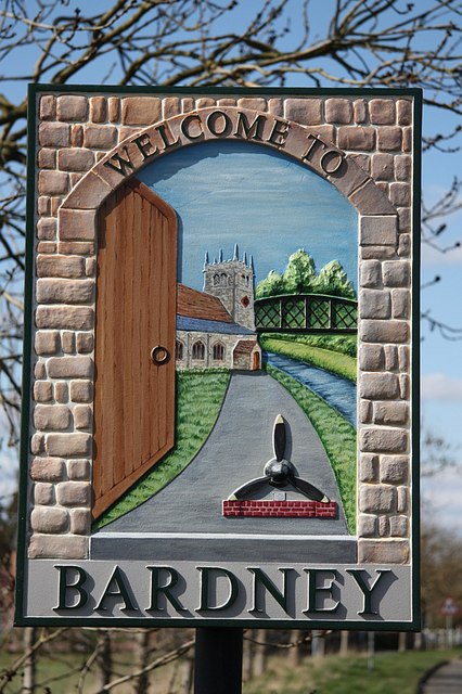
Bardney

Settlement in Lincolnshire West Lindsey

England

Bardney

Barlings Priory Site: aerial 2021 (3) See: <span class="nowrap"><a title="https://www.heritagegateway.org.uk/Gateway/Results_Single.aspx?uid=MLI54215&resourceID=1006" rel="nofollow ugc noopener" href="https://www.heritagegateway.org.uk/Gateway/Results_Single.aspx?uid=MLI54215&resourceID=1006">Link</a><img style="margin-left:2px;" alt="External link" title="External link - shift click to open in new window" src="https://s1.geograph.org.uk/img/external.png" width="10" height="10"/></span> and (upstanding remains): <span class="nowrap"><a title="https://www.heritagegateway.org.uk/Gateway/Results_Single.aspx?uid=MLI96528&resourceID=1006" rel="nofollow ugc noopener" href="https://www.heritagegateway.org.uk/Gateway/Results_Single.aspx?uid=MLI96528&resourceID=1006">Link</a><img style="margin-left:2px;" alt="External link" title="External link - shift click to open in new window" src="https://s1.geograph.org.uk/img/external.png" width="10" height="10"/></span>

Premonstratensian house founded 1154. Only part standing above ground is the NW pier of the crossing with a short length of wall between the nave and the N transept. This has nice c13 detail. The remainder of the site is unencumbered, being rough pasture, and it is possible that the whole ground could be recovered. No record can be found of any excavation.

Large area of earthworks and the NW pier and a short length of wall still standing; decoration on the wall is very similar to that in Southwell Minster chapter house. Other pieces of medieval masonry can be seen reused in the walls of the nearby cottage and its out-buildings.
Barlings Priory Site: aerial 2021 (3) Credit: Simon Tomson

Bardney is a small village located in the East Lindsey district of Lincolnshire, England. Situated on the eastern bank of the River Witham, it lies approximately 9 miles east of the city of Lincoln. The village has a population of around 2,000 residents.

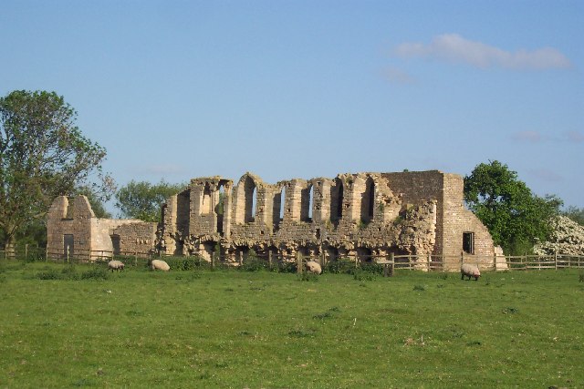
Historically, Bardney was an important religious center and was home to Bardney Abbey, which was founded in the 7th century. The abbey played a significant role in the region's history until its dissolution during the reign of Henry VIII.

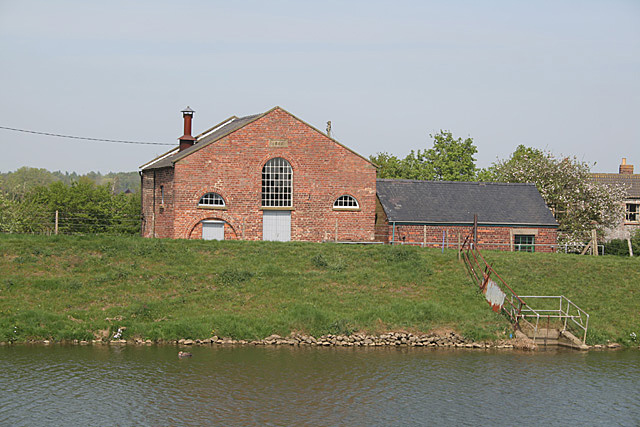
Today, Bardney retains some of its historical charm with a few remnants of the abbey still visible, including the abbey gatehouse. The village is also known for its picturesque surroundings, with the River Witham flowing through the nearby countryside, providing opportunities for scenic walks and outdoor activities.

Bardney is a close-knit community with a range of local amenities, including a primary school, a village hall, a post office, and a few shops and pubs. The village hosts various events and activities throughout the year, such as the Bardney Gala and the annual Bardney Beer Festival, which attract visitors from neighboring areas.

Despite its relatively small size, Bardney benefits from good transport links, with regular bus services connecting it to nearby towns and villages. The village also enjoys easy access to the A158 and A15 roads, providing convenient routes to Lincoln and other major cities in the region.

Overall, Bardney offers a peaceful and idyllic setting, making it an attractive place to live for those seeking a quiet village lifestyle with easy access to nearby urban amenities.

If you have any feedback on the listing, please let us know in the comments section below.
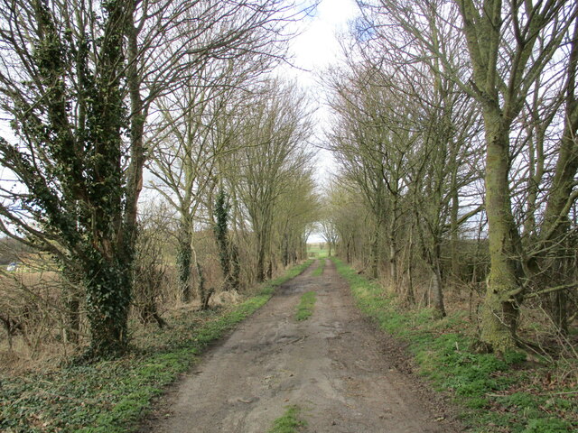
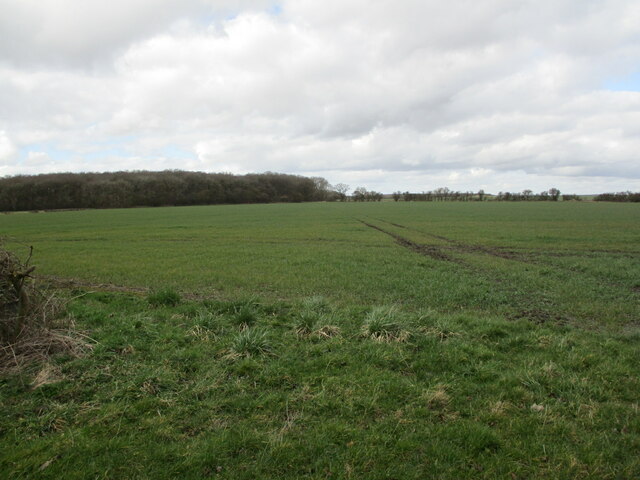
Bardney Images

Images are sourced within 2km of 53.210281/-0.323926 or Grid Reference TF1269. Thanks to Geograph Open Source API. All images are credited.

Barlings Priory Site: aerial 2021 (3) See: <span class="nowrap"><a title="https://www.heritagegateway.org.uk/Gateway/Results_Single.aspx?uid=MLI54215&resourceID=1006" rel="nofollow ugc noopener" href="https://www.heritagegateway.org.uk/Gateway/Results_Single.aspx?uid=MLI54215&resourceID=1006">Link</a><img style="margin-left:2px;" alt="External link" title="External link - shift click to open in new window" src="https://s1.geograph.org.uk/img/external.png" width="10" height="10"/></span> and (upstanding remains): <span class="nowrap"><a title="https://www.heritagegateway.org.uk/Gateway/Results_Single.aspx?uid=MLI96528&resourceID=1006" rel="nofollow ugc noopener" href="https://www.heritagegateway.org.uk/Gateway/Results_Single.aspx?uid=MLI96528&resourceID=1006">Link</a><img style="margin-left:2px;" alt="External link" title="External link - shift click to open in new window" src="https://s1.geograph.org.uk/img/external.png" width="10" height="10"/></span>

Premonstratensian house founded 1154. Only part standing above ground is the NW pier of the crossing with a short length of wall between the nave and the N transept. This has nice c13 detail. The remainder of the site is unencumbered, being rough pasture, and it is possible that the whole ground could be recovered. No record can be found of any excavation.

Large area of earthworks and the NW pier and a short length of wall still standing; decoration on the wall is very similar to that in Southwell Minster chapter house. Other pieces of medieval masonry can be seen reused in the walls of the nearby cottage and its out-buildings.
Barlings Priory Site: aerial 2021 (3)
See: LinkExternal link and (upstanding remains): LinkExternal link Premonstratensian house founded 1154. Only part standing above ground is the NW pier of the crossing with a short length of wall between the nave and the N transept. This has nice c13 detail. The remainder of the site is unencumbered, being rough pasture, and it is possible that the whole ground could be recovered. No record can be found of any excavation. Large area of earthworks and the NW pier and a short length of wall still standing; decoration on the wall is very similar to that in Southwell Minster chapter house. Other pieces of medieval masonry can be seen reused in the walls of the nearby cottage and its out-buildings.
Site of Bardney Abbey: aerial 2021 (2) See <span class="nowrap"><a title="https://www.heritagegateway.org.uk/Gateway/Results_Single.aspx?uid=MLI54217&resourceID=1006" rel="nofollow ugc noopener" href="https://www.heritagegateway.org.uk/Gateway/Results_Single.aspx?uid=MLI54217&resourceID=1006">Link</a><img style="margin-left:2px;" alt="External link" title="External link - shift click to open in new window" src="https://s1.geograph.org.uk/img/external.png" width="10" height="10"/></span>.

Bardney Abbey was founded before AD697. Ethelred, King of Mercia became its abbot in 705. It was destroyed by Danes in AD870, and rebuilt by Gilbert of Ghent. 

A Benedictine priory, dependent upon Charroux, was founded in 1087 although this was raised to the rank of an abbey in 1115. The house was dissolved and passed into the King's hands in 1538. Six monks were executed in 1536 after the Lincolnshire Rising.
Site of Bardney Abbey: aerial 2021 (2)
See LinkExternal link. Bardney Abbey was founded before AD697. Ethelred, King of Mercia became its abbot in 705. It was destroyed by Danes in AD870, and rebuilt by Gilbert of Ghent. A Benedictine priory, dependent upon Charroux, was founded in 1087 although this was raised to the rank of an abbey in 1115. The house was dissolved and passed into the King's hands in 1538. Six monks were executed in 1536 after the Lincolnshire Rising.
Site of Bardney Abbey: aerial 2021 (1) See <span class="nowrap"><a title="https://www.heritagegateway.org.uk/Gateway/Results_Single.aspx?uid=MLI54217&resourceID=1006" rel="nofollow ugc noopener" href="https://www.heritagegateway.org.uk/Gateway/Results_Single.aspx?uid=MLI54217&resourceID=1006">Link</a><img style="margin-left:2px;" alt="External link" title="External link - shift click to open in new window" src="https://s1.geograph.org.uk/img/external.png" width="10" height="10"/></span>.

Bardney Abbey was founded before AD697. Ethelred, King of Mercia became its abbot in 705. It was destroyed by Danes in AD870, and rebuilt by Gilbert of Ghent. 

A Benedictine priory, dependent upon Charroux, was founded in 1087 although this was raised to the rank of an abbey in 1115. The house was dissolved and passed into the King's hands in 1538. Six monks were executed in 1536 after the Lincolnshire Rising.
Site of Bardney Abbey: aerial 2021 (1)
See LinkExternal link. Bardney Abbey was founded before AD697. Ethelred, King of Mercia became its abbot in 705. It was destroyed by Danes in AD870, and rebuilt by Gilbert of Ghent. A Benedictine priory, dependent upon Charroux, was founded in 1087 although this was raised to the rank of an abbey in 1115. The house was dissolved and passed into the King's hands in 1538. Six monks were executed in 1536 after the Lincolnshire Rising.
Site of Bardney Abbey: aerial 2021 (3) See <span class="nowrap"><a title="https://www.heritagegateway.org.uk/Gateway/Results_Single.aspx?uid=MLI54217&resourceID=1006" rel="nofollow ugc noopener" href="https://www.heritagegateway.org.uk/Gateway/Results_Single.aspx?uid=MLI54217&resourceID=1006">Link</a><img style="margin-left:2px;" alt="External link" title="External link - shift click to open in new window" src="https://s1.geograph.org.uk/img/external.png" width="10" height="10"/></span>.

Bardney Abbey was founded before AD697. Ethelred, King of Mercia became its abbot in 705. It was destroyed by Danes in AD870, and rebuilt by Gilbert of Ghent. 

A Benedictine priory, dependent upon Charroux, was founded in 1087 although this was raised to the rank of an abbey in 1115. The house was dissolved and passed into the King's hands in 1538. Six monks were executed in 1536 after the Lincolnshire Rising.
Site of Bardney Abbey: aerial 2021 (3)
See LinkExternal link. Bardney Abbey was founded before AD697. Ethelred, King of Mercia became its abbot in 705. It was destroyed by Danes in AD870, and rebuilt by Gilbert of Ghent. A Benedictine priory, dependent upon Charroux, was founded in 1087 although this was raised to the rank of an abbey in 1115. The house was dissolved and passed into the King's hands in 1538. Six monks were executed in 1536 after the Lincolnshire Rising.
Former route of Henry Lane Now leads to a bridleway.
Former route of Henry Lane
Now leads to a bridleway.
Autumn sown crop and Scotgrove Wood
Bridleway to the B1202 Follows the line of the hedge.
Bridleway to the B1202
Follows the line of the hedge.
Remains of Bardney Abbey: aerial 2022 (1) See <span class="nowrap"><a title="https://www.heritagegateway.org.uk/Gateway/Results_Single.aspx?uid=MLI54217&resourceID=1006" rel="nofollow ugc noopener" href="https://www.heritagegateway.org.uk/Gateway/Results_Single.aspx?uid=MLI54217&resourceID=1006">Link</a><img style="margin-left:2px;" alt="External link" title="External link - shift click to open in new window" src="https://s1.geograph.org.uk/img/external.png" width="10" height="10"/></span>.

Bardney Abbey was founded before AD697. Ethelred, King of Mercia became its abbot in 705. It was destroyed by Danes in AD870, and rebuilt by Gilbert of Ghent. 

A Benedictine priory, dependent upon Charroux, was founded in 1087 although this was raised to the rank of an abbey in 1115. The house was dissolved and passed into the King's hands in 1538. Six monks were executed in 1536 after the Lincolnshire Rising.
Remains of Bardney Abbey: aerial 2022 (1)
See LinkExternal link. Bardney Abbey was founded before AD697. Ethelred, King of Mercia became its abbot in 705. It was destroyed by Danes in AD870, and rebuilt by Gilbert of Ghent. A Benedictine priory, dependent upon Charroux, was founded in 1087 although this was raised to the rank of an abbey in 1115. The house was dissolved and passed into the King's hands in 1538. Six monks were executed in 1536 after the Lincolnshire Rising.
Remains of Bardney Abbey: aerial 2022 (2) See <span class="nowrap"><a title="https://www.heritagegateway.org.uk/Gateway/Results_Single.aspx?uid=MLI54217&resourceID=1006" rel="nofollow ugc noopener" href="https://www.heritagegateway.org.uk/Gateway/Results_Single.aspx?uid=MLI54217&resourceID=1006">Link</a><img style="margin-left:2px;" alt="External link" title="External link - shift click to open in new window" src="https://s1.geograph.org.uk/img/external.png" width="10" height="10"/></span>.

Bardney Abbey was founded before AD697. Ethelred, King of Mercia became its abbot in 705. It was destroyed by Danes in AD870, and rebuilt by Gilbert of Ghent. 

A Benedictine priory, dependent upon Charroux, was founded in 1087 although this was raised to the rank of an abbey in 1115. The house was dissolved and passed into the King's hands in 1538. Six monks were executed in 1536 after the Lincolnshire Rising.
Remains of Bardney Abbey: aerial 2022 (2)
See LinkExternal link. Bardney Abbey was founded before AD697. Ethelred, King of Mercia became its abbot in 705. It was destroyed by Danes in AD870, and rebuilt by Gilbert of Ghent. A Benedictine priory, dependent upon Charroux, was founded in 1087 although this was raised to the rank of an abbey in 1115. The house was dissolved and passed into the King's hands in 1538. Six monks were executed in 1536 after the Lincolnshire Rising.
Remains of Bardney Abbey: aerial 2022 (3) See <span class="nowrap"><a title="https://www.heritagegateway.org.uk/Gateway/Results_Single.aspx?uid=MLI54217&resourceID=1006" rel="nofollow ugc noopener" href="https://www.heritagegateway.org.uk/Gateway/Results_Single.aspx?uid=MLI54217&resourceID=1006">Link</a><img style="margin-left:2px;" alt="External link" title="External link - shift click to open in new window" src="https://s1.geograph.org.uk/img/external.png" width="10" height="10"/></span>.

Bardney Abbey was founded before AD697. Ethelred, King of Mercia became its abbot in 705. It was destroyed by Danes in AD870, and rebuilt by Gilbert of Ghent. 

A Benedictine priory, dependent upon Charroux, was founded in 1087 although this was raised to the rank of an abbey in 1115. The house was dissolved and passed into the King's hands in 1538. Six monks were executed in 1536 after the Lincolnshire Rising.
Remains of Bardney Abbey: aerial 2022 (3)
See LinkExternal link. Bardney Abbey was founded before AD697. Ethelred, King of Mercia became its abbot in 705. It was destroyed by Danes in AD870, and rebuilt by Gilbert of Ghent. A Benedictine priory, dependent upon Charroux, was founded in 1087 although this was raised to the rank of an abbey in 1115. The house was dissolved and passed into the King's hands in 1538. Six monks were executed in 1536 after the Lincolnshire Rising.
The River Witham above Bardney Lock In theory this is a navigable waterway but at the moment it clearly isn't. Compare with <a href="https://www.geograph.org.uk/photo/6518476">TF1070 : River Witham</a> of just over three years ago.
The River Witham above Bardney Lock
In theory this is a navigable waterway but at the moment it clearly isn't. Compare with TF1070 : River Witham of just over three years ago.
Junction of the Witham Navigation and the old course of the River Witham
Footbridge at Bardney Lock
Footpath to Bardney Lock The Water Rail Way on the right.
Footpath to Bardney Lock
The Water Rail Way on the right.
Bardney Lock The old course of the River Witham in the background.
Bardney Lock
The old course of the River Witham in the background.
The old course of the River Witham
Bardney Lock Bardney Lock on the River Witham controls the level of water behind the gate and allows the transfer of shipping between the different water levels.
Bardney Lock
Bardney Lock on the River Witham controls the level of water behind the gate and allows the transfer of shipping between the different water levels.
Factory, Bardney Sugar beet operations appear to have ceased, but British Sugar still uses the site for other activities.
Factory, Bardney
Sugar beet operations appear to have ceased, but British Sugar still uses the site for other activities.
Show me another place!

Bardney is located at Grid Ref: TF1269 (Lat: 53.210281, Lng: -0.323926)

Division: Parts of Lindsey

Administrative County: Lincolnshire

District: West Lindsey

Police Authority: Lincolnshire

What 3 Words

///nametag.unlimited.appeal. Near Bardney, Lincolnshire

Related Wikis

Bardney

Bardney is a village and civil parish in the West Lindsey district of Lincolnshire, England. The population of the civil parish was 1,643 at the 2001 census...

Bardney railway station

Bardney railway station was a station in Bardney, Lincolnshire. North of the station the line split in two with one branch going to Lincoln and the other...

Witham Third District IDB

Witham Third District IDB is an English internal drainage board set up under the terms of the Land Drainage Act 1930. The Board inherited the responsibilities...
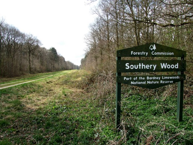
Southrey Wood

Southrey Wood is reserve near Bardney in the county of Lincolnshire, England. Butterfly Conservation manages this reserve. It is 22 acres (8.9 ha) in extent...

Bardney Abbey

Bardney Abbey in Lincolnshire, England, was a Benedictine monastery founded in 697 by King Æthelred of Mercia, who was to become the first abbot. The monastery...

Snakeholme Pit

Snakeholme Pit is a nature reserve near Langworth in the county of Lincolnshire, England, managed and owned by Butterfly Conservation. It is 2 acres.Animals...

Tupholme

Tupholme is a village in the East Lindsey district of Lincolnshire, England. It is situated 11 miles (18 km) east from Lincoln, and is the site of the...

Tupholme Abbey

Tupholme Abbey was a Premonstratensian abbey close to the River Witham some 10.5 miles (16.9 km) east of the city of Lincoln, England and one of nine such...

Nearby Amenities

Located within 500m of 53.210281,-0.323926
Bardney
Is In: Lincolnshire, England, UK
Old Name: Bardenai
Old Name 2: Beardaneu
Place: village
Source: Bing
Wikidata: Q808025
Wikipedia: en:Bardney
Lat/Long: 53.2105265/-0.3245785
Bus Stop
War Memorial
Naptan AtcoCode: 270000009595
Naptan Bearing: NW
Naptan CommonName: War Memorial
Naptan Indicator: opp
Naptan Landmark: War Memorial
Naptan NaptanCode: linjdjpa
Naptan Street: Horncastle Road
Naptan Verified: no
Source: naptan_import
Lat/Long: 53.2099086/-0.323631
Lea Grove
Naptan AtcoCode: 270000010468
Naptan Bearing: S
Naptan BusStopType: CUS
Naptan CommonName: Lea Grove
Naptan Indicator: adj
Naptan Landmark: Lea Grove
Naptan NaptanCode: linjmtgm
Naptan Street: Wragby Road
Naptan Verified: no
Source: naptan_import
Lat/Long: 53.2134112/-0.3201844
Harvey Kent Gardens
Naptan AtcoCode: 270002700436
Naptan Bearing: SW
Naptan BusStopType: CUS
Naptan CommonName: Harvey Kent Gardens
Naptan Indicator: opp
Naptan Landmark: Harvey Kent Gardens
Naptan NaptanCode: linagpmd
Naptan Street: Henry Lane
Naptan Verified: no
Source: naptan_import
Lat/Long: 53.2109957/-0.3165649
Wood Lane
Naptan AtcoCode: 270002701558
Naptan Bearing: NE
Naptan BusStopType: CUS
Naptan CommonName: Wood Lane
Naptan Indicator: adj
Naptan Landmark: Wood Lane
Naptan Street: Station Road
Naptan Verified: no
Source: naptan_import
Lat/Long: 53.2089906/-0.3299563
Wood Lane
Naptan AtcoCode: 270002701559
Naptan Bearing: SW
Naptan BusStopType: CUS
Naptan CommonName: Wood Lane
Naptan Indicator: opp
Naptan Landmark: Wood Lane
Naptan Street: Station Road
Naptan Verified: no
Source: naptan_import
Lat/Long: 53.208889/-0.3297656
Lea Grove
Naptan AtcoCode: 2700LBBG5119
Naptan Bearing: N
Naptan BusStopType: CUS
Naptan CommonName: Lea Grove
Naptan Indicator: opp
Naptan Landmark: Lea Grove
Naptan NaptanCode: lindptjw
Naptan Street: Wragby Road
Naptan Verified: no
Source: naptan_import
Lat/Long: 53.2134037/-0.3202895
Bus Stop
War Memorial
Note: Moved bus stop node back to its orginal location (from import) as someone moved it to the actual war Memorial
Naptan AtcoCode: 2700LBM00266
Naptan Bearing: SE
Naptan BusStopType: CUS
Naptan CommonName: War Memorial
Naptan Indicator: adj
Naptan Landmark: War Memorial
Naptan NaptanCode: linadjgt
Naptan Street: Horncastle Road
Naptan Verified: no
Source: naptan_import
Lat/Long: 53.2101731/-0.3237574
Barrier: bollard
Bicycle: no
Foot: yes
Lat/Long: 53.2079357/-0.3297061
Post Office
Bardney Post Office
Brand: Post Office
Brand Wikidata: Q1783168
Check Date: 2023-09-27
Ref Pol Id: 2955
Website: https://www.postoffice.co.uk/branch-finder/1523244/bardney
Lat/Long: 53.2101309/-0.3236186
Post Box
Lat/Long: 53.2126413/-0.3273661
Power: pole
Lat/Long: 53.213653/-0.3281442
Power: pole
Lat/Long: 53.2105/-0.3309229
Power: pole
Lat/Long: 53.2107112/-0.3289166
Power: pole
Lat/Long: 53.209704/-0.3309257
Power: pole
Lat/Long: 53.2139438/-0.3234664
Power: pole
Lat/Long: 53.2126443/-0.3219643
Power: pole
Lat/Long: 53.2098051/-0.3305579
Power: pole
Lat/Long: 53.2113881/-0.3282954
Power: pole
Lat/Long: 53.2104163/-0.3294394
Power: pole
Lat/Long: 53.2125464/-0.3282152
Power: pole
Lat/Long: 53.2134242/-0.3248397
Power: pole
Lat/Long: 53.2112107/-0.3310557
Power: pole
Lat/Long: 53.2111825/-0.3279789
Power: pole
Lat/Long: 53.2110403/-0.3283249
Power: pole
Lat/Long: 53.2134282/-0.3229139
Power: pole
Lat/Long: 53.2101016/-0.3309229
Crossing
Crossing: unmarked
Crossing Island: yes
Kerb: lowered
Tactile Paving: yes
Lat/Long: 53.2107272/-0.3246002
Bench
Source: Bing
Lat/Long: 53.2107618/-0.32415
Valley Farm
Place: farm
Source: Bing
Lat/Long: 53.2112558/-0.3272722
Pub
Black Horse
Name En: Black Horse
Lat/Long: 53.2116916/-0.322662
Description: Bardney Local Interest
Information: board
Tourism: information
Lat/Long: 53.2086179/-0.3305408
Bardney War Memorial
Historic: memorial
Memorial: war_memorial
Lat/Long: 53.2102578/-0.3237728
Barrier: yes
Lat/Long: 53.2104211/-0.3218992
Barrier: yes
Lat/Long: 53.2104792/-0.3216142
Generator Method: photovoltaic
Generator Output Electricity: yes
Generator Source: solar
Generator Type: solar_photovoltaic_panel
Location: roof
Power: generator
Lat/Long: 53.2116059/-0.3171077
Generator Method: photovoltaic
Generator Output Electricity: yes
Generator Source: solar
Generator Type: solar_photovoltaic_panel
Location: roof
Power: generator
Lat/Long: 53.211838/-0.3172056
Generator Method: photovoltaic
Generator Output Electricity: yes
Generator Source: solar
Generator Type: solar_photovoltaic_panel
Location: roof
Power: generator
Lat/Long: 53.2118131/-0.3173156
Generator Method: photovoltaic
Generator Output Electricity: yes
Generator Source: solar
Generator Type: solar_photovoltaic_panel
Location: roof
Power: generator
Lat/Long: 53.2125384/-0.3176119
Generator Method: photovoltaic
Generator Output Electricity: yes
Generator Source: solar
Generator Type: solar_photovoltaic_panel
Location: roof
Power: generator
Lat/Long: 53.212511/-0.3177085
Generator Method: photovoltaic
Generator Output Electricity: yes
Generator Source: solar
Generator Type: solar_photovoltaic_panel
Location: roof
Power: generator
Lat/Long: 53.2124757/-0.3178466
Generator Method: photovoltaic
Generator Output Electricity: yes
Generator Source: solar
Generator Type: solar_photovoltaic_panel
Location: roof
Power: generator
Lat/Long: 53.21245/-0.3179512
Generator Method: photovoltaic
Generator Output Electricity: yes
Generator Source: solar
Generator Type: solar_photovoltaic_panel
Location: roof
Power: generator
Lat/Long: 53.2126885/-0.3179888
Generator Method: photovoltaic
Generator Output Electricity: yes
Generator Source: solar
Generator Type: solar_photovoltaic_panel
Location: roof
Power: generator
Lat/Long: 53.2126436/-0.31832
Generator Method: photovoltaic
Generator Output Electricity: yes
Generator Source: solar
Generator Type: solar_photovoltaic_panel
Location: roof
Power: generator
Lat/Long: 53.2126122/-0.3184501
Generator Method: photovoltaic
Generator Output Electricity: yes
Generator Source: solar
Generator Type: solar_photovoltaic_panel
Location: roof
Power: generator
Lat/Long: 53.2125857/-0.3185467
Generator Method: photovoltaic
Generator Output Electricity: yes
Generator Source: solar
Generator Type: solar_photovoltaic_panel
Location: roof
Power: generator
Lat/Long: 53.2125584/-0.3186607
Generator Method: photovoltaic
Generator Output Electricity: yes
Generator Source: solar
Generator Type: solar_photovoltaic_panel
Location: roof
Power: generator
Lat/Long: 53.2114887/-0.3182758
Generator Method: photovoltaic
Generator Output Electricity: yes
Generator Source: solar
Generator Type: solar_photovoltaic_panel
Location: roof
Power: generator
Lat/Long: 53.2113762/-0.3189772
Generator Method: photovoltaic
Generator Output Electricity: yes
Generator Source: solar
Generator Type: solar_photovoltaic_panel
Location: roof
Power: generator
Lat/Long: 53.2113754/-0.3190375
Generator Method: photovoltaic
Generator Output Electricity: yes
Generator Source: solar
Generator Type: solar_photovoltaic_panel
Location: roof
Power: generator
Lat/Long: 53.2105843/-0.3181698
Generator Method: photovoltaic
Generator Output Electricity: yes
Generator Source: solar
Generator Type: solar_photovoltaic_panel
Location: roof
Power: generator
Lat/Long: 53.2106703/-0.3189597
Generator Method: photovoltaic
Generator Output Electricity: yes
Generator Source: solar
Generator Type: solar_photovoltaic_panel
Location: roof
Power: generator
Lat/Long: 53.2106687/-0.3197376
Generator Method: photovoltaic
Generator Output Electricity: yes
Generator Source: solar
Generator Type: solar_photovoltaic_panel
Location: roof
Power: generator
Lat/Long: 53.2097627/-0.3226008
Generator Method: photovoltaic
Generator Output Electricity: yes
Generator Source: solar
Generator Type: solar_photovoltaic_panel
Location: roof
Power: generator
Lat/Long: 53.2097161/-0.3227283
Generator Method: photovoltaic
Generator Output Electricity: yes
Generator Source: solar
Generator Type: solar_photovoltaic_panel
Location: roof
Power: generator
Lat/Long: 53.2096414/-0.3229308
Generator Method: photovoltaic
Generator Output Electricity: yes
Generator Source: solar
Generator Type: solar_photovoltaic_panel
Location: roof
Power: generator
Lat/Long: 53.2096986/-0.3236472
Generator Method: photovoltaic
Generator Output Electricity: yes
Generator Source: solar
Generator Type: solar_photovoltaic_panel
Location: roof
Power: generator
Lat/Long: 53.2103022/-0.3267043
Generator Method: photovoltaic
Generator Output Electricity: yes
Generator Source: solar
Generator Type: solar_photovoltaic_panel
Location: roof
Power: generator
Lat/Long: 53.2114519/-0.3262329
Generator Method: photovoltaic
Generator Output Electricity: yes
Generator Source: solar
Generator Type: solar_photovoltaic_panel
Location: roof
Power: generator
Lat/Long: 53.2133441/-0.3272991
Generator Method: photovoltaic
Generator Output Electricity: yes
Generator Source: solar
Generator Type: solar_photovoltaic_panel
Location: roof
Power: generator
Lat/Long: 53.2134356/-0.3270081
Generator Method: photovoltaic
Generator Output Electricity: yes
Generator Source: solar
Generator Type: solar_photovoltaic_panel
Location: roof
Power: generator
Lat/Long: 53.2133111/-0.3263201
Generator Method: photovoltaic
Generator Output Electricity: yes
Generator Source: solar
Generator Type: solar_photovoltaic_panel
Location: roof
Power: generator
Lat/Long: 53.2143174/-0.3255181
Generator Method: photovoltaic
Generator Output Electricity: yes
Generator Source: solar
Generator Type: solar_photovoltaic_panel
Location: roof
Power: generator
Lat/Long: 53.2135633/-0.3252204
Generator Method: photovoltaic
Generator Output Electricity: yes
Generator Source: solar
Generator Type: solar_photovoltaic_panel
Location: roof
Power: generator
Lat/Long: 53.2107885/-0.3232825
Generator Method: photovoltaic
Generator Output Electricity: yes
Generator Source: solar
Generator Type: solar_photovoltaic_panel
Location: roof
Power: generator
Lat/Long: 53.2110206/-0.3192712
Generator Method: photovoltaic
Generator Output Electricity: yes
Generator Source: solar
Generator Type: solar_photovoltaic_panel
Location: roof
Power: generator
Lat/Long: 53.2109532/-0.3192283
Bicycle Parking
Bicycle Parking: rack
Capacity: 4
Covered: no
Fee: no
Lat/Long: 53.2116059/-0.3234985
Recycling
Indoor: yes
Recycling Soft Plastics: yes
Lat/Long: 53.211662/-0.3234905
Direction: 270
Information: board
Tourism: information
Lat/Long: 53.2105995/-0.3240815
The data included in this document is from www.openstreetmap.org. The data is made available under ODbL.

Have you been to Bardney?

Leave your review of Bardney below (or comments, questions and feedback).