Eve Law

Hill, Mountain in Berwickshire

Scotland

Eve Law

Evelaw and Evelaw Tower A farm and a 16thC keep, the keep now in a ruinous state <span class="nowrap"><a title="https://canmore.org.uk/site/57425/evelaw-tower" rel="nofollow ugc noopener" href="https://canmore.org.uk/site/57425/evelaw-tower">Link</a><img style="margin-left:2px;" alt="External link" title="External link - shift click to open in new window" src="https://s1.geograph.org.uk/img/external.png" width="10" height="10"/></span> , at the end of a track east from Wedderlie.
Evelaw and Evelaw Tower Credit: M J Richardson

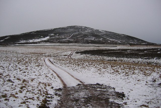
Eve Law is a prominent hill located in the county of Berwickshire, in the southeastern region of Scotland. Standing at an elevation of approximately 377 meters (1,237 feet), it offers breathtaking panoramic views of the surrounding countryside.

Situated near the charming village of Cockburnspath, Eve Law is a popular destination for hikers, nature enthusiasts, and locals alike. The hill is part of the Southern Uplands range, which stretches across the Scottish-English border, and is characterized by its rolling hills, heather-covered moorlands, and rocky outcrops.

The ascent to Eve Law is relatively moderate, making it accessible to hikers of various skill levels. The path to the summit is well-maintained and offers glimpses of diverse flora and fauna along the way. Once at the top, visitors are rewarded with sweeping vistas across the Berwickshire coast, the North Sea, and the nearby Lammermuir Hills.

Eve Law is also known for its historical significance. The hill is home to several ancient burial mounds, or cairns, dating back to the Neolithic period. These archaeological sites provide insights into the region's early human settlements and the rituals and customs of its inhabitants.

Overall, Eve Law in Berwickshire offers a memorable outdoor experience, combining natural beauty, cultural heritage, and recreational opportunities. Whether one seeks to enjoy a leisurely hike, capture stunning photographs, or delve into the region's history, this hill provides a captivating destination for all.

If you have any feedback on the listing, please let us know in the comments section below.

Eve Law Images

Images are sourced within 2km of 55.776738/-2.5349313 or Grid Reference NT6653. Thanks to Geograph Open Source API. All images are credited.

Evelaw and Evelaw Tower A farm and a 16thC keep, the keep now in a ruinous state <span class="nowrap"><a title="https://canmore.org.uk/site/57425/evelaw-tower" rel="nofollow ugc noopener" href="https://canmore.org.uk/site/57425/evelaw-tower">Link</a><img style="margin-left:2px;" alt="External link" title="External link - shift click to open in new window" src="https://s1.geograph.org.uk/img/external.png" width="10" height="10"/></span> , at the end of a track east from Wedderlie.
Evelaw and Evelaw Tower
A farm and a 16thC keep, the keep now in a ruinous state LinkExternal link , at the end of a track east from Wedderlie.
Small plantation near Evelaw And a delivery of 36 X 22.5kg tubs of SUPAlyx PLUS WITH FISH OIL, an extra high energy feed and mineral bucket for cattle and sheep. I thought about having a lick!
Small plantation near Evelaw
And a delivery of 36 X 22.5kg tubs of SUPAlyx PLUS WITH FISH OIL, an extra high energy feed and mineral bucket for cattle and sheep. I thought about having a lick!
Crossing place A gate, almost impossible to open in a dyke. There is moorland on both sides.  The map shows a path running southwards on the west side of the dyke, lies!  There is no crossing place over the next dyke on this side. If heading south towards the road you should ignore the Ordnance Survey and stay on the eastern side of the dyke here.
Crossing place
A gate, almost impossible to open in a dyke. There is moorland on both sides. The map shows a path running southwards on the west side of the dyke, lies! There is no crossing place over the next dyke on this side. If heading south towards the road you should ignore the Ordnance Survey and stay on the eastern side of the dyke here.
Moorland, Dirrington Heather moorland to the north of Dirrington Little Law.
Moorland, Dirrington
Heather moorland to the north of Dirrington Little Law.
Map error A dyke and electric fence blocks the path shown by the Ordnance Survey. The near dyke should be followed on the east side to a crossing place on the far dyke.
Map error
A dyke and electric fence blocks the path shown by the Ordnance Survey. The near dyke should be followed on the east side to a crossing place on the far dyke.
Evelaw fields Enclosed pasture on the edge of extensive moorland.
Evelaw fields
Enclosed pasture on the edge of extensive moorland.
Shelter belt, Evelaw The strip wood protects improved land at Evelaw from winds coming off the vast area of moorland to the east.
Shelter belt, Evelaw
The strip wood protects improved land at Evelaw from winds coming off the vast area of moorland to the east.
Weetfoot Bog Wetland area on the vast moors to the south of the Lammermuir Hills. Grazed by sheep and cattle.  The mapped path does not exist on the ground.
Weetfoot Bog
Wetland area on the vast moors to the south of the Lammermuir Hills. Grazed by sheep and cattle. The mapped path does not exist on the ground.
Evelaw Wet rough grazing on the southern side of the Lammermuir Hills.
Evelaw
Wet rough grazing on the southern side of the Lammermuir Hills.
Dyke, Dirrington Ignore the map and stay on the eastern side of this dyke if heading southwards. There is no crossing place on the next dyke on the western side.
Dyke, Dirrington
Ignore the map and stay on the eastern side of this dyke if heading southwards. There is no crossing place on the next dyke on the western side.
Electric spring A way through one of the electric fences.  This crossing place is east of the dyke junction. The 1:25,000 map shows the path running on the west side but there is no crossing place there.  Stay on the Dirrington Little Law side of the north-south running dyke.
Electric spring
A way through one of the electric fences. This crossing place is east of the dyke junction. The 1:25,000 map shows the path running on the west side but there is no crossing place there. Stay on the Dirrington Little Law side of the north-south running dyke.
Rough grazing Grassland on Dirrington Little Law, the mapped path does not exist other than as a nicety on Scottish Borders Council's core path map. Still no need to not walk/ride it though as there is a crossing place onto moorland here and the going is easy.
Rough grazing
Grassland on Dirrington Little Law, the mapped path does not exist other than as a nicety on Scottish Borders Council's core path map. Still no need to not walk/ride it though as there is a crossing place onto moorland here and the going is easy.
Crossing place, Weetford Bog A way through one of the many electric fences between Longformacus and Greenlaw. The fencing manages cattle grazing on rough upland pasture.
Crossing place, Weetford Bog
A way through one of the many electric fences between Longformacus and Greenlaw. The fencing manages cattle grazing on rough upland pasture.
Woodland, Evelaw One of the small woods scattered about the farm.
Woodland, Evelaw
One of the small woods scattered about the farm.
Wetland, Rawburn The air is damp too, thanks to a haar.
Wetland, Rawburn
The air is damp too, thanks to a haar.
Road junction Left for Rawburn Cottage, straight on for some fields within the moorland.
Road junction
Left for Rawburn Cottage, straight on for some fields within the moorland.
Woodland, Rawburn Cottage A sheltering conifer wood.
Woodland, Rawburn Cottage
A sheltering conifer wood.
Old Plantation Looks as if the wood was replanted a few years earlier. There are enclosed fields here, within a mostly moorland environment.
Old Plantation
Looks as if the wood was replanted a few years earlier. There are enclosed fields here, within a mostly moorland environment.
Show me another place!

Eve Law is located at Grid Ref: NT6653 (Lat: 55.776738, Lng: -2.5349313)

Unitary Authority: The Scottish Borders

Police Authority: The Lothians and Scottish Borders

What 3 Words

///island.headlight.prone. Near Duns, Scottish Borders

Related Wikis

Watch Water

The Watch Water is a river in the Scottish Borders area of Scotland. It rises in the Lammermuir Hills, around 8 kilometres (5.0 mi) west of Longformacus...

Blackadder Water

Blackadder Water () is a river in Berwickshire in the Scottish Borders area of Scotland, forming part of the River Tweed system. It reached 2.84m at Mouthbridge...

Bedshiel

Bedshiel is a village in the Scottish Borders area of Scotland on the B6456, six miles from Duns, two miles from Greenlaw, Longformacus and Westruther...

Dirrington Great Law

Dirrington Great Law is a hill in the Scottish Borders area of Scotland, in the former county of Berwickshire. The summit is around 2.5 kilometres (1.6...

Nearby Amenities

Located within 500m of 55.776738,-2.5349313
Eve Law
Natural: peak
Lat/Long: 55.7761252/-2.5349291
The data included in this document is from www.openstreetmap.org. The data is made available under ODbL.

Have you been to Eve Law?

Leave your review of Eve Law below (or comments, questions and feedback).