Hard Hillock

Hill, Mountain in Aberdeenshire

Scotland

Hard Hillock

Tillyfourie Recumbent Stone Circle (1) Just to confuse people, this circle is signposted as Whitehill Stone Circle, and also so named in the 'Stone Circle Trail' leaflet published in 2014. I am sticking to the name used by the Royal Commission on the Ancient and Historical Monuments of Scotland, now part of Historic Environment Scotland. See <span class="nowrap"><a title="https://canmore.org.uk/site/18074/tillyfourie" rel="nofollow ugc noopener" href="https://canmore.org.uk/site/18074/tillyfourie">Link</a><img style="margin-left:2px;" alt="External link" title="External link - shift click to open in new window" src="https://s1.geograph.org.uk/img/external.png" width="10" height="10"/></span> for more information. <a href="https://www.geograph.org.uk/photo/4855469">NJ6413 : Tillyfourie Recumbent Stone Circle (2)</a>
Tillyfourie Recumbent Stone Circle (1) Credit: Anne Burgess

Hard Hillock is a prominent hill located in Aberdeenshire, Scotland. Situated in the eastern region of the country, it is part of the mesmerizing landscape of the Scottish Highlands. With an elevation of approximately 1,500 feet (457 meters), it stands proudly as a challenging hill for climbers and hikers alike.

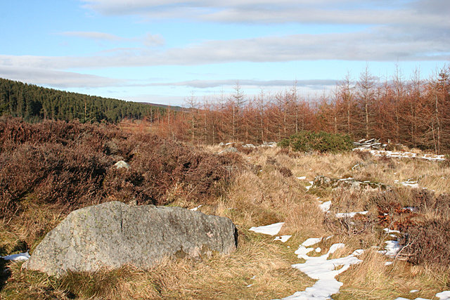
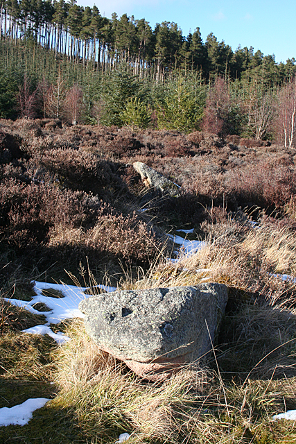
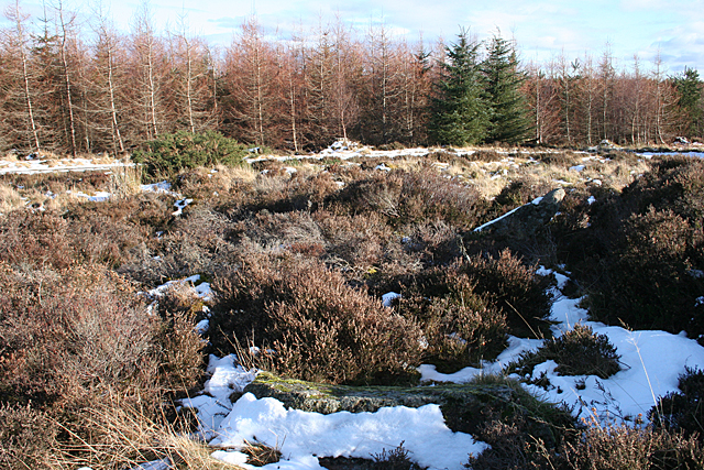
The hill is characterized by its steep slopes and rugged terrain, making it a popular destination for outdoor enthusiasts seeking a thrilling adventure. Its rocky outcrops and scree slopes provide a rewarding experience for those who conquer its summit. From the top of Hard Hillock, visitors are rewarded with breathtaking panoramic views of the surrounding countryside, including the Aberdeenshire countryside, rolling hills, and distant peaks.

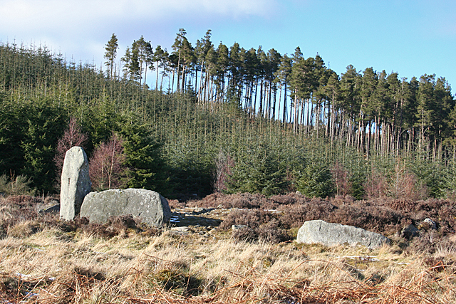
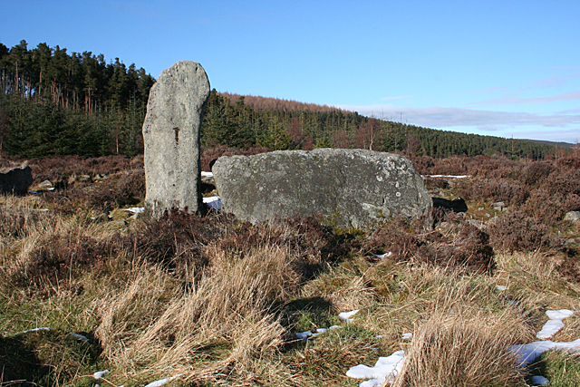
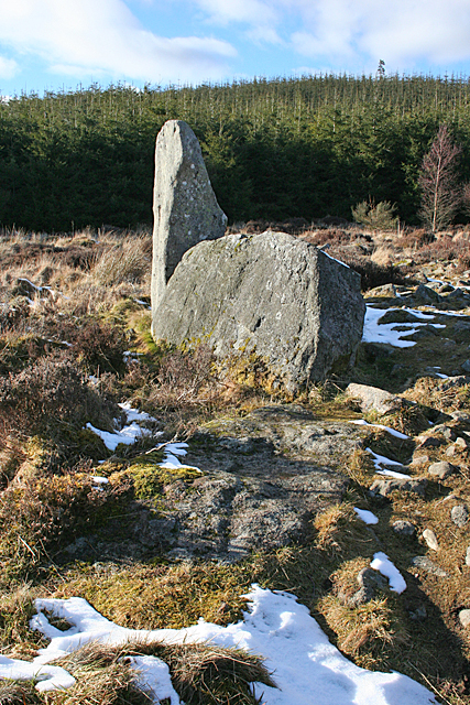
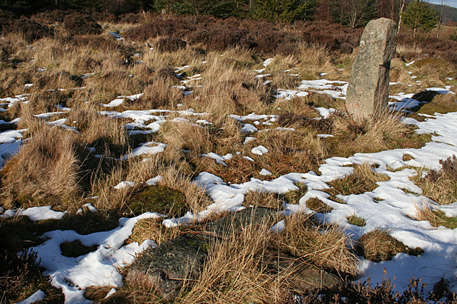
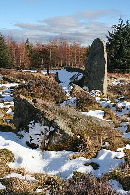
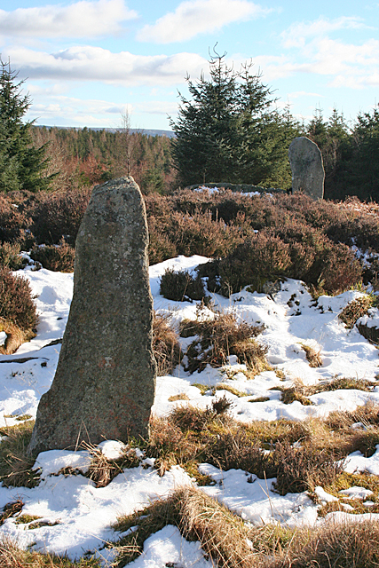
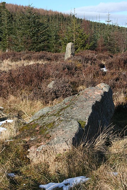
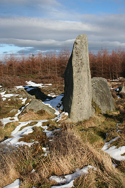
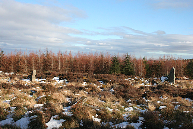
The hill is home to a diverse range of flora and fauna, with heather-covered moorlands and scattered woodlands dotting its lower slopes. Various bird species, such as peregrine falcons and golden eagles, can be spotted soaring through the skies above. In addition, the hill boasts a rich history, with remnants of ancient settlements and stone circles scattered throughout its vicinity.

Hard Hillock is easily accessible, with a network of well-maintained trails leading to its summit. The hill attracts both experienced trekkers seeking a challenging climb and beginners looking to explore the beauty of the Scottish countryside. Its unique blend of natural beauty, challenging terrain, and historical significance make Hard Hillock an enchanting destination for outdoor enthusiasts and nature lovers alike.

If you have any feedback on the listing, please let us know in the comments section below.
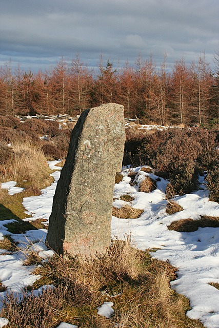
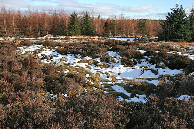
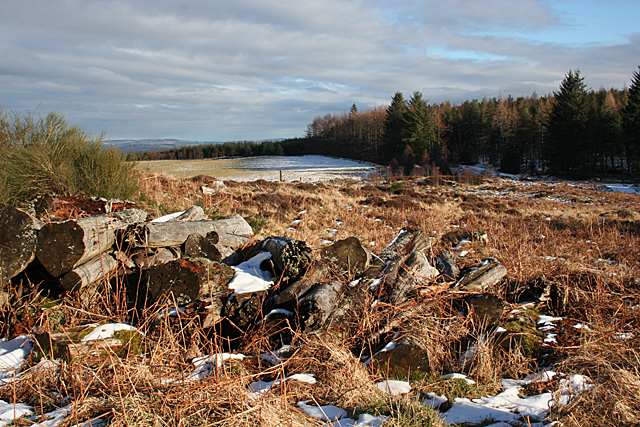
Hard Hillock Images

Images are sourced within 2km of 57.201542/-2.570965 or Grid Reference NJ6512. Thanks to Geograph Open Source API. All images are credited.

Tillyfourie Recumbent Stone Circle (1) Just to confuse people, this circle is signposted as Whitehill Stone Circle, and also so named in the 'Stone Circle Trail' leaflet published in 2014. I am sticking to the name used by the Royal Commission on the Ancient and Historical Monuments of Scotland, now part of Historic Environment Scotland. See <span class="nowrap"><a title="https://canmore.org.uk/site/18074/tillyfourie" rel="nofollow ugc noopener" href="https://canmore.org.uk/site/18074/tillyfourie">Link</a><img style="margin-left:2px;" alt="External link" title="External link - shift click to open in new window" src="https://s1.geograph.org.uk/img/external.png" width="10" height="10"/></span> for more information. <a href="https://www.geograph.org.uk/photo/4855469">NJ6413 : Tillyfourie Recumbent Stone Circle (2)</a>
Tillyfourie Recumbent Stone Circle (1)
Just to confuse people, this circle is signposted as Whitehill Stone Circle, and also so named in the 'Stone Circle Trail' leaflet published in 2014. I am sticking to the name used by the Royal Commission on the Ancient and Historical Monuments of Scotland, now part of Historic Environment Scotland. See LinkExternal link for more information. NJ6413 : Tillyfourie Recumbent Stone Circle (2)
Tillyfourie Recumbent Stone Circle (2) This is the recumbent setting. Only the west flanker and the recumbent are still standing.  See <span class="nowrap"><a title="https://canmore.org.uk/site/18074/tillyfourie" rel="nofollow ugc noopener" href="https://canmore.org.uk/site/18074/tillyfourie">Link</a><img style="margin-left:2px;" alt="External link" title="External link - shift click to open in new window" src="https://s1.geograph.org.uk/img/external.png" width="10" height="10"/></span> for more information. <a href="https://www.geograph.org.uk/photo/4855473">NJ6413 : Tillyfourie Recumbent Stone Circle (3)</a>
Tillyfourie Recumbent Stone Circle (2)
This is the recumbent setting. Only the west flanker and the recumbent are still standing. See LinkExternal link for more information. NJ6413 : Tillyfourie Recumbent Stone Circle (3)
Tillyfourie Recumbent Stone Circle (3) From this angle, the fallen east flanker can be seen embedded in the ground almost in line with the recumbent. When erect it would have been about the same height as the west flanker. See <span class="nowrap"><a title="https://canmore.org.uk/site/18074/tillyfourie" rel="nofollow ugc noopener" href="https://canmore.org.uk/site/18074/tillyfourie">Link</a><img style="margin-left:2px;" alt="External link" title="External link - shift click to open in new window" src="https://s1.geograph.org.uk/img/external.png" width="10" height="10"/></span> for more information. 
<a href="https://www.geograph.org.uk/photo/4855479">NJ6413 : Tillyfourie Recumbent Stone Circle (4)</a>
Tillyfourie Recumbent Stone Circle (3)
From this angle, the fallen east flanker can be seen embedded in the ground almost in line with the recumbent. When erect it would have been about the same height as the west flanker. See LinkExternal link for more information. NJ6413 : Tillyfourie Recumbent Stone Circle (4)
Tillyfourie Recumbent Stone Circle (4) The large stone in the left foreground is a fallen orthostat, and another one is visible lying in the grass towards the right. The heather behind the nearer one is growing on the internal cairn, which is raised above the level of the base of the stones.  See <span class="nowrap"><a title="https://canmore.org.uk/site/18074/tillyfourie" rel="nofollow ugc noopener" href="https://canmore.org.uk/site/18074/tillyfourie">Link</a><img style="margin-left:2px;" alt="External link" title="External link - shift click to open in new window" src="https://s1.geograph.org.uk/img/external.png" width="10" height="10"/></span> for more information. <a href="https://www.geograph.org.uk/photo/4855481">NJ6413 : Tillyfourie Recumbent Stone Circle (5)</a>
Tillyfourie Recumbent Stone Circle (4)
The large stone in the left foreground is a fallen orthostat, and another one is visible lying in the grass towards the right. The heather behind the nearer one is growing on the internal cairn, which is raised above the level of the base of the stones. See LinkExternal link for more information. NJ6413 : Tillyfourie Recumbent Stone Circle (5)
Tillyfourie Recumbent Stone Circle (5) The two fallen stones in this view are part of the eastern arc of the circle.  See <span class="nowrap"><a title="https://canmore.org.uk/site/18074/tillyfourie" rel="nofollow ugc noopener" href="https://canmore.org.uk/site/18074/tillyfourie">Link</a><img style="margin-left:2px;" alt="External link" title="External link - shift click to open in new window" src="https://s1.geograph.org.uk/img/external.png" width="10" height="10"/></span> for more information. <a href="https://www.geograph.org.uk/photo/4855485">NJ6413 : Tillyfourie Recumbent Stone Circle (6)</a>
Tillyfourie Recumbent Stone Circle (5)
The two fallen stones in this view are part of the eastern arc of the circle. See LinkExternal link for more information. NJ6413 : Tillyfourie Recumbent Stone Circle (6)
Tillyfourie Recumbent Stone Circle (6) It's quite hard to make out the fallen stones in this view. There is one in the foreground, with snow on the nearer face of it, and the next one is lying at an angle, with a thin layer of snow on top picking it out. These are the orthostats on the north-eastern arc of the circle.  See <span class="nowrap"><a title="https://canmore.org.uk/site/18074/tillyfourie" rel="nofollow ugc noopener" href="https://canmore.org.uk/site/18074/tillyfourie">Link</a><img style="margin-left:2px;" alt="External link" title="External link - shift click to open in new window" src="https://s1.geograph.org.uk/img/external.png" width="10" height="10"/></span> for more information. <a href="https://www.geograph.org.uk/photo/4855491">NJ6413 : Tillyfourie Recumbent Stone Circle (7)</a>
Tillyfourie Recumbent Stone Circle (6)
It's quite hard to make out the fallen stones in this view. There is one in the foreground, with snow on the nearer face of it, and the next one is lying at an angle, with a thin layer of snow on top picking it out. These are the orthostats on the north-eastern arc of the circle. See LinkExternal link for more information. NJ6413 : Tillyfourie Recumbent Stone Circle (7)
Tillyfourie Recumbent Stone Circle (7) At top right is the only orthostat still standing, and in the foreground are several fragments of another stone, almost hidden by a combination of grass and shadow. See <span class="nowrap"><a title="https://canmore.org.uk/site/18074/tillyfourie" rel="nofollow ugc noopener" href="https://canmore.org.uk/site/18074/tillyfourie">Link</a><img style="margin-left:2px;" alt="External link" title="External link - shift click to open in new window" src="https://s1.geograph.org.uk/img/external.png" width="10" height="10"/></span> for more information. <a href="https://www.geograph.org.uk/photo/4855496">NJ6413 : Tillyfourie Recumbent Stone Circle (8)</a>
Tillyfourie Recumbent Stone Circle (7)
At top right is the only orthostat still standing, and in the foreground are several fragments of another stone, almost hidden by a combination of grass and shadow. See LinkExternal link for more information. NJ6413 : Tillyfourie Recumbent Stone Circle (8)
Tillyfourie Recumbent Stone Circle (8) Nearest the camera is a large fallen orthostat, and behind it is the recumbent setting.  See <span class="nowrap"><a title="https://canmore.org.uk/site/18074/tillyfourie" rel="nofollow ugc noopener" href="https://canmore.org.uk/site/18074/tillyfourie">Link</a><img style="margin-left:2px;" alt="External link" title="External link - shift click to open in new window" src="https://s1.geograph.org.uk/img/external.png" width="10" height="10"/></span> for more information. <a href="https://www.geograph.org.uk/photo/4855503">NJ6413 : Tillyfourie Recumbent Stone Circle (9)</a>
Tillyfourie Recumbent Stone Circle (8)
Nearest the camera is a large fallen orthostat, and behind it is the recumbent setting. See LinkExternal link for more information. NJ6413 : Tillyfourie Recumbent Stone Circle (9)
Tillyfourie Recumbent Stone Circle (9) In this view are all the stones still standing. The closest one is the stone standing on the north arc, and in the background is the west flanker. The recumbent, to the left of the flanker, is almost hidden by the heather growing on the raised internal cairn.  See <span class="nowrap"><a title="https://canmore.org.uk/site/18074/tillyfourie" rel="nofollow ugc noopener" href="https://canmore.org.uk/site/18074/tillyfourie">Link</a><img style="margin-left:2px;" alt="External link" title="External link - shift click to open in new window" src="https://s1.geograph.org.uk/img/external.png" width="10" height="10"/></span> for more information. <a href="https://www.geograph.org.uk/photo/4855507">NJ6413 : Tillyfourie Recumbent Stone Circle (10)</a>
Tillyfourie Recumbent Stone Circle (9)
In this view are all the stones still standing. The closest one is the stone standing on the north arc, and in the background is the west flanker. The recumbent, to the left of the flanker, is almost hidden by the heather growing on the raised internal cairn. See LinkExternal link for more information. NJ6413 : Tillyfourie Recumbent Stone Circle (10)
Tillyfourie Recumbent Stone Circle (10) The nearest stone is the fallen stone next to the recumbent setting, and in the background is the only orthostat still upright.  See <span class="nowrap"><a title="https://canmore.org.uk/site/18074/tillyfourie" rel="nofollow ugc noopener" href="https://canmore.org.uk/site/18074/tillyfourie">Link</a><img style="margin-left:2px;" alt="External link" title="External link - shift click to open in new window" src="https://s1.geograph.org.uk/img/external.png" width="10" height="10"/></span> for more information. <a href="https://www.geograph.org.uk/photo/4855510">NJ6413 : Tillyfourie Recumbent Stone Circle (11)</a>
Tillyfourie Recumbent Stone Circle (10)
The nearest stone is the fallen stone next to the recumbent setting, and in the background is the only orthostat still upright. See LinkExternal link for more information. NJ6413 : Tillyfourie Recumbent Stone Circle (11)
Tillyfourie Recumbent Stone Circle (11) The recumbent setting, with the west flanker nearer the camera and the recumbent behind it.  See <span class="nowrap"><a title="https://canmore.org.uk/site/18074/tillyfourie" rel="nofollow ugc noopener" href="https://canmore.org.uk/site/18074/tillyfourie">Link</a><img style="margin-left:2px;" alt="External link" title="External link - shift click to open in new window" src="https://s1.geograph.org.uk/img/external.png" width="10" height="10"/></span> for more information. <a href="https://www.geograph.org.uk/photo/4855513">NJ6413 : Tillyfourie Recumbent Stone Circle (12)</a>
Tillyfourie Recumbent Stone Circle (11)
The recumbent setting, with the west flanker nearer the camera and the recumbent behind it. See LinkExternal link for more information. NJ6413 : Tillyfourie Recumbent Stone Circle (12)
Tillyfourie Recumbent Stone Circle (12) Thanks to the forest having been cleared around it, it is possible to get the whole circle in view, though all you really see are the west flanker, on the right, and the sole standing orthostat, on the left. You can also see that the height of the cairn in the interior of the circle is above the height of the base of the stones.  See <span class="nowrap"><a title="https://canmore.org.uk/site/18074/tillyfourie" rel="nofollow ugc noopener" href="https://canmore.org.uk/site/18074/tillyfourie">Link</a><img style="margin-left:2px;" alt="External link" title="External link - shift click to open in new window" src="https://s1.geograph.org.uk/img/external.png" width="10" height="10"/></span> for more information. <a href="https://www.geograph.org.uk/photo/4855515">NJ6413 : Tillyfourie Recumbent Stone Circle (13)</a>
Tillyfourie Recumbent Stone Circle (12)
Thanks to the forest having been cleared around it, it is possible to get the whole circle in view, though all you really see are the west flanker, on the right, and the sole standing orthostat, on the left. You can also see that the height of the cairn in the interior of the circle is above the height of the base of the stones. See LinkExternal link for more information. NJ6413 : Tillyfourie Recumbent Stone Circle (13)
Tillyfourie Recumbent Stone Circle (13) This is the only orthostat still standing. It is on the north arc of the circle.  See <span class="nowrap"><a title="https://canmore.org.uk/site/18074/tillyfourie" rel="nofollow ugc noopener" href="https://canmore.org.uk/site/18074/tillyfourie">Link</a><img style="margin-left:2px;" alt="External link" title="External link - shift click to open in new window" src="https://s1.geograph.org.uk/img/external.png" width="10" height="10"/></span> for more information. <a href="https://www.geograph.org.uk/photo/4855523">NJ6413 : Tillyfourie Recumbent Stone Circle (14)</a>
Tillyfourie Recumbent Stone Circle (13)
This is the only orthostat still standing. It is on the north arc of the circle. See LinkExternal link for more information. NJ6413 : Tillyfourie Recumbent Stone Circle (14)
Tillyfourie Recumbent Stone Circle (14) The raised cairn in the centre of the circle has itself been hollowed out to form a central court. It is surrounded by a kerb of 32 low stones, most of them obscured by the vegetation, even in dead of winter.  See <span class="nowrap"><a title="https://canmore.org.uk/site/18074/tillyfourie" rel="nofollow ugc noopener" href="https://canmore.org.uk/site/18074/tillyfourie">Link</a><img style="margin-left:2px;" alt="External link" title="External link - shift click to open in new window" src="https://s1.geograph.org.uk/img/external.png" width="10" height="10"/></span> for more information. <a href="https://www.geograph.org.uk/photo/4855467">NJ6413 : Tillyfourie Recumbent Stone Circle (1)</a>
Tillyfourie Recumbent Stone Circle (14)
The raised cairn in the centre of the circle has itself been hollowed out to form a central court. It is surrounded by a kerb of 32 low stones, most of them obscured by the vegetation, even in dead of winter. See LinkExternal link for more information. NJ6413 : Tillyfourie Recumbent Stone Circle (1)
Lichen I beileve these are the fruiting bodies of a lichen growing on one of the stones in the recumbent stone circle. I do not know what species they are.
Lichen
I beileve these are the fruiting bodies of a lichen growing on one of the stones in the recumbent stone circle. I do not know what species they are.
Forgotten Logs These large logs have evidently been forgotten when the forest was being cleared. They will no doubt provide habitat for assorted small wildlife.
Forgotten Logs
These large logs have evidently been forgotten when the forest was being cleared. They will no doubt provide habitat for assorted small wildlife.
Whitehills Just to show that there is more in this grid square than the recumbent stone circle, this is the farm from which the stone circle takes one of its names.
Whitehills
Just to show that there is more in this grid square than the recumbent stone circle, this is the farm from which the stone circle takes one of its names.
Bogmore Wood The bluish hint on the trees suggests that they are Douglas Fir. They make a pleasant change from Sitka Spruce. Through the gap, there's a distant glimpse of the village of Monymusk.
Bogmore Wood
The bluish hint on the trees suggests that they are Douglas Fir. They make a pleasant change from Sitka Spruce. Through the gap, there's a distant glimpse of the village of Monymusk.
Show me another place!

Hard Hillock is located at Grid Ref: NJ6512 (Lat: 57.201542, Lng: -2.570965)

Unitary Authority: Aberdeenshire

Police Authority: North East

What 3 Words

///lecturers.entry.cabbies. Near Sauchen, Aberdeenshire

Nearby Locations

Hard Hillock Glen Ton

Related Wikis

Tillyfourie railway station

Tillyfourie railway station was a railway station serving Tillyfourie, Aberdeenshire, Scotland. The station opened on 2 June 1860 on the Alford Valley...

Tillycairn Castle

Tillycairn Castle is an L-plan castle, dating from the 16th century, standing on high ground around 2.0 miles (3.2 km) south-east of Cluny in Aberdeenshire...

Tillyfourie

Tillyfourie is a hamlet in Aberdeenshire, Scotland. It is situated at the junction between the A944 road and the B993 road. A disused quarry and a stone...

A944 road

The A944 road connects Aberdeen with Strathdon in north-east Scotland. == Route == It originates at the Lang Stracht in the city, which is a re-routing...

Nearby Amenities

Located within 500m of 57.201542,-2.570965
Material: wood
Power: pole
Lat/Long: 57.2025804/-2.5702268
Material: wood
Power: pole
Lat/Long: 57.2027431/-2.5691727
Material: wood
Power: pole
Lat/Long: 57.2022128/-2.5730753
Material: wood
Power: pole
Lat/Long: 57.202377/-2.5717798
Material: wood
Power: pole
Lat/Long: 57.2025455/-2.5705487
Power: pole
Lat/Long: 57.2031108/-2.5682375
Power: pole
Lat/Long: 57.2034531/-2.5672563
Power: pole
Lat/Long: 57.2037954/-2.5662764
Power: pole
Lat/Long: 57.2041348/-2.5653311
Power: pole
Lat/Long: 57.2034396/-2.5646409
Power: pole
Lat/Long: 57.2030552/-2.5642528
Power: pole
Lat/Long: 57.2042684/-2.5745757
Power: pole
Lat/Long: 57.2037999/-2.573539
Power: pole
Lat/Long: 57.2032812/-2.5724149
Power: pole
Lat/Long: 57.2027474/-2.572049
Power: pole
Lat/Long: 57.2013472/-2.5785923
Power: pole
Lat/Long: 57.2015147/-2.5776456
Power: pole
Lat/Long: 57.2016836/-2.576559
Power: pole
Lat/Long: 57.2019704/-2.5757288
Power: pole
Lat/Long: 57.2020672/-2.5743511
The data included in this document is from www.openstreetmap.org. The data is made available under ODbL.

Have you been to Hard Hillock?

Leave your review of Hard Hillock below (or comments, questions and feedback).