Black Knowe

Hill, Mountain in Northumberland

England

Black Knowe

Sheepfold north of the Gair Burn At the side of a tributary of the Gair Burn.
Sheepfold north of the Gair Burn Credit: Phil Thirkell

Black Knowe is a prominent hill located in the county of Northumberland, in the northeastern region of England. It is part of the Pennines, a range of hills and mountains that stretch across northern England, and stands at an elevation of approximately 420 meters (1,378 feet) above sea level.

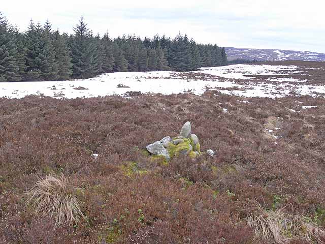
This hill is situated within the North Pennines Area of Outstanding Natural Beauty, a protected landscape renowned for its stunning scenery and diverse wildlife. Black Knowe offers visitors panoramic views of the surrounding countryside, with its distinctive shape and rugged terrain adding to its appeal.

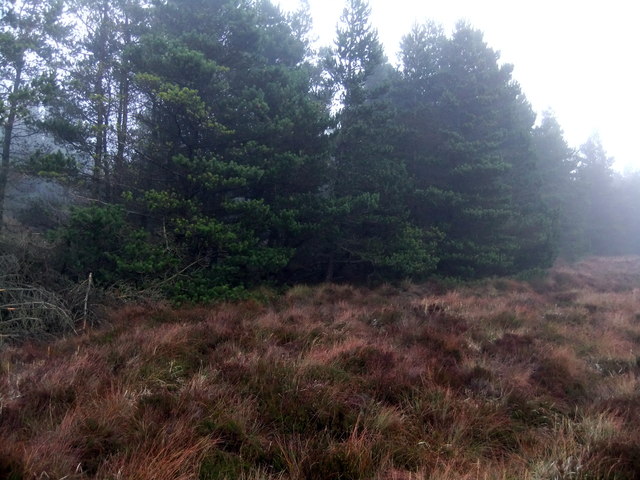
The hill is covered in a mix of grasses, heather, and bracken, creating a rich tapestry of colors throughout the seasons. It is also home to a variety of plant species, including bilberry, crowberry, and cotton grass. The area is an important habitat for a range of bird species, such as curlews, lapwings, and red grouse, which can often be spotted soaring above the hillside.

Black Knowe is a popular destination for outdoor enthusiasts, offering numerous walking trails and paths for hikers and nature lovers. The hill provides a challenging climb for those seeking adventure, with its steep slopes and rugged terrain providing a rewarding experience for those who reach its summit.

Overall, Black Knowe is a picturesque and captivating hill in Northumberland, attracting visitors with its natural beauty, breathtaking views, and opportunities for outdoor activities.

If you have any feedback on the listing, please let us know in the comments section below.

Black Knowe Images

Images are sourced within 2km of 55.123057/-2.5636785 or Grid Reference NY6481. Thanks to Geograph Open Source API. All images are credited.

Sheepfold north of the Gair Burn At the side of a tributary of the Gair Burn.
Sheepfold north of the Gair Burn
At the side of a tributary of the Gair Burn.
Corner of the wood, The Knares
Black Knowe Probably always misty here!
Black Knowe
Probably always misty here!
Old quarry Back in use to provide road metal for harvesting in the area.
Old quarry
Back in use to provide road metal for harvesting in the area.
Birkygrain Rigg View of Birkygrain Rigg in Wark Forest.
Birkygrain Rigg
View of Birkygrain Rigg in Wark Forest.
Humble Burn View looking across Humble Burn in Kielder Forest.
Humble Burn
View looking across Humble Burn in Kielder Forest.
Sheepfold Looking across Humble Burn to disused sheepfold in Kielder Forest.
Sheepfold
Looking across Humble Burn to disused sheepfold in Kielder Forest.
Birky Grain Track above Birky Grain in Kielder Forest.
Birky Grain
Track above Birky Grain in Kielder Forest.
Birky Grain Track above Birky Grain in Kielder Forest.
Birky Grain
Track above Birky Grain in Kielder Forest.
Birky Grain Small sike above Birky Grain in Kielder Forest.
Birky Grain
Small sike above Birky Grain in Kielder Forest.
Trig Pillar S7430, Black Knowe The pillar is in good condition apart from a horizontal crack above the flush bracket. The flush bracket faces 270°, west. The pillar was completed on 19th March 1953. Later in 1953 this marker was computed for triangulation as secondary station NY86/18 in the Hexham block. The flush bracket was levelled for height in 1958. The trig point was last maintained by the OS in August 1978. Views over Kielder Forest and to surrounding hills.
Trig Pillar S7430, Black Knowe
The pillar is in good condition apart from a horizontal crack above the flush bracket. The flush bracket faces 270°, west. The pillar was completed on 19th March 1953. Later in 1953 this marker was computed for triangulation as secondary station NY86/18 in the Hexham block. The flush bracket was levelled for height in 1958. The trig point was last maintained by the OS in August 1978. Views over Kielder Forest and to surrounding hills.
Sheepfold
Sheepfold
Humble Burn
Humble Burn
Ox Crags and the Knares An area of high moorland surrounded by plantations of the Kielder group of forests. A combination of unmanaged heather over part-frozen peat bog, interspersed with deep patches of snow made this the most difficult terrain I have ever walked. The rocky outcrop to the right is Ox Crags. The pinpoint on the horizon to the left is a Long Sal <a href="https://www.geograph.org.uk/gridref/NY6381">NY6381</a>, a remarkable currick just to the left (west) of the summit of Black Knowe <a href="https://www.geograph.org.uk/gridref/NY6481">NY6481</a>.
Ox Crags and the Knares
An area of high moorland surrounded by plantations of the Kielder group of forests. A combination of unmanaged heather over part-frozen peat bog, interspersed with deep patches of snow made this the most difficult terrain I have ever walked. The rocky outcrop to the right is Ox Crags. The pinpoint on the horizon to the left is a Long Sal NY6381, a remarkable currick just to the left (west) of the summit of Black Knowe NY6481.
Western end of Long Crags An area of high moorland surrounded by plantations of the Kielder group of forests.
Western end of Long Crags
An area of high moorland surrounded by plantations of the Kielder group of forests.
Western end of Long Crags An area of high moorland surrounded by plantations of the Kielder group of forests.  The summit on the horizon is Sighty Crags <a href="https://www.geograph.org.uk/gridref/NY6081">NY6081</a>..
Western end of Long Crags
An area of high moorland surrounded by plantations of the Kielder group of forests. The summit on the horizon is Sighty Crags NY6081..
Cairn on the Knares This rough cairn is almost the only mark left by man on this stretch of high moorland in the middle of Wark Forest. It appears to coincide with a spot height shown on the Landranger map at 461 metres.
Cairn on the Knares
This rough cairn is almost the only mark left by man on this stretch of high moorland in the middle of Wark Forest. It appears to coincide with a spot height shown on the Landranger map at 461 metres.
The Knares An area of high moorland surrounded by plantations of the Kielder group of forests. A combination of unmanaged heather over part-frozen peat bog, interspersed with deep patches of snow made this the most difficult terrain I have ever walked.  Even at this time of year, some heather burning seems to be taking place in the distance at the northern end of the Pennines.
The Knares
An area of high moorland surrounded by plantations of the Kielder group of forests. A combination of unmanaged heather over part-frozen peat bog, interspersed with deep patches of snow made this the most difficult terrain I have ever walked. Even at this time of year, some heather burning seems to be taking place in the distance at the northern end of the Pennines.
Show me another place!

Black Knowe is located at Grid Ref: NY6481 (Lat: 55.123057, Lng: -2.5636785)

Unitary Authority: Northumberland

Police Authority: Northumbria

What 3 Words

///offers.blotches.improvise. Near Greenhead, Northumberland

Nearby Locations

Humble Hill Black Knowe

Related Wikis

Sighty Crag

Sighty Crag is a hill in the southern part of the Kielder Forest region in northern England, a region which also includes its fellow Marilyns of Peel Fell...

Churnsike Lodge

Churnsike Lodge is an early Victorian hunting lodge situated in the parish of Greystead, West Northumberland, England. Constructed in 1850 by the Charlton...

Kielder Water

Kielder Water is a large man-made reservoir in Northumberland in North East England. It is the largest artificial lake in the United Kingdom by capacity...

Plashetts railway station

Plashetts railway station is a closed stone built railway station that served the mining hamlet of Plashetts, in Northumberland, England, which is now...

HMS Standard (shore establishment)

HMS Standard was a British Royal Navy shore establishment between 1942 and 1945. Situated well away from the sea near Kielder in Northumberland, the base...

Kielder Forest

Kielder Forest is a large forestry plantation in Northumberland, England, surrounding Kielder village and the Kielder Water reservoir. It is the largest...

Bewcastle Castle

Bewcastle Castle is a ruined castle in the parish of Bewcastle in the English county of Cumbria, a few miles from the Scottish border. == History == The...

Wark Forest

Wark Forest is the southern part of Kielder Forest in Northumberland, England. Wark Forest is found within the south-west tip of Northumberland National...

Nearby Amenities

Located within 500m of 55.123057,-2.5636785
Black Knowe
Place: locality
Lat/Long: 55.1237871/-2.5647191
Long Sal
Place: locality
Lat/Long: 55.1223922/-2.5692261
The data included in this document is from www.openstreetmap.org. The data is made available under ODbL.

Have you been to Black Knowe?

Leave your review of Black Knowe below (or comments, questions and feedback).