Deadwater Fell

Hill, Mountain in Northumberland

England

Deadwater Fell

View from north of Kielder to radome on Deadwater Fell Believed to be Deadwater Fell top centre.
View from north of Kielder to radome on Deadwater Fell Credit: Chris

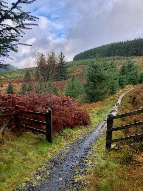
Deadwater Fell is a small hill located in Northumberland, a county in northern England. Situated near the border with Scotland, it forms part of the picturesque Kielder Forest and Water Park. Despite being called a hill, it is often considered more of a mountain due to its steep slopes and rugged terrain.

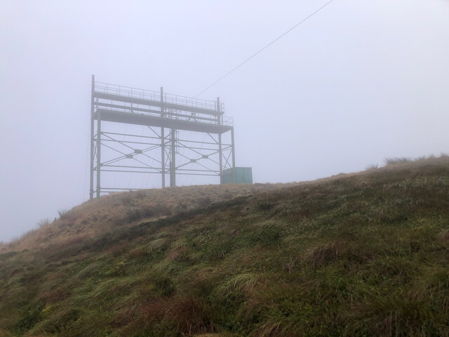
Rising to an elevation of approximately 550 meters (1,800 feet), Deadwater Fell offers breathtaking panoramic views of the surrounding countryside. Its summit provides a vantage point overlooking the sprawling Kielder Water, which is the largest man-made lake in Northern Europe. On clear days, visitors can also catch glimpses of the Cheviot Hills and the distant Scottish border.

The hill is a popular destination for outdoor enthusiasts and nature lovers. Its diverse landscape includes dense forests, heather moorland, and rocky outcrops. It offers a variety of walking and hiking trails, catering to different levels of difficulty and fitness. The area is also home to a rich array of wildlife, including red squirrels, deer, and a wide range of bird species.

Deadwater Fell is easily accessible, with several designated parking areas nearby and well-maintained paths leading to the summit. Visitors are advised to come prepared with appropriate footwear and clothing, as the weather can be unpredictable and conditions underfoot can be challenging.

Overall, Deadwater Fell is a stunning natural landmark, offering a chance to immerse oneself in the beauty of the Northumberland countryside and enjoy the tranquility of its surroundings.

If you have any feedback on the listing, please let us know in the comments section below.

Deadwater Fell Images

Images are sourced within 2km of 55.267209/-2.5906624 or Grid Reference NY6297. Thanks to Geograph Open Source API. All images are credited.

View from north of Kielder to radome on Deadwater Fell Believed to be Deadwater Fell top centre.
View from north of Kielder to radome on Deadwater Fell
Believed to be Deadwater Fell top centre.
Forestry road near Deadwater
Path/fence crossing
Path/fence crossing
Ravenshill Moor
Ravenshill Moor
Rock outcrop, Deadwater Fell
Electricity cable transmission testing rig
Deadwater Fell, eastern flank
Ravenshill Moor
Ravenshill Moor
On Ravenshill Moor
On Ravenshill Moor
Archer Cleugh View of Archer Cleugh.
Archer Cleugh
View of Archer Cleugh.
Forest road end, Kittythirst A group about to set off up Peel Fell. This was a celebration of the tenth anniversary of the first traverse of Scotland's East-West watershed by Dave Hewitt in 1987.  Peel Fell is where the watershed finally leaves the border and heads northwestwards into Scotland.

Fourteen years on the bare patch was once again covered in trees. <a href="https://www.geograph.org.uk/photo/2732973">NY6096 : Forest Track near Kittyhirst</a>
Forest road end, Kittythirst
A group about to set off up Peel Fell. This was a celebration of the tenth anniversary of the first traverse of Scotland's East-West watershed by Dave Hewitt in 1987. Peel Fell is where the watershed finally leaves the border and heads northwestwards into Scotland. Fourteen years on the bare patch was once again covered in trees. NY6096 : Forest Track near Kittyhirst
Ride, Peel Fell Ascent of Peel Fell through Kielder Forest. The ride soon reaches open country.

The event was a tenth anniversary celebration of the first traverse of Scotland's main watershed, between rivers flowing to the North Sea and Atlantic, by Dave Hewitt in 1987.
Ride, Peel Fell
Ascent of Peel Fell through Kielder Forest. The ride soon reaches open country. The event was a tenth anniversary celebration of the first traverse of Scotland's main watershed, between rivers flowing to the North Sea and Atlantic, by Dave Hewitt in 1987.
Forest road on the slopes of Deadwater Fell Looking down a section of forest road which provides a relatively easy route to the summit of the Fell. Clearfell to the right.
Forest road on the slopes of Deadwater Fell
Looking down a section of forest road which provides a relatively easy route to the summit of the Fell. Clearfell to the right.
Windthrow on the slopes of Deadwater Fell A common sight in Sitka Spruce plantations. When one goes, they all go.
Windthrow on the slopes of Deadwater Fell
A common sight in Sitka Spruce plantations. When one goes, they all go.
Footbridge on Lightpipe Sike On the signed walking route up Deadwater Fell, near Jimmy's Hill.
Footbridge on Lightpipe Sike
On the signed walking route up Deadwater Fell, near Jimmy's Hill.
Footpath at Jimmy's Hill The walker's route down from Deadwater Fell leaves the forest road through this gate. There are a number of mountain bike trails on the slopes of Deadwater Fell of varying degrees of severity. There is always the possibility of an accident in which case the notice advises telephoning 999. Unfortunately, however urgent the situation, this is not immediately possible. As the notice points out, the nearest mobile phone coverage is at Tower Knowe some 20 km away. Even the nearest landline phone is 3 km away and 100 m below down forest tracks. And as for the nearest hospital - that's at Hexham nearly 55 km away.
Footpath at Jimmy's Hill
The walker's route down from Deadwater Fell leaves the forest road through this gate. There are a number of mountain bike trails on the slopes of Deadwater Fell of varying degrees of severity. There is always the possibility of an accident in which case the notice advises telephoning 999. Unfortunately, however urgent the situation, this is not immediately possible. As the notice points out, the nearest mobile phone coverage is at Tower Knowe some 20 km away. Even the nearest landline phone is 3 km away and 100 m below down forest tracks. And as for the nearest hospital - that's at Hexham nearly 55 km away.
Downhill mountain bike trail at Jimmy's Hill The bottom of a "red" mountain bike trail, classified as "Difficult". As the notice at the top <a href="https://www.geograph.org.uk/photo/5505307">NY6295 : "Into the valley"</a> reads: "Suitable for proficient mountain bikes with good off-road riding skills". Strictly one-way only. The no-entry sign as the bottom reads "Cycllsts coming downhill at speed"
Downhill mountain bike trail at Jimmy's Hill
The bottom of a "red" mountain bike trail, classified as "Difficult". As the notice at the top NY6295 : "Into the valley" reads: "Suitable for proficient mountain bikes with good off-road riding skills". Strictly one-way only. The no-entry sign as the bottom reads "Cycllsts coming downhill at speed"
"Into the valley" The top of a "red" mountain bike trail which emerges at Jimmy's Hill <a href="https://www.geograph.org.uk/photo/5505300">NY6295 : Downhill mountain bike trail at Jimmy's Hill</a>. Red trails are classified as "Difficult";  the notice  reads: "Suitable for proficient mountain bikes with good off-road riding skills". As a downhill section, it is strictly one-way only.
"Into the valley"
The top of a "red" mountain bike trail which emerges at Jimmy's Hill NY6295 : Downhill mountain bike trail at Jimmy's Hill. Red trails are classified as "Difficult"; the notice reads: "Suitable for proficient mountain bikes with good off-road riding skills". As a downhill section, it is strictly one-way only.
Show me another place!

Deadwater Fell is located at Grid Ref: NY6297 (Lat: 55.267209, Lng: -2.5906624)

Unitary Authority: Northumberland

Police Authority: Northumbria

What 3 Words

///goodnight.spell.shorter. Near Rochester, Northumberland

Related Wikis

Deadwater, Northumberland

Deadwater is a small settlement in Northumberland, England, about 3 miles (5 km) north west of Kielder, Northumberland, on the English side of the border...

Deadwater railway station

Deadwater railway station is a closed railway station situated on the border between England and Scotland at the head of the North Tyne River. The station...

Kielder Forest Star Camp

The Kielder Forest Star Camp is an annual star party held each autumn and spring in Kielder Forest. The five night event is based on the Kielder Campsite...

Kielder railway station

Kielder railway station is a closed railway station that served the village hamlet of Kielder, Northumberland. == History == Kielder railway station was...

Nearby Amenities

Located within 500m of 55.267209,-2.5906624
Deadwater Fell
Natural: peak
Lat/Long: 55.2667516/-2.5911471
Man Made: tower
Operator: Arqiva
Source: visual survey;bing
Tower Type: communication
Lat/Long: 55.2654275/-2.590574
Flight Safety Navigational Aid
Man Made: tower
Operator: RAF
Source: visual survey;bing
Tower Type: communication
Lat/Long: 55.2671815/-2.5911474
Flight Safety Navigational Aid
Man Made: tower
Operator: RAF
Source: visual survey;bing
Tower Type: communication
Lat/Long: 55.267253/-2.5910629
Flight Safety Navigational Aid
Man Made: tower
Operator: RAF
Source: visual survey;bing
Tower Type: communication
Lat/Long: 55.2673989/-2.5912199
Man Made: tower
Operator: RAF
Source: visual survey;bing
Tower Type: communication
Lat/Long: 55.2679534/-2.5906354
Man Made: tower
Source: visual survey;bing
Tower Type: communication
Lat/Long: 55.2681088/-2.5904979
Man Made: surveillance
Source: visual survey;bing
Lat/Long: 55.266637/-2.5894957
Man Made: surveillance
Source: visual survey;bing
Lat/Long: 55.2669759/-2.5898451
Man Made: surveillance
Source: visual survey;bing
Lat/Long: 55.267308/-2.5897886
Man Made: surveillance
Source: visual survey;bing
Lat/Long: 55.2675435/-2.589727
Man Made: surveillance
Source: visual survey;bing
Lat/Long: 55.267994/-2.5906229
Man Made: surveillance
Source: visual survey;bing
Lat/Long: 55.2683245/-2.5898374
Barrier: cattle_grid
Source: survey
Lat/Long: 55.2689421/-2.5880527
Source: visual survey;bing
Tourism: viewpoint
Lat/Long: 55.2697383/-2.5897388
Man Made: survey_point
Ref: S7817
Source: survey
Lat/Long: 55.2672905/-2.5905711
Specere
Artist Name: David Adjaye
Tourism: artwork
Website: http://kielderartandarchitecture.com/art-architecture/specere.html
Lat/Long: 55.266595/-2.5905126
Power: tower
Lat/Long: 55.266628/-2.5894757
Power: tower
Lat/Long: 55.2683494/-2.5898337
Information: board
Tourism: information
Lat/Long: 55.2666757/-2.5903977
Board Type: nature
Information: board
Tourism: information
Lat/Long: 55.2697584/-2.5897747
The data included in this document is from www.openstreetmap.org. The data is made available under ODbL.

Have you been to Deadwater Fell?

Leave your review of Deadwater Fell below (or comments, questions and feedback).