Boorick Hill

Hill, Mountain in Cumberland Eden

England

Boorick Hill

Domed Field with cattle The field lies south-east of the village of Unthank and south of a tree-lined stream, probably named Limekiln Beck.
Domed Field with cattle Credit: Trevor Littlewood

Boorick Hill, located in Cumberland, is a prominent hill/mountain in the United Kingdom. With an elevation of approximately 453 meters (1,486 feet), it stands as an impressive natural landmark in the region. The hill is situated within the Lake District National Park, renowned for its stunning landscapes and picturesque surroundings.

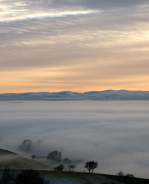
Boorick Hill is characterized by its distinctive shape and rugged terrain, making it a popular destination for hikers, climbers, and nature enthusiasts. The hill offers breathtaking panoramic views of the surrounding countryside, including rolling hills, lush valleys, and picturesque villages. On clear days, it is even possible to spot some of the nearby peaks, such as Skiddaw and Helvellyn.

The hill is covered in a mixture of heather, grass, and scattered rocky outcrops, creating a diverse habitat for various plant and animal species. Walkers can often spot wildlife such as red deer, foxes, and various bird species while exploring the area. The hill's unique flora and fauna make it an important ecological site within the Lake District.

Boorick Hill is easily accessible by foot, with several footpaths and trails leading up to its summit. However, visitors are advised to come prepared with appropriate hiking gear, as the terrain can be challenging in some areas. Additionally, it is crucial to respect the natural environment and adhere to the guidelines set by the Lake District National Park Authority to ensure the preservation of this beautiful landscape for future generations to enjoy.

If you have any feedback on the listing, please let us know in the comments section below.
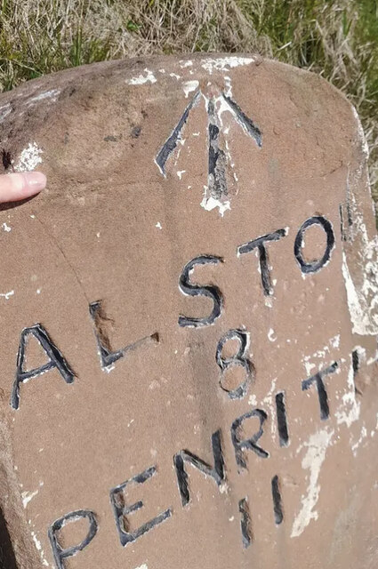
Boorick Hill Images

Images are sourced within 2km of 54.75063/-2.5835666 or Grid Reference NY6239. Thanks to Geograph Open Source API. All images are credited.

Domed Field with cattle The field lies south-east of the village of Unthank and south of a tree-lined stream, probably named Limekiln Beck.
Domed Field with cattle
The field lies south-east of the village of Unthank and south of a tree-lined stream, probably named Limekiln Beck.
Old Milestone by the A686, north east of Melmerby Carved stone post by the A686, in parish of OUSBY (EDEN District), Melmerby, Long Craggs, on bend, in banking, opposite Snow pole, on East side of road. Alston stone, erected by the Alston turnpike trust in the 19th century. 

Inscription reads:-
ALSTON
8
PENRITH
11 
Carved benchmark on front top.

Milestone Society National ID: CU_ALPR08.
Old Milestone by the A686, north east of Melmerby
Carved stone post by the A686, in parish of OUSBY (EDEN District), Melmerby, Long Craggs, on bend, in banking, opposite Snow pole, on East side of road. Alston stone, erected by the Alston turnpike trust in the 19th century. Inscription reads:- ALSTON 8 PENRITH 11 Carved benchmark on front top. Milestone Society National ID: CU_ALPR08.
Repurposed telephone box in Gamblesby With the ubiquity of the mobile phone, telephone boxes all over the UK have become redundant though many have found new uses. As here in Gamblesby, a storage location for defibrillators is a common one.
Repurposed telephone box in Gamblesby
With the ubiquity of the mobile phone, telephone boxes all over the UK have become redundant though many have found new uses. As here in Gamblesby, a storage location for defibrillators is a common one.
Public way leaving Gamblesby The walled lane leaves Gamblesby and heads almost exactly to the east, climbing to meet the A686. Here, the 'public way', (which on OS mapping uses the map symbol for a  byway), is emerging from overarching trees.
Public way leaving Gamblesby
The walled lane leaves Gamblesby and heads almost exactly to the east, climbing to meet the A686. Here, the 'public way', (which on OS mapping uses the map symbol for a byway), is emerging from overarching trees.
Grassy way separating fields near Gamblesby The fields both appear to be of stubble so presumably the growth in them not an intended crop. The red tinge is due to extensive amounts of red leg - Persicaria maculosa.
Grassy way separating fields near Gamblesby
The fields both appear to be of stubble so presumably the growth in them not an intended crop. The red tinge is due to extensive amounts of red leg - Persicaria maculosa.
Signpost in Gamblesby Cumbria has done well to retain many of the old cast iron Cumberland county council signposts, such as this one in Gamblesby.
Signpost in Gamblesby
Cumbria has done well to retain many of the old cast iron Cumberland county council signposts, such as this one in Gamblesby.
Heading down into the vale A view down the minor road which drops downhill from off the A686 towards Unthank and Gamblesby. The tree lined road contrasts with the open hillsides above, whilst this photo is very close to where the carboniferous rocks of the north Pennines give way to the younger sandstones of the Vale of Eden.
Heading down into the vale
A view down the minor road which drops downhill from off the A686 towards Unthank and Gamblesby. The tree lined road contrasts with the open hillsides above, whilst this photo is very close to where the carboniferous rocks of the north Pennines give way to the younger sandstones of the Vale of Eden.
Glassonby: The A686
Glassonby: The A686
Glassonby: Lime Kiln Beck
Direction Sign - Signpost on the A686 Located on the east side of the A686 opposite the road to Glassonby in Glassonby parish. 3 arms and pawn finial. See also <a title="https://www.geograph.org.uk/photo/3479373" href="https://www.geograph.org.uk/photo/3479373">Link</a>.

Milestone Society National ID: CU_NY6239
Direction Sign - Signpost on the A686
Located on the east side of the A686 opposite the road to Glassonby in Glassonby parish. 3 arms and pawn finial. See also Link. Milestone Society National ID: CU_NY6239
Pasture, Glassonby Very narrow fields rising to the Pennines from the footpath above Gamblesby.
Pasture, Glassonby
Very narrow fields rising to the Pennines from the footpath above Gamblesby.
Track at Gamblesby, Glassonby The public footpath entering the village from the west.
Track at Gamblesby, Glassonby
The public footpath entering the village from the west.
Ruined sheepfold on west flank of Knapside Hill Looking towards a distant Cross Fell.
Ruined sheepfold on west flank of Knapside Hill
Looking towards a distant Cross Fell.
Cairn above Blea Scar This large cairn is in prominent view on the descent from Knapside Hill. Across the hazy Eden Valley rise the northern fells of the Lake District.
Cairn above Blea Scar
This large cairn is in prominent view on the descent from Knapside Hill. Across the hazy Eden Valley rise the northern fells of the Lake District.
On the footpath above Gate Castle A grassy track drops down into a great open bowl beneath the North Pennines lorded over by a distant Cross Fell.
On the footpath above Gate Castle
A grassy track drops down into a great open bowl beneath the North Pennines lorded over by a distant Cross Fell.
Going nowhere, very slowly The remains of what look like a tractor engine and chassis rust gently away by the footpath above Blea Scar.
Going nowhere, very slowly
The remains of what look like a tractor engine and chassis rust gently away by the footpath above Blea Scar.
Trail bike damage below Knapside Hill These ruts were apparent much of the way from the footpath entry onto the open fell right across to Melmerby Fell <a title="https://www.geograph.org.uk/photo/2770490" href="https://www.geograph.org.uk/photo/2770490">Link</a> The people who ride these bikes (illegally) on public footpaths and over fragile ground could not care less about the environment. I have reported the problem to the North Pennines AONB unit so at least they are aware of the situation.
Trail bike damage below Knapside Hill
These ruts were apparent much of the way from the footpath entry onto the open fell right across to Melmerby Fell Link The people who ride these bikes (illegally) on public footpaths and over fragile ground could not care less about the environment. I have reported the problem to the North Pennines AONB unit so at least they are aware of the situation.
Trees in the mist, Lime Kiln Beck The cloud inversion that has filled the Eden Valley all day is lapping around these trees just below the A686 Alston road. On the far side the sun has just set below the eastern fells of the Lake District.
Trees in the mist, Lime Kiln Beck
The cloud inversion that has filled the Eden Valley all day is lapping around these trees just below the A686 Alston road. On the far side the sun has just set below the eastern fells of the Lake District.
Show me another place!

Boorick Hill is located at Grid Ref: NY6239 (Lat: 54.75063, Lng: -2.5835666)

Administrative County: Cumbria

District: Eden

Police Authority: Cumbria

What 3 Words

///bucket.stands.hires. Near Alston, Cumbria

Nearby Locations

Whinny Hill Boorick Hill

Related Wikis

Gamblesby

Gamblesby is a village near Melmerby, and former civil parish, now in the parish of Glassonby, in the Westmorland and Furness district, in the ceremonial...

St John's Church, Gamblesby

St. John's Church was a Victorian parish Church of England church in the village of Gamblesby, Cumbria, England.The Gothic Revival-style church, with tall...

Unthank, Glassonby

Unthank is a village near Gamblesby in the civil parish of Glassonby in Cumbria, England. It is first mentioned in writing as Unthanke in 1332. == See... ==

Melmerby, Cumbria

Melmerby is a village and civil parish in the Eden district, in the county of Cumbria, England. It is a small village with a population of around 200....

Nearby Amenities

Located within 500m of 54.75063,-2.5835666
Information: board
Tourism: information
Lat/Long: 54.7516553/-2.5795067
Historic: lime_kiln
Lat/Long: 54.753354/-2.5799858
Historic: lime_kiln
Lat/Long: 54.7541022/-2.580887
Abandoned: yes
Historic: mine_shaft
Lat/Long: 54.7532269/-2.577822
Barrier: kissing_gate
Lat/Long: 54.7516514/-2.5794824
Black Tongue
Place: locality
Lat/Long: 54.7496047/-2.5759873
Nettle Hole
Place: locality
Lat/Long: 54.7482537/-2.5799721
The data included in this document is from www.openstreetmap.org. The data is made available under ODbL.

Have you been to Boorick Hill?

Leave your review of Boorick Hill below (or comments, questions and feedback).