Coneygore Hill

Hill, Mountain in Somerset

England

Coneygore Hill

William Knoyle monument - Sandford Orcas parish church This painted alabaster wall-monument in the south chapel is to William Knoyle and dated 1607-8. He is depicted kneeling between his two wives and eleven children, seven of whom in black gowns (three sons, and four daughters) are shown kneeling. The remainder, an assortment of infants in swaddling clothes lie dead behind their mother.
William Knoyle monument - Sandford Orcas parish church Credit: Mike Searle

Coneygore Hill is a prominent geographical feature located in Somerset, England. It is classified as a hill rather than a mountain due to its relatively modest elevation, standing at approximately 227 meters (745 feet) above sea level. The hill is situated near the village of Glastonbury, known for its rich historical and cultural significance.

Coneygore Hill is part of the wider Mendip Hills, a range of limestone hills that stretch across Somerset and neighboring counties. Its distinct shape and position make it easily recognizable, with a gently sloping ascent that offers panoramic views of the surrounding countryside.

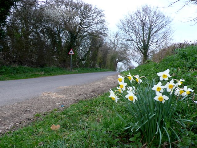
The hill is covered in lush green vegetation, typical of the English countryside, and is home to a variety of plant and animal species. The diverse flora and fauna make Coneygore Hill an attractive destination for nature enthusiasts and hikers alike.

In addition to its natural beauty, Coneygore Hill has a historical significance. It is believed that the hill was once the site of an Iron Age fort, providing evidence of human occupation in the area dating back thousands of years. Today, visitors can explore the remains of this ancient hilltop settlement, providing an insight into the region's rich past.

Coneygore Hill is easily accessible by foot, with well-maintained paths leading to the summit. The hill offers a peaceful and idyllic escape from the hustle and bustle of everyday life, providing visitors with a chance to immerse themselves in the natural beauty and history of Somerset.

If you have any feedback on the listing, please let us know in the comments section below.

Coneygore Hill Images

Images are sourced within 2km of 50.982384/-2.5384116 or Grid Reference ST6220. Thanks to Geograph Open Source API. All images are credited.

William Knoyle monument - Sandford Orcas parish church This painted alabaster wall-monument in the south chapel is to William Knoyle and dated 1607-8. He is depicted kneeling between his two wives and eleven children, seven of whom in black gowns (three sons, and four daughters) are shown kneeling. The remainder, an assortment of infants in swaddling clothes lie dead behind their mother.
William Knoyle monument - Sandford Orcas parish church
This painted alabaster wall-monument in the south chapel is to William Knoyle and dated 1607-8. He is depicted kneeling between his two wives and eleven children, seven of whom in black gowns (three sons, and four daughters) are shown kneeling. The remainder, an assortment of infants in swaddling clothes lie dead behind their mother.
William Knoyle monument - Sandford Orcas parish church (detail) This painted alabaster wall-monument in the south chapel is to William Knoyle and dated 1607-8. He is depicted kneeling between his two wives and eleven children, seven of whom in black gowns (three sons, and four daughters) are shown kneeling. The remainder, an assortment of infants in swaddling clothes lie dead behind their mother.
William Knoyle monument - Sandford Orcas parish church (detail)
This painted alabaster wall-monument in the south chapel is to William Knoyle and dated 1607-8. He is depicted kneeling between his two wives and eleven children, seven of whom in black gowns (three sons, and four daughters) are shown kneeling. The remainder, an assortment of infants in swaddling clothes lie dead behind their mother.
John Hutchings monument - Sandford Orcas parish church Pevsner describes this monument as having a 'Nice tablet with an urn in an open, scrolly pediment'. The inscription refers principally to John Hutchings, and is dated 1735.
John Hutchings monument - Sandford Orcas parish church
Pevsner describes this monument as having a 'Nice tablet with an urn in an open, scrolly pediment'. The inscription refers principally to John Hutchings, and is dated 1735.
Sandford Orcas A village scene with the pub on the left and Ham stone houses opposite. Sandford Orcas is named after the Saxon sandy ford at the stream and the Norman family of Orescuilz who acquired the manor after the Battle of Hastings.
Sandford Orcas
A village scene with the pub on the left and Ham stone houses opposite. Sandford Orcas is named after the Saxon sandy ford at the stream and the Norman family of Orescuilz who acquired the manor after the Battle of Hastings.
Hollyhocks The Hollyhocks outside the Mitre Inn at Sandford Orcas provide a great show of colour.
Hollyhocks
The Hollyhocks outside the Mitre Inn at Sandford Orcas provide a great show of colour.
Slade Lane This bunch of daffodils was swaying gently in the breeze next to the steep hill rising from Heavens Door up towards the Sandford Orcas road.
Slade Lane
This bunch of daffodils was swaying gently in the breeze next to the steep hill rising from Heavens Door up towards the Sandford Orcas road.
Disused Farm Yard This yard next to Glenholme Nurseries has not been used as a farmyard for years.It is just off Great Pit Lane which runs between Sandford Orcas and Rowbarrow.
Disused Farm Yard
This yard next to Glenholme Nurseries has not been used as a farmyard for years.It is just off Great Pit Lane which runs between Sandford Orcas and Rowbarrow.
Sunken Lane These lanes which form through a combination of man's use and natural weathering  are a frequently found feature in the soft geological formation of Bridport Sands which is found all round Yeovil and Bridport.
Sunken Lane
These lanes which form through a combination of man's use and natural weathering are a frequently found feature in the soft geological formation of Bridport Sands which is found all round Yeovil and Bridport.
Dark Lane Dark Lane is one of the main side  roads of the village intersecting with the main street which can be seen in the distance. South west of the village Dark Lane becomes Pit Lane.
Dark Lane
Dark Lane is one of the main side roads of the village intersecting with the main street which can be seen in the distance. South west of the village Dark Lane becomes Pit Lane.
Sandford Orcas: steps from the church Steps lead down from the churchyard, which occupies an elevated position alongside the road. We look across to a couple of fields in the background.
Sandford Orcas: steps from the church
Steps lead down from the churchyard, which occupies an elevated position alongside the road. We look across to a couple of fields in the background.
Sandford Orcas: manor gatehouse Looking along the driveway to the Manor House, leading into the grounds through an archway which is attached to the main house (behind the hedge).
Sandford Orcas: manor gatehouse
Looking along the driveway to the Manor House, leading into the grounds through an archway which is attached to the main house (behind the hedge).
Sandford Orcas: the Manor House from the churchyard Looking across the driveway to the Manor House - the house itself and the church, from which we look, are both on elevated ground either side of the drive.

Just visible through the tree is the <a href="https://www.geograph.org.uk/photo/2802938">ST6221 : Sandford Orcas: manor gatehouse</a>.
Sandford Orcas: the Manor House from the churchyard
Looking across the driveway to the Manor House - the house itself and the church, from which we look, are both on elevated ground either side of the drive. Just visible through the tree is the ST6221 : Sandford Orcas: manor gatehouse.
Sandford Orcas: postbox № DT9 43 and phone The postbox faces the village hall across the pavement, which is at a raised level compared to the main carriageway of the road. It is emptied at 4pm on weekdays and at 10:15am on Saturdays.
Sandford Orcas: postbox № DT9 43 and phone
The postbox faces the village hall across the pavement, which is at a raised level compared to the main carriageway of the road. It is emptied at 4pm on weekdays and at 10:15am on Saturdays.
Sandford Orcas: postbox № DT9 56 A George V-reign postbox, set into a brick pillar, stands alongside a small noticeboard on the corner of Spring Lane, in Higher Sandford. The box is emptied at 4 o'clock on weekday afternoons and at 10:15 on Saturday mornings.
Sandford Orcas: postbox № DT9 56
A George V-reign postbox, set into a brick pillar, stands alongside a small noticeboard on the corner of Spring Lane, in Higher Sandford. The box is emptied at 4 o'clock on weekday afternoons and at 10:15 on Saturday mornings.
Sandford: pointing to Poyntington A close-up of one of the probably original fingers on the signpost outside the village hall. The finger is directed up Shiller's Lane towards Holway, Poyntington and Corton Denham.
Sandford: pointing to Poyntington
A close-up of one of the probably original fingers on the signpost outside the village hall. The finger is directed up Shiller's Lane towards Holway, Poyntington and Corton Denham.
High St Rimpton Rimpton is about halfway between Sandford Orcas and Marston Magna and its high street is mainly residential with very little in the way of commerce.
High St Rimpton
Rimpton is about halfway between Sandford Orcas and Marston Magna and its high street is mainly residential with very little in the way of commerce.
Rimpton: Mill House This was originally Rimpton's watermill. Lias stone under a tiled roof. In the 20th century it fell out of use and served as a storehouse. More recently it has been converted into living accommodation. The waterwheel was possibly originally on the left wall in this view and there may have been an embanked millpond behind the building. In Mill Street
Rimpton: Mill House
This was originally Rimpton's watermill. Lias stone under a tiled roof. In the 20th century it fell out of use and served as a storehouse. More recently it has been converted into living accommodation. The waterwheel was possibly originally on the left wall in this view and there may have been an embanked millpond behind the building. In Mill Street
Rimpton: cottage at the end of Church Lane With a steep thatched roof. At the junction of Church Lane and Mill Street
Rimpton: cottage at the end of Church Lane
With a steep thatched roof. At the junction of Church Lane and Mill Street
Show me another place!

Coneygore Hill is located at Grid Ref: ST6220 (Lat: 50.982384, Lng: -2.5384116)

Unitary Authority: Dorset

Police Authority: Dorset

What 3 Words

///booth.branched.resembles. Near Sherborne, Dorset

Related Wikis

Sandford Orcas

Sandford Orcas is a village and parish in northwest Dorset, England, 3 miles (4.8 km) north of Sherborne. In the 2011 census the parish had a population...

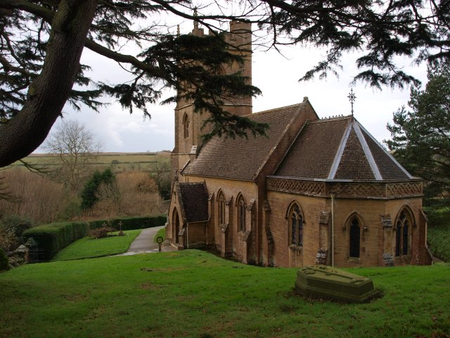
Church of St Mary, Rimpton

The Church of St Mary in Rimpton, Somerset, England was built in the early 13th century and has been designated as a Grade I listed building.The exact...

Rimpton

Rimpton is a village and civil parish 5 miles (8 km) north-west of Sherborne, and 6 miles (10 km) north-east of Yeovil on a tributary of the River Parret...

Corton Denham

Corton Denham is a village and parish in Somerset, England, situated seven miles north east of Yeovil in the South Somerset district. The village has...

St Andrew's Church, Corton Denham

St Andrew's Church is a Church of England parish church in Corton Denham, Somerset, England. It was built in 1869–70 to replace an earlier church of 13th...

Adber

Adber (formerly Eatan) is a hamlet in Dorset, England. It is known as Ateberie in the Domesday Book.Adber has no church. Its position affords fine views...

Poyntington

Poyntington is a village and civil parish in the county of Dorset in South West England. It lies on the edge of the Blackmore Vale about 2 miles (3.2 km...

Marston Magna railway station

Marston Magna railway station served the village of Marston Magna, Somerset, England from 1856 to 1966 on Heart of Wessex Line. == History == The station...

Nearby Amenities

Located within 500m of 50.982384,-2.5384116
Sandford Orcas
Is In: Dorset
Place: village
Lat/Long: 50.9845251/-2.5349567
Pub
The Mitre Inn
Addr City: Sherborne
Addr Housename: The Mitre Inn
Addr Postcode: DT9 4RU
Addr Street: Sandford Orcas
Phone: +44 1963 220271
Smoking: outside
Website: https://www.mitreinn.co.uk
Lat/Long: 50.9838498/-2.5347487
Higher Sandford
Place: locality
Lat/Long: 50.9799109/-2.532795
The Alders
Addr City: Sandford Orcas
Addr Housename: The Alders
Addr Postcode: DT9 4SB
Tourism: guest_house
Url: http://www.thealdersbb.com/
Lat/Long: 50.9864124/-2.5395156
Addr City: Sandford Orcas
Addr Housename: The Old House
Lat/Long: 50.9854167/-2.5388057
Addr City: Sandford Orcas
Addr Housename: The Old Tannery
Lat/Long: 50.9851539/-2.5388884
Addr City: Sandford Orcas
Addr Housename: Knoak House
Lat/Long: 50.9852391/-2.5386909
Addr City: Sandford Orcas
Addr Housename: The Dower House
Lat/Long: 50.9850864/-2.5391518
Addr City: Sandford Orcas
Addr Housename: Merton House
Lat/Long: 50.9851574/-2.5384991
Post Box
Mapillary: 1173574586730958
Post Box Mounting: pier
Post Box Type: lamp
Ref: DT9 43D
Survey Date: 2022-04-17
Lat/Long: 50.9850805/-2.5379329
Telephone
Booth: KX100
Covered: booth
Lat/Long: 50.9850857/-2.5379708
Defibrillator
Defibrillator Location: outside Sandford Ocras Village Hall next to phone box
Emergency: defibrillator
Indoor: no
Lat/Long: 50.9850651/-2.5378923
Addr City: Sandford Orcas
Addr Housenumber: 3
Addr Street: Farm Orchard
Lat/Long: 50.9847508/-2.5373529
Addr City: Sandford Orcas
Addr Housenumber: 4
Addr Street: Farm Orchard
Lat/Long: 50.9847106/-2.5372506
Addr City: Sandford Orcas
Addr Housenumber: 5
Addr Street: Farm Orchard
Lat/Long: 50.984664/-2.5371558
Addr City: Sandford Orcas
Addr Housenumber: 6
Addr Street: Fram Orchard
Lat/Long: 50.9846295/-2.5370654
Addr Housenumber: 2
Addr Street: Farm Orchard
Lat/Long: 50.984928/-2.5375514
Addr City: Sandford Orcas
Addr Housename: Sunniside
Addr Postcode: DT9 4RU
Lat/Long: 50.9846118/-2.5368535
Addr City: Sandford Orcas
Addr Housename: Cottage Farm
Lat/Long: 50.9844775/-2.536311
Addr City: Sandford Orcas
Addr Housename: 4 Hillside Cottages
Lat/Long: 50.9843676/-2.5360764
Addr City: Sandford Orcas
Addr Housename: 5 Hillside Cottages
Lat/Long: 50.9843358/-2.5359904
Addr City: Sandford Orcas
Addr Housename: 6 Hillside Cottages
Lat/Long: 50.9840238/-2.5346536
Addr City: Sandford Orcas
Addr Housename: 7 Hillside Cottages
Lat/Long: 50.9840217/-2.5345693
Addr City: Sandford Orcas
Addr Housename: Brookside
Lat/Long: 50.9838707/-2.5340922
Addr City: Sandford Orcas
Addr Housename: Brook House
Lat/Long: 50.9838059/-2.53364
Addr City: Sandford Orcas
Addr Housename: Old Sandford House
Addr Street: Dark Lane
Lat/Long: 50.9847084/-2.539493
Addr City: Sandford Orcas
Addr Housename: Fossil Barn
Addr Street: Manor Close
Lat/Long: 50.9845456/-2.5394874
Addr City: Sandford Orcas
Addr Housename: Jerards
Lat/Long: 50.9823987/-2.5419148
The data included in this document is from www.openstreetmap.org. The data is made available under ODbL.

Have you been to Coneygore Hill?

Leave your review of Coneygore Hill below (or comments, questions and feedback).