Sword Hill

Hill, Mountain in Cumberland Carlisle

England

Sword Hill

Moorland near Gilbert's Hill
Moorland near Gilbert's Hill Credit: Andrew Curtis

Sword Hill is a prominent geographical feature located in the region of Cumberland, England. Also known as Sword Mountain, it is part of the larger Pennine Range, which stretches across the northern part of England. Rising to an elevation of approximately 2,213 feet (675 meters), Sword Hill stands as one of the highest peaks in the region.

Situated in the Lake District National Park, Sword Hill offers breathtaking panoramic views of the surrounding landscape. Its position within the park makes it a popular destination for hikers, mountaineers, and nature enthusiasts. The hill is characterized by its rugged terrain, with steep slopes and rocky outcrops that provide a challenging yet rewarding climbing experience.

The name "Sword Hill" is derived from the shape of the hill's silhouette, which is said to resemble a sword when viewed from certain angles. This unique feature adds to the hill's allure and has made it a distinctive landmark within the region.

Sword Hill is also home to diverse flora and fauna, with heather, grasses, and mosses covering its slopes. The hill provides a habitat for various bird species, including buzzards and peregrine falcons, making it a popular spot for birdwatching.

In addition to its natural beauty, Sword Hill holds historical significance. The area surrounding the hill is dotted with ancient settlements and archaeological sites, showcasing its rich cultural heritage.

Overall, Sword Hill in Cumberland offers visitors a perfect blend of natural beauty, challenging terrain, and historical significance, making it a must-visit destination for outdoor enthusiasts and those seeking to explore the region's diverse landscapes.

If you have any feedback on the listing, please let us know in the comments section below.
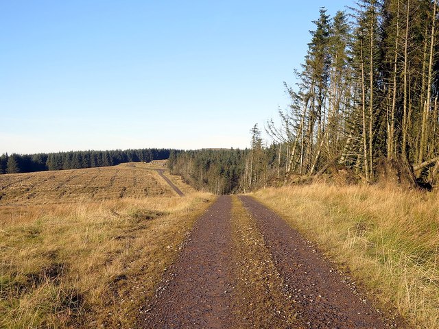
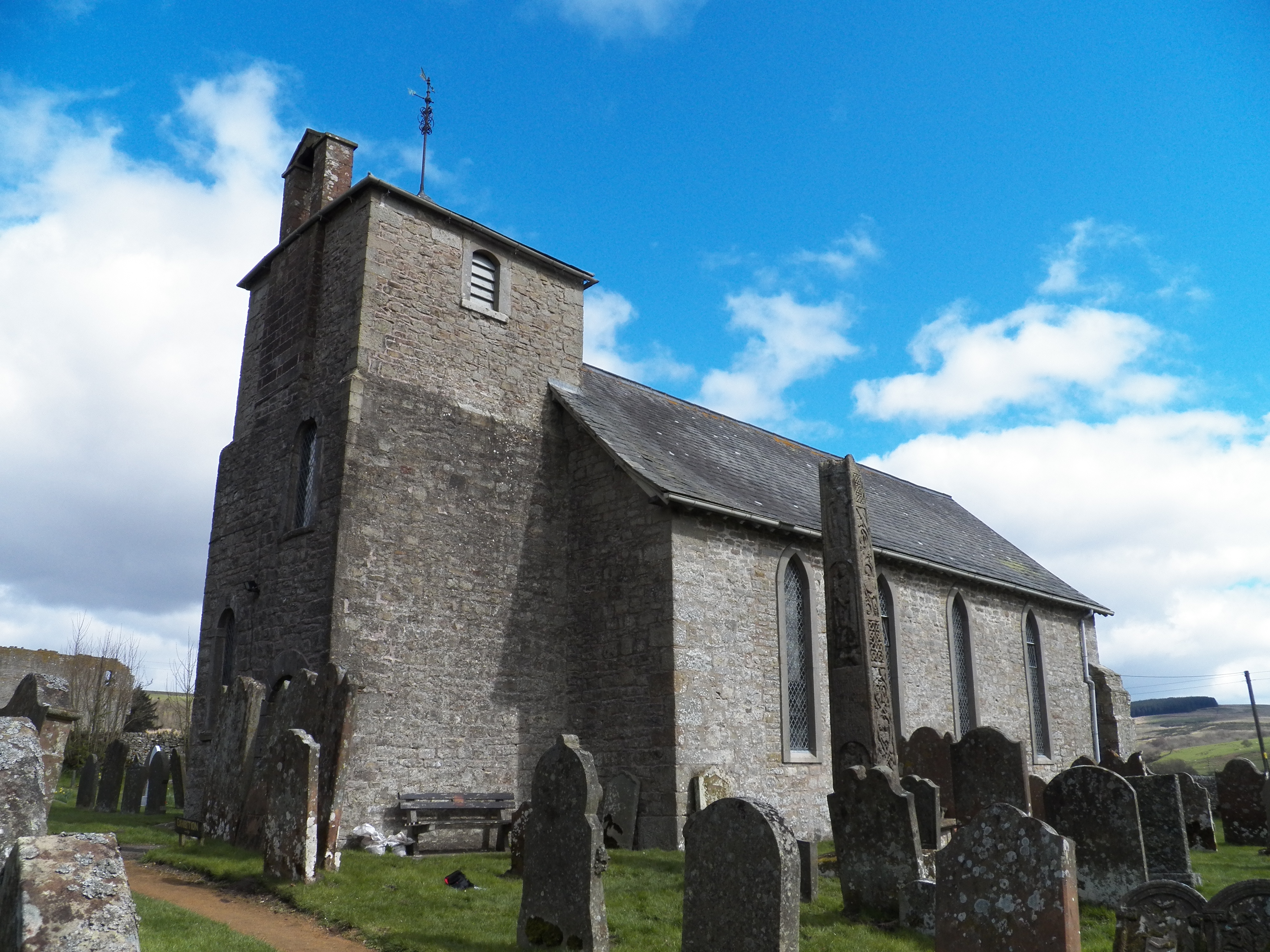
Sword Hill Images

Images are sourced within 2km of 55.07485/-2.6076987 or Grid Reference NY6175. Thanks to Geograph Open Source API. All images are credited.

Moorland near Gilbert's Hill
Crags near Barron's Pike
Large boulder at Barron's Pike Runic inscriptions were described on rock faces on Hazelgill Crag and Barron's Pike and the locations are still shown on modern maps. They were supposed to have been discovered by a shepherd, in 1872 and 1864 respectively. They were revealed in 1929 to be forgeries of the mid-19th century.

On Barron's Pike at grid reference NY59647508, close to the location shown here, there are said to be four rows of runic characters carved on the west face of a massive outcrop boulder. However, I could see nothing clearly resembling artificial markings on any of the faces of this large boulder, or on other smaller rocks in the vicinity.

The west face of the boulder <a href="https://www.geograph.org.uk/photo/5209139">NY5975 : Is this the inscribed rock at Barron's Pike?</a>, just below a major horizontal crack, does appear to be naturally 'ruled' into four equal lines, although if this location is correct, the runes themselves have disappeared, possibly through weathering.

Pastscape Monument No. 12868: <span class="nowrap"><a title="http://www.pastscape.org.uk/hob.aspx?hob_id=12868" rel="nofollow ugc noopener" href="http://www.pastscape.org.uk/hob.aspx?hob_id=12868">Link</a><img style="margin-left:2px;" alt="External link" title="External link - shift click to open in new window" src="https://s1.geograph.org.uk/img/external.png" width="10" height="10"/></span> <span class="nowrap"><a title="https://web.archive.org/web/20170223161225/http://www.pastscape.org.uk/hob.aspx?hob_id=12868" rel="nofollow ugc noopener" href="https://web.archive.org/web/20170223161225/http://www.pastscape.org.uk/hob.aspx?hob_id=12868">Archive Link</a><img style="margin-left:2px;" alt="External link" title="External link - shift click to open in new window" src="https://s1.geograph.org.uk/img/external.png" width="10" height="10"/></span>

The Runes of Bewcastle: <span class="nowrap"><a title="http://heddonhistory.weebly.com/blog/the-runes-of-bewcastle" rel="nofollow ugc noopener" href="http://heddonhistory.weebly.com/blog/the-runes-of-bewcastle">Link</a><img style="margin-left:2px;" alt="External link" title="External link - shift click to open in new window" src="https://s1.geograph.org.uk/img/external.png" width="10" height="10"/></span>
Large boulder at Barron's Pike
Runic inscriptions were described on rock faces on Hazelgill Crag and Barron's Pike and the locations are still shown on modern maps. They were supposed to have been discovered by a shepherd, in 1872 and 1864 respectively. They were revealed in 1929 to be forgeries of the mid-19th century. On Barron's Pike at grid reference NY59647508, close to the location shown here, there are said to be four rows of runic characters carved on the west face of a massive outcrop boulder. However, I could see nothing clearly resembling artificial markings on any of the faces of this large boulder, or on other smaller rocks in the vicinity. The west face of the boulder NY5975 : Is this the inscribed rock at Barron's Pike?, just below a major horizontal crack, does appear to be naturally 'ruled' into four equal lines, although if this location is correct, the runes themselves have disappeared, possibly through weathering. Pastscape Monument No. 12868: LinkExternal link Archive LinkExternal link The Runes of Bewcastle: LinkExternal link
Is this the inscribed rock at Barron's Pike? I am wondering if the (fake) runic inscription recorded on at the west face of a massive boulder at Barron's Pike could have been on the boulder shown in the centre of this photo. Four lines of runic script were described and could have been on the part of the flat surface directly below the horizontal crack. However, I could see no evidence of inscribed lines which may have been eroded away although might be detectable in ideal light conditions or by rubbing. See description here <a href="https://www.geograph.org.uk/photo/5209087">NY5975 : Large boulder at Barron's Pike</a>

Update from January 2018:
An email correspondent from the Bewcastle area recently sent me a very fine photo showing the boulder and the runic inscriptions. From their photo it is apparent that the carved boulder is not the one shown here in the foreground but that just to its right along the slope, with the pointed top. The inscriptions are on the surface, in deep shadow in my photo, just below the point.

The Runes of Bewcastle: <span class="nowrap"><a title="http://heddonhistory.weebly.com/blog/the-runes-of-bewcastle" rel="nofollow ugc noopener" href="http://heddonhistory.weebly.com/blog/the-runes-of-bewcastle">Link</a><img style="margin-left:2px;" alt="External link" title="External link - shift click to open in new window" src="https://s1.geograph.org.uk/img/external.png" width="10" height="10"/></span>
Is this the inscribed rock at Barron's Pike?
I am wondering if the (fake) runic inscription recorded on at the west face of a massive boulder at Barron's Pike could have been on the boulder shown in the centre of this photo. Four lines of runic script were described and could have been on the part of the flat surface directly below the horizontal crack. However, I could see no evidence of inscribed lines which may have been eroded away although might be detectable in ideal light conditions or by rubbing. See description here NY5975 : Large boulder at Barron's Pike Update from January 2018: An email correspondent from the Bewcastle area recently sent me a very fine photo showing the boulder and the runic inscriptions. From their photo it is apparent that the carved boulder is not the one shown here in the foreground but that just to its right along the slope, with the pointed top. The inscriptions are on the surface, in deep shadow in my photo, just below the point. The Runes of Bewcastle: LinkExternal link
Side Fell west of Barron's Pike The wall running down the slope separates heather moorland (left) from a recently clear-felled forest plantation (right). The location is close to the Roman Signal Station on Barron's Pike, close to the forest on the right side of the wall just above the photographer. It was built to have a view down to the Roman Fort in Bewcastle.
Side Fell west of Barron's Pike
The wall running down the slope separates heather moorland (left) from a recently clear-felled forest plantation (right). The location is close to the Roman Signal Station on Barron's Pike, close to the forest on the right side of the wall just above the photographer. It was built to have a view down to the Roman Fort in Bewcastle.
Barron's Pike View towards Spadeadam.
Barron's Pike
View towards Spadeadam.
Earthworks at Barron's Pike Earthwork remains now considered to be of a Roman Signal Station although previously described as a ditched bowl barrow (tumulus). In 1989, a section was cut across the ditch which was shown to be cut through rock and of a typical  V-shaped Roman military plan, 2.70m wide by 1.10m deep. The ditch is crossed by a turf-covered causeway, 2.0m wide, situated on the west side and visible in the foreground of this photo. The enclosure is of oval to sub-rectangular shape, about 17m by 12m, and surrounds a flat earthen platform.  
Pastscape: <span class="nowrap"><a title="http://www.pastscape.org.uk/hob.aspx?hob_id=12871" rel="nofollow ugc noopener" href="http://www.pastscape.org.uk/hob.aspx?hob_id=12871">Link</a><img style="margin-left:2px;" alt="External link" title="External link - shift click to open in new window" src="https://s1.geograph.org.uk/img/external.png" width="10" height="10"/></span> <span class="nowrap"><a title="https://web.archive.org/web/20170222180557/http://www.pastscape.org.uk/hob.aspx?hob_id=12871" rel="nofollow ugc noopener" href="https://web.archive.org/web/20170222180557/http://www.pastscape.org.uk/hob.aspx?hob_id=12871">Archive Link</a><img style="margin-left:2px;" alt="External link" title="External link - shift click to open in new window" src="https://s1.geograph.org.uk/img/external.png" width="10" height="10"/></span>
Earthworks at Barron's Pike
Earthwork remains now considered to be of a Roman Signal Station although previously described as a ditched bowl barrow (tumulus). In 1989, a section was cut across the ditch which was shown to be cut through rock and of a typical V-shaped Roman military plan, 2.70m wide by 1.10m deep. The ditch is crossed by a turf-covered causeway, 2.0m wide, situated on the west side and visible in the foreground of this photo. The enclosure is of oval to sub-rectangular shape, about 17m by 12m, and surrounds a flat earthen platform. Pastscape: LinkExternal link Archive LinkExternal link
Warning notice by track into Spadeadam A second notice has been added to the 'Prohibited Place' sign <a href="https://www.geograph.org.uk/photo/827500">NY5975 : Track entering RAF Spadeadam</a>. It explicitly warns of military (and agricultural) vehicles, sudden loud noise, lasers, troop training, low flying aircraft, and, worse of all, deer!

A radar tower located at the Spadeadam site on Greymare Hill is just visible on the centre skyline <a href="https://www.geograph.org.uk/photo/825951">NY6174 : Tower, Spadeadam Forest</a>

RAF Spadeadam is the home of the 9000 acre Electronic Warfare Tactics Range. The Norwegian firm, DNV GL, also uses the site for industrial hazard testing, including fire and the destruction of pipelines. Two loud explosions which echoed around the hills while I was in this area were probably this more benign industrial testing.
Warning notice by track into Spadeadam
A second notice has been added to the 'Prohibited Place' sign NY5975 : Track entering RAF Spadeadam. It explicitly warns of military (and agricultural) vehicles, sudden loud noise, lasers, troop training, low flying aircraft, and, worse of all, deer! A radar tower located at the Spadeadam site on Greymare Hill is just visible on the centre skyline NY6174 : Tower, Spadeadam Forest RAF Spadeadam is the home of the 9000 acre Electronic Warfare Tactics Range. The Norwegian firm, DNV GL, also uses the site for industrial hazard testing, including fire and the destruction of pipelines. Two loud explosions which echoed around the hills while I was in this area were probably this more benign industrial testing.
Forest track near Barron's Pike Looking north-west towards Hazelgill Crag.
Forest track near Barron's Pike
Looking north-west towards Hazelgill Crag.
Forest track near Hazelgill Crag View south-east towards Barron's Pike.
Forest track near Hazelgill Crag
View south-east towards Barron's Pike.
Hazelgill Crag Hazelgill Crags is a second location in the area for a rock inscribed with runes. The other is at Barron's Pike <a href="https://www.geograph.org.uk/photo/5209139">NY5975 : Is this the inscribed rock at Barron's Pike?</a>. They were supposed to have been discovered by a shepherd, in 1872 and 1864 respectively. They are believed to be forgeries of the mid-19th century. 

At Hazelgill Crags, the inscription, comprising one row of characters, is described as being visible on the north-west face of a cleft in the natural rock outcrop.

A large quarry has been opened up behind the crags <a href="https://www.geograph.org.uk/photo/5211147">NY5976 : Quarry at Hazelgill Crag</a>
Hazelgill Crag
Hazelgill Crags is a second location in the area for a rock inscribed with runes. The other is at Barron's Pike NY5975 : Is this the inscribed rock at Barron's Pike?. They were supposed to have been discovered by a shepherd, in 1872 and 1864 respectively. They are believed to be forgeries of the mid-19th century. At Hazelgill Crags, the inscription, comprising one row of characters, is described as being visible on the north-west face of a cleft in the natural rock outcrop. A large quarry has been opened up behind the crags NY5976 : Quarry at Hazelgill Crag
Quarry at Hazelgill Crag
Forest at Bullcleugh Gate
Disused quarry near Bullcleugh Gate
RAF Spadeadam - Greymare Hill There are two Blue Streak rocket test beds. This is the more westerly one.
RAF Spadeadam - Greymare Hill
There are two Blue Streak rocket test beds. This is the more westerly one.
RAF Spadeadam - Greymare Hill The easterly of the two Blue Streak rocket test beds.
RAF Spadeadam - Greymare Hill
The easterly of the two Blue Streak rocket test beds.
RAF Spadeadam - Greymare Hill The more easterly of two Blue Streak rocket test beds.
RAF Spadeadam - Greymare Hill
The more easterly of two Blue Streak rocket test beds.
RAF Spadeadam - Greymare Hill A view of the more easterly of two Blue Streak rocket test beds.
RAF Spadeadam - Greymare Hill
A view of the more easterly of two Blue Streak rocket test beds.
Show me another place!

Sword Hill is located at Grid Ref: NY6175 (Lat: 55.07485, Lng: -2.6076987)

Administrative County: Cumbria

District: Carlisle

Police Authority: Cumbria

What 3 Words

///etchings.clinic.shampoo. Near Greenhead, Northumberland

Nearby Locations

Sword Hill

Related Wikis

Kingwater

Kingwater is a civil parish in City of Carlisle district, Cumbria, England. At the 2011 census it had a population of 170.The parish is bordered to the...

Bewcastle Castle

Bewcastle Castle is a ruined castle in the parish of Bewcastle in the English county of Cumbria, a few miles from the Scottish border. == History == The...

Bewcastle Cross

The Bewcastle Cross is an Anglo-Saxon cross which is still in its original position within the churchyard of St Cuthbert's church at Bewcastle, in the...

Bewcastle

Bewcastle is a large civil parish in the Cumberland unitary authority area of Cumbria, England. It is in the historic county of Cumberland. According to...

Nearby Amenities

Located within 500m of 55.07485,-2.6076987
Gowany Hill
Place: locality
Lat/Long: 55.0785939/-2.6111049
Sword Hill
Place: locality
Lat/Long: 55.0754804/-2.6072315
The data included in this document is from www.openstreetmap.org. The data is made available under ODbL.

Have you been to Sword Hill?

Leave your review of Sword Hill below (or comments, questions and feedback).