Black Stantling
Hill, Mountain in Cumberland Carlisle
England
Black Stantling

Black Stantling is a prominent hill located in the Cumberland region of England. Standing at an elevation of approximately 1,522 feet (464 meters), it is considered one of the highest peaks in the area. The hill is situated within the Lake District National Park, a renowned destination for outdoor enthusiasts and nature lovers.
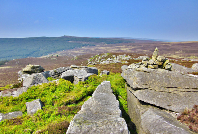
The name "Black Stantling" is derived from the Old Norse word "staðr," meaning a place or location. The hill is characterized by its dark and rugged appearance, with rocky outcrops and steep slopes covered by heather and grass. Its distinctive silhouette makes it a notable landmark in the region.
Black Stantling offers breathtaking panoramic views of the surrounding countryside, including the picturesque valleys, rolling hills, and shimmering lakes that the Lake District is famous for. On a clear day, visitors can enjoy vistas stretching as far as the eye can see, with mountains such as Skiddaw and Blencathra visible in the distance.
The hill provides an array of opportunities for outdoor activities such as hiking, walking, and photography. Numerous trails traverse its slopes, catering to different fitness levels and preferences. The ascent to the summit may be challenging, but the reward of reaching the top is unparalleled. It is not uncommon to encounter wildlife such as birds, sheep, and occasionally even deer during the climb.
Overall, Black Stantling is a beloved natural landmark in the Cumberland region, offering visitors a chance to immerse themselves in the stunning beauty of the Lake District and experience the sense of tranquility and awe that this remarkable location provides.
If you have any feedback on the listing, please let us know in the comments section below.
Black Stantling Images
Images are sourced within 2km of 55.109607/-2.6292468 or Grid Reference NY5979. Thanks to Geograph Open Source API. All images are credited.


Black Stantling is located at Grid Ref: NY5979 (Lat: 55.109607, Lng: -2.6292468)
Administrative County: Cumbria
District: Carlisle
Police Authority: Cumbria
What 3 Words
///something.relishing.partners. Near Greenhead, Northumberland
Nearby Locations
Related Wikis

Sighty Crag
Sighty Crag is a hill in the southern part of the Kielder Forest region in northern England, a region which also includes its fellow Marilyns of Peel Fell...

Bewcastle Castle
Bewcastle Castle is a ruined castle in the parish of Bewcastle in the English county of Cumbria, a few miles from the Scottish border. == History == The...

Bewcastle Cross
The Bewcastle Cross is an Anglo-Saxon cross which is still in its original position within the churchyard of St Cuthbert's church at Bewcastle, in the...

Bewcastle Roman Fort
Bewcastle Roman Fort was built to the north of Hadrian's Wall as an outpost fort possibly intended for scouting and intelligence. The remains of the fort...
Nearby Amenities
Located within 500m of 55.109607,-2.6292468Have you been to Black Stantling?
Leave your review of Black Stantling below (or comments, questions and feedback).