Insworke

Settlement in Cornwall

England

Insworke

View from Maker towards Millbrook Photo taken during the never ending 2018 heatwave, hence all the yellow grass!
View from Maker towards Millbrook Credit: Charli

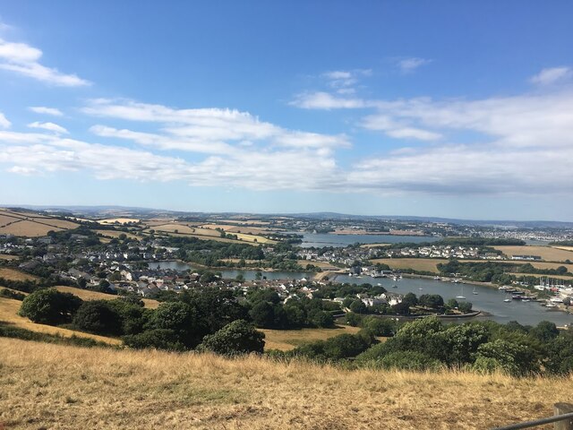
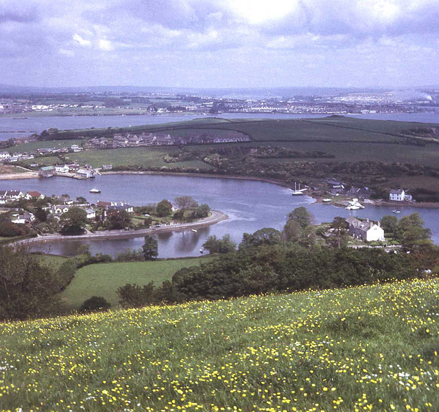
Insworke is a small coastal village located in the county of Cornwall, England. Situated along the picturesque coastline, it is known for its stunning natural beauty and rich history. With a population of around 500 residents, Insworke offers a peaceful and tranquil environment for both locals and visitors.

The village is characterized by its charming old cottages made of local stone, which add to its traditional and rustic appeal. Surrounded by rolling hills and lush green fields, Insworke offers breathtaking views of the Cornish countryside. Its proximity to the coast also means that visitors can enjoy long walks along the sandy beaches or explore the rocky cliffs that dot the shoreline.

Insworke is also famous for its historical landmarks. The village is home to a medieval church, St. Michael's, which is a significant architectural gem. The church showcases stunning stained-glass windows and intricate stone carvings, attracting history enthusiasts from all over.

For those seeking outdoor activities, Insworke provides ample opportunities for hiking, cycling, and fishing. The nearby Insworke Bay is a popular spot for water sports enthusiasts, offering activities such as surfing and kayaking.

Insworke has a close-knit community that takes pride in its local traditions and culture. The village hosts various events throughout the year, including a summer fair and a Christmas market, which bring residents together and attract visitors from neighboring areas.

Overall, Insworke is a picturesque village that offers a perfect blend of natural beauty, historical significance, and community spirit, making it a delightful destination for those seeking a peaceful getaway in Cornwall.

If you have any feedback on the listing, please let us know in the comments section below.

Insworke Images

Images are sourced within 2km of 50.352682/-4.209594 or Grid Reference SX4252. Thanks to Geograph Open Source API. All images are credited.

View from Maker towards Millbrook Photo taken during the never ending 2018 heatwave, hence all the yellow grass!
View from Maker towards Millbrook
Photo taken during the never ending 2018 heatwave, hence all the yellow grass!
View N at Treninnow towards St John's Lake & Plymouth
Radford Ln leading to West St, Millbrook
Military Pillbox A disused military pillbox used during World War 2.
Military Pillbox
A disused military pillbox used during World War 2.
Old windmill at Empacombe This round tower is believed to be the remains of a windmill.  In the background, across Millbrook Lake is Southdown.
Old windmill at Empacombe
This round tower is believed to be the remains of a windmill. In the background, across Millbrook Lake is Southdown.
Maker Church and War Memorial
Fortification on Maker Heights The Rame Peninsula is littered with old fortifications and gun emplacements.  Here on Maker heights, overlooking Cawsand Bay they are most dense.  Most of these are covered with trees and bushes but occasionally a wall or buttress pokes out such as the one show in the photograph which was probably part of a gun emplacement from Napoleonic times.
Fortification on Maker Heights
The Rame Peninsula is littered with old fortifications and gun emplacements. Here on Maker heights, overlooking Cawsand Bay they are most dense. Most of these are covered with trees and bushes but occasionally a wall or buttress pokes out such as the one show in the photograph which was probably part of a gun emplacement from Napoleonic times.
Millbrook This photograph was taken from the viewpoint on Maker Heights overlooking the village (SX430516)
Millbrook
This photograph was taken from the viewpoint on Maker Heights overlooking the village (SX430516)
Fourlanesend School This is the local primary school for the Rame Peninsula.  The name comes from its situation on the high ground between Kingsand/Cawsand and Millbrook at the junction of four (or five?) lanes.
Fourlanesend School
This is the local primary school for the Rame Peninsula. The name comes from its situation on the high ground between Kingsand/Cawsand and Millbrook at the junction of four (or five?) lanes.
Tregonhawke A farm in the valley bottom.
Tregonhawke
A farm in the valley bottom.
Freshwater Lake, Millbrook The upper end of the tidal creek leading to Millbrook was dammed producing this pleasant freshwater lake.
Freshwater Lake, Millbrook
The upper end of the tidal creek leading to Millbrook was dammed producing this pleasant freshwater lake.
Street scene in Millbrook village
Boatyards at Southdown on the Insworke peninsula
Southdown on the Insworke Peninsula This photograph was taken from the viewpoint on Maker Heights at SX430515.  It looks very pretty with the tide in but when the tide is out - which is most of the time - almost all the foreground water is mud flats.  In the background is the River Tamar and Devonport Dockyard.
Southdown on the Insworke Peninsula
This photograph was taken from the viewpoint on Maker Heights at SX430515. It looks very pretty with the tide in but when the tide is out - which is most of the time - almost all the foreground water is mud flats. In the background is the River Tamar and Devonport Dockyard.
Millbrook Business Park Situated high on the hill above the village of Millbrook and surrounded by green fields, these workshops have been provided in an attempt to create local employment for local people and were financed by European Union "Objective One" funds.
Millbrook Business Park
Situated high on the hill above the village of Millbrook and surrounded by green fields, these workshops have been provided in an attempt to create local employment for local people and were financed by European Union "Objective One" funds.
Penhale, near St John Looking down the valley to the hamlet of Penhale.  Beyond the boundaries of this square in the distance is the River Tamar and Plymouth
Penhale, near St John
Looking down the valley to the hamlet of Penhale. Beyond the boundaries of this square in the distance is the River Tamar and Plymouth
On the Path to Hooe Lake Valley
Anderton and Millbrook Lake
Show me another place!

Insworke is located at Grid Ref: SX4252 (Lat: 50.352682, Lng: -4.209594)

Unitary Authority: Cornwall

Police Authority: Devon and Cornwall

What 3 Words

///breached.restores.blending. Near Millbrook, Cornwall

Related Wikis

Southdown, Cornwall

Southdown is a coastal village in south-east Cornwall, England, United Kingdom. It is situated on the banks of the Hamoaze east of Millbrook on the Rame...

Insworke

Insworke is a hamlet in the parish of Millbrook (before 1869 in the parish of Maker) in southeast Cornwall, England, UK. A fair and annual market were...

Millbrook A.F.C.

Millbrook Association Football Club is a football club based in Millbrook, Cornwall, England. They are currently members of the Western League Premier...

All Saints Church, Millbrook

All Saints Church is a Church of England parish church in Millbrook, Cornwall, England, UK. It was built in 1893–95 and has been Grade II listed since...

Anderton, Cornwall

Anderton is a settlement in south-east Cornwall, England, United Kingdom, located at grid reference SW 431 519. There are also places called Anderton in...

Millbrook, Cornwall

Millbrook (Cornish: Govermelin) is a civil parish and village in southeast Cornwall, England, United Kingdom. The village is situated on the Rame Peninsula...
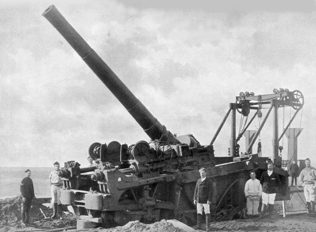
Hawkins Battery

Hawkins Battery is a former coastal artillery battery, built to defend the Royal Naval Dockyard at Devonport. The battery was originally built between...

Maker, Cornwall

Maker (Cornish: Magor) is a village between Cawsand and Rame Head, Rame Peninsula, Cornwall, England, United Kingdom. The name means a ruin or old wall...

Nearby Amenities

Located within 500m of 50.352682,-4.209594
Source: PGS
Lat/Long: 50.3488806/-4.2085161
Source: PGS
Lat/Long: 50.3491073/-4.2089366
Source: PGS
Lat/Long: 50.3492231/-4.2093204
Source: PGS
Lat/Long: 50.3495408/-4.2097034
Source: PGS
Lat/Long: 50.3495162/-4.2099445
Source: PGS
Lat/Long: 50.3504807/-4.2100892
Source: PGS
Lat/Long: 50.3506277/-4.2097128
Source: PGS
Lat/Long: 50.3508196/-4.2095546
Source: PGS
Lat/Long: 50.3507217/-4.2092896
Source: PGS
Lat/Long: 50.3504891/-4.2090322
Source: PGS
Lat/Long: 50.3506737/-4.2090133
Source: PGS
Lat/Long: 50.3509007/-4.2086638
Source: PGS
Lat/Long: 50.3510437/-4.2082543
Source: PGS
Lat/Long: 50.3504662/-4.2064264
Source: PGS
Lat/Long: 50.3499366/-4.2058478
Source: PGS
Lat/Long: 50.3496375/-4.2058227
Source: PGS
Lat/Long: 50.3494085/-4.2057266
Source: PGS
Lat/Long: 50.3490964/-4.2056322
Source: PGS
Lat/Long: 50.3561211/-4.2124849
Source: PGS
Lat/Long: 50.3557387/-4.2124112
Source: PGS
Lat/Long: 50.3552346/-4.2121287
Source: PGS
Lat/Long: 50.354955/-4.2118202
Source: PGS
Lat/Long: 50.3546227/-4.2121821
Source: PGS
Lat/Long: 50.3546641/-4.2124639
Source: PGS
Lat/Long: 50.3545342/-4.2128459
Source: PGS
Lat/Long: 50.3542905/-4.2133027
Source: PGS
Lat/Long: 50.3545809/-4.213588
Source: PGS
Lat/Long: 50.3549902/-4.2140835
Source: PGS
Lat/Long: 50.3549677/-4.2145899
Source: PGS
Lat/Long: 50.3554064/-4.2144826
Source: PGS
Lat/Long: 50.3557627/-4.2147181
Mini Roundabout
Direction: clockwise
Lat/Long: 50.3519653/-4.2139506
Bus Stop
Insworke Quay
Naptan AtcoCode: 0800FWX38761
Naptan Bearing: W
Naptan CommonName: Insworke Quay
Naptan NaptanCode: corgajdm
Naptan Street: Southdown Road
Naptan Verified: no
Source: naptan_import
Lat/Long: 50.3533039/-4.2027105
Leisure: picnic_table
Lat/Long: 50.3491645/-4.2137668
Bench
Lat/Long: 50.3489154/-4.2122886
Bench
Lat/Long: 50.3489169/-4.2110338
Bench
Lat/Long: 50.3492235/-4.2104677
Generator Method: photovoltaic
Generator Output Electricity: yes
Generator Source: solar
Generator Type: solar_photovoltaic_panel
Location: roof
Power: generator
Lat/Long: 50.3484515/-4.208081
Generator Method: photovoltaic
Generator Output Electricity: yes
Generator Source: solar
Generator Type: solar_photovoltaic_panel
Location: roof
Power: generator
Lat/Long: 50.3529432/-4.2058317
Generator Method: photovoltaic
Generator Output Electricity: yes
Generator Source: solar
Generator Type: solar_photovoltaic_panel
Location: roof
Power: generator
Lat/Long: 50.3528668/-4.2066702
Generator Method: photovoltaic
Generator Output Electricity: yes
Generator Source: solar
Generator Type: solar_photovoltaic_panel
Location: roof
Power: generator
Lat/Long: 50.3529427/-4.2055558
Generator Method: photovoltaic
Generator Output Electricity: yes
Generator Source: solar
Generator Type: solar_photovoltaic_panel
Location: roof
Power: generator
Lat/Long: 50.3529018/-4.2099617
Generator Method: photovoltaic
Generator Output Electricity: yes
Generator Source: solar
Generator Type: solar_photovoltaic_panel
Location: roof
Power: generator
Lat/Long: 50.3529446/-4.2056458
Generator Method: photovoltaic
Generator Output Electricity: yes
Generator Source: solar
Generator Type: solar_photovoltaic_panel
Location: roof
Power: generator
Lat/Long: 50.3529675/-4.2054686
Generator Method: photovoltaic
Generator Output Electricity: yes
Generator Source: solar
Generator Type: solar_photovoltaic_panel
Location: roof
Power: generator
Lat/Long: 50.3529344/-4.2080446
Generator Method: photovoltaic
Generator Output Electricity: yes
Generator Source: solar
Generator Type: solar_photovoltaic_panel
Location: roof
Power: generator
Lat/Long: 50.3524148/-4.2120974
Generator Method: photovoltaic
Generator Output Electricity: yes
Generator Source: solar
Generator Type: solar_photovoltaic_panel
Location: roof
Power: generator
Lat/Long: 50.3533395/-4.2108413
Generator Method: photovoltaic
Generator Output Electricity: yes
Generator Source: solar
Generator Type: solar_photovoltaic_panel
Location: roof
Power: generator
Lat/Long: 50.352945/-4.2060068
Generator Method: photovoltaic
Generator Output Electricity: yes
Generator Source: solar
Generator Type: solar_photovoltaic_panel
Location: roof
Power: generator
Lat/Long: 50.3537613/-4.2084545
Generator Method: photovoltaic
Generator Output Electricity: yes
Generator Source: solar
Generator Type: solar_photovoltaic_panel
Location: roof
Power: generator
Lat/Long: 50.3529365/-4.2057388
Generator Method: photovoltaic
Generator Output Electricity: yes
Generator Source: solar
Generator Type: solar_photovoltaic_panel
Location: roof
Power: generator
Lat/Long: 50.3528802/-4.2068066
Generator Method: photovoltaic
Generator Output Electricity: yes
Generator Source: solar
Generator Type: solar_photovoltaic_panel
Location: roof
Power: generator
Lat/Long: 50.3529473/-4.2059196
Generator Method: photovoltaic
Generator Output Electricity: yes
Generator Source: solar
Generator Type: solar_photovoltaic_panel
Location: roof
Power: generator
Lat/Long: 50.3529643/-4.2053742
Generator Method: photovoltaic
Generator Output Electricity: yes
Generator Source: solar
Generator Type: solar_photovoltaic_panel
Location: roof
Power: generator
Lat/Long: 50.3535471/-4.208778
Generator Method: photovoltaic
Generator Output Electricity: yes
Generator Source: solar
Generator Type: solar_photovoltaic_panel
Location: roof
Power: generator
Lat/Long: 50.352645/-4.2127851
Generator Method: photovoltaic
Generator Output Electricity: yes
Generator Source: solar
Generator Type: solar_photovoltaic_panel
Location: roof
Power: generator
Lat/Long: 50.3530114/-4.2075082
Generator Method: photovoltaic
Generator Output Electricity: yes
Generator Source: solar
Generator Type: solar_photovoltaic_panel
Location: roof
Power: generator
Lat/Long: 50.3536016/-4.2107867
Generator Method: photovoltaic
Generator Output Electricity: yes
Generator Source: solar
Generator Type: solar_photovoltaic_panel
Location: roof
Power: generator
Lat/Long: 50.3531142/-4.2114781
Generator Method: photovoltaic
Generator Output Electricity: yes
Generator Source: solar
Generator Type: solar_photovoltaic_panel
Location: roof
Power: generator
Lat/Long: 50.3535742/-4.210709
Generator Method: photovoltaic
Generator Output Electricity: yes
Generator Source: solar
Generator Type: solar_photovoltaic_panel
Location: roof
Power: generator
Lat/Long: 50.3539644/-4.2106017
Generator Method: photovoltaic
Generator Output Electricity: yes
Generator Source: solar
Generator Type: solar_photovoltaic_panel
Location: roof
Power: generator
Lat/Long: 50.3529602/-4.2103073
Generator Method: photovoltaic
Generator Output Electricity: yes
Generator Source: solar
Generator Type: solar_photovoltaic_panel
Location: roof
Power: generator
Lat/Long: 50.3529157/-4.2106346
Generator Method: photovoltaic
Generator Output Electricity: yes
Generator Source: solar
Generator Type: solar_photovoltaic_panel
Location: roof
Power: generator
Lat/Long: 50.3522012/-4.2142301
Generator Method: photovoltaic
Generator Output Electricity: yes
Generator Source: solar
Generator Type: solar_photovoltaic_panel
Location: roof
Power: generator
Lat/Long: 50.3483918/-4.2095771
Power: pole
Lat/Long: 50.3517915/-4.2064239
Power: pole
Lat/Long: 50.3508981/-4.2056716
Power: pole
Lat/Long: 50.3514594/-4.2028311
Power: pole
Lat/Long: 50.3514731/-4.2039925
Power: pole
Lat/Long: 50.3514971/-4.2051713
Power: pole
Lat/Long: 50.3515031/-4.2063166
Power: pole
Lat/Long: 50.3515031/-4.2075612
Power: pole
Lat/Long: 50.3518633/-4.2087293
Power: pole
Lat/Long: 50.3522082/-4.2099135
Post Box
Brand: Royal Mail
Brand Wikidata: Q638098
Brand Wikipedia: en:Royal Mail
Collection Times: Mo-Fr 09:00; Sa 07:00; Su off
Operator: Royal Mail
Operator Wikidata: Q638098
Post Box Design: type_c
Post Box Mounting: brick_wall
Post Box Type: wall
Ref: PL10 651D
Royal Cypher: GR
Royal Cypher Wikidata: Q33102273
Source: survey;streetlevel imagery;aerial imagery
Lat/Long: 50.3520715/-4.213969
Post Box
Brand: Royal Mail
Brand Wikidata: Q638098
Brand Wikipedia: en:Royal Mail
Collection Times: Mo-Sa 09:30; Su off
Operator: Royal Mail
Operator Wikidata: Q638098
Post Box Design: type_b
Post Box Mounting: brick_pillar
Post Box Type: wall
Ref: PL10 763
Royal Cypher: GVIR
Royal Cypher Wikidata: Q33102169
Source: survey;streetlevel imagery;aerial imagery
Lat/Long: 50.3533368/-4.208193
The data included in this document is from www.openstreetmap.org. The data is made available under ODbL.

Have you been to Insworke?

Leave your review of Insworke below (or comments, questions and feedback).