Bowland's Hill

Hill, Mountain in Westmorland South Lakeland

England

Bowland's Hill

Beck Docker Bridge Enters the River Mint before it leaves the square
Beck Docker Bridge Credit: Michael Graham

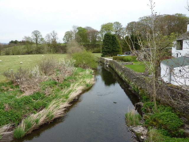
Bowland's Hill, located in Westmorland, is a prominent hill that stands tall in the picturesque landscape of the English Lake District. With an elevation of 1,280 feet (390 meters), it offers breathtaking panoramic views of the surrounding countryside.

Situated on the edge of the village of Ings, Bowland's Hill is part of the larger Bowland Fells range in the Lake District National Park. It is a popular destination for hikers and nature enthusiasts, drawing visitors from near and far.

The hill is characterized by its gentle slopes and lush greenery, covered in a patchwork of meadows, woodlands, and grazing fields. The diverse vegetation supports a wide array of flora and fauna, making it an ideal spot for birdwatching and wildlife spotting.

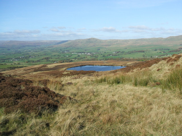
At the summit, visitors are rewarded with stunning vistas of the neighboring peaks, lakes, and valleys. On clear days, it is possible to see as far as the Yorkshire Dales and Morecambe Bay. The hill's strategic location and its unspoiled natural beauty make it a favorite spot for photographers and artists seeking inspiration.

Bowland's Hill is easily accessible by foot, with several well-marked trails leading to the summit. The surrounding area also offers numerous amenities, including parking facilities, picnic spots, and nearby accommodation options. Whether one seeks a challenging hike or a leisurely stroll, Bowland's Hill promises a memorable experience for all who venture to its heights.

If you have any feedback on the listing, please let us know in the comments section below.

Bowland's Hill Images

Images are sourced within 2km of 54.368616/-2.6530004 or Grid Reference SD5797. Thanks to Geograph Open Source API. All images are credited.

Beck Docker Bridge Enters the River Mint before it leaves the square
Beck Docker Bridge
Enters the River Mint before it leaves the square
St. John's Church Grayrigg On the road to Tebay from Kendal
St. John's Church Grayrigg
On the road to Tebay from Kendal
Looking towards Whinfell From the A 685 outside Greyrigg
Looking towards Whinfell
From the A 685 outside Greyrigg
Hyning Farm entrance and cattle grid
Hyning
Farm entrance and cattle grid
Wall and Fence On the road to Docker. Whinfell Beacon in shot.
Wall and Fence
On the road to Docker. Whinfell Beacon in shot.
Patton Bridge Over the River Mint
Patton Bridge
Over the River Mint
The Joys of the Single Track Road Go for the ones with grass down the middle. Near Patton Bridge
The Joys of the Single Track Road
Go for the ones with grass down the middle. Near Patton Bridge
Whinhowe Gill Surprisingly desert like on the hottest day of the year so far.
Whinhowe Gill
Surprisingly desert like on the hottest day of the year so far.
Sheep Sheep NE of The Borrans with Moorbank Farm in the distance
Sheep
Sheep NE of The Borrans with Moorbank Farm in the distance
Gate Just N of The Borrans on the way to Howestone.
Gate
Just N of The Borrans on the way to Howestone.
Sheep South of Grayrigg on the road to Beck Houses
Sheep
South of Grayrigg on the road to Beck Houses
Beckhouses plus cat
Beckhouses plus cat
Stream at Beck Houses
Old gateway plus spare gate
Sheep Feeding time for the sheep, opposite the entrance to Morsedale Hall
Sheep
Feeding time for the sheep, opposite the entrance to Morsedale Hall
Brand new gate New gate at the Lodge to Morsedale Hall
Brand new gate
New gate at the Lodge to Morsedale Hall
Interior of St John the Evangelist Church Grayrigg
St John the Evangelist Church, Grayrigg
Show me another place!

Bowland's Hill is located at Grid Ref: SD5797 (Lat: 54.368616, Lng: -2.6530004)

Administrative County: Cumbria

District: South Lakeland

Police Authority: Cumbria

What 3 Words

///open.dial.dunk. Near Burneside, Cumbria

Related Wikis

Grayrigg

Grayrigg is a small village and civil parish in the South Lakeland district of Cumbria, England. In the 2001 census the parish had a population of 223...
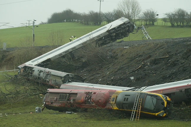
Grayrigg derailment

The Grayrigg derailment was a fatal railway accident that occurred at approximately 20:15 GMT on 23 February 2007, just to the south of Grayrigg, Cumbria...

Docker, Cumbria

Docker is a civil parish in the South Lakeland district of the English county of Cumbria. Docker is 4.3 miles north east of the market town of Kendal....

Whinfell

Whinfell is a civil parish in South Lakeland, Cumbria, England. It does not have a parish council but a parish meeting. The parish lies north east of Kendal...

Patton Bridge

Patton Bridge is a small rural hamlet approximately 5 miles from the outskirts of Kendal, Cumbria, England. Its post code region is LA8.

Beck Houses

Beck Houses is a village in Cumbria, England.

Lambrigg

Lambrigg is a civil parish in the South Lakeland district of the English county of Cumbria. It includes the hamlets of Cross Houses and Lambrigg Head...

Grayrigg railway station

Grayrigg railway station in Lambrigg parish, was situated on the course of the original Lancaster and Carlisle Railway (L&CR) (the West Coast Main Line...

Nearby Amenities

Located within 500m of 54.368616,-2.6530004
Created By: Merkaartor 0.13
Lat/Long: 54.3683768/-2.6486575
Created By: Merkaartor 0.13
Lat/Long: 54.3681989/-2.6487444
Created By: Merkaartor 0.13
Lat/Long: 54.3680432/-2.6488686
Created By: Merkaartor 0.13
Lat/Long: 54.3678209/-2.6488437
Created By: Merkaartor 0.13
Lat/Long: 54.3675763/-2.6486947
Created By: Merkaartor 0.13
Lat/Long: 54.367213/-2.6483968
Created By: Merkaartor 0.13
Lat/Long: 54.3669981/-2.6481734
Created By: Merkaartor 0.13
Lat/Long: 54.3668276/-2.6481114
Created By: Merkaartor 0.13
Lat/Long: 54.3665756/-2.6481982
Created By: Merkaartor 0.13
Lat/Long: 54.3663976/-2.6481486
Created By: Merkaartor 0.13
Lat/Long: 54.3661901/-2.648012
Created By: Merkaartor 0.13
Lat/Long: 54.3660419/-2.6478631
Created By: Merkaartor 0.13
Lat/Long: 54.3658714/-2.6477886
Created By: Merkaartor 0.13
Lat/Long: 54.3654414/-2.6477638
Bus Stop
School
Local Ref: AT
Naptan AtcoCode: 090079260982
Naptan Bearing: E
Naptan CommonName: School
Naptan Indicator: at
Naptan Landmark: Grayrigg Primary School
Naptan NaptanCode: cumdjapj
Naptan Street: A685
Naptan Verified: no
Source: naptan_import
Lat/Long: 54.3680819/-2.6504433
Bus Stop
Primary School
Naptan AtcoCode: 090079261084
Naptan Bearing: W
Naptan CommonName: Primary School
Naptan Indicator: opp
Naptan Landmark: Grayrigg Primary School
Naptan NaptanCode: cumdjapm
Naptan Street: A685
Naptan Verified: no
Source: naptan_import
Lat/Long: 54.3679381/-2.6508872
Post Box
Post Box Type: lamp
Ref: LA8 174
Royal Cypher: EIIR
Royal Cypher Wikidata: Q33102113
Source: survey
Lat/Long: 54.3687688/-2.6481369
Barrier: cattle_grid
Source: survey
Lat/Long: 54.3721032/-2.6486164
Entrance: main
Lat/Long: 54.3682824/-2.650154
Power: pole
Lat/Long: 54.3669582/-2.6465679
Power: pole
Lat/Long: 54.367067/-2.6480697
Power: pole
Lat/Long: 54.3705149/-2.6464838
Power: pole
Lat/Long: 54.3707585/-2.6478094
Power: pole
Lat/Long: 54.3710061/-2.6491857
Power: pole
Lat/Long: 54.3705011/-2.649469
Power: pole
Lat/Long: 54.3699843/-2.6497085
Power: pole
Lat/Long: 54.367021/-2.6601467
Power: pole
Lat/Long: 54.3670838/-2.6587165
Power: pole
Lat/Long: 54.3675889/-2.6572981
Power: pole
Lat/Long: 54.3674906/-2.6557194
Power: pole
Lat/Long: 54.3673953/-2.6541172
Power: pole
Lat/Long: 54.3673275/-2.6528101
Power: pole
Lat/Long: 54.3672391/-2.6514086
Power: pole
Lat/Long: 54.3671605/-2.6500931
Power: pole
Lat/Long: 54.3676547/-2.6504354
The data included in this document is from www.openstreetmap.org. The data is made available under ODbL.

Have you been to Bowland's Hill?

Leave your review of Bowland's Hill below (or comments, questions and feedback).