The Blair
Hill, Mountain in Angus
Scotland
The Blair

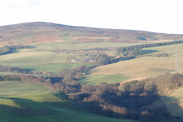
The Blair is a notable hill/mountain located in the Angus region of Scotland. It is situated in the southern part of the Cairngorms National Park, approximately 10 miles north of the town of Blairgowrie. Standing at an elevation of 528 meters (1,732 feet), it offers stunning panoramic views of the surrounding landscape.
The Blair is a popular destination for hikers and outdoor enthusiasts, thanks to its easily accessible location and relatively moderate difficulty level. The hill/mountain is characterized by its grassy slopes and rocky outcrops, which provide an interesting terrain for exploration. The ascent to the summit can be accomplished via various routes, offering different challenges and perspectives along the way.
At the top of The Blair, visitors are rewarded with breathtaking vistas that stretch across the rolling hills of Angus, with glimpses of the Cairngorms to the north. On clear days, it is even possible to see as far as the Grampian Mountains and the North Sea coastline.
The area surrounding The Blair is rich in wildlife, with frequent sightings of deer, mountain hares, and various bird species. It is also home to a diverse range of plant life, including heather, bilberry, and juniper bushes.
Overall, The Blair is a captivating natural landmark that offers a memorable outdoor experience for those seeking to immerse themselves in the beauty of the Scottish countryside.
If you have any feedback on the listing, please let us know in the comments section below.
The Blair Images
Images are sourced within 2km of 56.828074/-2.7032702 or Grid Reference NO5770. Thanks to Geograph Open Source API. All images are credited.


The Blair is located at Grid Ref: NO5770 (Lat: 56.828074, Lng: -2.7032702)
Unitary Authority: Angus
Police Authority: Tayside
What 3 Words
///somewhere.blackmail.notion. Near Brechin, Angus
Nearby Locations
Related Wikis

Edzell Castle
Edzell Castle is a ruined 16th-century castle, with an early-17th-century walled garden. It is located close to Edzell, and is around 5 miles (8 km) north...

Edzell railway station
Edzell railway station served the village of Edzell, Angus, Scotland from 1896 to 1964 on the Brechin and Edzell District Railway. == History == The station...

Edzell
Edzell (; Scots: Aigle; Scottish Gaelic: Eigill) is a village in Angus, Scotland. It is 5 miles (8 km) north of Brechin, by the River North Esk. Edzell...

Inglis Memorial Hall
The Inglis Memorial Hall is a municipal structure in the High Street in Edzell, Angus, Scotland, which for much of the 20th century served as Edzell Parish...

Edzell Woods
Edzell Woods is a village in the Kincardine and Mearns area of Aberdeenshire, Scotland. It is 4 miles (6.4 km) from Edzell by road, but only one mile...

Caterthun
Caterthun, or the Caterthuns, is a ridge of hills near the city of Brechin in Angus, Scotland. The Caterthuns are notable for being the site of two Iron...

RAF Edzell
Royal Air Force Edzell or more simply RAF Edzell is a former Royal Air Force satellite station located in Aberdeenshire, one mile east of Edzell in Angus...
Stracathro railway station
Stracathro railway station served the sparsely populated rural area around the villages of Stracathro and Inchbare as well as Dunlappie and other estates...
Nearby Amenities
Located within 500m of 56.828074,-2.7032702Have you been to The Blair?
Leave your review of The Blair below (or comments, questions and feedback).