Old High

Hill, Mountain in Westmorland South Lakeland

England

Old High

The start of the fun, Borrow Beck Down to about the limit of this view, Borrow Beck rarely rises above grade 2, but here the valley starts to entrench a little and beck becomes steeper and more sporting at grade 3 with perhaps the odd bit of 4. To paddle the full trip from High Borrow Bridge (by the A6 - involving a very long road shuttle compared with the length of the paddle) would need quite a bit more water than this as the channel is wider and shallower, but from here, for 2½ kilometres down to a take-out close to the confluence with the River Lune, you could just about bounce down at this level. With some proper rain rather than today's half-hearted drizzle, it looks like being a worthwhile trip and the first kilometre of the track is public road, making a carry-in with the boat over your shoulder for the kilometre or so to the bridge here not entirely unreasonable. The course from here is somewhat tree-lined, however, so the usual caveats about running blind round bends apply, especially after the sort of stormy winter we've just had.
The start of the fun, Borrow Beck Credit: Andy Waddington

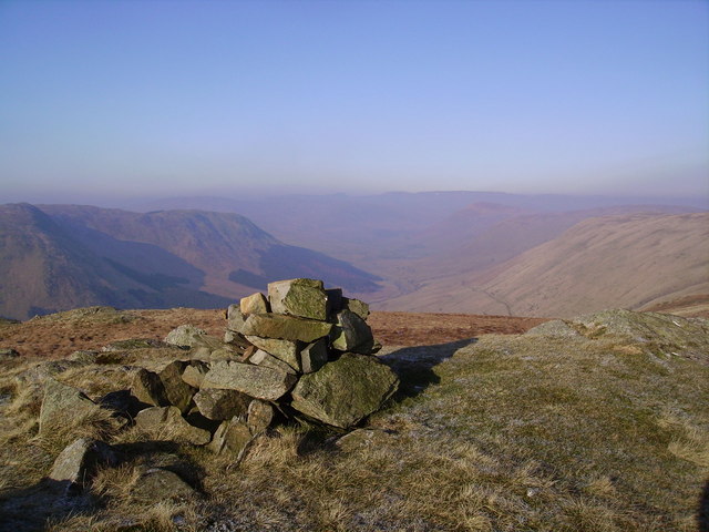
Old High is a prominent hill located in the county of Westmorland, England. With its summit standing at an elevation of approximately 2,415 feet (736 meters), it is considered one of the highest points in the region. Situated in the heart of the Lake District National Park, Old High offers breathtaking views of the surrounding landscape, including nearby mountains and valleys.

The hill is characterized by its rugged terrain, covered in thick grass, heather, and scattered rocks. It is a popular destination for hikers and outdoor enthusiasts, offering a variety of walking trails that cater to different skill levels. The most common starting point for ascending Old High is from the village of Mardale, where visitors can follow well-marked paths leading up the hill.

At the summit, visitors are rewarded with panoramic vistas of the picturesque Lake District. On a clear day, one can spot the nearby peaks of High Street, Harter Fell, and Kidsty Pike, as well as several lakes including Haweswater and Ullswater. The remote and tranquil atmosphere of Old High also makes it a prime location for birdwatching, with various species of birds often spotted in the area.

The hill has a rich history, with evidence of human activity dating back to ancient times. Remnants of Bronze Age settlements have been discovered at the foot of the hill, adding to its cultural significance. Today, Old High continues to captivate visitors with its natural beauty, offering a unique opportunity to explore the rugged charm of the Lake District.

If you have any feedback on the listing, please let us know in the comments section below.

Old High Images

Images are sourced within 2km of 54.405932/-2.667474 or Grid Reference NY5601. Thanks to Geograph Open Source API. All images are credited.

The start of the fun, Borrow Beck Down to about the limit of this view, Borrow Beck rarely rises above grade 2, but here the valley starts to entrench a little and beck becomes steeper and more sporting at grade 3 with perhaps the odd bit of 4. To paddle the full trip from High Borrow Bridge (by the A6 - involving a very long road shuttle compared with the length of the paddle) would need quite a bit more water than this as the channel is wider and shallower, but from here, for 2½ kilometres down to a take-out close to the confluence with the River Lune, you could just about bounce down at this level. With some proper rain rather than today's half-hearted drizzle, it looks like being a worthwhile trip and the first kilometre of the track is public road, making a carry-in with the boat over your shoulder for the kilometre or so to the bridge here not entirely unreasonable. The course from here is somewhat tree-lined, however, so the usual caveats about running blind round bends apply, especially after the sort of stormy winter we've just had.
The start of the fun, Borrow Beck
Down to about the limit of this view, Borrow Beck rarely rises above grade 2, but here the valley starts to entrench a little and beck becomes steeper and more sporting at grade 3 with perhaps the odd bit of 4. To paddle the full trip from High Borrow Bridge (by the A6 - involving a very long road shuttle compared with the length of the paddle) would need quite a bit more water than this as the channel is wider and shallower, but from here, for 2½ kilometres down to a take-out close to the confluence with the River Lune, you could just about bounce down at this level. With some proper rain rather than today's half-hearted drizzle, it looks like being a worthwhile trip and the first kilometre of the track is public road, making a carry-in with the boat over your shoulder for the kilometre or so to the bridge here not entirely unreasonable. The course from here is somewhat tree-lined, however, so the usual caveats about running blind round bends apply, especially after the sort of stormy winter we've just had.
Borrow Beck Apart from the occasional short boulder garden and one cattle fence (just round a blind bend), this stretch is fairly typical of the run down Borrow Beck from the put-in at High Borrow Bridge by the A6 (perhaps easiest at the stepping stones where <a href="https://www.geograph.org.uk/photo/6853810">NY5503 : The Breasthigh road crosses Borrow Beck</a>). Despite the low cloud and persistent drizzle, there's not really enough water to paddle this section today, but a kilometre and a quarter downstream from here the river starts to cut down a little, making the channel narrower, and the paddling more interesting and there's just about enough to bounce down the bottom 2½ kilometres.
Borrow Beck
Apart from the occasional short boulder garden and one cattle fence (just round a blind bend), this stretch is fairly typical of the run down Borrow Beck from the put-in at High Borrow Bridge by the A6 (perhaps easiest at the stepping stones where NY5503 : The Breasthigh road crosses Borrow Beck). Despite the low cloud and persistent drizzle, there's not really enough water to paddle this section today, but a kilometre and a quarter downstream from here the river starts to cut down a little, making the channel narrower, and the paddling more interesting and there's just about enough to bounce down the bottom 2½ kilometres.
Ashstead Beck beside rural road north of Whelpside Ordnance Survey documents indicate that a benchmark levelled at 154.171m above Newlyn Datum was verified in 1954 on a stone at the base of the wall (on the right hand side of the beck) its back face 2.4m from its left hand end
Ashstead Beck beside rural road north of Whelpside
Ordnance Survey documents indicate that a benchmark levelled at 154.171m above Newlyn Datum was verified in 1954 on a stone at the base of the wall (on the right hand side of the beck) its back face 2.4m from its left hand end
Benchmark on stone in wall on NE side of road NW of Harewood Ordnance Survey pivot benchmark levelled at 149.782m above Newlyn Datum verified 1954
Benchmark on stone in wall on NE side of road NW of Harewood
Ordnance Survey pivot benchmark levelled at 149.782m above Newlyn Datum verified 1954
Dry stone wall and gateway on NE side of rural road between Whelpside and Harewood There is an Ordnance Survey benchmark <a href="https://www.geograph.org.uk/photo/7233064">NY5500 : Benchmark on stone in wall on NE side of road NW of Harewood</a> on a light-coloured protruding stone near the base of the wall
Dry stone wall and gateway on NE side of rural road between Whelpside and Harewood
There is an Ordnance Survey benchmark NY5500 : Benchmark on stone in wall on NE side of road NW of Harewood on a light-coloured protruding stone near the base of the wall
Benchmark on barn at Whelpside Ordnance Survey cut mark levelled at 158.126m above Newlyn Datum verified 1954
Benchmark on barn at Whelpside
Ordnance Survey cut mark levelled at 158.126m above Newlyn Datum verified 1954
Farm buildings at Whelpside There is an Ordnance Survey benchmark <a href="https://www.geograph.org.uk/photo/7233223">NY5500 : Benchmark on barn at Whelpside</a> on the left hand side of the large barn at its near corner
Farm buildings at Whelpside
There is an Ordnance Survey benchmark NY5500 : Benchmark on barn at Whelpside on the left hand side of the large barn at its near corner
The summit of Winterscleugh Looking WNW along upper Borrowdale.  (Note: this is the other, lesser-known Borrowdale.)

Winterscleugh was added to the popular Fellranger list of Lake District hills when the border of the Lake District National Park was moved east.
The summit of Winterscleugh
Looking WNW along upper Borrowdale. (Note: this is the other, lesser-known Borrowdale.) Winterscleugh was added to the popular Fellranger list of Lake District hills when the border of the Lake District National Park was moved east.
Puddles and a waterlogged field
Public Bridleway to High Borrowdale
Ovine Obstacle
Ovine Obstacle
Farm track off the A6 The A6 is one of the main historic north south roads in England. At 299 miles long it is the fourth longest road in the country. It currently runs from Luton in Bedfordshire to Carlisle in Cumbria, although it formerly started at a junction with the A1 at Barnet.
Wikipedia: <span class="nowrap"><a title="http://en.wikipedia.org/wiki/A6_road_(England)" rel="nofollow ugc noopener" href="http://en.wikipedia.org/wiki/A6_road_(England)">Link</a><img style="margin-left:2px;" alt="External link" title="External link - shift click to open in new window" src="https://s1.geograph.org.uk/img/external.png" width="10" height="10"/></span> 
See also <span class="nowrap"><a title="http://www.sabre-roads.org.uk/wiki/index.php?title=A6" rel="nofollow ugc noopener" href="http://www.sabre-roads.org.uk/wiki/index.php?title=A6">Link</a><img style="margin-left:2px;" alt="External link" title="External link - shift click to open in new window" src="https://s1.geograph.org.uk/img/external.png" width="10" height="10"/></span> for more route detail.
Farm track off the A6
The A6 is one of the main historic north south roads in England. At 299 miles long it is the fourth longest road in the country. It currently runs from Luton in Bedfordshire to Carlisle in Cumbria, although it formerly started at a junction with the A1 at Barnet. Wikipedia: LinkExternal link See also LinkExternal link for more route detail.
Grazing and pylon, Grisdale View from the A6.
Grazing and pylon, Grisdale
View from the A6.
A6 heading north Towards Shap.
A6 heading north
Towards Shap.
Sharp bend on the A6, heading north
High Borrowdale High Borrowdale in the Borrowdale valley.
High Borrowdale
High Borrowdale in the Borrowdale valley.
Below Borrowdale Edge Looking across freshly mown fields towards a barn in Borrowdale.
Below Borrowdale Edge
Looking across freshly mown fields towards a barn in Borrowdale.
The summit of Whinfell Beacon The summit cairn of Whinfell Beacon.
The summit of Whinfell Beacon
The summit cairn of Whinfell Beacon.
Show me another place!

Old High is located at Grid Ref: NY5601 (Lat: 54.405932, Lng: -2.667474)

Administrative County: Cumbria

District: South Lakeland

Police Authority: Cumbria

What 3 Words

///overhaul.handbags.rungs. Near Burneside, Cumbria

Nearby Locations

Old High Castle Fell

Related Wikis

Whinfell Beacon

Whinfell Beacon is a hill of 472 metres (1,549 ft) in South Lakeland, Cumbria, England, to the east of the Lake District. It is in the far east of the...

Borrowdale, Westmorland

Borrowdale is a valley in the English Lake District. It is located in the county of Westmorland, and is sometimes referred to as Westmorland Borrowdale...

Winterscleugh

Winterscleugh is a hill of 464 metres (1,522 ft) in Cumbria, England, to the east of the Lake District. It is in the far east of the Lake District National...

Whinfell

Whinfell is a civil parish in South Lakeland, Cumbria, England. It does not have a parish council but a parish meeting. The parish lies north east of Kendal...

Nearby Amenities

Located within 500m of 54.405932,-2.667474
Castle Fell
Ele: 470
Natural: peak
Lat/Long: 54.4068775/-2.6638796
Barrier: stile
Lat/Long: 54.4088721/-2.6710249
Old High
Ele: 462
Natural: peak
Lat/Long: 54.4056903/-2.6674294
The data included in this document is from www.openstreetmap.org. The data is made available under ODbL.

Have you been to Old High?

Leave your review of Old High below (or comments, questions and feedback).