Craig of Shanno

Hill, Mountain in Angus

Scotland

Craig of Shanno

Haughend Cadet Centre ..or as it is more commonly known Dalbog Camp. Owned by Highland Reserve Forces
& Cadets Association, the camp is beginning to fall into disrepair. I'm unsure if it is still in use but it definitely needs a bit of money spent to get it up to expected standards
Haughend Cadet Centre Credit: Karen Vernon

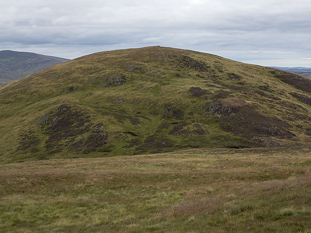
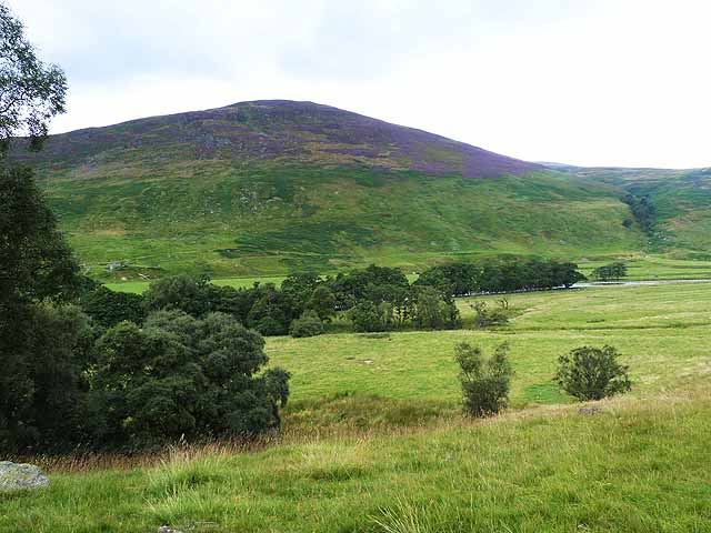
Craig of Shanno, located in Angus, Scotland, is a prominent hill standing at an elevation of approximately 520 meters (1,706 feet) above sea level. It is situated in the eastern part of the country, near the town of Forfar. The hill forms part of the Sidlaw Hills range, which stretches across Angus and Perth and Kinross.

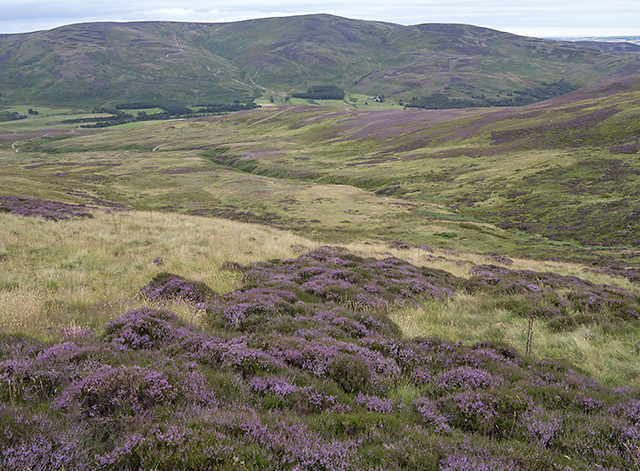
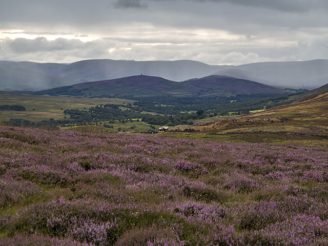
Craig of Shanno offers breathtaking panoramic views of the surrounding landscape, including the fertile farmlands of Strathmore and the picturesque Strathmore Valley. On clear days, the summit provides an excellent vantage point to observe neighboring hills such as Craigowl and Auchterhouse Hill.

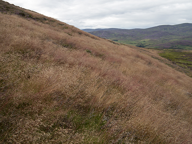
The ascent to the summit can be achieved through various routes, with the most popular being from the car park at Balkello Wood. The path traverses through a mix of open moorland, heather, and woodland, offering hikers an opportunity to immerse themselves in the natural beauty of the Scottish countryside. The hike is of moderate difficulty, making it accessible to a wide range of outdoor enthusiasts.

Craig of Shanno is known for its rich biodiversity, with a variety of flora and fauna found in the area. Visitors may encounter wildlife such as red grouse, hares, and various bird species, including the iconic golden eagle. The hill also boasts an impressive array of plant species, including heather, bilberry, and blaeberry.

Overall, Craig of Shanno provides an excellent outdoor experience for nature lovers, hikers, and photographers alike. Its stunning vistas, diverse wildlife, and accessible trails make it a popular destination for those seeking to explore the natural beauty of Angus.

If you have any feedback on the listing, please let us know in the comments section below.

Craig of Shanno Images

Images are sourced within 2km of 56.873041/-2.7231286 or Grid Reference NO5675. Thanks to Geograph Open Source API. All images are credited.

Haughend Cadet Centre ..or as it is more commonly known Dalbog Camp. Owned by Highland Reserve Forces
& Cadets Association, the camp is beginning to fall into disrepair. I'm unsure if it is still in use but it definitely needs a bit of money spent to get it up to expected standards
Haughend Cadet Centre
..or as it is more commonly known Dalbog Camp. Owned by Highland Reserve Forces & Cadets Association, the camp is beginning to fall into disrepair. I'm unsure if it is still in use but it definitely needs a bit of money spent to get it up to expected standards
Craigoshina in Glen Esk
Across the North Esk valley East Wirren is the hill in the centre distance.
Across the North Esk valley
East Wirren is the hill in the centre distance.
The stalkers' track above Auchmull The older track (which is the one shown on current maps) is seen on the right. Though perhaps less functional, it certainly blended into the landscape better than the new one.
The stalkers' track above Auchmull
The older track (which is the one shown on current maps) is seen on the right. Though perhaps less functional, it certainly blended into the landscape better than the new one.
Moorland by the Burn of Holmhead Boggy ground by the Burn of Holmhead, with heather in bloom in early August.
Moorland by the Burn of Holmhead
Boggy ground by the Burn of Holmhead, with heather in bloom in early August.
Lower slopes of Bulg A faint path through bracken and heather on the lower slopes of Bulg (from Am Bulg, the bag; thus bag hill, a round hill).
Lower slopes of Bulg
A faint path through bracken and heather on the lower slopes of Bulg (from Am Bulg, the bag; thus bag hill, a round hill).
View from Craigangower The southern flank of Bulg viewed on a descent from Craigangower - relatively easy walking here on grass and heather.
View from Craigangower
The southern flank of Bulg viewed on a descent from Craigangower - relatively easy walking here on grass and heather.
North east of Bulg On the lower north eastern slopes of Bulg, heather gives way to a reddish tinged species of grass - this is of delicate structure such that it is swayed by the slightest breeze.
North east of Bulg
On the lower north eastern slopes of Bulg, heather gives way to a reddish tinged species of grass - this is of delicate structure such that it is swayed by the slightest breeze.
Above the Burn of Holmhead A view from the lower slopes of Bulg, over the course of the Burn of Holmhead, a short tributary of the North Esk barely 3km in length.
Above the Burn of Holmhead
A view from the lower slopes of Bulg, over the course of the Burn of Holmhead, a short tributary of the North Esk barely 3km in length.
Moorland north of Bulg The lower slopes of Bulg, viewed as the weather deteriorates on an August evening. Heavy rain can be seen in the distance, beyond the Maul Monument situated on the Hill of Rowan 7km distant.
Moorland north of Bulg
The lower slopes of Bulg, viewed as the weather deteriorates on an August evening. Heavy rain can be seen in the distance, beyond the Maul Monument situated on the Hill of Rowan 7km distant.
The Slack of Forbie The upper region of the Burn of Forbie between Bulg and Craigangower, marked as the Slack of Forbie on OS mapping. This is the source of the Burn of Forbie, one of many tributaries of the North Esk. Farmland north of Montrose and the North Sea can be seen in the distance.
The Slack of Forbie
The upper region of the Burn of Forbie between Bulg and Craigangower, marked as the Slack of Forbie on OS mapping. This is the source of the Burn of Forbie, one of many tributaries of the North Esk. Farmland north of Montrose and the North Sea can be seen in the distance.
River North Esk Below Colmeallie. Looking downstream.
River North Esk
Below Colmeallie. Looking downstream.
River North Esk Below Colmeallie. Looking upstream.
River North Esk
Below Colmeallie. Looking upstream.
Woodland beside the Glenesk road
Helicopter and supporting vehicles in Glenesk Near Waggles Cottage. Uncertain what its purpose was.
Helicopter and supporting vehicles in Glenesk
Near Waggles Cottage. Uncertain what its purpose was.
Looking across Glenesk The mountain opposite is Craig of Shanno <a href="https://www.geograph.org.uk/gridref/NO5675">NO5675</a>.
Looking across Glenesk
The mountain opposite is Craig of Shanno NO5675.
Summit cairn on Bulg The large cairn on the summit of Bulg, with hills to the north of Glen Esk visible on the skyline.
Summit cairn on Bulg
The large cairn on the summit of Bulg, with hills to the north of Glen Esk visible on the skyline.
Uplands to lowlands A view to the east from the Hill of Wirren - Craigangower ridge. This is the eastern edge of the vast Mounth plateau, where high ground gives way to arable lowlands in the Howe of the Mearns. The contrast between upland and lowland areas can clearly be seen in this image, with purple and green dappled hillsides giving way to a patchwork of forest and farmland, which ends abruptly on the shore of the North Sea.
Uplands to lowlands
A view to the east from the Hill of Wirren - Craigangower ridge. This is the eastern edge of the vast Mounth plateau, where high ground gives way to arable lowlands in the Howe of the Mearns. The contrast between upland and lowland areas can clearly be seen in this image, with purple and green dappled hillsides giving way to a patchwork of forest and farmland, which ends abruptly on the shore of the North Sea.
Show me another place!

Craig of Shanno is located at Grid Ref: NO5675 (Lat: 56.873041, Lng: -2.7231286)

Unitary Authority: Angus

Police Authority: Tayside

What 3 Words

///buying.deeper.shopping. Near Laurencekirk, Aberdeenshire

Nearby Locations

Craig of Shanno

Related Wikis

Colmeallie stone circle

The Colmeallie stone circle is a recumbent stone circle in Glen Esk, Angus, Scotland. It is located 8 km north of Edzell at Colmeallie Farm, adjacent to...

Milden, Angus

Milden is a hamlet, estate and farmstead in Glenesk, Angus, Scotland. It is situated in the upper course of the Glen Esk valley, where the Burn of Turret...

Edzell Castle

Edzell Castle is a ruined 16th-century castle, with an early-17th-century walled garden. It is located close to Edzell, and is around 5 miles (8 km) north...

Tarfside

Tarfside is a small hamlet in Angus, Scotland. It is situated in Glen Esk, on the upper course of the River North Esk, around 8 miles north of Edzell,...

Edzell

Edzell (; Scots: Aigle; Scottish Gaelic: Eigill) is a village in Angus, Scotland. It is 5 miles (8 km) north of Brechin, by the River North Esk. Edzell...

Edzell railway station

Edzell railway station served the village of Edzell, Angus, Scotland from 1896 to 1964 on the Brechin and Edzell District Railway. == History == The station...

Inglis Memorial Hall

The Inglis Memorial Hall is a municipal structure in the High Street in Edzell, Angus, Scotland, which for much of the 20th century served as Edzell Parish...

Mount Battock

Mount Battock (778 m) is a mountain in the Mounth on the eastern edge of the Scottish Highlands, on the border between Aberdeenshire and Angus. A rounded...

Nearby Amenities

Located within 500m of 56.873041,-2.7231286
Craig of Shanno
Ele: 407
Natural: peak
Lat/Long: 56.8723415/-2.7222834
The data included in this document is from www.openstreetmap.org. The data is made available under ODbL.

Have you been to Craig of Shanno?

Leave your review of Craig of Shanno below (or comments, questions and feedback).