Hill of Corathro

Hill, Mountain in Angus

Scotland

Hill of Corathro

Black Hill, West of Edzell Black Hill (393m) on the right horizon, the Burn of Oldtown runs from left to right (North to South) in the valley. The area is managed grouse moorland with signs of regular burning of the heather to encourage new growth for the grouse to feed on
Black Hill, West of Edzell Credit: David G Campbell

Hill of Corathro is a prominent hill located in the county of Angus, Scotland. Situated about 4 miles southeast of the town of Edzell, it stands at an elevation of 430 meters (1,411 feet) above sea level. The hill is part of the Grampian Mountains range and offers stunning panoramic views of the surrounding countryside.

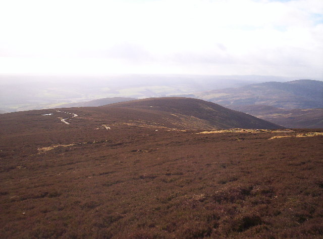
Hill of Corathro is known for its distinctive cone-shaped summit, which is covered with heather and grasses. The hill is primarily composed of granite, giving it a rugged appearance. Its slopes are relatively steep, providing a challenging ascent for hikers and climbers.

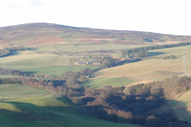
The hill is largely uninhabited and remains untouched by human development, making it an ideal destination for those seeking solitude and a connection with nature. It is home to a variety of flora and fauna, including heather, bilberry, and various species of birds and small mammals.

Hill of Corathro is a popular outdoor recreational area, attracting hillwalkers, hikers, and nature enthusiasts. It features a network of footpaths and trails that allow visitors to explore its diverse landscape. The hill can be accessed from multiple directions, with the most common starting point being the nearby village of Edzell.

Overall, Hill of Corathro offers a picturesque and tranquil setting for outdoor activities, providing visitors with an opportunity to appreciate the natural beauty of the Angus countryside.

If you have any feedback on the listing, please let us know in the comments section below.

Hill of Corathro Images

Images are sourced within 2km of 56.839495/-2.7263334 or Grid Reference NO5572. Thanks to Geograph Open Source API. All images are credited.

Black Hill, West of Edzell Black Hill (393m) on the right horizon, the Burn of Oldtown runs from left to right (North to South) in the valley. The area is managed grouse moorland with signs of regular burning of the heather to encourage new growth for the grouse to feed on
Black Hill, West of Edzell
Black Hill (393m) on the right horizon, the Burn of Oldtown runs from left to right (North to South) in the valley. The area is managed grouse moorland with signs of regular burning of the heather to encourage new growth for the grouse to feed on
Wooden gate on East Wirren Wooden gate barring the route down the eastern flank of East Wirren.
Wooden gate on East Wirren
Wooden gate barring the route down the eastern flank of East Wirren.
View north from the Hill of Corathro Looking to the Shank of Arlone from the top of the Hill of Corathro.
View north from the Hill of Corathro
Looking to the Shank of Arlone from the top of the Hill of Corathro.
Track down the Hill of Corathro Track heading down the north-east flank of the Hill of Corathro, with The Crannel ahead.
Track down the Hill of Corathro
Track heading down the north-east flank of the Hill of Corathro, with The Crannel ahead.
Track crossroads Intersection of Bulldozed tracks, viewed from the slopes of The Crannel.
Track crossroads
Intersection of Bulldozed tracks, viewed from the slopes of The Crannel.
The Crannel trig pillar The triangulation pillar on The Crannel, looking towards East Wirren.
The Crannel trig pillar
The triangulation pillar on The Crannel, looking towards East Wirren.
Meikle Tullo Farm Craigangowan, Craigancash and Sturdy Hill on the left of the photo.
Meikle Tullo Farm
Craigangowan, Craigancash and Sturdy Hill on the left of the photo.
Rough Grazing Near Cowiehill The slope on the left is the tail end of The Blair and a small reservoir.
Rough Grazing Near Cowiehill
The slope on the left is the tail end of The Blair and a small reservoir.
Track From Cowiehill to East Wirren Strathfinnella Hill in the centre distance
Track From Cowiehill to East Wirren
Strathfinnella Hill in the centre distance
Coire between Black Hill and Hill of Corathro
East Wirren From Hill of Corathro
Source of Burn of Oldtown
Torr Na Menach From the track junction just below East Wirren
Torr Na Menach
From the track junction just below East Wirren
Heathery Mountainside on East Wirren
Margie Farm, Glenlethnot, Edzell, looking across the Westwater from Lundie
Looking up track to summit of East Wirren
East Wirren Looking up at East Wirren from the East.
East Wirren
Looking up at East Wirren from the East.
Stalkers Hut This hut is used by shooting parties when a spot of lunch is required, it sits in a lovely spot beside the Burn of Mooran
Stalkers Hut
This hut is used by shooting parties when a spot of lunch is required, it sits in a lovely spot beside the Burn of Mooran
Show me another place!

Hill of Corathro is located at Grid Ref: NO5572 (Lat: 56.839495, Lng: -2.7263334)

Unitary Authority: Angus

Police Authority: Tayside

What 3 Words

///third.possible.factoring. Near Brechin, Angus

Nearby Locations

Hill of Corathro

Related Wikis

Edzell Castle

Edzell Castle is a ruined 16th-century castle, with an early-17th-century walled garden. It is located close to Edzell, and is around 5 miles (8 km) north...

Edzell railway station

Edzell railway station served the village of Edzell, Angus, Scotland from 1896 to 1964 on the Brechin and Edzell District Railway. == History == The station...

Edzell

Edzell (; Scots: Aigle; Scottish Gaelic: Eigill) is a village in Angus, Scotland. It is 5 miles (8 km) north of Brechin, by the River North Esk. Edzell...

Inglis Memorial Hall

The Inglis Memorial Hall is a municipal structure in the High Street in Edzell, Angus, Scotland, which for much of the 20th century served as Edzell Parish...

Nearby Amenities

Located within 500m of 56.839495,-2.7263334
Hill of Corathro
Alt Name: Hill of Corethrie
Ele: 402
Name Gd: Cor Uachdarach
Natural: peak
Lat/Long: 56.8390697/-2.7258883
Ardbeast
Name Gd: Àird Bèiste
Note: Grouse moor
Place: locality
Lat/Long: 56.8405704/-2.7189591
The data included in this document is from www.openstreetmap.org. The data is made available under ODbL.

Have you been to Hill of Corathro?

Leave your review of Hill of Corathro below (or comments, questions and feedback).