Craig of Dalhastnie

Hill, Mountain in Angus

Scotland

Craig of Dalhastnie

Mill of Aucheen Looking up the road to the farmhouse at the Mill of Aucheen.
Mill of Aucheen Credit: Scott Cormie

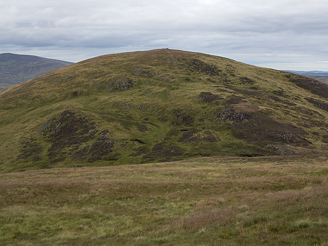
Craig of Dalhastnie is a prominent hill located in the county of Angus, Scotland. Standing at an elevation of 437 meters (1434 feet), it is a popular destination for hikers and nature enthusiasts.

The hill is situated about 5 kilometers southwest of the town of Kirriemuir and is part of the Angus Glens, which are renowned for their stunning natural beauty. Craig of Dalhastnie is characterized by its gently sloping grassy slopes, offering a relatively easy ascent for visitors of all fitness levels.

From the summit of Craig of Dalhastnie, visitors are rewarded with breathtaking panoramic views of the surrounding Angus countryside. On clear days, it is even possible to catch glimpses of the distant North Sea coastline. The hill is particularly picturesque during the spring and summer months when wildflowers dot the landscape, adding vibrant splashes of color.

Access to Craig of Dalhastnie is straightforward, with a well-marked trail leading from a nearby car park. The hike to the summit typically takes around an hour, depending on the pace and fitness level of the individual. Along the way, walkers can enjoy the diverse flora and fauna that inhabit the hill, including various bird species and small mammals.

Overall, Craig of Dalhastnie offers a delightful outdoor experience, combining stunning vistas, accessibility, and an opportunity to immerse oneself in the natural beauty of the Angus countryside.

If you have any feedback on the listing, please let us know in the comments section below.

Craig of Dalhastnie Images

Images are sourced within 2km of 56.889638/-2.7512036 or Grid Reference NO5477. Thanks to Geograph Open Source API. All images are credited.

Mill of Aucheen Looking up the road to the farmhouse at the Mill of Aucheen.
Mill of Aucheen
Looking up the road to the farmhouse at the Mill of Aucheen.
Meadowside by the North Esk Grassy meadow on the north side of the river in Glen Esk near Millden.
Meadowside by the North Esk
Grassy meadow on the north side of the river in Glen Esk near Millden.
Car park at Millden Car parking area next to the telephone kiosk at Millden, the starting point for ascents of Mount Battock from Glen Esk.
Car park at Millden
Car parking area next to the telephone kiosk at Millden, the starting point for ascents of Mount Battock from Glen Esk.
Old Mill at Millden One of the old converted buildings in the area
Old Mill at Millden
One of the old converted buildings in the area
Small bridge for the brave This bridge is over a small burn but doesn't look very safe to me.
Small bridge for the brave
This bridge is over a small burn but doesn't look very safe to me.
Road from Glen Esk Looking down the road from Glen Esk
Road from Glen Esk
Looking down the road from Glen Esk
Looking up Glen Esk The view from a handy layby
Looking up Glen Esk
The view from a handy layby
Dalhastnie footbridge Private footbridge over the River North Esk to Millden Lodge. Locked gates on the bridge prevent trespassers
Dalhastnie footbridge
Private footbridge over the River North Esk to Millden Lodge. Locked gates on the bridge prevent trespassers
Millden Lodge Very pretty shooting lodge - as far as I know the lodge is only used occasionally
Millden Lodge
Very pretty shooting lodge - as far as I know the lodge is only used occasionally
Glenesk grassland Looking down the glen
Glenesk grassland
Looking down the glen
Rocks on the North Esk Interesting rock formations as the river cuts its way through the landscape. Taken from a private vehicle bridge crossing the river.
Rocks on the North Esk
Interesting rock formations as the river cuts its way through the landscape. Taken from a private vehicle bridge crossing the river.
Fernybank Cottage Looking across from the other side of the river. The awesome slide in the garden definitely makes the most of its surroundings.
Fernybank Cottage
Looking across from the other side of the river. The awesome slide in the garden definitely makes the most of its surroundings.
Phonebox near Millden in Glen Esk
View of the River North Esk near Millden
Moorland by the Burn of Holmhead Boggy ground by the Burn of Holmhead, with heather in bloom in early August.
Moorland by the Burn of Holmhead
Boggy ground by the Burn of Holmhead, with heather in bloom in early August.
Lower slopes of Bulg A faint path through bracken and heather on the lower slopes of Bulg (from Am Bulg, the bag; thus bag hill, a round hill).
Lower slopes of Bulg
A faint path through bracken and heather on the lower slopes of Bulg (from Am Bulg, the bag; thus bag hill, a round hill).
Hillside south of Glen Esk Ragwort growing on the hillside above the river North Esk, with the 607 metre summit of Bulg visible in the distance.
Hillside south of Glen Esk
Ragwort growing on the hillside above the river North Esk, with the 607 metre summit of Bulg visible in the distance.
View from Craigangower The southern flank of Bulg viewed on a descent from Craigangower - relatively easy walking here on grass and heather.
View from Craigangower
The southern flank of Bulg viewed on a descent from Craigangower - relatively easy walking here on grass and heather.
Show me another place!

Craig of Dalhastnie is located at Grid Ref: NO5477 (Lat: 56.889638, Lng: -2.7512036)

Unitary Authority: Angus

Police Authority: Tayside

What 3 Words

///dictation.stuns.clincher. Near Laurencekirk, Aberdeenshire

Nearby Locations

Craig of Dalhastnie

Related Wikis

Milden, Angus

Milden is a hamlet, estate and farmstead in Glenesk, Angus, Scotland. It is situated in the upper course of the Glen Esk valley, where the Burn of Turret...

Colmeallie stone circle

The Colmeallie stone circle is a recumbent stone circle in Glen Esk, Angus, Scotland. It is located 8 km north of Edzell at Colmeallie Farm, adjacent to...

Tarfside

Tarfside is a small hamlet in Angus, Scotland. It is situated in Glen Esk, on the upper course of the River North Esk, around 8 miles north of Edzell,...

Mount Battock

Mount Battock (778 m) is a mountain in the Mounth on the eastern edge of the Scottish Highlands, on the border between Aberdeenshire and Angus. A rounded...

Edzell Castle

Edzell Castle is a ruined 16th-century castle, with an early-17th-century walled garden. It is located close to Edzell, and is around 5 miles (8 km) north...

Nearby Amenities

Located within 500m of 56.889638,-2.7512036
Craig of Dalhastnie
Place: locality
Lat/Long: 56.8898799/-2.7541378
The data included in this document is from www.openstreetmap.org. The data is made available under ODbL.

Have you been to Craig of Dalhastnie?

Leave your review of Craig of Dalhastnie below (or comments, questions and feedback).