Craig Narb

Hill, Mountain in Angus

Scotland

Craig Narb

Walled fields From the Glen Lethnot road looking across West Water valley to the walled fields
Walled fields Credit: Shaun Ferguson

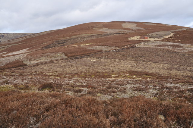
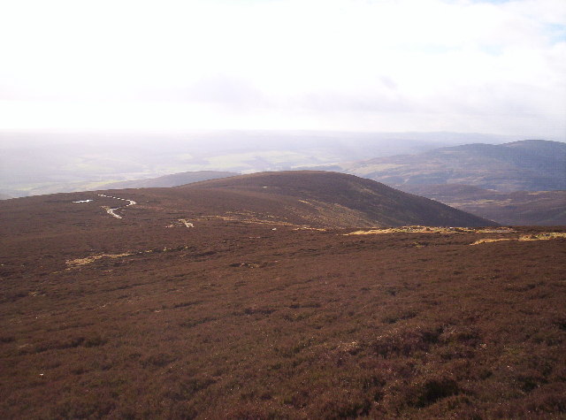
Craig Narb is a prominent hill located in the Angus region of Scotland. It is part of the Grampian Mountains, which stretch across the eastern part of the country. Standing at an elevation of approximately 594 meters (1,949 feet), Craig Narb is renowned for its breathtaking views and picturesque landscapes.

The hill is characterized by its distinct rocky terrain, with steep slopes and craggy outcrops. This rugged landscape attracts hikers, climbers, and nature enthusiasts from all over the world. The ascent to the summit is challenging, but the reward is well worth the effort, as it offers panoramic vistas of the surrounding countryside, including the nearby Loch Brandy and Loch Wharral.

Craig Narb is also notable for its rich biodiversity. The hill is home to various plant species, including heather, mosses, and lichens, which thrive in the moist and cool climate. Wildlife is abundant, with sightings of red deer, mountain hares, and golden eagles being common.

The hill has historical significance as well. It is believed to have been used as a site for ancient rituals and gatherings. The remains of stone circles and cairns can still be found on the slopes of Craig Narb, providing a glimpse into the area's ancient past.

Overall, Craig Narb is a captivating natural landmark that offers visitors a chance to immerse themselves in Scotland's stunning scenery and embrace its rich cultural heritage.

If you have any feedback on the listing, please let us know in the comments section below.

Craig Narb Images

Images are sourced within 2km of 56.828858/-2.7639145 or Grid Reference NO5371. Thanks to Geograph Open Source API. All images are credited.

Walled fields From the Glen Lethnot road looking across West Water valley to the walled fields
Walled fields
From the Glen Lethnot road looking across West Water valley to the walled fields
Burn of Oldtown, West of Edzell The valley of the Burn of Oldtown runs across from left to right (North to South). With the exception of some rough pasture on the right the whole area is managed grouse moorland, with clear signs of regular heather burning and lines of grouse shooting butts.
Burn of Oldtown, West of Edzell
The valley of the Burn of Oldtown runs across from left to right (North to South). With the exception of some rough pasture on the right the whole area is managed grouse moorland, with clear signs of regular heather burning and lines of grouse shooting butts.
Hill of Formal, West of Edzell Managed grouse moorland, with clear signs of irregular patches of heather burning. The area has frequent lines of grouse shooting butts.
Hill of Formal, West of Edzell
Managed grouse moorland, with clear signs of irregular patches of heather burning. The area has frequent lines of grouse shooting butts.
Black Hill, West of Edzell Black Hill (393m) on the right horizon, the Burn of Oldtown runs from left to right (North to South) in the valley. The area is managed grouse moorland with signs of regular burning of the heather to encourage new growth for the grouse to feed on
Black Hill, West of Edzell
Black Hill (393m) on the right horizon, the Burn of Oldtown runs from left to right (North to South) in the valley. The area is managed grouse moorland with signs of regular burning of the heather to encourage new growth for the grouse to feed on
Torr na Menach, Northwest of Edzell Grouse moorland showing multiple stages of the effects of regular heather burning. Including recently burnt (dark at left centre) to fully grown (foreground and large areas on the hill), or at least as fully grown as it's ever going to attain given the burning, the altitude and the climate.
Torr na Menach, Northwest of Edzell
Grouse moorland showing multiple stages of the effects of regular heather burning. Including recently burnt (dark at left centre) to fully grown (foreground and large areas on the hill), or at least as fully grown as it's ever going to attain given the burning, the altitude and the climate.
Burn of Drumcairn, West of Edzell An area of managed grouse moorland, showing signs of regular heather burning. On the right of the image the burn can be seen to have produced a series of small interlocking spurs as it has eroded the valley.
Burn of Drumcairn, West of Edzell
An area of managed grouse moorland, showing signs of regular heather burning. On the right of the image the burn can be seen to have produced a series of small interlocking spurs as it has eroded the valley.
Finnoch The fields, and broken dykes remain of Finnoch, a ruined farm in Glen Lethnot.
Finnoch
The fields, and broken dykes remain of Finnoch, a ruined farm in Glen Lethnot.
Across the West Water valley The Hill of Wirren is on the distant horizon.
Across the West Water valley
The Hill of Wirren is on the distant horizon.
Looking across Glen Lethnot The West Water flows  amongst the trees in the floor of the Glen.
Looking across Glen Lethnot
The West Water flows amongst the trees in the floor of the Glen.
Wire suspension footbridge over West Water Not for the faint hearted!
Wire suspension footbridge over West Water
Not for the faint hearted!
Oldtown from a distance The hillside farmstead of Oldtown, seen from the track to the west, with the Hill of Edzell beyond and the Hill of Garvock on the horizon.
Oldtown from a distance
The hillside farmstead of Oldtown, seen from the track to the west, with the Hill of Edzell beyond and the Hill of Garvock on the horizon.
Tin bothy Bothy on the slopes of the Hill of Formal.
Tin bothy
Bothy on the slopes of the Hill of Formal.
Cairn on Craig Narb Distant view of the cairn (with gulls atop) on Craig Narb, with the Sidlaw Hills on the horizon.
Cairn on Craig Narb
Distant view of the cairn (with gulls atop) on Craig Narb, with the Sidlaw Hills on the horizon.
Ford of the Burn of Drumcairn Track fording the Burn of Drumcairn, viewed from the south.
Ford of the Burn of Drumcairn
Track fording the Burn of Drumcairn, viewed from the south.
Track, Shank of Ledmanie Track heading up to the Hill of Wirren along the Shank of Ledmanie.
Track, Shank of Ledmanie
Track heading up to the Hill of Wirren along the Shank of Ledmanie.
Torr na Menach from the north Looking down on the heathery lump of Torr na Menach from the track to the north.
Torr na Menach from the north
Looking down on the heathery lump of Torr na Menach from the track to the north.
Source of Burn of Oldtown
Torr Na Menach From the track junction just below East Wirren
Torr Na Menach
From the track junction just below East Wirren
Show me another place!

Craig Narb is located at Grid Ref: NO5371 (Lat: 56.828858, Lng: -2.7639145)

Unitary Authority: Angus

Police Authority: Tayside

What 3 Words

///breathy.uncouth.emperor. Near Brechin, Angus

Nearby Locations

Craig Narb

Related Wikis

Caterthun

Caterthun, or the Caterthuns, is a ridge of hills near the city of Brechin in Angus, Scotland. The Caterthuns are notable for being the site of two Iron...

Edzell Castle

Edzell Castle is a ruined 16th-century castle, with an early-17th-century walled garden. It is located close to Edzell, and is around 5 miles (8 km) north...

Menmuir

Menmuir is a parish in the county of Angus in Scotland. Kirkton of Menmuir consists of only three houses (the Old Schoolhouse, the Manse, the Old Inn)...

Edzell railway station

Edzell railway station served the village of Edzell, Angus, Scotland from 1896 to 1964 on the Brechin and Edzell District Railway. == History == The station...

Edzell

Edzell (; Scots: Aigle; Scottish Gaelic: Eigill) is a village in Angus, Scotland. It is 5 miles (8 km) north of Brechin, by the River North Esk. Edzell...

Inglis Memorial Hall

The Inglis Memorial Hall is a municipal structure in the High Street in Edzell, Angus, Scotland, which for much of the 20th century served as Edzell Parish...

Colmeallie stone circle

The Colmeallie stone circle is a recumbent stone circle in Glen Esk, Angus, Scotland. It is located 8 km north of Edzell at Colmeallie Farm, adjacent to...

Milden, Angus

Milden is a hamlet, estate and farmstead in Glenesk, Angus, Scotland. It is situated in the upper course of the Glen Esk valley, where the Burn of Turret...

Nearby Amenities

Located within 500m of 56.828858,-2.7639145
Craig Narb
Place: locality
Lat/Long: 56.8288788/-2.7617702
The data included in this document is from www.openstreetmap.org. The data is made available under ODbL.

Have you been to Craig Narb?

Leave your review of Craig Narb below (or comments, questions and feedback).