Glastonbury Tor

Hill, Mountain in Somerset Mendip

England

Glastonbury Tor

Glastonbury Abbey <span class="nowrap"><a title="https://historicengland.org.uk/listing/the-list/list-entry/1021077?section=official-listing" rel="nofollow ugc noopener" href="https://historicengland.org.uk/listing/the-list/list-entry/1021077?section=official-listing">Link</a><img style="margin-left:2px;" alt="External link" title="External link - shift click to open in new window" src="https://s1.geograph.org.uk/img/external.png" width="10" height="10"/></span>
Glastonbury Abbey Credit: Sandy Gerrard

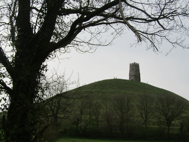
Glastonbury Tor is a prominent hill located in Somerset, England. Rising 518 feet above sea level, it stands as a distinctive landmark in the otherwise flat surrounding landscape. The Tor is situated on the outskirts of the town of Glastonbury and is visible from miles away, making it a popular tourist attraction and pilgrimage site for its historical, geological, and mythical significance.

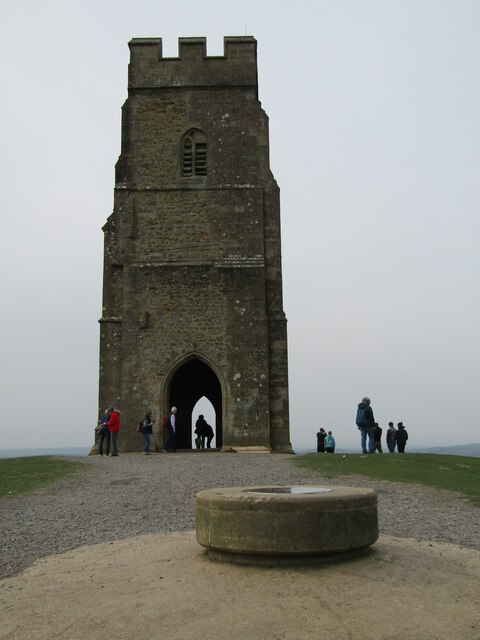
The hill is formed of limestone and is topped by the ruins of St. Michael's Tower, a medieval church tower dating back to the 14th century. The tower is all that remains of the former Church of St. Michael, which was destroyed during the Dissolution of the Monasteries in the 16th century. The tower itself holds a compelling history, having been used as a navigational landmark for pilgrims and sailors, and serving as a signal tower during World War II.

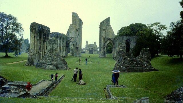
Glastonbury Tor is steeped in legend, often associated with the mythical realm of Avalon and the Arthurian tales. According to local folklore, it is believed to be the entrance to the mysterious underground kingdom of the fairies. The hill is also strongly linked to Christian mythology, with some claiming it to be the site of Joseph of Arimathea's arrival in Britain and the burial place of King Arthur and Queen Guinevere.

Aside from its cultural and historical significance, Glastonbury Tor offers breathtaking panoramic views of the surrounding countryside. Visitors can embark on a rewarding hike up the steep slopes to reach the summit, where they can take in the stunning vistas of the Somerset Levels, the Mendip Hills, and the distant Welsh mountains.

Overall, Glastonbury Tor stands as an iconic landmark, brimming with history, mythology, and natural beauty, making it a must-visit destination for locals and tourists alike.

If you have any feedback on the listing, please let us know in the comments section below.

Glastonbury Tor Images

Images are sourced within 2km of 51.144882/-2.6982806 or Grid Reference ST5138. Thanks to Geograph Open Source API. All images are credited.

Glastonbury Abbey <span class="nowrap"><a title="https://historicengland.org.uk/listing/the-list/list-entry/1021077?section=official-listing" rel="nofollow ugc noopener" href="https://historicengland.org.uk/listing/the-list/list-entry/1021077?section=official-listing">Link</a><img style="margin-left:2px;" alt="External link" title="External link - shift click to open in new window" src="https://s1.geograph.org.uk/img/external.png" width="10" height="10"/></span>
Glastonbury Abbey
Glastonbury - Market Cross The Victorian Gothic (1846) cross replaces its medieval octagonal predecessor and was designed on Waltham Cross in London by Sir Benjamin Ferry.
In the background is The Crown.
Glastonbury - Market Cross
The Victorian Gothic (1846) cross replaces its medieval octagonal predecessor and was designed on Waltham Cross in London by Sir Benjamin Ferry. In the background is The Crown.
Glastonbury - Market Place A busy and colourful corner of Glastonbury.
The "Mendip Explorer" bus is operated by First Mendip and connects Bristol with Street.
Glastonbury - Market Place
A busy and colourful corner of Glastonbury. The "Mendip Explorer" bus is operated by First Mendip and connects Bristol with Street.
Glastonbury - High Street Shopping Shop windows - flower power is still alive and well in Glastonbury.
Glastonbury - High Street Shopping
Shop windows - flower power is still alive and well in Glastonbury.
Glastonbury - The George & Pilgrim's Inn Reputedly Europe's best preserved medieval inn, it was rebuilt ca 1455-75 to house abbey visitors. The old inn on the High Street is now a hotel.
Glastonbury - The George & Pilgrim's Inn
Reputedly Europe's best preserved medieval inn, it was rebuilt ca 1455-75 to house abbey visitors. The old inn on the High Street is now a hotel.
Glastonbury - Mural "Glastonbury Experience" by Jon Minshull - one of several artworks on the Glastonbury Mural Trail.
<span class="nowrap"><a title="www.glastonbury.gov.uk" rel="nofollow ugc noopener" href="http://www.glastonbury.gov.uk">Link</a><img style="margin-left:2px;" alt="External link" title="External link - shift click to open in new window" src="https://s1.geograph.org.uk/img/external.png" width="10" height="10"/></span>
Glastonbury - Mural
"Glastonbury Experience" by Jon Minshull - one of several artworks on the Glastonbury Mural Trail. LinkExternal link
Glastonbury - High Street Glastonbury Tribunal is a historic building dating back to the late 15th century.
<span class="nowrap"><a title="www.glastonbury.gov.uk" rel="nofollow ugc noopener" href="http://www.glastonbury.gov.uk">Link</a><img style="margin-left:2px;" alt="External link" title="External link - shift click to open in new window" src="https://s1.geograph.org.uk/img/external.png" width="10" height="10"/></span>
Glastonbury - High Street
Glastonbury Tribunal is a historic building dating back to the late 15th century. LinkExternal link
Glastonbury - The Goddess and The Green Man A colourful facade and alternative shopping on the High Street.
<span class="nowrap"><a title="www.glastonbury.gov.uk" rel="nofollow ugc noopener" href="http://www.glastonbury.gov.uk">Link</a><img style="margin-left:2px;" alt="External link" title="External link - shift click to open in new window" src="https://s1.geograph.org.uk/img/external.png" width="10" height="10"/></span>
Glastonbury - The Goddess and The Green Man
A colourful facade and alternative shopping on the High Street. LinkExternal link
Glastonbury - The Goddess Rainbow's End Cafe meets The Goddess - esoteric shops on Glastonbury's High Street.
<span class="nowrap"><a title="www.glastonbury.gov.uk" rel="nofollow ugc noopener" href="http://www.glastonbury.gov.uk">Link</a><img style="margin-left:2px;" alt="External link" title="External link - shift click to open in new window" src="https://s1.geograph.org.uk/img/external.png" width="10" height="10"/></span>
Glastonbury - The Goddess
Rainbow's End Cafe meets The Goddess - esoteric shops on Glastonbury's High Street. LinkExternal link
Glastonbury - St John's Church The Norman parish church was rebuilt in Perpendicular Gothic style in the 15th century. The tower dates back to 1475.
Glastonbury - St John's Church
The Norman parish church was rebuilt in Perpendicular Gothic style in the 15th century. The tower dates back to 1475.
Glastonbury - St John's Church Interior Font, east window, altar and pulpit inside this 15th century building.
Glastonbury - St John's Church Interior
Font, east window, altar and pulpit inside this 15th century building.
Glastonbury - Abbey Retreat House Historic building on Chilkwell Street, former home to an Australian pioneer, Austin Family.
<span class="nowrap"><a title="www.glastonbury.gov.uk" rel="nofollow ugc noopener" href="http://www.glastonbury.gov.uk">Link</a><img style="margin-left:2px;" alt="External link" title="External link - shift click to open in new window" src="https://s1.geograph.org.uk/img/external.png" width="10" height="10"/></span>
Glastonbury - Abbey Retreat House
Historic building on Chilkwell Street, former home to an Australian pioneer, Austin Family. LinkExternal link
Glastonbury - Bushy Coombe A nature reserve in a valley on the north side of Chalice Hill.
<span class="nowrap"><a title="www.glastonbury.gov.uk" rel="nofollow ugc noopener" href="http://www.glastonbury.gov.uk">Link</a><img style="margin-left:2px;" alt="External link" title="External link - shift click to open in new window" src="https://s1.geograph.org.uk/img/external.png" width="10" height="10"/></span>
Glastonbury - Bushy Coombe
A nature reserve in a valley on the north side of Chalice Hill. LinkExternal link
Kill Putin An angry message painted on Well House Lane, Glastonbury while Russia has invaded Ukraine, 2022.
Kill Putin
An angry message painted on Well House Lane, Glastonbury while Russia has invaded Ukraine, 2022.
Glastonbury Tor Fabled and landmark hill (520 feet / 158 metres amsl) east of Glastonbury town centre. The tower is all that remains of St Michael's Church.
<span class="nowrap"><a title="www.glastonbury.gov.uk" rel="nofollow ugc noopener" href="http://www.glastonbury.gov.uk">Link</a><img style="margin-left:2px;" alt="External link" title="External link - shift click to open in new window" src="https://s1.geograph.org.uk/img/external.png" width="10" height="10"/></span>
Glastonbury Tor
Fabled and landmark hill (520 feet / 158 metres amsl) east of Glastonbury town centre. The tower is all that remains of St Michael's Church. LinkExternal link
Glastonbury Tor National Trust sign by a footpath leading to the hilltop from the north.
Glastonbury Tor
National Trust sign by a footpath leading to the hilltop from the north.
Glastonbury Tor - Standing Stone Ornate incised stone with carvings and a bell, sited by Well House Lane.
Glastonbury Tor - Standing Stone
Ornate incised stone with carvings and a bell, sited by Well House Lane.
Glastonbury Tor - Tower The tower on top of The Tor is all that remains of St Michael's Church. It is a local landmark from miles around the hill.
<span class="nowrap"><a title="www.glastonbury.gov.uk" rel="nofollow ugc noopener" href="http://www.glastonbury.gov.uk">Link</a><img style="margin-left:2px;" alt="External link" title="External link - shift click to open in new window" src="https://s1.geograph.org.uk/img/external.png" width="10" height="10"/></span>
Glastonbury Tor - Tower
The tower on top of The Tor is all that remains of St Michael's Church. It is a local landmark from miles around the hill. LinkExternal link
Show me another place!

Glastonbury Tor is located at Grid Ref: ST5138 (Lat: 51.144882, Lng: -2.6982806)

Administrative County: Somerset

District: Mendip

Police Authority: Avon and Somerset

What 3 Words

///tangible.couch.tradition. Near Glastonbury, Somerset

Related Wikis

Glastonbury Tor

Glastonbury Tor is a tor near Glastonbury in the English county of Somerset, topped by the roofless St Michael's Tower, a Grade I listed building. The...
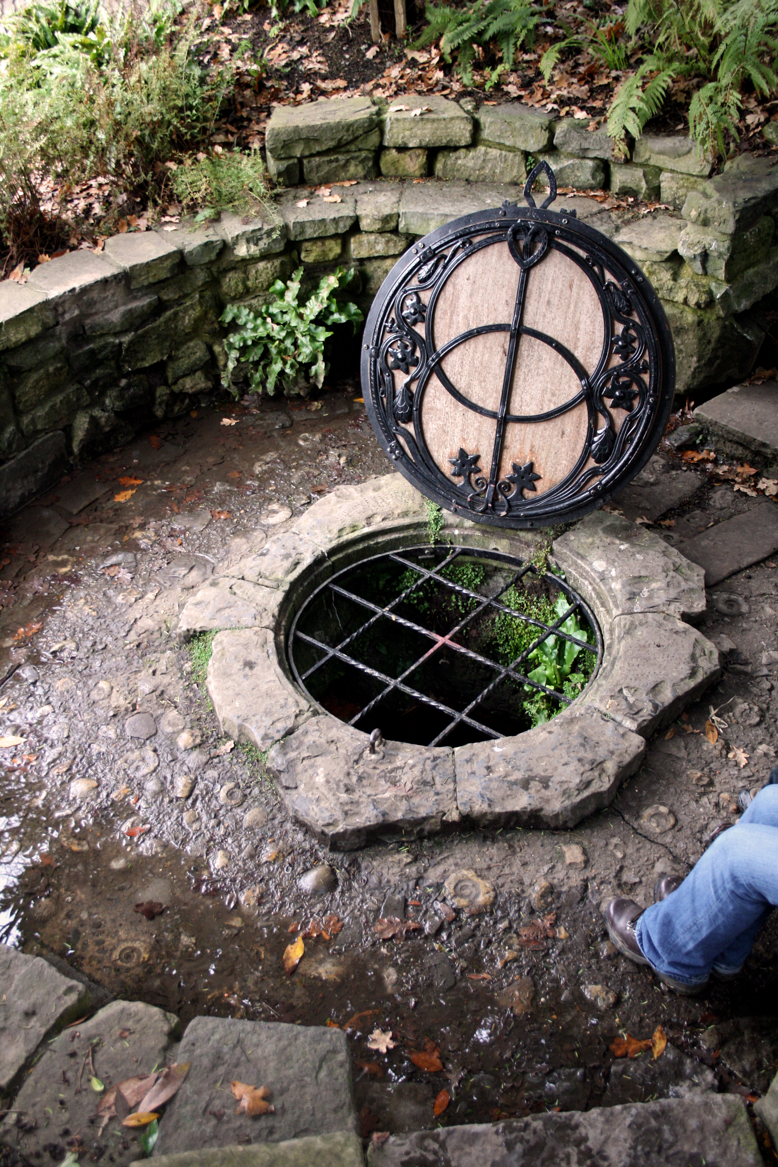
Chalice Well

The Chalice Well, also known as the Red Spring, is a well situated near the summit of Chalice Hill, a small hill next to Glastonbury Tor in Glastonbury...

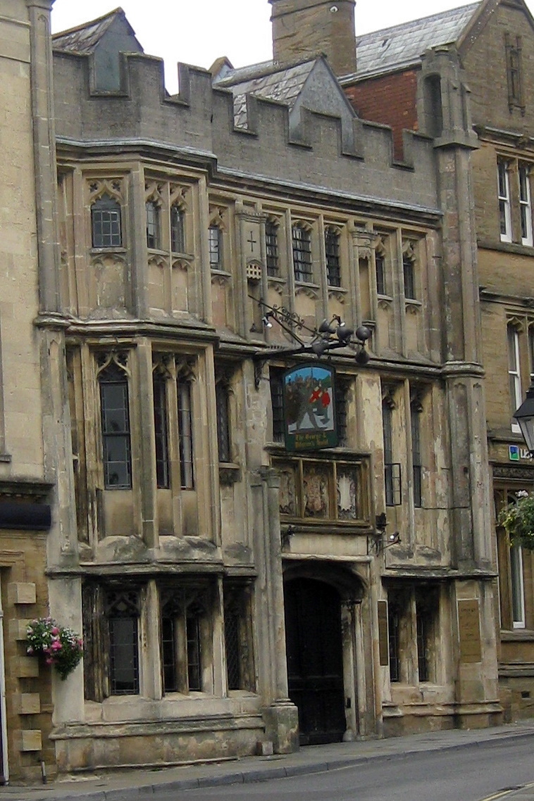
George Hotel and Pilgrims' Inn, Glastonbury

The George Hotel and Pilgrims' Inn in Glastonbury, Somerset, England, was built in the late 15th century to accommodate visitors to Glastonbury Abbey....

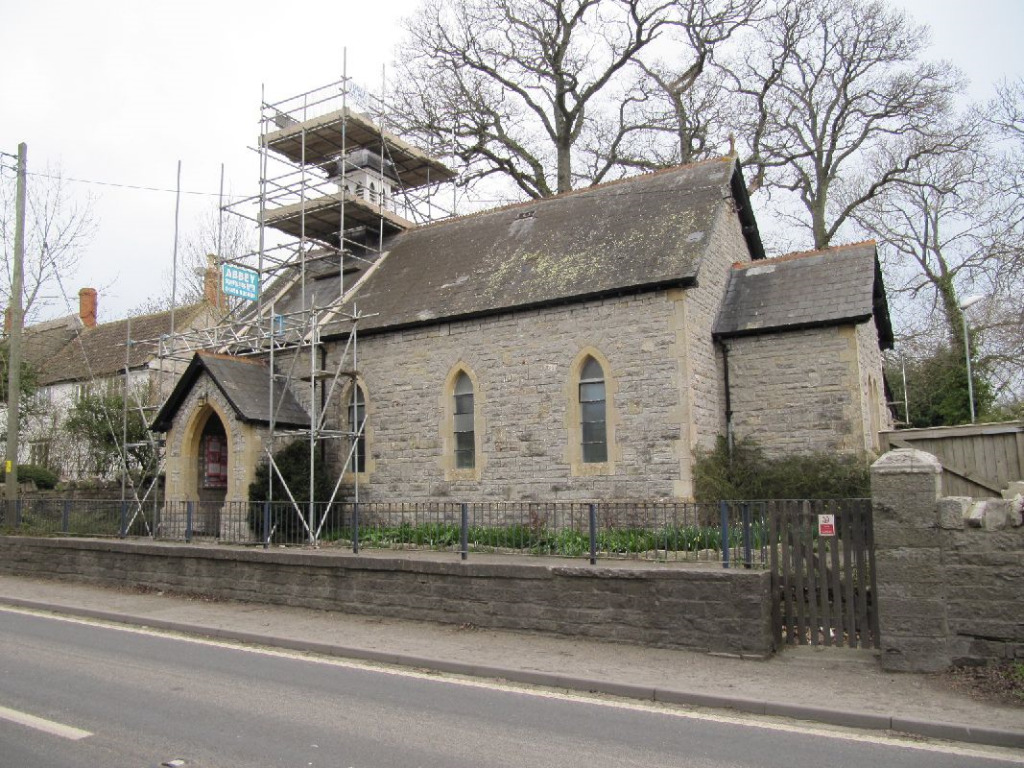
St Andrew's Church, Edgarley

St Andrew's Church is a former Church of England mission church in Edgarley, Somerset, England. It was built in 1897 and is now used as a private chapel...

Nearby Amenities

Located within 500m of 51.144882,-2.6982806
Barrier: kissing_gate
Lat/Long: 51.1454353/-2.696744
Barrier: kissing_gate
Lat/Long: 51.1431573/-2.7035905
Barrier: kissing_gate
Lat/Long: 51.143195/-2.6985774
Glastonbury Tor
Ele: 158
Natural: peak
Source: New Popular Edition
Wikidata: Q1412726
Lat/Long: 51.1446801/-2.6987699
Fixme: resurvey
Tourism: camp_site
Lat/Long: 51.1422968/-2.6928176
Living Rock
Archaeological Site: megalith
Historic: archaeological_site
Megalith Type: menhir
Lat/Long: 51.1430166/-2.7025977
Bench
Check Date: 2022-01-02
Lat/Long: 51.1436766/-2.7019889
Post Box
Brand: Royal Mail
Brand Wikidata: Q638098
Brand Wikipedia: en:Royal Mail
Operator: Royal Mail
Operator Wikidata: Q638098
Post Box Type: wall
Ref: BA6 113
Source: survey
Lat/Long: 51.14174/-2.70116
Barrier: kissing_gate
Lat/Long: 51.1466992/-2.6963567
Barrier: kissing_gate
Lat/Long: 51.1467786/-2.7022505
Barrier: kissing_gate
Lat/Long: 51.1464547/-2.7010569
Barrier: kissing_gate
Lat/Long: 51.1465524/-2.7036528
Bench
Lat/Long: 51.1454697/-2.6966154
Bench
Backrest: yes
Lat/Long: 51.1450951/-2.6976527
Bicycle Parking
Bicycle Parking: stands
Capacity: 8
Covered: no
Lat/Long: 51.1466871/-2.6962891
Bus Stop
Tor
Bus: yes
Naptan AtcoCode: 3600SOY38545
Naptan Bearing: E
Naptan CommonName: Tor
Naptan Indicator: E-bound
Naptan NaptanCode: sotdadgm
Naptan Verified: no
Public Transport: platform
Lat/Long: 51.1467518/-2.6953006
Bench
Lat/Long: 51.1467571/-2.6952077
Bench
Backrest: yes
Seats: 3
Lat/Long: 51.1468407/-2.6993418
Glastonbury Tor
Ele: 158
Tourism: viewpoint
Lat/Long: 51.1448295/-2.6984029
Holiday Cottage Glastonbury
Operator: https://glastonburycottagesandcaravanning.co.uk/
Tourism: camp_site
Website: https://glastonburycottagesandcaravanning.co.uk/
Lat/Long: 51.1417019/-2.6963982
Ele: 72.499474000000006
Source Ele: gpx
Lat/Long: 51.146739/-2.696212
Natural: shrub
Lat/Long: 51.1416626/-2.6967117
Natural: shrub
Lat/Long: 51.1438847/-2.7013868
Natural: shrub
Lat/Long: 51.1446587/-2.7007592
Natural: shrub
Lat/Long: 51.1437198/-2.7024812
Generator Method: photovoltaic
Generator Output Electricity: yes
Generator Source: solar
Generator Type: solar_photovoltaic_panel
Location: roof
Power: generator
Lat/Long: 51.1456911/-2.7032214
Generator Method: photovoltaic
Generator Output Electricity: yes
Generator Source: solar
Generator Type: solar_photovoltaic_panel
Location: roof
Power: generator
Lat/Long: 51.1457146/-2.7031678
Generator Method: photovoltaic
Generator Output Electricity: yes
Generator Source: solar
Generator Type: solar_photovoltaic_panel
Location: roof
Power: generator
Lat/Long: 51.145495/-2.7038384
The data included in this document is from www.openstreetmap.org. The data is made available under ODbL.

Have you been to Glastonbury Tor?

Leave your review of Glastonbury Tor below (or comments, questions and feedback).