Inchkeith Hill

Hill, Mountain in Berwickshire

Scotland

Inchkeith Hill

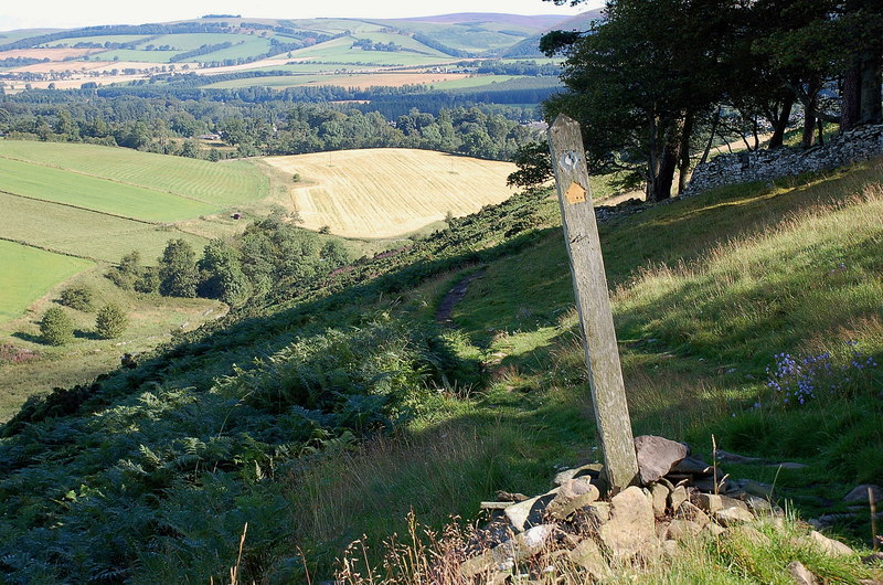
West of Collie Law View towards Kittyflat.
West of Collie Law Credit: Richard Webb

Inchkeith Hill is a prominent hill located in the county of Berwickshire, Scotland. Situated near the village of Inchkeith, the hill is an important landmark in the area. Rising to an elevation of approximately 180 meters (590 feet), it offers stunning panoramic views of the surrounding countryside and the North Sea.

Known for its natural beauty, Inchkeith Hill is covered in lush greenery, predominantly consisting of grasslands and heather. The hill is home to a diverse range of flora and fauna, making it a popular destination for nature enthusiasts and hikers. Visitors can explore several well-maintained walking trails that wind their way up the hill, providing opportunities to observe the local wildlife and enjoy the tranquil surroundings.

The hill holds historical significance as well. At its summit, the remains of an ancient hillfort can be found, dating back to the Iron Age. This archaeological site serves as a fascinating reminder of the area's rich history and attracts history buffs and archaeology enthusiasts.

Inchkeith Hill is easily accessible, with a car park located nearby, allowing visitors to conveniently reach its trails. The hill offers a peaceful retreat from the bustling city life, providing a serene environment for relaxation and recreation. Whether it be for a leisurely stroll or a challenging hike, Inchkeith Hill offers a memorable experience for nature lovers and history enthusiasts alike.

If you have any feedback on the listing, please let us know in the comments section below.

Inchkeith Hill Images

Images are sourced within 2km of 55.729265/-2.8246962 or Grid Reference NT4848. Thanks to Geograph Open Source API. All images are credited.

West of Collie Law View towards Kittyflat.
West of Collie Law
View towards Kittyflat.
Beside the Longmuir Burn Almost all the ridge between Oxton and Stow is part of the same estate and the track was made by fencers putting in a lot of new electric fencing. Fortunately there are lots of gates and I was only held up by temporary fences. The Scottish Borders Council Core paths map is very useful.
From here to Rowantree Law is rough and I was lucky to find the flattened track. Good timing!
Beside the Longmuir Burn
Almost all the ridge between Oxton and Stow is part of the same estate and the track was made by fencers putting in a lot of new electric fencing. Fortunately there are lots of gates and I was only held up by temporary fences. The Scottish Borders Council Core paths map is very useful. From here to Rowantree Law is rough and I was lucky to find the flattened track. Good timing!
Beside the Longmuir Burn
Pond, Longmuir Moss
Pond, Longmuir Moss
West side of Collie Law
Rowantree Law The mapped woodland has been felled. The foreground flattened grass is due to the recent renewal of fencing on the hill, nearly all electric. There is a road through the gates.
Rowantree Law
The mapped woodland has been felled. The foreground flattened grass is due to the recent renewal of fencing on the hill, nearly all electric. There is a road through the gates.
Felled woodland, Rowantree Law
New fence, Rowantree Law There has been a lot of fence restoration between Oxton and Stow, most of it electric.
New fence, Rowantree Law
There has been a lot of fence restoration between Oxton and Stow, most of it electric.
Dyking, Mitchelston Rebuilding a wall.
Dyking, Mitchelston
Rebuilding a wall.
Track, Mitchelston
Track, Mitchelston
New plantation, Tartan Hill Young trees above Cathpair.
New plantation, Tartan Hill
Young trees above Cathpair.
Girthgate The ridge is the line of an old pilgrimage route from Soutra Aisle to Melrose Abbey.
Girthgate
The ridge is the line of an old pilgrimage route from Soutra Aisle to Melrose Abbey.
New road, Cathpair The grassy path is the Girthgate which was unobstructed, unlike the new road over the dyke which had at least one pair of locked gates. The Girthgate, an old pilgrimage road is a very fine trip, especially in dry conditions.
New road, Cathpair
The grassy path is the Girthgate which was unobstructed, unlike the new road over the dyke which had at least one pair of locked gates. The Girthgate, an old pilgrimage road is a very fine trip, especially in dry conditions.
Cattle on the Girthgate
New road, Cathpair View over the dyke from the Girthgate of a very new road.
New road, Cathpair
View over the dyke from the Girthgate of a very new road.
Path on Scroof Hill A braiding in the Girthgate route.
Path on Scroof Hill
A braiding in the Girthgate route.
Scroof Hill With a new road. There has been a big expansion of the woodland here (west, Midlothian, side of the dyke). The eastern, Berwickshire side was still farmland, grazed by cattle.
Scroof Hill
With a new road. There has been a big expansion of the woodland here (west, Midlothian, side of the dyke). The eastern, Berwickshire side was still farmland, grazed by cattle.
Path on Scroof Hill Still farmed east of the dyke but over the wall there has been an expansion of woodland.
Path on Scroof Hill
Still farmed east of the dyke but over the wall there has been an expansion of woodland.
Show me another place!

Inchkeith Hill is located at Grid Ref: NT4848 (Lat: 55.729265, Lng: -2.8246962)

Unitary Authority: The Scottish Borders

Police Authority: The Lothians and Scottish Borders

What 3 Words

///typist.incorrect.contoured. Near Lauder, Scottish Borders

Related Wikis

Lauder railway station

Lauder railway station served the town of Lauder, Berwickshire, Scotland, from 1901 to 1958. It was situated on the Lauder Light Railway. == History... ==

Allanshaugh

Allanshaugh is a fermtoun in the Scottish Borders area of Scotland. == See also == List of places in the Scottish Borders List of places in Scotland...

Stow of Wedale Town Hall

Stow of Wedale Town Hall is a municipal building in Earlston Road, Stow of Wedale, Scottish Borders, Scotland. The structure, which serves as a community...

Lauderdale

Lauderdale is the valley of the Leader Water (a tributary of the Tweed) in the Scottish Borders. It contains the town of Lauder, as well as Earlston. The...

Nearby Amenities

Located within 500m of 55.729265,-2.8246962
Inchkeith Hill
Natural: peak
Lat/Long: 55.7291696/-2.8244542
Power: pole
Lat/Long: 55.7334246/-2.8246981
Power: pole
Lat/Long: 55.7327927/-2.8253496
Barrier: cattle_grid
Lat/Long: 55.7333016/-2.8246516
The data included in this document is from www.openstreetmap.org. The data is made available under ODbL.

Have you been to Inchkeith Hill?

Leave your review of Inchkeith Hill below (or comments, questions and feedback).