Hamdon Hill
Hill, Mountain in Somerset South Somerset
England
Hamdon Hill

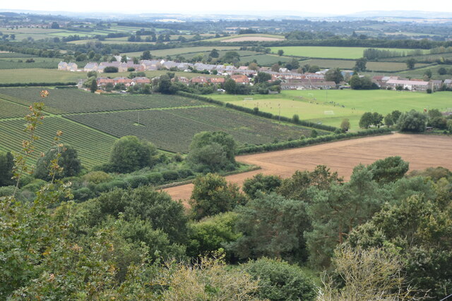
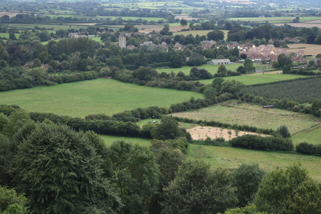
Hamdon Hill, located in Somerset, England, is a prominent hill standing at 154 meters (505 feet) above sea level. It is part of the Hamdon Hill Country Park, covering an area of approximately 200 hectares (494 acres). The hill is a notable landmark in the area, offering breathtaking panoramic views of the surrounding countryside.
The hill is formed by layers of limestone and shale, which provide a diverse range of habitats for various plant and animal species. The lower slopes are mainly covered with grassland, while the upper slopes are home to woodland areas composed of ash and hazel trees. This unique combination of habitats supports a rich biodiversity, attracting a wide array of wildlife.
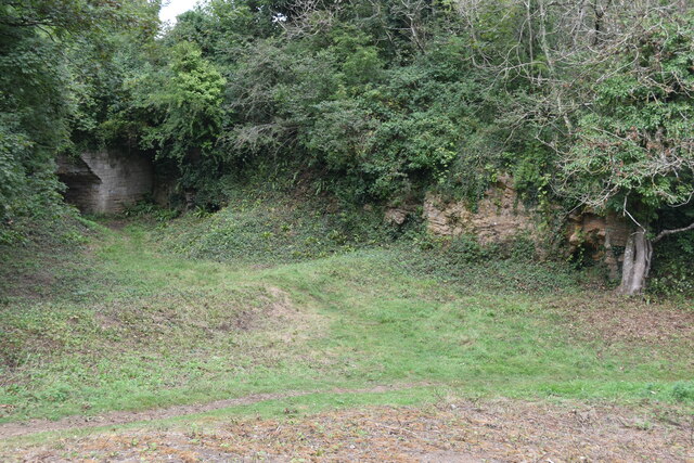
Hamdon Hill has a rich history dating back to the Iron Age, with evidence of human occupation found on the hilltop. The site is known for its Iron Age hillfort, which once served as a defensive settlement. The remains of ramparts and ditches can still be seen today, offering visitors a glimpse into the past.
The hill is a popular destination for outdoor enthusiasts and nature lovers, with numerous footpaths and trails for walking and hiking. It is also a favorite spot for birdwatchers, as the hill provides an opportunity to observe various bird species, including kestrels, buzzards, and peregrine falcons.
In addition to its natural and historical significance, Hamdon Hill offers a peaceful and tranquil atmosphere, making it an ideal place for relaxation and enjoying the stunning countryside views.
If you have any feedback on the listing, please let us know in the comments section below.
Hamdon Hill Images
Images are sourced within 2km of 50.947689/-2.7393354 or Grid Reference ST4816. Thanks to Geograph Open Source API. All images are credited.
![Montacute House & gardens [28] This is one of three flights of stairs into the sunken garden, the stairs set on the axes of the pool and fountain <a href="https://www.geograph.org.uk/photo/7521487">ST4917 : Montacute House &amp; gardens [29]</a>. Possibly 16th century in part, remodelled in the 19th century. Constructed of Ham stone ashlar. Listed, grade II, with details at: <span class="nowrap"><a title="https://historicengland.org.uk/listing/the-list/list-entry/1252024" rel="nofollow ugc noopener" href="https://historicengland.org.uk/listing/the-list/list-entry/1252024">Link</a><img style="margin-left:2px;" alt="External link" title="External link - shift click to open in new window" src="https://s1.geograph.org.uk/img/external.png" width="10" height="10"/></span>
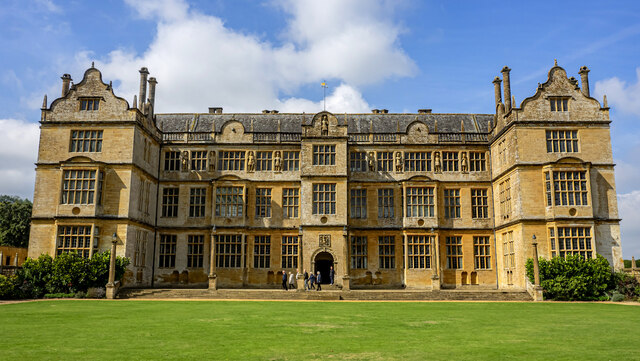
Montacute House was built circa 1590-1601 and substantially altered in 1785-87. Constructed, to an ‘H’ plan, of Ham stone ashlar under Welsh slate roofs behind open balustraded parapets. Originally the principal entrance was the east front, but this was changed when the west front was added in the late 18th century. The interior retains much 17th century decoration and features. Edward Phelips, the original builder, was a rich lawyer and the family occupied the house until the end of the 19th century. In 1931 the property was purchased by the Society for the Protection of Ancient Buildings and presented to the National Trust. Listed, grade I, with details at: <span class="nowrap"><a title="https://historicengland.org.uk/listing/the-list/list-entry/1252021" rel="nofollow ugc noopener" href="https://historicengland.org.uk/listing/the-list/list-entry/1252021">Link</a><img style="margin-left:2px;" alt="External link" title="External link - shift click to open in new window" src="https://s1.geograph.org.uk/img/external.png" width="10" height="10"/></span> The house sits within an estate of circa 270 acres (110ha) with about 10 acres (4ha) of formal gardens and pleasure grounds, the rest being parkland and ornamental plantations. The estate is on the Register of Historic Parks and Gardens, grade I, and there is much history and detail at: <span class="nowrap"><a title="https://historicengland.org.uk/listing/the-list/list-entry/1000468" rel="nofollow ugc noopener" href="https://historicengland.org.uk/listing/the-list/list-entry/1000468">Link</a><img style="margin-left:2px;" alt="External link" title="External link - shift click to open in new window" src="https://s1.geograph.org.uk/img/external.png" width="10" height="10"/></span>](https://s1.geograph.org.uk/geophotos/07/52/14/7521481_0fdc068e.jpg)


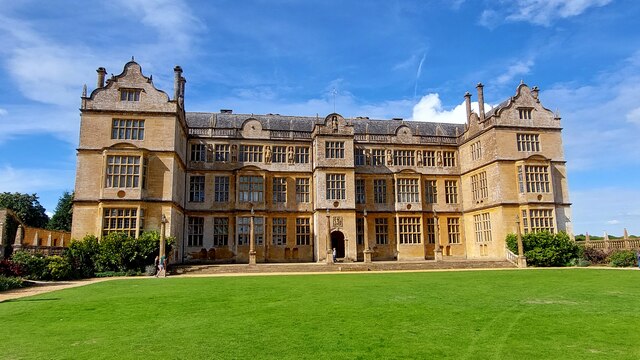

![Montacute House & gardens [22] The west front of the house.
Montacute House was built circa 1590-1601 and substantially altered in 1785-87. Constructed, to an ‘H’ plan, of Ham stone ashlar under Welsh slate roofs behind open balustraded parapets. Originally the principal entrance was the east front, but this was changed when the west front was added in the late 18th century. The interior retains much 17th century decoration and features. Edward Phelips, the original builder, was a rich lawyer and the family occupied the house until the end of the 19th century. In 1931 the property was purchased by the Society for the Protection of Ancient Buildings and presented to the National Trust. Listed, grade I, with details at: <span class="nowrap"><a title="https://historicengland.org.uk/listing/the-list/list-entry/1252021" rel="nofollow ugc noopener" href="https://historicengland.org.uk/listing/the-list/list-entry/1252021">Link</a><img style="margin-left:2px;" alt="External link" title="External link - shift click to open in new window" src="https://s1.geograph.org.uk/img/external.png" width="10" height="10"/></span> The house sits within an estate of circa 270 acres (110ha) with about 10 acres (4ha) of formal gardens and pleasure grounds, the rest being parkland and ornamental plantations. The estate is on the Register of Historic Parks and Gardens, grade I, and there is much history and detail at: <span class="nowrap"><a title="https://historicengland.org.uk/listing/the-list/list-entry/1000468" rel="nofollow ugc noopener" href="https://historicengland.org.uk/listing/the-list/list-entry/1000468">Link</a><img style="margin-left:2px;" alt="External link" title="External link - shift click to open in new window" src="https://s1.geograph.org.uk/img/external.png" width="10" height="10"/></span>](https://s0.geograph.org.uk/geophotos/07/52/14/7521452_958275d4.jpg)
Hamdon Hill is located at Grid Ref: ST4816 (Lat: 50.947689, Lng: -2.7393354)
Administrative County: Somerset
District: South Somerset
Police Authority: Avon and Somerset
What 3 Words
///kicks.variation.cages. Near Stoke-sub-Hamdon, Somerset
Nearby Locations
Related Wikis


Nearby Amenities
Located within 500m of 50.947689,-2.7393354Have you been to Hamdon Hill?
Leave your review of Hamdon Hill below (or comments, questions and feedback).