Ideford

Settlement in Devon Teignbridge

England

Ideford

Luton (Devon) Village amenities - the old telephone contains a book library and the roadside cabinet contains eggs and vegetables ("hedge veg") for sale.
Luton (Devon) Credit: Colin Smith

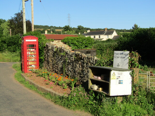
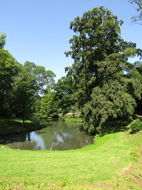
Ideford is a small rural village located in the county of Devon, England. Situated approximately 10 miles southwest of the city of Exeter, Ideford is nestled in the rolling countryside of the picturesque Teign Valley. The village is surrounded by lush green fields, meandering rivers, and charming woodlands, offering a tranquil and idyllic setting for its residents.

Despite its small size, Ideford boasts a rich history that can be traced back to medieval times. The village retains its traditional character with a cluster of old stone cottages and a quaint parish church, St. Mary's, which dates back to the 12th century. This historic church is a prominent feature of the village and attracts visitors interested in its architectural beauty and historical significance.

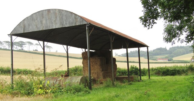
Ideford is primarily an agricultural community, with farming being the main occupation for many residents. The fertile soil and favorable climate in the area make it suitable for various crops, including cereals, vegetables, and fruits. Livestock farming, particularly sheep and cattle rearing, also plays a significant role in the local economy.

While Ideford may be a quiet village, it benefits from its close proximity to the nearby towns and cities. Residents can easily access the amenities and services offered in Exeter, including schools, shops, and healthcare facilities. The village is also a popular destination for nature enthusiasts and hikers, thanks to its proximity to Dartmoor National Park and the stunning Teign Valley, which provide ample opportunities for outdoor activities such as walking, cycling, and wildlife spotting.

Overall, Ideford offers a peaceful and charming countryside retreat, with its historic charm, agricultural heritage, and natural beauty making it an attractive place to live or visit.

If you have any feedback on the listing, please let us know in the comments section below.

Ideford Images

Images are sourced within 2km of 50.584869/-3.565806 or Grid Reference SX8977. Thanks to Geograph Open Source API. All images are credited.

Luton (Devon) Village amenities - the old telephone contains a book library and the roadside cabinet contains eggs and vegetables ("hedge veg") for sale.
Luton (Devon)
Village amenities - the old telephone contains a book library and the roadside cabinet contains eggs and vegetables ("hedge veg") for sale.
Luton (Devon) - Church Luton has a chapel of ease, dedicated to St John the Evangelist, built in the 19th century.
Luton (Devon) - Church
Luton has a chapel of ease, dedicated to St John the Evangelist, built in the 19th century.
Luton (Devon) Valley with grassland and woodland by Cherrycombe.
Luton (Devon)
Valley with grassland and woodland by Cherrycombe.
Luton - Lane Hedge-lined lane in deepest Devon, close to Westhayes Farm, a dairy farm.
Luton - Lane
Hedge-lined lane in deepest Devon, close to Westhayes Farm, a dairy farm.
Luton (Devon) - Dutch Barn A barrel roof but no walls. Dutch barns are a relatively recent feature in British farm architecture, most dating from the 19th century. Nowadays they are more commonly used to store hay and straw.
Luton (Devon) - Dutch Barn
A barrel roof but no walls. Dutch barns are a relatively recent feature in British farm architecture, most dating from the 19th century. Nowadays they are more commonly used to store hay and straw.
Humber - Humber Barn Patchwork of cereal fields lined by hedgerows with Humber Barn nestling in a valley on the hillside.
Humber - Humber Barn
Patchwork of cereal fields lined by hedgerows with Humber Barn nestling in a valley on the hillside.
Luton - Hayes Farm Farmhouse and holiday cottages surrounded by a patchwork of hedgerow-lined fields.
Luton - Hayes Farm
Farmhouse and holiday cottages surrounded by a patchwork of hedgerow-lined fields.
Luton - Hayes Farm Farmhouse and holiday cottages surrounded by a patchwork of hedgerow-lined fields.
Luton - Hayes Farm
Farmhouse and holiday cottages surrounded by a patchwork of hedgerow-lined fields.
Luton (Devon) - The Elizabethan A cosy Devon village pub which sources local food from the farming community.
<span class="nowrap"><a title="www.elizabethaninn.co.uk" rel="nofollow ugc noopener" href="http://www.elizabethaninn.co.uk">Link</a><img style="margin-left:2px;" alt="External link" title="External link - shift click to open in new window" src="https://s1.geograph.org.uk/img/external.png" width="10" height="10"/></span>
Luton (Devon) - The Elizabethan
A cosy Devon village pub which sources local food from the farming community. LinkExternal link
Luton - Hayes Farm Mews Entrance to holiday accommodation at Hayes Farm, a dairy farm.
Luton - Hayes Farm Mews
Entrance to holiday accommodation at Hayes Farm, a dairy farm.
Ugbrooke House - Pond Pond by the entrance to the stately home of Baron Clifford of Chudleigh.
<span class="nowrap"><a title="www.ugbrooke.co.uk" rel="nofollow ugc noopener" href="http://www.ugbrooke.co.uk">Link</a><img style="margin-left:2px;" alt="External link" title="External link - shift click to open in new window" src="https://s1.geograph.org.uk/img/external.png" width="10" height="10"/></span>
Ugbrooke House - Pond
Pond by the entrance to the stately home of Baron Clifford of Chudleigh. LinkExternal link
Not so Old Boundary Marker on the A380 in Kingsteignton parish Parish Boundary Marker located on the west side of the A380 beside the slip road leading to Gappah Lane. Inscribed I, C, K and K on its four faces it marks the meeting of Chudleigh, Ideford and Kingsteignton parishes, although it is at little way from the actual point at SX 87595 77363. It looks like a modern replacement perhaps erected when the A380 was improved in about 1980. See also <span class="nowrap"><a title="http://www.msocrepository.co.uk/images/boundary_marker/DV_EXDC01pb.jpg" rel="nofollow ugc noopener" href="http://www.msocrepository.co.uk/images/boundary_marker/DV_EXDC01pb.jpg">Link</a><img style="margin-left:2px;" alt="External link" title="External link - shift click to open in new window" src="https://s1.geograph.org.uk/img/external.png" width="10" height="10"/></span>.

Milestone Society National ID: DV_EXTN12pb
Not so Old Boundary Marker on the A380 in Kingsteignton parish
Parish Boundary Marker located on the west side of the A380 beside the slip road leading to Gappah Lane. Inscribed I, C, K and K on its four faces it marks the meeting of Chudleigh, Ideford and Kingsteignton parishes, although it is at little way from the actual point at SX 87595 77363. It looks like a modern replacement perhaps erected when the A380 was improved in about 1980. See also LinkExternal link. Milestone Society National ID: DV_EXTN12pb
Luton - Rocky Hill Path showing the underlying red rock - sandstone.
Luton - Rocky Hill
Path showing the underlying red rock - sandstone.
Luton (Devon) A patchwork of hedgerow-lined fields on a hillside near Luton. Dartmoor is on the skyline.
Luton (Devon)
A patchwork of hedgerow-lined fields on a hillside near Luton. Dartmoor is on the skyline.
Ideford - The Royal Oak The Royal Oak is an historic village pub, ca late 17th century building with a thatched roof.
Ideford - The Royal Oak
The Royal Oak is an historic village pub, ca late 17th century building with a thatched roof.
Luton - Westhayes Farm Newborn calves on the dairy farm.
Luton - Westhayes Farm
Newborn calves on the dairy farm.
Luton (Devon) Newborn calves tucking in at one of their first feeding times on the dairy farm.
Luton (Devon)
Newborn calves tucking in at one of their first feeding times on the dairy farm.
Show me another place!

Ideford is located at Grid Ref: SX8977 (Lat: 50.584869, Lng: -3.565806)

Administrative County: Devon

District: Teignbridge

Police Authority: Devon and Cornwall

What 3 Words

///rejoined.diets.harder. Near Chudleigh, Devon

Related Wikis

Ideford

Ideford (or Ideford Parish) is a village in the Teignbridge district of Devon, England. It is 5 miles (8 km) north of Newton Abbot. To the west is the...

Luton, Teignbridge

Luton is a village in Devon, England, within Teignbridge local authority area. Historically Luton formed part of Ashcombe Hundred.The village is in the...

Ideford Common

Ideford Common is a Site of Special Scientific Interest consisting of an area of lowland heath in Devon, England. The site is a habitat for nightjars and...
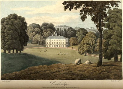
Lindridge House

Lindridge House was a large 17th-century mansion (with 20th-century alterations), one of the finest in the south-west situated about 1 mile south of Ideford...

Olchard

Olchard is a village in Devon, England.

Ugbrooke

Ugbrooke House is a stately home in the parish of Chudleigh, Devon, England, situated in a valley between Exeter and Newton Abbot. The home of the Clifford...

Ashcombe

Ashcombe is a village and civil parish in the Teignbridge district of Devon, England, about eight miles south of the city of Exeter. The parish is surrounded...

Haldon Aerodrome

Haldon Aerodrome was the first airfield in Devon. Established in the 1920s as a private flying field, it developed into an airport with scheduled airline...

Nearby Amenities

Located within 500m of 50.584869,-3.565806
Ideford
Place: village
Lat/Long: 50.5851025/-3.5661706
Ideford Garage
Brand: All
Fuel: no
Opening Hours: Mo-Fr 07:30-17:30; Sa 08:30-13:00
Phone: +44 1626 852256
Shop: tyres
Lat/Long: 50.5848712/-3.5652061
Hayes Farm Riding Stables
Sport: equestrian
Lat/Long: 50.5857398/-3.5675343
Post Box
Brand: Royal Mail
Brand Wikidata: Q638098
Collection Times: Mo-Fr 16:00; Sa 09:30; Su off
Drive Through: no
Operator: Royal Mail
Operator Wikidata: Q638098
Post Box Design: 2010_pattern
Post Box Mounting: pier
Post Box Type: lamp
Ref: TQ13 281
Royal Cypher: EIIR
Royal Cypher Wikidata: Q33102113
Source: survey;local knowledge;aerial imagery;streetlevel imagery
Lat/Long: 50.5849355/-3.5656634
Pub
The Royal Oak
Lat/Long: 50.5849545/-3.5657657
Power: pole
Lat/Long: 50.5881378/-3.5618717
Power: pole
Lat/Long: 50.5879301/-3.56332
Power: pole
Lat/Long: 50.5877326/-3.564806
Power: pole
Lat/Long: 50.5874873/-3.5665923
Power: pole
Lat/Long: 50.5872608/-3.5683492
Power: pole
Lat/Long: 50.5870497/-3.5698512
Power: pole
Lat/Long: 50.5867619/-3.5720453
Generator Method: photovoltaic
Generator Output Electricity: yes
Generator Source: solar
Generator Type: solar_photovoltaic_panel
Location: roof
Power: generator
Lat/Long: 50.586675/-3.5622767
Generator Method: photovoltaic
Generator Output Electricity: yes
Generator Source: solar
Generator Type: solar_photovoltaic_panel
Location: roof
Power: generator
Lat/Long: 50.5862646/-3.5622686
Generator Method: photovoltaic
Generator Output Electricity: yes
Generator Source: solar
Generator Type: solar_photovoltaic_panel
Location: roof
Power: generator
Lat/Long: 50.5857384/-3.5675928
Generator Method: photovoltaic
Generator Output Electricity: yes
Generator Source: solar
Generator Type: solar_photovoltaic_panel
Location: roof
Power: generator
Lat/Long: 50.5851721/-3.5643178
Generator Method: photovoltaic
Generator Output Electricity: yes
Generator Source: solar
Generator Type: solar_photovoltaic_panel
Location: roof
Power: generator
Lat/Long: 50.5849967/-3.5644747
Generator Method: photovoltaic
Generator Output Electricity: yes
Generator Source: solar
Generator Type: solar_photovoltaic_panel
Location: roof
Power: generator
Lat/Long: 50.5839928/-3.5627823
Generator Method: photovoltaic
Generator Output Electricity: yes
Generator Source: solar
Generator Type: solar_photovoltaic_panel
Location: roof
Power: generator
Lat/Long: 50.5839945/-3.5630116
Generator Method: photovoltaic
Generator Output Electricity: yes
Generator Source: solar
Generator Type: solar_photovoltaic_panel
Location: roof
Power: generator
Lat/Long: 50.583871/-3.5631564
Generator Method: photovoltaic
Generator Output Electricity: yes
Generator Source: solar
Generator Type: solar_photovoltaic_panel
Location: roof
Power: generator
Lat/Long: 50.5839383/-3.5642856
Generator Method: photovoltaic
Generator Output Electricity: yes
Generator Source: solar
Generator Type: solar_photovoltaic_panel
Location: roof
Power: generator
Lat/Long: 50.5844407/-3.5650608
Power: pole
Lat/Long: 50.5812986/-3.562656
Power: pole
Lat/Long: 50.5813073/-3.5636347
Power: pole
Lat/Long: 50.5813029/-3.5644633
Power: pole
Lat/Long: 50.5812833/-3.5655256
Power: pole
Lat/Long: 50.5812352/-3.5669111
Power: pole
Lat/Long: 50.5812287/-3.5675609
Power: pole
Lat/Long: 50.581209/-3.5690771
Power: pole
Lat/Long: 50.5813163/-3.5615364
The data included in this document is from www.openstreetmap.org. The data is made available under ODbL.

Have you been to Ideford?

Leave your review of Ideford below (or comments, questions and feedback).