Percombe Hill
Hill, Mountain in Somerset South Somerset
England
Percombe Hill
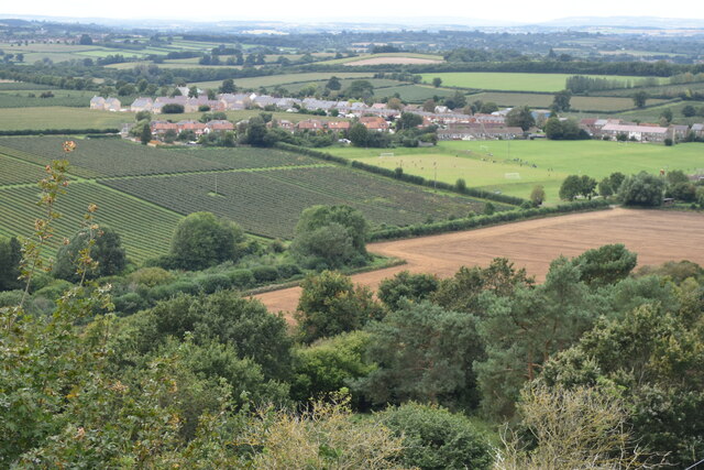
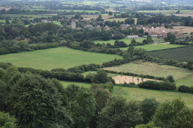
Percombe Hill is a prominent hill located in Somerset, a county in the southwestern part of England. It stands at an elevation of approximately 212 meters (696 feet) above sea level, making it a notable landmark in the region. The hill is situated near the village of Puckington and overlooks the picturesque countryside of Somerset.
Percombe Hill is renowned for its beautiful panoramic views, offering visitors a stunning vista of the surrounding landscape. From its summit, one can see lush green fields, rolling hills, and quaint villages that dot the countryside. On clear days, it is even possible to catch a glimpse of the Bristol Channel in the distance.
The hill itself is composed of sedimentary rocks, primarily limestone and sandstone, which are characteristic of the area. These rocks have been shaped by erosion over millions of years, giving the hill its distinct features and contours.
Percombe Hill is a popular destination for hikers and nature enthusiasts, who are drawn to its scenic beauty and tranquil atmosphere. Several footpaths and trails traverse the hill, providing opportunities for leisurely walks and exploration of the surrounding countryside.
The hill is also home to a diverse range of flora and fauna, with wildflowers blooming in the spring and summer months, and a variety of bird species inhabiting the area. It is a designated Site of Special Scientific Interest (SSSI), recognized for its ecological importance and geological significance.
Overall, Percombe Hill in Somerset is a captivating natural landmark that offers visitors a chance to immerse themselves in the beauty of the English countryside while enjoying stunning views and a peaceful ambiance.
If you have any feedback on the listing, please let us know in the comments section below.
Percombe Hill Images
Images are sourced within 2km of 50.954198/-2.7647806 or Grid Reference ST4617. Thanks to Geograph Open Source API. All images are credited.


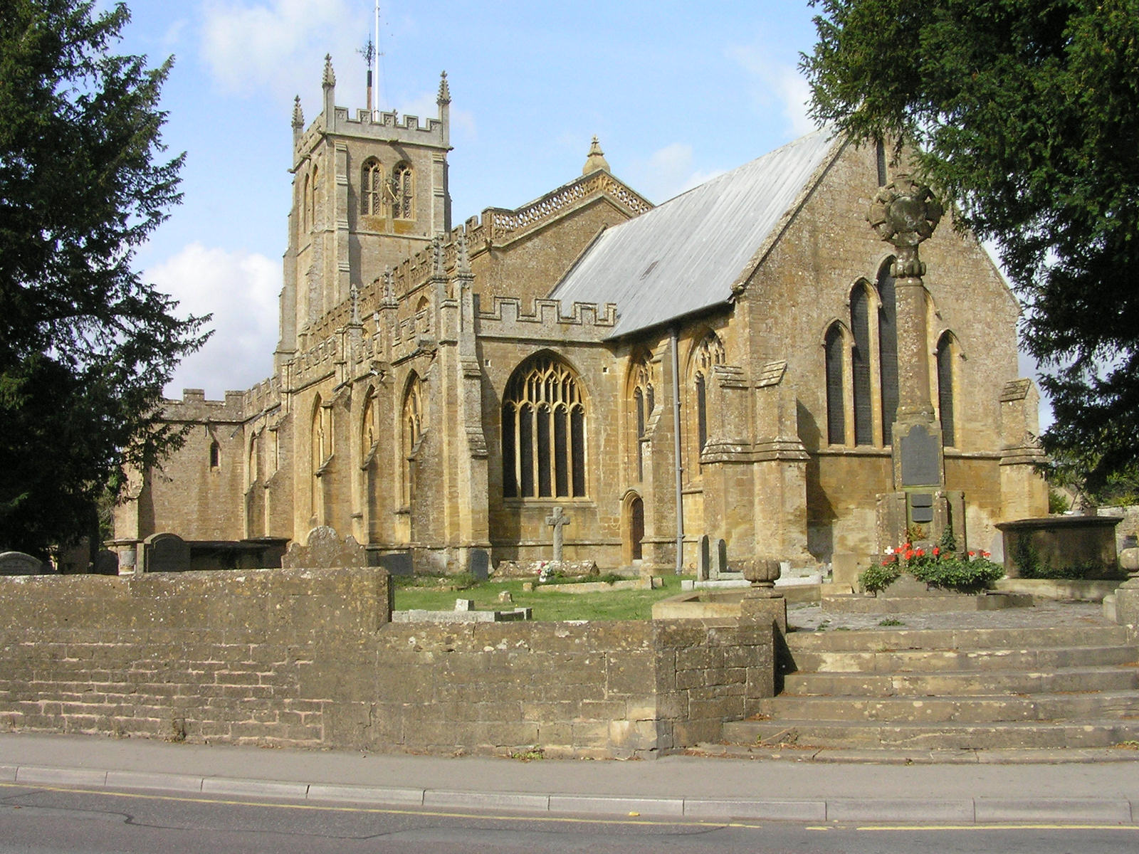
![Martock houses [1] The Treasurers House is a medieval priest's house. Originally built in the 13th century, with 14th, 15th and 19th century extensions. Constructed of coursed Ham stone rubble with some ashlar work and dressings under double Roman tile roofs.
Built in a &#039;T&#039; plan, the projecting wing is the early 14th century hall, the cross wing is early 13th century with a small early 19th century extension. The late 15th or early 16th century kitchen has no direct link to the house. Many early internal features and fittings remain, including a 4-bay moulded arched collar-truss roof and a 4-panel deep moulded beam ceiling. The Treasurer of Wells Cathedral became rector and patron of Martock 1227-8 and the house is first mentioned in 1226. The plot was enlarged in 1262, and the hall added in 1293-94. It remained part of the manor of Martock Rectory until it was sold in 1840. It was then in private hands until it was left to the National Trust in 1970. Listed, grade I, with details at: <span class="nowrap"><a title="https://historicengland.org.uk/listing/the-list/list-entry/1225764" rel="nofollow ugc noopener" href="https://historicengland.org.uk/listing/the-list/list-entry/1225764">Link</a><img style="margin-left:2px;" alt="External link" title="External link - shift click to open in new window" src="https://s1.geograph.org.uk/img/external.png" width="10" height="10"/></span>
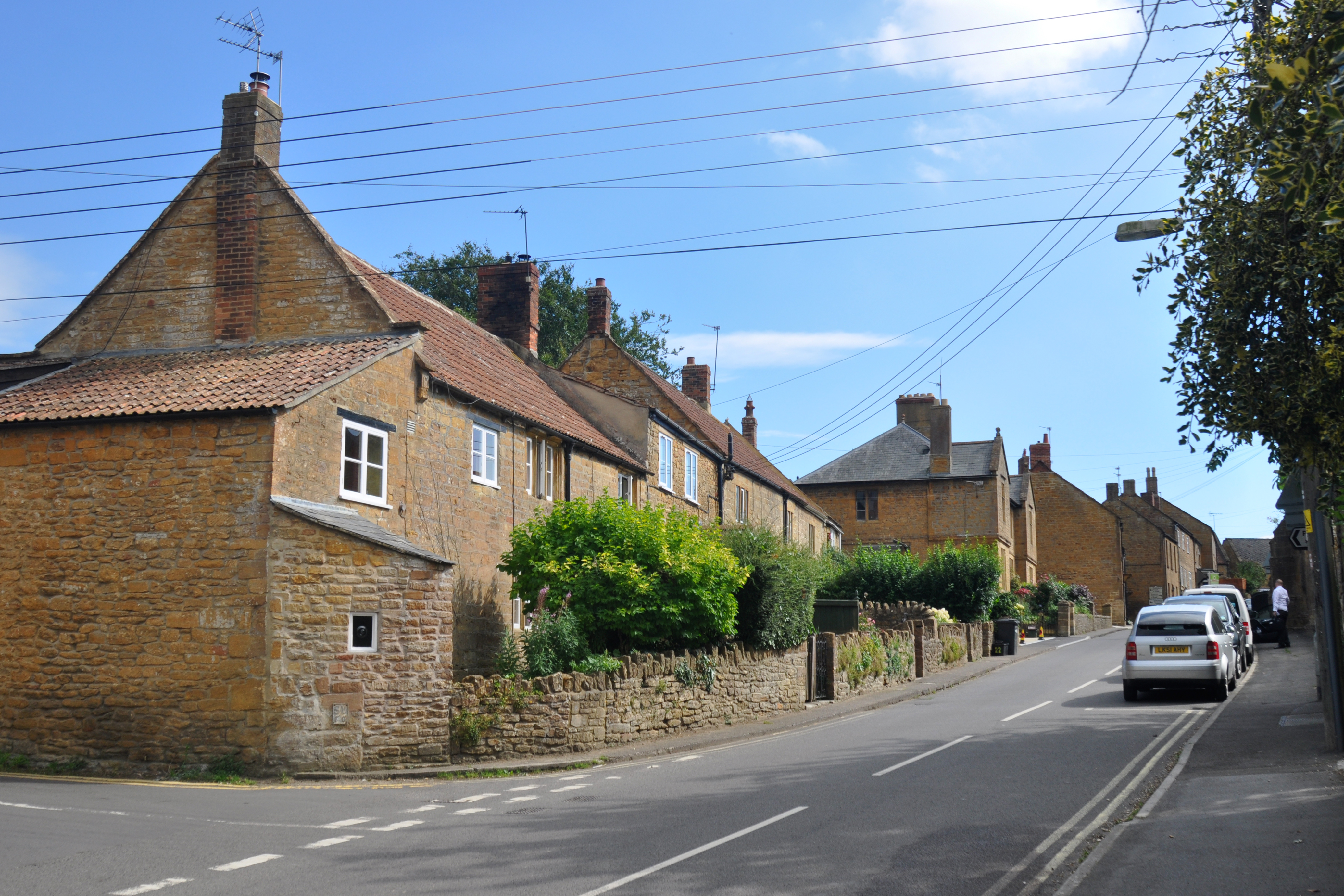
Martock is a large village in Somerset, situated on the edge of the Somerset Levels, about 6¼ miles northwest of Yeovil and some 15 miles southeast of Taunton. Martock was known in the Domesday Book of 1086 as Mertoch meaning &#039;Rising bright from the shining sea&#039; from the Old English &#039;meretorht&#039;. The village is a former market town and is home to the Treasurers House, one of the oldest domestic dwellings in England, and an outstanding 13th century church with a magnificent carved king-post truss roof.](https://s2.geograph.org.uk/geophotos/07/51/95/7519554_67ee7a78.jpg)
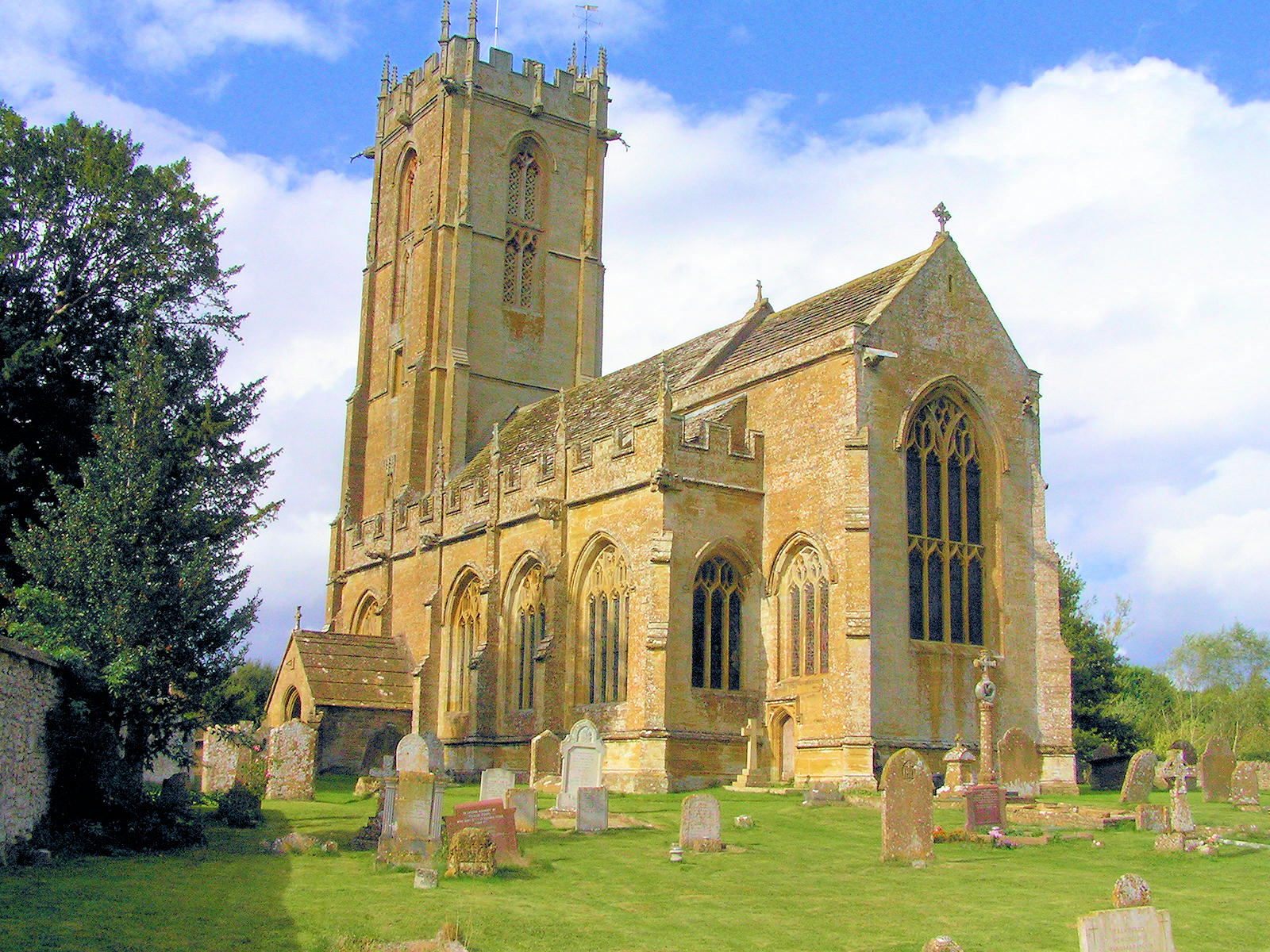
![Parish church [1] With Saxon origins, the Anglican parish church of All Saints was built in the 13th century. In the 15th century the tower was built replacing an earlier one over the central crossing. At the same time the rest of the church was restored and expanded. The church was restored in 1860 and again in 1884. Constructed of Ham stone ashlar under lead roofs. The nave has a magnificent carved king-post truss roof of 1513. Listed, grade I, with details at: <span class="nowrap"><a title="https://historicengland.org.uk/listing/the-list/list-entry/1065888" rel="nofollow ugc noopener" href="https://historicengland.org.uk/listing/the-list/list-entry/1065888">Link</a><img style="margin-left:2px;" alt="External link" title="External link - shift click to open in new window" src="https://s1.geograph.org.uk/img/external.png" width="10" height="10"/></span>
Martock is a large village in Somerset, situated on the edge of the Somerset Levels, about 6¼ miles northwest of Yeovil and some 15 miles southeast of Taunton. Martock was known in the Domesday Book of 1086 as Mertoch meaning &#039;Rising bright from the shining sea&#039; from the Old English &#039;meretorht&#039;. The village is a former market town and is home to the Treasurers House, one of the oldest domestic dwellings in England, and an outstanding 13th century church with a magnificent carved king-post truss roof.](https://s1.geograph.org.uk/geophotos/07/51/95/7519581_7c470752.jpg)
![Parish church [2] The nave roof.
With Saxon origins, the Anglican parish church of All Saints was built in the 13th century. In the 15th century the tower was built replacing an earlier one over the central crossing. At the same time the rest of the church was restored and expanded. The church was restored in 1860 and again in 1884. Constructed of Ham stone ashlar under lead roofs. The nave has a magnificent carved king-post truss roof of 1513. Listed, grade I, with details at: <span class="nowrap"><a title="https://historicengland.org.uk/listing/the-list/list-entry/1065888" rel="nofollow ugc noopener" href="https://historicengland.org.uk/listing/the-list/list-entry/1065888">Link</a><img style="margin-left:2px;" alt="External link" title="External link - shift click to open in new window" src="https://s1.geograph.org.uk/img/external.png" width="10" height="10"/></span>
Martock is a large village in Somerset, situated on the edge of the Somerset Levels, about 6¼ miles northwest of Yeovil and some 15 miles southeast of Taunton. Martock was known in the Domesday Book of 1086 as Mertoch meaning &#039;Rising bright from the shining sea&#039; from the Old English &#039;meretorht&#039;. The village is a former market town and is home to the Treasurers House, one of the oldest domestic dwellings in England, and an outstanding 13th century church with a magnificent carved king-post truss roof.](https://s0.geograph.org.uk/geophotos/07/51/95/7519584_389cad2f.jpg)
![Parish church [3] The nave.
With Saxon origins, the Anglican parish church of All Saints was built in the 13th century. In the 15th century the tower was built replacing an earlier one over the central crossing. At the same time the rest of the church was restored and expanded. The church was restored in 1860 and again in 1884. Constructed of Ham stone ashlar under lead roofs. The nave has a magnificent carved king-post truss roof of 1513. Listed, grade I, with details at: <span class="nowrap"><a title="https://historicengland.org.uk/listing/the-list/list-entry/1065888" rel="nofollow ugc noopener" href="https://historicengland.org.uk/listing/the-list/list-entry/1065888">Link</a><img style="margin-left:2px;" alt="External link" title="External link - shift click to open in new window" src="https://s1.geograph.org.uk/img/external.png" width="10" height="10"/></span>
Martock is a large village in Somerset, situated on the edge of the Somerset Levels, about 6¼ miles northwest of Yeovil and some 15 miles southeast of Taunton. Martock was known in the Domesday Book of 1086 as Mertoch meaning &#039;Rising bright from the shining sea&#039; from the Old English &#039;meretorht&#039;. The village is a former market town and is home to the Treasurers House, one of the oldest domestic dwellings in England, and an outstanding 13th century church with a magnificent carved king-post truss roof.](https://s2.geograph.org.uk/geophotos/07/51/95/7519586_f46910f1.jpg)
![Parish church [4] The chancel.
With Saxon origins, the Anglican parish church of All Saints was built in the 13th century. In the 15th century the tower was built replacing an earlier one over the central crossing. At the same time the rest of the church was restored and expanded. The church was restored in 1860 and again in 1884. Constructed of Ham stone ashlar under lead roofs. The nave has a magnificent carved king-post truss roof of 1513. Listed, grade I, with details at: <span class="nowrap"><a title="https://historicengland.org.uk/listing/the-list/list-entry/1065888" rel="nofollow ugc noopener" href="https://historicengland.org.uk/listing/the-list/list-entry/1065888">Link</a><img style="margin-left:2px;" alt="External link" title="External link - shift click to open in new window" src="https://s1.geograph.org.uk/img/external.png" width="10" height="10"/></span>
Martock is a large village in Somerset, situated on the edge of the Somerset Levels, about 6¼ miles northwest of Yeovil and some 15 miles southeast of Taunton. Martock was known in the Domesday Book of 1086 as Mertoch meaning &#039;Rising bright from the shining sea&#039; from the Old English &#039;meretorht&#039;. The village is a former market town and is home to the Treasurers House, one of the oldest domestic dwellings in England, and an outstanding 13th century church with a magnificent carved king-post truss roof.](https://s0.geograph.org.uk/geophotos/07/51/95/7519588_818c7c18.jpg)
![Parish church [5] The organ.
With Saxon origins, the Anglican parish church of All Saints was built in the 13th century. In the 15th century the tower was built replacing an earlier one over the central crossing. At the same time the rest of the church was restored and expanded. The church was restored in 1860 and again in 1884. Constructed of Ham stone ashlar under lead roofs. The nave has a magnificent carved king-post truss roof of 1513. Listed, grade I, with details at: <span class="nowrap"><a title="https://historicengland.org.uk/listing/the-list/list-entry/1065888" rel="nofollow ugc noopener" href="https://historicengland.org.uk/listing/the-list/list-entry/1065888">Link</a><img style="margin-left:2px;" alt="External link" title="External link - shift click to open in new window" src="https://s1.geograph.org.uk/img/external.png" width="10" height="10"/></span>
Martock is a large village in Somerset, situated on the edge of the Somerset Levels, about 6¼ miles northwest of Yeovil and some 15 miles southeast of Taunton. Martock was known in the Domesday Book of 1086 as Mertoch meaning &#039;Rising bright from the shining sea&#039; from the Old English &#039;meretorht&#039;. The village is a former market town and is home to the Treasurers House, one of the oldest domestic dwellings in England, and an outstanding 13th century church with a magnificent carved king-post truss roof.](https://s2.geograph.org.uk/geophotos/07/51/95/7519594_b89deb93.jpg)
![Parish church [6] The 15th century octagonal font.
With Saxon origins, the Anglican parish church of All Saints was built in the 13th century. In the 15th century the tower was built replacing an earlier one over the central crossing. At the same time the rest of the church was restored and expanded. The church was restored in 1860 and again in 1884. Constructed of Ham stone ashlar under lead roofs. The nave has a magnificent carved king-post truss roof of 1513. Listed, grade I, with details at: <span class="nowrap"><a title="https://historicengland.org.uk/listing/the-list/list-entry/1065888" rel="nofollow ugc noopener" href="https://historicengland.org.uk/listing/the-list/list-entry/1065888">Link</a><img style="margin-left:2px;" alt="External link" title="External link - shift click to open in new window" src="https://s1.geograph.org.uk/img/external.png" width="10" height="10"/></span>
Martock is a large village in Somerset, situated on the edge of the Somerset Levels, about 6¼ miles northwest of Yeovil and some 15 miles southeast of Taunton. Martock was known in the Domesday Book of 1086 as Mertoch meaning &#039;Rising bright from the shining sea&#039; from the Old English &#039;meretorht&#039;. The village is a former market town and is home to the Treasurers House, one of the oldest domestic dwellings in England, and an outstanding 13th century church with a magnificent carved king-post truss roof.](https://s3.geograph.org.uk/geophotos/07/51/95/7519595_d53bc3d3.jpg)
![Parish church [7] A low tomb arch containing a worn female effigy, probably early 14th century.
With Saxon origins, the Anglican parish church of All Saints was built in the 13th century. In the 15th century the tower was built replacing an earlier one over the central crossing. At the same time the rest of the church was restored and expanded. The church was restored in 1860 and again in 1884. Constructed of Ham stone ashlar under lead roofs. The nave has a magnificent carved king-post truss roof of 1513. Listed, grade I, with details at: <span class="nowrap"><a title="https://historicengland.org.uk/listing/the-list/list-entry/1065888" rel="nofollow ugc noopener" href="https://historicengland.org.uk/listing/the-list/list-entry/1065888">Link</a><img style="margin-left:2px;" alt="External link" title="External link - shift click to open in new window" src="https://s1.geograph.org.uk/img/external.png" width="10" height="10"/></span>
Martock is a large village in Somerset, situated on the edge of the Somerset Levels, about 6¼ miles northwest of Yeovil and some 15 miles southeast of Taunton. Martock was known in the Domesday Book of 1086 as Mertoch meaning &#039;Rising bright from the shining sea&#039; from the Old English &#039;meretorht&#039;. The village is a former market town and is home to the Treasurers House, one of the oldest domestic dwellings in England, and an outstanding 13th century church with a magnificent carved king-post truss roof.](https://s0.geograph.org.uk/geophotos/07/51/95/7519596_6cda3c4a.jpg)
![Parish church [8] The tower arch and west window.
With Saxon origins, the Anglican parish church of All Saints was built in the 13th century. In the 15th century the tower was built replacing an earlier one over the central crossing. At the same time the rest of the church was restored and expanded. The church was restored in 1860 and again in 1884. Constructed of Ham stone ashlar under lead roofs. The nave has a magnificent carved king-post truss roof of 1513. Listed, grade I, with details at: <span class="nowrap"><a title="https://historicengland.org.uk/listing/the-list/list-entry/1065888" rel="nofollow ugc noopener" href="https://historicengland.org.uk/listing/the-list/list-entry/1065888">Link</a><img style="margin-left:2px;" alt="External link" title="External link - shift click to open in new window" src="https://s1.geograph.org.uk/img/external.png" width="10" height="10"/></span>
Martock is a large village in Somerset, situated on the edge of the Somerset Levels, about 6¼ miles northwest of Yeovil and some 15 miles southeast of Taunton. Martock was known in the Domesday Book of 1086 as Mertoch meaning &#039;Rising bright from the shining sea&#039; from the Old English &#039;meretorht&#039;. The village is a former market town and is home to the Treasurers House, one of the oldest domestic dwellings in England, and an outstanding 13th century church with a magnificent carved king-post truss roof.](https://s2.geograph.org.uk/geophotos/07/52/05/7520522_368422ec.jpg)
![Parish church [9] Part of the churchyard which has over 30 listed monuments.
With Saxon origins, the Anglican parish church of All Saints was built in the 13th century. In the 15th century the tower was built replacing an earlier one over the central crossing. At the same time the rest of the church was restored and expanded. The church was restored in 1860 and again in 1884. Constructed of Ham stone ashlar under lead roofs. The nave has a magnificent carved king-post truss roof of 1513. Listed, grade I, with details at: <span class="nowrap"><a title="https://historicengland.org.uk/listing/the-list/list-entry/1065888" rel="nofollow ugc noopener" href="https://historicengland.org.uk/listing/the-list/list-entry/1065888">Link</a><img style="margin-left:2px;" alt="External link" title="External link - shift click to open in new window" src="https://s1.geograph.org.uk/img/external.png" width="10" height="10"/></span>
Martock is a large village in Somerset, situated on the edge of the Somerset Levels, about 6¼ miles northwest of Yeovil and some 15 miles southeast of Taunton. Martock was known in the Domesday Book of 1086 as Mertoch meaning &#039;Rising bright from the shining sea&#039; from the Old English &#039;meretorht&#039;. The village is a former market town and is home to the Treasurers House, one of the oldest domestic dwellings in England, and an outstanding 13th century church with a magnificent carved king-post truss roof.](https://s3.geograph.org.uk/geophotos/07/52/05/7520523_8aec442d.jpg)
![Parish church [10] Part of the churchyard which has over 30 listed monuments.
With Saxon origins, the Anglican parish church of All Saints was built in the 13th century. In the 15th century the tower was built replacing an earlier one over the central crossing. At the same time the rest of the church was restored and expanded. The church was restored in 1860 and again in 1884. Constructed of Ham stone ashlar under lead roofs. The nave has a magnificent carved king-post truss roof of 1513. Listed, grade I, with details at: <span class="nowrap"><a title="https://historicengland.org.uk/listing/the-list/list-entry/1065888" rel="nofollow ugc noopener" href="https://historicengland.org.uk/listing/the-list/list-entry/1065888">Link</a><img style="margin-left:2px;" alt="External link" title="External link - shift click to open in new window" src="https://s1.geograph.org.uk/img/external.png" width="10" height="10"/></span>
Martock is a large village in Somerset, situated on the edge of the Somerset Levels, about 6¼ miles northwest of Yeovil and some 15 miles southeast of Taunton. Martock was known in the Domesday Book of 1086 as Mertoch meaning &#039;Rising bright from the shining sea&#039; from the Old English &#039;meretorht&#039;. The village is a former market town and is home to the Treasurers House, one of the oldest domestic dwellings in England, and an outstanding 13th century church with a magnificent carved king-post truss roof.](https://s0.geograph.org.uk/geophotos/07/52/05/7520524_9910d608.jpg)
Percombe Hill is located at Grid Ref: ST4617 (Lat: 50.954198, Lng: -2.7647806)
Administrative County: Somerset
District: South Somerset
Police Authority: Avon and Somerset
What 3 Words
///economies.applauded.froze. Near Stoke-sub-Hamdon, Somerset
Nearby Locations
Related Wikis

United Reformed Church, Stoke-sub-Hamdon
The United Reformed Church is a former United Reformed church in Stoke-sub-Hamdon, Somerset, England. It was built in 1865-66 and closed for religious...

Stanchester Academy
Stanchester Academy, formerly Stanchester Community School, is an academy for children between the ages of 11 and 16 in Stoke-sub-Hamdon, Somerset, England...
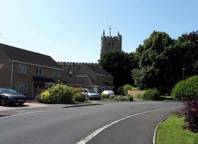
Stoke-sub-Hamdon
Stoke-sub-Hamdon (or Stoke sub Hamdon), also known as Stoke under Ham, is a large village and civil parish in the South Somerset district of Somerset,...

Stoke sub Hamdon Priory
Stoke sub Hamdon Priory is a complex of buildings and ruins which initially formed a 14th-century college for the chantry chapel of St Nicholas, and later...

Ham Hill Hillfort
Ham Hill Hillfort is an Iron Age hillfort located on Ham Hill, Somerset, England. It was also occupied during the mesolithic and neolithic periods and...
Norton-sub-Hamdon
Norton-sub-Hamdon is a village and civil parish in the South Somerset district of the English county of Somerset, situated ten miles west of Yeovil. The...

Ham Hill, Somerset
Ham Hill is a geological Site of Special Scientific Interest (SSSI), Scheduled Ancient Monument, Iron Age hill fort, Roman site, Local Nature Reserve and...
Church of All Saints, Martock
The Church of All Saints in Martock, Somerset, England dates from the 13th century and has been designated as a Grade I listed building.The church was...
Nearby Amenities
Located within 500m of 50.954198,-2.7647806Have you been to Percombe Hill?
Leave your review of Percombe Hill below (or comments, questions and feedback).