Mount Sned

Hill, Mountain in Angus

Scotland

Mount Sned

Hill of Glansie trig pillar The triangulation pillar on Hill of Glansie, looking north-westwards.
Hill of Glansie trig pillar Credit: Scott Cormie

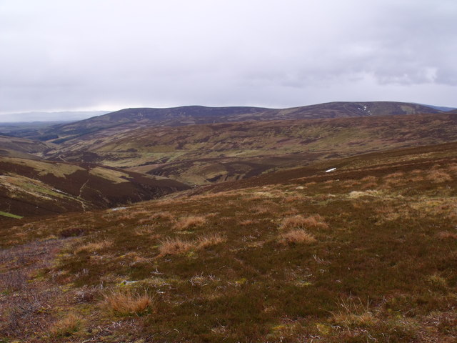
Mount Sned is a prominent hill located in the county of Angus, Scotland. Rising to an elevation of approximately 513 meters (1,683 feet), it is considered one of the notable landmarks in the area. Situated near the village of Edzell, Mount Sned offers breathtaking panoramic views of the surrounding countryside, making it a popular destination for hikers, nature enthusiasts, and photographers.

The hill is characterized by its distinctive conical shape and is predominantly covered in heather, grasses, and scattered patches of woodland. Its slopes are moderately steep, providing a challenging yet rewarding climb for those seeking outdoor adventure. As visitors ascend Mount Sned, they are treated to ever-expanding vistas of rolling hills, picturesque valleys, and the winding North Esk River.

At the summit of Mount Sned, there is a trig point, which serves as a marker for surveying and mapping purposes. From this vantage point, one can relish in the breathtaking views of the nearby Grampian Mountains, the North Sea coastline, and even glimpse the iconic peak of Mount Keen on a clear day.

Mount Sned is easily accessible by foot, with several footpaths leading to its summit. Local authorities have taken measures to ensure the preservation of the hill's natural beauty and biodiversity, making it an ideal location for flora and fauna observation. The area surrounding Mount Sned is also home to a variety of wildlife, including red deer, foxes, and a diverse range of bird species.

Overall, Mount Sned offers a rewarding outdoor experience, combining stunning natural scenery with opportunities for recreation and exploration.

If you have any feedback on the listing, please let us know in the comments section below.

Mount Sned Images

Images are sourced within 2km of 56.813984/-2.9057415 or Grid Reference NO4469. Thanks to Geograph Open Source API. All images are credited.

Hill of Glansie trig pillar The triangulation pillar on Hill of Glansie, looking north-westwards.
Hill of Glansie trig pillar
The triangulation pillar on Hill of Glansie, looking north-westwards.
Duthriss Hill Though named on the map as a hill, it is really a "bump" on a ridge leading to Dog hillock. Itself, a minor top on the Hill of Glansie.
Duthriss Hill
Though named on the map as a hill, it is really a "bump" on a ridge leading to Dog hillock. Itself, a minor top on the Hill of Glansie.
Track Down Ridge This is a view of part of the track system, on the hills above Glenogil, in Angus. This particular part is between Birse Shades and Bettywharran.
Track Down Ridge
This is a view of part of the track system, on the hills above Glenogil, in Angus. This particular part is between Birse Shades and Bettywharran.
Hill of Glansie Trig Point This is the summit of the Hill of Glansie. In the background (above trig point) is The Goet (Ben Tirran), in Glen Clova.
Hill of Glansie Trig Point
This is the summit of the Hill of Glansie. In the background (above trig point) is The Goet (Ben Tirran), in Glen Clova.
Slopes south of Mount Sned near Glen Lethnot Mapped tracks and actual tracks do not match up too exactly. The main metalled track from the south hairpins and ascends Hill of Garbet on the line of the path already marked. From this hairpin it also extends north but not as a metalled road and more to the west of the route mapped. Its line from the hairpin over to the Hill of Mondurran track is only a faint trace especially in poor visibility and crosses an area conserved and protected by electric fencing - stiles provided but you could miss these easily in poor weather.
Slopes south of Mount Sned near Glen Lethnot
Mapped tracks and actual tracks do not match up too exactly. The main metalled track from the south hairpins and ascends Hill of Garbet on the line of the path already marked. From this hairpin it also extends north but not as a metalled road and more to the west of the route mapped. Its line from the hairpin over to the Hill of Mondurran track is only a faint trace especially in poor visibility and crosses an area conserved and protected by electric fencing - stiles provided but you could miss these easily in poor weather.
Hairpin on track approaching from the south along west flank of Hill of Garbet near Glen Lethnot  Metalled road turns to left of photo and ascends north ridge of Hill of Garbet. Continuing towards camera is the line marked as a track on the map but falling somewhat short of this in reality.
Hairpin on track approaching from the south along west flank of Hill of Garbet near Glen Lethnot
Metalled road turns to left of photo and ascends north ridge of Hill of Garbet. Continuing towards camera is the line marked as a track on the map but falling somewhat short of this in reality.
Jacuzzi for pampered grouse by Hill of Garbet
Broad ridge south of Mount Sned near Glen Lethnot
Water course feeding Noran Water in Glen Ogil
Freshly burnt heather south of Mount Sned A grouse management measure to re-juvenate growth i.e. food. In staggered order over several seasons this gives a variety of heathers for food, shelter and protection.
Freshly burnt heather south of Mount Sned
A grouse management measure to re-juvenate growth i.e. food. In staggered order over several seasons this gives a variety of heathers for food, shelter and protection.
Broad ridges west of Hill of Garbet near Glen Lethnot
Fresh heather growth amongst the whitened stems of previous burning south of Mount Sned
Faint path marked as track on mapping to the north-west of Hill of Garbet This line skirts the small rise between Garbet and Sned rather than surmounts it as shown on the map.
Faint path marked as track on mapping to the north-west of Hill of Garbet
This line skirts the small rise between Garbet and Sned rather than surmounts it as shown on the map.
Grouse pampering equipment near Hill of Garbet above Glen Lethnot
 South-east slopes of Hill of Mondurran near Glen Lethnot
South-east slopes of Hill of Mondurran near Glen Lethnot
Wetland at head of Burn of Calletar near Glen Lethnot
Boggy, peaty sump in wetland feeding Burn of Calletar above Glen Lethnot
Grassy slopes on the north side of Hill of Garbet near Glen Lethnot
Show me another place!

Mount Sned is located at Grid Ref: NO4469 (Lat: 56.813984, Lng: -2.9057415)

Unitary Authority: Angus

Police Authority: Tayside

What 3 Words

///fanfare.daredevil.trembles. Near Kirriemuir, Angus

Nearby Locations

Mount Sned

Related Wikis

Angus (UK Parliament constituency)

Angus is a county constituency of the House of Commons of the Parliament of the United Kingdom (at Westminster). It elects one Member of Parliament (MP...

Five Glens of Angus

The Five Glens of Angus are the five Highland glens located in the western portion of the Angus region of Scotland. The five glens from westernmost to...

Auchnacree

Auchnacree is an estate in Angus, Scotland, five miles north of Forfar.In 1921 the estate overseer, Mr Frank Rae, discovered what is now called the Auchnacree...

Ben Tirran

Ben Tirran (896 m) is a mountain in the Grampian Mountains of Scotland. It lies in the vast Mounth area of the eastern Highlands in Angus, on the northern...

Nearby Amenities

Located within 500m of 56.813984,-2.9057415
Mount Sned
Ele: 618
Natural: peak
Lat/Long: 56.8137088/-2.9057937
The data included in this document is from www.openstreetmap.org. The data is made available under ODbL.

Have you been to Mount Sned?

Leave your review of Mount Sned below (or comments, questions and feedback).