High Street
Hill, Mountain in Westmorland Eden
England
High Street

High Street is a prominent hill and mountain located in the county of Westmorland, England. Situated in the Lake District National Park, it forms part of the Eastern Fells, an area renowned for its picturesque landscape and outdoor activities.
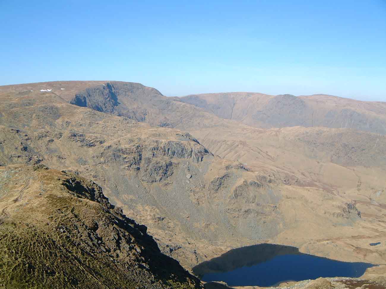
Rising to an elevation of 828 meters (2,717 feet), High Street boasts an impressive summit with breathtaking panoramic views of the surrounding countryside. The name "High Street" derives from the Roman road that once crossed the summit, connecting the forts at Brougham and Ambleside. This historic track is still visible in parts along the mountain's ridge.
High Street is a popular destination for hikers and nature enthusiasts, offering a variety of routes to suit different abilities. The most common starting point is the picturesque town of Troutbeck, where walkers can follow well-marked paths through beautiful valleys and up to the mountain's summit. Along the way, visitors can expect to encounter stunning alpine flora, cascading waterfalls, and charming stone walls that dot the landscape.
The summit of High Street provides an excellent vantage point to admire the neighboring peaks, including Helvellyn, Fairfield, and the Pennines. On clear days, it is even possible to catch a glimpse of the Irish Sea. The mountain's exposed nature means that weather conditions can change rapidly, so proper equipment and caution are advisable.
In addition to its natural beauty, High Street holds historical significance. The area is scattered with remnants of ancient settlements, including several cairns and stone circles, providing a glimpse into the region's past.
Overall, High Street in Westmorland offers a captivating blend of natural beauty, historical intrigue, and challenging hiking opportunities, making it a must-visit destination for outdoor enthusiasts and those seeking a connection with the region's rich heritage.
If you have any feedback on the listing, please let us know in the comments section below.
High Street Images
Images are sourced within 2km of 54.491668/-2.8648728 or Grid Reference NY4411. Thanks to Geograph Open Source API. All images are credited.


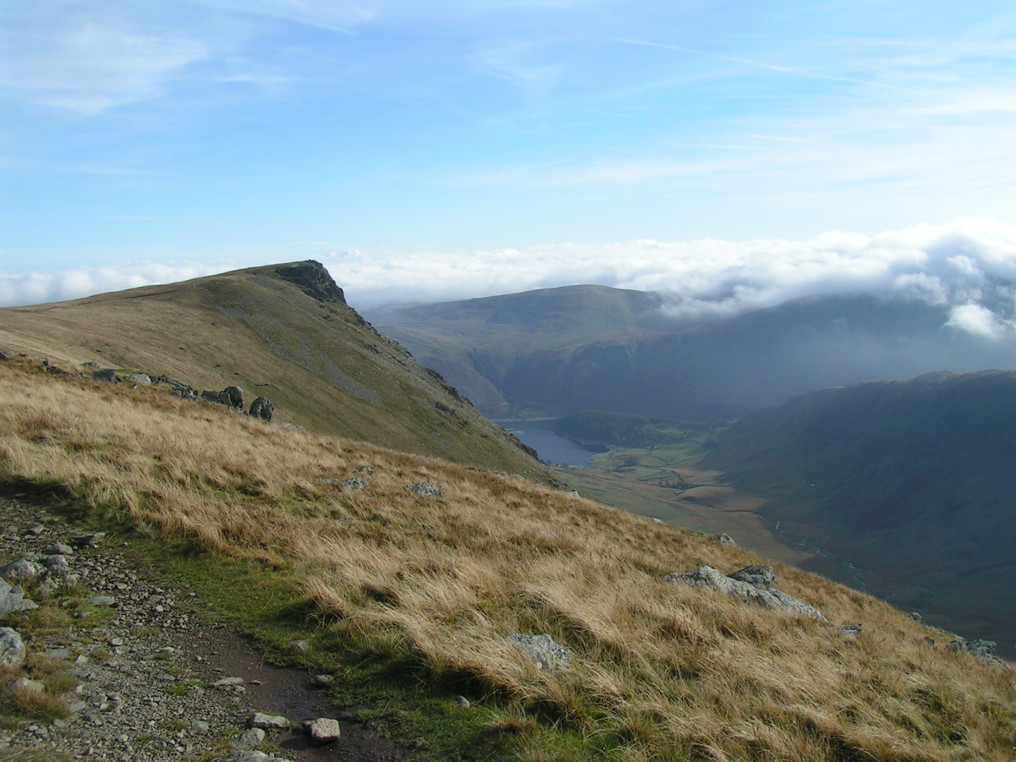
![High Streetâs Roman Road Or is it?
The first reference to a Roman Road over the 828m high fell High Street appeared in a book published in 1814 by John Britton and Edward Wedlake Brayley: ‘The Beauties of England and Wales, Or, Delineations, Topographical, Historical, and Descriptive, of Each County’.
In spite of some Victorian excavations, when nothing conclusive was found, the general assumption was that the route connected the Roman forts at Brougham, near Penrith, and Ambleside, suggesting that a likely construction date sometime during the late 1st or early 2nd century A.D.
That assumption is still put forward in many tourist information literature including that of the Lake District National Park.
An archaeological survey in 2006 in advance of some footpath repairs concluded that the road surface “is not what might be described as typical for the Roman period, but it does have some similarities with other [upland] roads of Roman date”.
Lowland Roman Roads were built raised above the general ground level, surfaced with a camber and with ditches either side, to ensure good drainage. In contrast, parts of the route over High Street actually shows signs of being a hollow-way.
So basically no evidence has been found that a road over High Street was built by the Romans. There may well have been an existing prehistoric route which may have been used by the Romans. Maybe even repaired by them.
The photo shows the route of the “road” as it passes the narrow col of the Straits of Riggindale after traversing Rampsgill Head and before the final climb up to High Street.
For sources see my blog <span class="nowrap"><a title="http://www.fhithich.uk/?p=27510" rel="nofollow ugc noopener" href="http://www.fhithich.uk/?p=27510">Link</a><img style="margin-left:2px;" alt="External link" title="External link - shift click to open in new window" src="https://s1.geograph.org.uk/img/external.png" width="10" height="10"/></span>](https://s2.geograph.org.uk/geophotos/07/13/52/7135274_b2865cf0.jpg)


High Street is located at Grid Ref: NY4411 (Lat: 54.491668, Lng: -2.8648728)
Administrative County: Cumbria
District: Eden
Police Authority: Cumbria
What 3 Words
///saving.costumed.press. Near Ambleside, Cumbria
Nearby Locations
Related Wikis
High Street (Lake District)
High Street is a fell in the English Lake District. At 828 metres (2,717 ft), its summit is the highest point in the far eastern part of the national park...

Blea Water
Blea Water is a tarn or corrie lake which occupies a glacially excavated hollow immediately to the east of High Street in the Lake District, England. At...

Mardale Ill Bell
Mardale Ill Bell is a fell in the English Lake District, rising to the south west of Haweswater Reservoir. It stands on the watershed between Mardale and...
Thornthwaite Crag
Thornthwaite Crag is a fell in the English Lake District, standing to the west of Haweswater Reservoir. It is a focal point of the Far Eastern Fells, standing...

Hayeswater
Hayeswater is a small lake within the Lake District of Cumbria, England. The lake is situated about a mile (1.6 km) SE of the hamlet of Hartsop in the...

Gray Crag
Gray Crag is a fell in the Lake District in Cumbria, England. == Topography == The fell reaches a height of 699 metres (2,293 feet) at the northern end...
Kidsty Pike
Kidsty Pike is a fell in the English Lake District, standing to the west of Haweswater Reservoir. It is a subsidiary top of Rampsgill Head, but has long...

The Knott
The Knott is a fell in the English Lake District, standing above Hayeswater in the Far Eastern Fells. It is an outlier of Rampsgill Head, being the high...
Nearby Amenities
Located within 500m of 54.491668,-2.8648728Have you been to High Street?
Leave your review of High Street below (or comments, questions and feedback).