Braid Cairn

Hill, Mountain in Aberdeenshire

Scotland

Braid Cairn

Trig point and summit cairn on Mount Keen
Trig point and summit cairn on Mount Keen Credit: Steven Brown

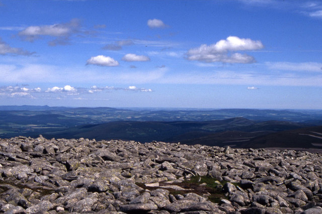
Braid Cairn is a prominent hill located in Aberdeenshire, Scotland. Situated in the eastern part of the county, it is part of the larger Cairngorms range. Standing at an impressive height of approximately 1,620 feet (494 meters), Braid Cairn offers breathtaking panoramic views of the surrounding landscapes.

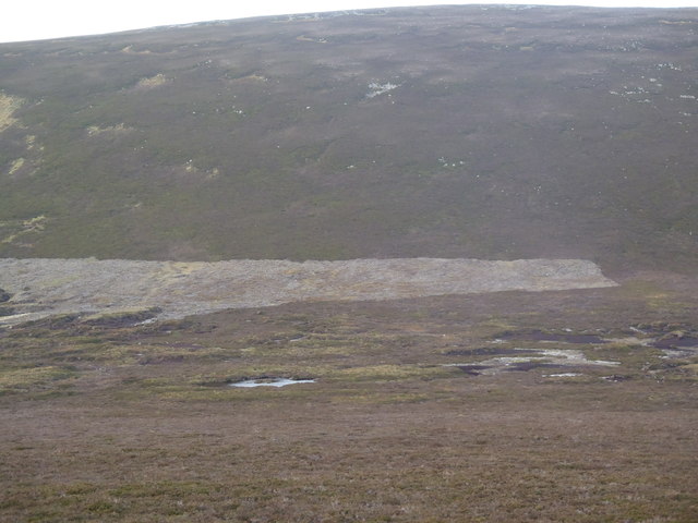
The hill is characterized by its distinctive conical shape, making it easily recognizable from afar. It is covered in heather and grass, creating a picturesque scene, especially during the summer months when the hillside bursts with vibrant colors. The terrain is moderately steep, making it accessible for hikers of various skill levels.

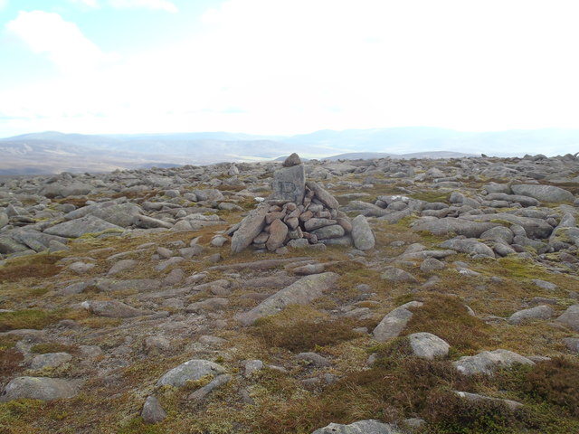
At the summit of Braid Cairn, there is a cairn or stone pile, which is believed to have been constructed by early settlers or travelers as a marker or memorial. This cairn adds historical significance to the site and serves as a point of interest for visitors.

The hill is a popular destination for outdoor enthusiasts, offering opportunities for hiking, hillwalking, and photography. The surrounding area is home to a diverse range of wildlife, including birds of prey, deer, and various species of plants and flowers.

To reach Braid Cairn, there are several well-marked trails and paths leading to the summit. The ascent can be challenging in some sections, but the rewarding views make it worthwhile. Visitors are advised to wear appropriate footwear and carry essential supplies, as the weather conditions can change quickly in this mountainous region.

Overall, Braid Cairn stands as a formidable and beautiful landmark in Aberdeenshire, attracting nature lovers and adventurers from near and far.

If you have any feedback on the listing, please let us know in the comments section below.

Braid Cairn Images

Images are sourced within 2km of 56.973142/-2.9457756 or Grid Reference NO4287. Thanks to Geograph Open Source API. All images are credited.

Trig point and summit cairn on Mount Keen
Trig point on the summit of Mount Keen
Mount Keen from the Lecht Road A large layby on the south side of the Lecht enjoys a fine view south-east. The glen in the foreground is that of the prosaically named Milltown Burn, and in the far distance, on the skyline, is Mount Keen.
Mount Keen from the Lecht Road
A large layby on the south side of the Lecht enjoys a fine view south-east. The glen in the foreground is that of the prosaically named Milltown Burn, and in the far distance, on the skyline, is Mount Keen.
High on Mount Keen Looking towards Glentanar down the badly eroded and braided path.
High on Mount Keen
Looking towards Glentanar down the badly eroded and braided path.
Summit of Mount Keen The 939m summit of the easternmost Munro.
Summit of Mount Keen
The 939m summit of the easternmost Munro.
The summit of Mount Keen Triangulation pillar on the top of Mount Keen looking northwards.
The summit of Mount Keen
Triangulation pillar on the top of Mount Keen looking northwards.
Summit, Mount Keen Granite boulders just north of the trig point.  Morven in the background.
Summit, Mount Keen
Granite boulders just north of the trig point. Morven in the background.
On Mount Keen Stony ground near the summit.  View towards the White Mounth and Lochnagar.
On Mount Keen
Stony ground near the summit. View towards the White Mounth and Lochnagar.
Over 900 metres Passing the 900 metre mark on the ascent of Mount Keen.
Over 900 metres
Passing the 900 metre mark on the ascent of Mount Keen.
The summit of Mount Keen Seeking some shelter north of the summit of Mount Keen, taking in a view to the south-west.
The summit of Mount Keen
Seeking some shelter north of the summit of Mount Keen, taking in a view to the south-west.
Approaching the summit of Mount Keen A view to the west of the summit path taking in the boulder-strewn flank of the mountain and the distant Lochnagar.
Approaching the summit of Mount Keen
A view to the west of the summit path taking in the boulder-strewn flank of the mountain and the distant Lochnagar.
The northwestern slopes of Mount Keen
Stony summit of Braid Cairn Mount Keen is the nearest summit on the left, whilst Lochnagar is just visible behind.
Stony summit of Braid Cairn
Mount Keen is the nearest summit on the left, whilst Lochnagar is just visible behind.
Stony summit of Braid Cairn The small pointed summit on the left, far horizon is Mither Tap near Inverurie.
Stony summit of Braid Cairn
The small pointed summit on the left, far horizon is Mither Tap near Inverurie.
Ski touring near Braid Cairn, Glen Esk Reaching larger snowfields by the Easter Burn.
Ski touring near Braid Cairn, Glen Esk
Reaching larger snowfields by the Easter Burn.
Ski touring on Braid Cairn, Glen Esk Gaining height on the south side of Braid Cairn.
Ski touring on Braid Cairn, Glen Esk
Gaining height on the south side of Braid Cairn.
Across the watershed between Braid Cairn and Naked Hill
Cairn near summit of Braid Cairn Note the 'B' inscribed into the centre stone.  Similarly marked stones can be found along the boundary line from Hill of Gairney to the Braid Cairn Plateau.
Cairn near summit of Braid Cairn
Note the 'B' inscribed into the centre stone. Similarly marked stones can be found along the boundary line from Hill of Gairney to the Braid Cairn Plateau.
Show me another place!

Braid Cairn is located at Grid Ref: NO4287 (Lat: 56.973142, Lng: -2.9457756)

Unitary Authority: Aberdeenshire

Police Authority: North East

What 3 Words

///blast.supplied.dockers. Near Ballater, Aberdeenshire

Nearby Locations

Braid Cairn

Related Wikis

Mount Keen

Mount Keen (Scottish Gaelic: Monadh Caoin) is a 939-metre-high (3,081 ft) mountain in Scotland and the most easterly Munro. It can be accessed from several...

Glen Mark

Glen Mark is a glen in northern Angus, eastern Scotland, through which the Water of Mark flows. Near the mouth of the glen, at Auchronie, the Water of...

Invermark Lodge

Invermark Lodge is a hunting lodge which was built near Invermark Castle in 1852 for John Ramsay, 13th Earl of Dalhousie. It is now a listed building...

Invermark Castle

Invermark Castle is an oblong tower house dating from the 16th century, at the east of Loch Lee, Angus, Scotland. It is near the head of Glen Esk. ��2...

Kincardine and Deeside

Kincardine and Deeside was formerly (1975–96) a local government district in the Grampian Region of Scotland. In 1996 it was included in the Aberdeenshire...

Falls of Unich

Falls of Unich is a waterfall of Scotland. == See also == Waterfalls of Scotland == References == Media related to Falls of Unich at Wikimedia Commons

Loch Lee

National grid reference NO431800 Loch Lee is a loch in Angus, Scotland south of the Grampian Mountains that is fed by the Water of Lee and the Water of...

Falls of Damff

Falls of Damff is a waterfall in Cairngorms National Park in Scotland. == See also == Waterfalls of Scotland == References ==

Nearby Amenities

Located within 500m of 56.973142,-2.9457756
Braid Cairn
Ele: 886
Natural: peak
Lat/Long: 56.9737814/-2.9446733
The data included in this document is from www.openstreetmap.org. The data is made available under ODbL.

Have you been to Braid Cairn?

Leave your review of Braid Cairn below (or comments, questions and feedback).