Hill of Snowy Slack

Hill, Mountain in Aberdeenshire

Scotland

Hill of Snowy Slack

Kebbuck Knowe Summit Kebbuck Knowe 672m (Subsimm)
Taken at the summit looking back down the fence line.
Kebbuck Knowe Summit Credit: Ralph Greig

Hill of Snowy Slack is a prominent hill located in Aberdeenshire, Scotland. Situated in the picturesque region of the Cairngorms National Park, it is part of the eastern Grampian Mountains. The hill stands at an impressive elevation of approximately 1,200 meters (3,937 feet), making it a popular destination for hikers, mountaineers, and nature enthusiasts.

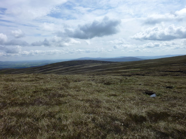
Hill of Snowy Slack is characterized by its rugged terrain and stunning panoramic views. Its slopes are covered in a mixture of heather, grass, and rocky outcrops, providing a diverse and picturesque landscape. The hill's peak offers breathtaking vistas of the surrounding countryside, including the nearby villages, farmland, and the River Dee flowing through the valley.

The area surrounding the hill is rich in wildlife, with various species of birds, mammals, and plants calling it home. Hikers may come across mountain hares, red deer, and even the elusive golden eagle during their ascent. The hill is also known for its diverse flora, including wildflowers such as heather, bilberry, and saxifrage.

Hill of Snowy Slack is a challenging climb, attracting experienced hikers and climbers seeking an adventure. Its steep slopes and unpredictable weather conditions require proper equipment and caution. However, the effort is rewarded with stunning views and a sense of accomplishment upon reaching the summit.

Overall, Hill of Snowy Slack offers a unique and rewarding outdoor experience for those looking to explore the breathtaking beauty of Aberdeenshire's mountainous landscape.

If you have any feedback on the listing, please let us know in the comments section below.

Hill of Snowy Slack Images

Images are sourced within 2km of 57.277193/-2.9748065 or Grid Reference NJ4121. Thanks to Geograph Open Source API. All images are credited.

Kebbuck Knowe Summit Kebbuck Knowe 672m (Subsimm)
Taken at the summit looking back down the fence line.
Kebbuck Knowe Summit
Kebbuck Knowe 672m (Subsimm) Taken at the summit looking back down the fence line.
Looking over the moor towards the Burn of Cross
This tiny burn is carving out a valley in the boulder clay
Burn draining the moor to the west of Mount Meddin The erosion is revealing the rocks in the boulder clay
Burn draining the moor to the west of Mount Meddin
The erosion is revealing the rocks in the boulder clay
Looking between Mount Meddin and Kebbuck Knowe
Moorland and the valley of the Burn of Cookies-shiel Beyond the burn are the lower slopes of Kebbuck Knowe, an outlier of The Buck
Moorland and the valley of the Burn of Cookies-shiel
Beyond the burn are the lower slopes of Kebbuck Knowe, an outlier of The Buck
Moorland and the valleys of the Burn of Cookies-shiel and the Burn of  Blaidsaughs In the background, The Buck of the Cabrach
Moorland and the valleys of the Burn of Cookies-shiel and the Burn of Blaidsaughs
In the background, The Buck of the Cabrach
Moorland and the valley of the Burn of Cookies-shiel
Kebbuck Knowe The grassy moorland of Kebbuck Knowe descends to a col then rises beyond to the Graham of The Buck.
Kebbuck Knowe
The grassy moorland of Kebbuck Knowe descends to a col then rises beyond to the Graham of The Buck.
Kebbuck Knowe Col Looking east from the soggy col between "The Buck" and Kebbuck Knowe.
Kebbuck Knowe Col
Looking east from the soggy col between "The Buck" and Kebbuck Knowe.
Looking S from The Buck The trig point on The Buck with Kebbuck Knowe behind.
Looking S from The Buck
The trig point on The Buck with Kebbuck Knowe behind.
Moorland Track This is one of the very few lengths of track in this square. One of its ruts has also become a burn, draining the melting snowdrift above.
Moorland Track
This is one of the very few lengths of track in this square. One of its ruts has also become a burn, draining the melting snowdrift above.
The Buck sunrise. Early morning sunrise from The Buck's summit.
The Buck sunrise.
Early morning sunrise from The Buck's summit.
Track on Green Brow Track built for grouse shooting across the ridge of Green Brow. The local landmark, The Buck (721m,) can just be seen in the distance.
Track on Green Brow
Track built for grouse shooting across the ridge of Green Brow. The local landmark, The Buck (721m,) can just be seen in the distance.
Heather moorland Grouse shooting moorland
Heather moorland
Grouse shooting moorland
Summit of Kebbuck Knowe View from the summit of Kebbuck Knowe (672m), looking across to the summit of The Buck (721m), a local landmark as it's a steep pointed hill from most other angles.
Summit of Kebbuck Knowe
View from the summit of Kebbuck Knowe (672m), looking across to the summit of The Buck (721m), a local landmark as it's a steep pointed hill from most other angles.
Heather Moor The slope here is convex, dropping more steeply to the Clashmaare Burn in the glen below. On the skyline is the ridge which links Clova Hill and the Hill of John's Cairn. The grey smudge in the sky at extreme left is the smoke from burning heather for grouse, which results in bare patches like the one on the right, and the parti-coloured appearance of the hillsides. On land over 450 metres above sea level, muirburning may take place until 30 April, while at lower levels it may not continue after 15 April.
Heather Moor
The slope here is convex, dropping more steeply to the Clashmaare Burn in the glen below. On the skyline is the ridge which links Clova Hill and the Hill of John's Cairn. The grey smudge in the sky at extreme left is the smoke from burning heather for grouse, which results in bare patches like the one on the right, and the parti-coloured appearance of the hillsides. On land over 450 metres above sea level, muirburning may take place until 30 April, while at lower levels it may not continue after 15 April.
Clashnarae Burn The view down from the summit to the Clashnarae Burn. The topography is emphasized by the contrasting swathes of snow and heather meeting in the bottom of the glen. I do not know if the heap of stones has any significance; probably not, as there is no indication on the map of any ancient sites  up here.
Clashnarae Burn
The view down from the summit to the Clashnarae Burn. The topography is emphasized by the contrasting swathes of snow and heather meeting in the bottom of the glen. I do not know if the heap of stones has any significance; probably not, as there is no indication on the map of any ancient sites up here.
Show me another place!

Hill of Snowy Slack is located at Grid Ref: NJ4121 (Lat: 57.277193, Lng: -2.9748065)

Unitary Authority: Aberdeenshire

Police Authority: North East

What 3 Words

///vision.wager.mainly. Near Alford, Aberdeenshire

Nearby Locations

Hill of Snowy Slack

Related Wikis

Clova Monastery

Clova Monastery (also called Cloveth) was a medieval Culdee monastery in Kildrummy, Aberdeenshire, Scotland. == Founding == Clova was founded in the late...

Clashindarroch Forest

Clashindarroch Forest is possibly the largest forest in Aberdeenshire, situated to the south-west of the market town of Huntly. Managed by Forest Enterprise...

Grampian

Grampian (Scottish Gaelic: Roinn a' Mhonaidh) was one of nine former local government regions of Scotland created in 1975 by the Local Government (Scotland...

Lumsden, Aberdeenshire

Lumsden is an inland village in Aberdeenshire, Scotland on the A97 road. == Location == It crowns a rising-ground 227 m (745 ft) above sea level amid a...

Nearby Amenities

Located within 500m of 57.277193,-2.9748065
Hill of Snowy Slack
Ele: 596
Natural: peak
Lat/Long: 57.2773305/-2.9751535
Generator Method: wind_turbine
Generator Output Electricity: yes
Generator Source: wind
Generator Type: horizontal_axis
Power: generator
Lat/Long: 57.2745943/-2.9713941
The data included in this document is from www.openstreetmap.org. The data is made available under ODbL.

Have you been to Hill of Snowy Slack?

Leave your review of Hill of Snowy Slack below (or comments, questions and feedback).