The Dod

Hill, Mountain in Selkirkshire

Scotland

The Dod

Hungryhill Moss Last time I visited, a lot of images including one I needed to complete NT42 failed, I did not get anything fit to submit due to the gloom.  Much better on this bright afternoon.
Hungryhill Moss Credit: Richard Webb

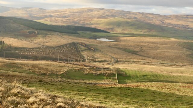
The Dod is a prominent hill located in the Selkirkshire region of Scotland. Standing at an impressive height of 710 meters (2,329 feet), it is a notable landmark in the area and offers breathtaking views of the surrounding countryside.

Situated near the town of Selkirk, The Dod is part of the Southern Uplands range and is a popular destination for hikers and outdoor enthusiasts. Its distinctive shape and rocky terrain make it a challenging but rewarding climb. The hill is characterized by its steep slopes and craggy peaks, providing an exhilarating ascent for those seeking an adventure.

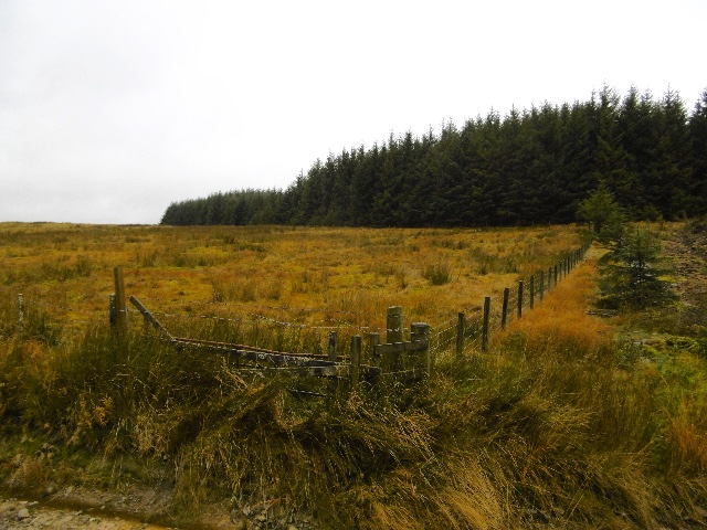
The Dod is known for its diverse wildlife and natural beauty. The hill is home to a variety of flora and fauna, including heather-covered moorland, native trees, and a range of bird species. The area also boasts an abundance of wildflowers and rare plant species, adding to its ecological significance.

The summit of The Dod offers panoramic views of the surrounding landscape, with rolling hills and valleys stretching as far as the eye can see. On a clear day, it is possible to spot other notable landmarks, such as the Ettrick Valley and the neighboring Moffat Hills.

Whether it's for a challenging hike, wildlife spotting, or simply enjoying the stunning vistas, The Dod in Selkirkshire is a must-visit destination for nature lovers and outdoor enthusiasts alike.

If you have any feedback on the listing, please let us know in the comments section below.

The Dod Images

Images are sourced within 2km of 55.484716/-2.9355073 or Grid Reference NT4021. Thanks to Geograph Open Source API. All images are credited.

Hungryhill Moss Last time I visited, a lot of images including one I needed to complete NT42 failed, I did not get anything fit to submit due to the gloom.  Much better on this bright afternoon.
Hungryhill Moss
Last time I visited, a lot of images including one I needed to complete NT42 failed, I did not get anything fit to submit due to the gloom. Much better on this bright afternoon.
Around the Langhope Burn Dismal moorland, even more dismal forestry and behind me a wind farm.
Around the Langhope Burn
Dismal moorland, even more dismal forestry and behind me a wind farm.
Wind turbines, Langhope Rig
Mast, Langhope Rig On the, current, edge of the wind farm.
Mast, Langhope Rig
On the, current, edge of the wind farm.
Caver's Hill summit The plantation had taken a battering in the recent storms (26/11/2021) but the summit area was relatively unscathed.
Caver's Hill summit
The plantation had taken a battering in the recent storms (26/11/2021) but the summit area was relatively unscathed.
Caver's Hill Near the summit which is in the wood. The woodland had suffered windthrow on 26th November 2021 but there was a safe, undamaged route to the top.
Caver's Hill
Near the summit which is in the wood. The woodland had suffered windthrow on 26th November 2021 but there was a safe, undamaged route to the top.
Recent clearfell, Caver's Hill At the foot of Caver's Hill. I suspect they may have got them in in time. There was a lot of fresh windthrow in the area, as with many places after "Arwen", a big gale on 26th November 2021.
Recent clearfell, Caver's Hill
At the foot of Caver's Hill. I suspect they may have got them in in time. There was a lot of fresh windthrow in the area, as with many places after "Arwen", a big gale on 26th November 2021.
Sheepy singletrack Sheep path along the route of an old road heading for Ettrickbridge. It is a waymarked route and horse riding is actively encouraged.
Sheepy singletrack
Sheep path along the route of an old road heading for Ettrickbridge. It is a waymarked route and horse riding is actively encouraged.
Under Howford Hill Cannot find a name for the house. There are some very good old tracks here including waymarked routes for horse riding - ie no locked gates!
Under Howford Hill
Cannot find a name for the house. There are some very good old tracks here including waymarked routes for horse riding - ie no locked gates!
Gate on the track to Ettrickbridge A route contouring the south side of Helmburn Hill.
Gate on the track to Ettrickbridge
A route contouring the south side of Helmburn Hill.
Cavers Hill Conifer strip seen across the Ettrick Water from Witchie Knowe. The Langhope Rig wind farm is being constructed to the south.
Cavers Hill
Conifer strip seen across the Ettrick Water from Witchie Knowe. The Langhope Rig wind farm is being constructed to the south.
Above Ettrick Bridge A gate with a Buccleuch Country Rides waymark.
Above Ettrick Bridge
A gate with a Buccleuch Country Rides waymark.
New road, Hyndhope Forest An extension built to serve the wind farm, also useful to the foresters.
New road, Hyndhope Forest
An extension built to serve the wind farm, also useful to the foresters.
Easterhill Head A very rough field on the edge of Hyndhope Forest.  View from the wind farm road.
Easterhill Head
A very rough field on the edge of Hyndhope Forest. View from the wind farm road.
Winding track This track forms part of the Buccleuch County Ride. Taken on a fine December day.
Winding track
This track forms part of the Buccleuch County Ride. Taken on a fine December day.
Sheep field Four sheep stand in a frosted field on a December late afternoon. The small farm in the background is unnamed on the Explorer Map.
Sheep field
Four sheep stand in a frosted field on a December late afternoon. The small farm in the background is unnamed on the Explorer Map.
Sheep pasture The buildings in the background lie to the East of Helmburn Hill and are unnamed on the Explorer Map.
Sheep pasture
The buildings in the background lie to the East of Helmburn Hill and are unnamed on the Explorer Map.
Drainage ditch, Easterhill Head The rough grazing is also rather boggy, so an attempt has been made to drain the land.  Over the brow of the hill is a plantation.
Drainage ditch, Easterhill Head
The rough grazing is also rather boggy, so an attempt has been made to drain the land. Over the brow of the hill is a plantation.
Show me another place!

The Dod is located at Grid Ref: NT4021 (Lat: 55.484716, Lng: -2.9355073)

Unitary Authority: The Scottish Borders

Police Authority: The Lothians and Scottish Borders

What 3 Words

///justifies.tanks.number. Near Selkirk, Scottish Borders

Related Wikis

Ettrickbridge

Ettrickbridge (Scottish Gaelic: Drochaid Eadaraig) is a village situated in the Scottish Borders region of Scotland, 7 miles (11 km) from the nearby town...

Oakwood Roman Fort and Camp

Oakwood Roman Fort and Camp is a British archaeological site, a Roman fort and nearby Roman camp, about 3.5 miles (5.6 km) south-west of Selkirk in the...

Selkirkshire

Selkirkshire or the County of Selkirk (Scottish Gaelic: Siorrachd Shalcraig) is a historic county and registration county of Scotland. It borders Peeblesshire...

Aikwood Tower

Aikwood Tower (formerly known as Oakwood Tower) is a 16th-century tower house in the Scottish Borders area of Scotland, 4 miles (6 kilometres) southwest...

Have you been to The Dod?

Leave your review of The Dod below (or comments, questions and feedback).