Nether Hill

Hill, Mountain in Selkirkshire

Scotland

Nether Hill

Hillside above the Caddon Water Down the slope to the left is the Oak Burn, a feeder stream for the Caddon Water. The summit R of centre is Tittin Law.
Hillside above the Caddon Water Credit: Jim Barton

Nether Hill is a prominent hill located in Selkirkshire, Scotland. Situated near the town of Selkirk, it is part of the Southern Uplands, a range of hills that form the border between Scotland and England. Nether Hill stands at an elevation of approximately 405 meters (1,329 feet) and offers stunning panoramic views of the surrounding countryside.

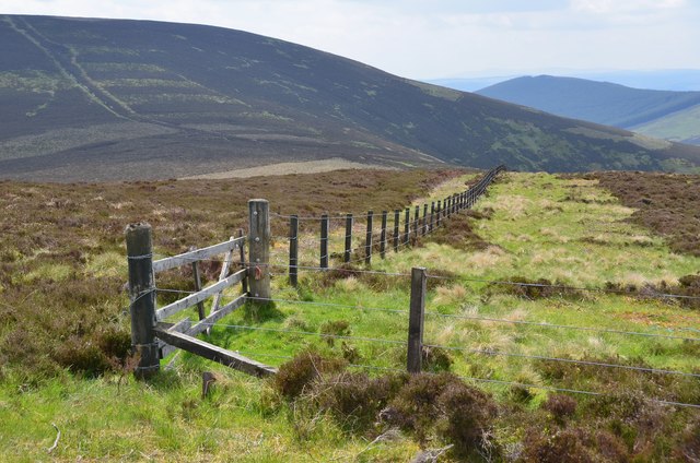
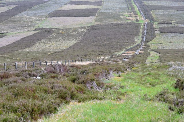
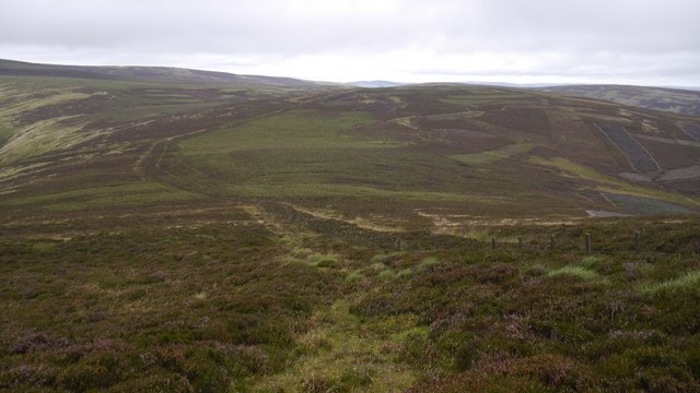
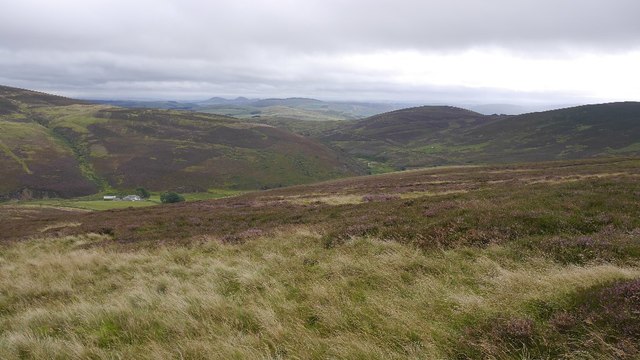
The hill is characterized by its gentle slopes and rolling terrain, making it a popular destination for outdoor enthusiasts. It is a favored spot for hikers, walkers, and nature lovers who wish to explore the beautiful Scottish landscape. The area surrounding Nether Hill is rich in flora and fauna, with several species of birds, wildflowers, and small mammals inhabiting its slopes.

Visitors to Nether Hill can enjoy a variety of activities, including hiking trails that lead to its summit. The ascent is rewarding, as it provides breathtaking vistas of the Tweed Valley, the Ettrick Hills, and the Cheviot Hills. On clear days, it is even possible to see as far as the Northumberland coast.

Nether Hill is also of historical significance, with remnants of ancient settlements and forts scattered across its slopes. These archaeological features provide valuable insights into the region's past, attracting history enthusiasts and researchers.

Overall, Nether Hill offers a stunning natural environment, recreational opportunities, and a glimpse into the area's rich heritage. Whether for leisurely walks, outdoor adventures, or historical exploration, Nether Hill is a captivating destination for visitors of all ages.

If you have any feedback on the listing, please let us know in the comments section below.

Nether Hill Images

Images are sourced within 2km of 55.657348/-2.945168 or Grid Reference NT4040. Thanks to Geograph Open Source API. All images are credited.

Hillside above the Caddon Water Down the slope to the left is the Oak Burn, a feeder stream for the Caddon Water. The summit R of centre is Tittin Law.
Hillside above the Caddon Water
Down the slope to the left is the Oak Burn, a feeder stream for the Caddon Water. The summit R of centre is Tittin Law.
Southeast side of Seathope Law Archetypal grouse moor on this rounded hill between Gatehopeknowe Burn to the west and the Caddon Water drainage to the east.
Southeast side of Seathope Law
Archetypal grouse moor on this rounded hill between Gatehopeknowe Burn to the west and the Caddon Water drainage to the east.
Angle in the fence, Maiden Law Seathope Law (L) and Cairn Hill (R) are in view. It is interesting to compare with Chris Eilbeck's photo <a href="https://www.geograph.org.uk/photo/162283">NT3841 : Gate and fence, Maiden Law</a> taken in 2006. The fence has been repaired somewhat and there is a little more grass in the strip but overall, not much change in 10 years.
Angle in the fence, Maiden Law
Seathope Law (L) and Cairn Hill (R) are in view. It is interesting to compare with Chris Eilbeck's photo NT3841 : Gate and fence, Maiden Law taken in 2006. The fence has been repaired somewhat and there is a little more grass in the strip but overall, not much change in 10 years.
Summit area, Maiden Law 'Summit' seems to be an inappropriate term for the imperceptibly convex heather dome hereabouts. A view to Seathope Law, which has an equally flattened top.
Summit area, Maiden Law
'Summit' seems to be an inappropriate term for the imperceptibly convex heather dome hereabouts. A view to Seathope Law, which has an equally flattened top.
Col north of Seathope Law The slopes to the right lead up to Maiden Law.
Col north of Seathope Law
The slopes to the right lead up to Maiden Law.
Descent from Seathope Law Descending to the col towards Stony Knowe.
Descent from Seathope Law
Descending to the col towards Stony Knowe.
Oak Burn The birch, 13 years on from <a href="https://www.geograph.org.uk/photo/200161">NT3940 : Oak Burn</a>
Oak Burn
The birch, 13 years on from NT3940 : Oak Burn
Oak Burn and Maiden Law Sheep grazed moorland above the Caddon Water.
Oak Burn and Maiden Law
Sheep grazed moorland above the Caddon Water.
Down the Caddon Water Moorland around the upper Caddon Water.
Down the Caddon Water
Moorland around the upper Caddon Water.
Descent from Seathope Law An easy fun descent with the more gentle Maiden Law next on the ridge. There is a clear path, good news as the ground is rough away from it.
Descent from Seathope Law
An easy fun descent with the more gentle Maiden Law next on the ridge. There is a clear path, good news as the ground is rough away from it.
Fence, Maiden Law At the time of visit, the going was easier on the other side of the fence.
Fence, Maiden Law
At the time of visit, the going was easier on the other side of the fence.
Seathope Law North side of the hill viewed from Maiden Law.
Seathope Law
North side of the hill viewed from Maiden Law.
Above Seat Hope Moorland on Maiden Law with a broad ridge extending towards Windlestraw Law.
Above Seat Hope
Moorland on Maiden Law with a broad ridge extending towards Windlestraw Law.
Summit, Maiden Law A flat area covered by tussocks. Not easy going, but there is a good track nearby.
Summit, Maiden Law
A flat area covered by tussocks. Not easy going, but there is a good track nearby.
Moorland, Maiden Moor Seathope Law in the background. The going is rough, but there is a good grassy track crossing the moor here and descending to Caddonhead.
Moorland, Maiden Moor
Seathope Law in the background. The going is rough, but there is a good grassy track crossing the moor here and descending to Caddonhead.
Track, Maiden Law A good, easy quadbike track climbes up from Caddonhead. A fast descent on the bike.
Track, Maiden Law
A good, easy quadbike track climbes up from Caddonhead. A fast descent on the bike.
Caddonhead Last farm up the Caddon Water.
Caddonhead
Last farm up the Caddon Water.
Road to Scroof The road up the Caddon Water leaves Caddonhead.
Road to Scroof
The road up the Caddon Water leaves Caddonhead.
Show me another place!

Nether Hill is located at Grid Ref: NT4040 (Lat: 55.657348, Lng: -2.945168)

Unitary Authority: The Scottish Borders

Police Authority: The Lothians and Scottish Borders

What 3 Words

///loafing.chest.return. Near Innerleithen, Scottish Borders

Nearby Locations

Nether Hill

Related Wikis

Windlestraw Law

Windlestraw Law is a hill in the Moorfoot Hills range, part of the Southern Uplands of Scotland. It is the highest peak of the range, and lies north of...

Thornielee railway station

Thornielee railway station served the smallholding of Thornielee, Scottish Borders, Scotland from 1866 to 1950 on the Peebles Railway. == History == The...

Bowshank

Bowshank is a village in the Scottish Borders area of Scotland, close to the A7, beside the Gala Water. Nearby are Bow Castle Broch, as well as Buckholm...

Bowland railway station

Bowland railway station (Bowland Bridge between May 1849 and July 1862) was a railway station in the village of Bowland, near Galashiels, Scotland. Located...

Have you been to Nether Hill?

Leave your review of Nether Hill below (or comments, questions and feedback).