High Hartsop Dodd

Hill, Mountain in Westmorland Eden

England

High Hartsop Dodd

Kirkstone Pass
Kirkstone Pass Credit: Peter McDermott

High Hartsop Dodd is a prominent hill located in the Lake District National Park, in the county of Westmorland, England. Standing at a height of 519 meters (1,703 feet), it is a popular destination for hikers and outdoor enthusiasts.

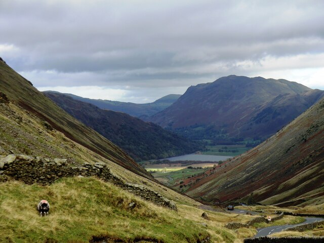
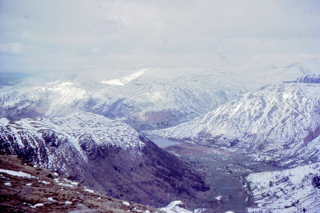
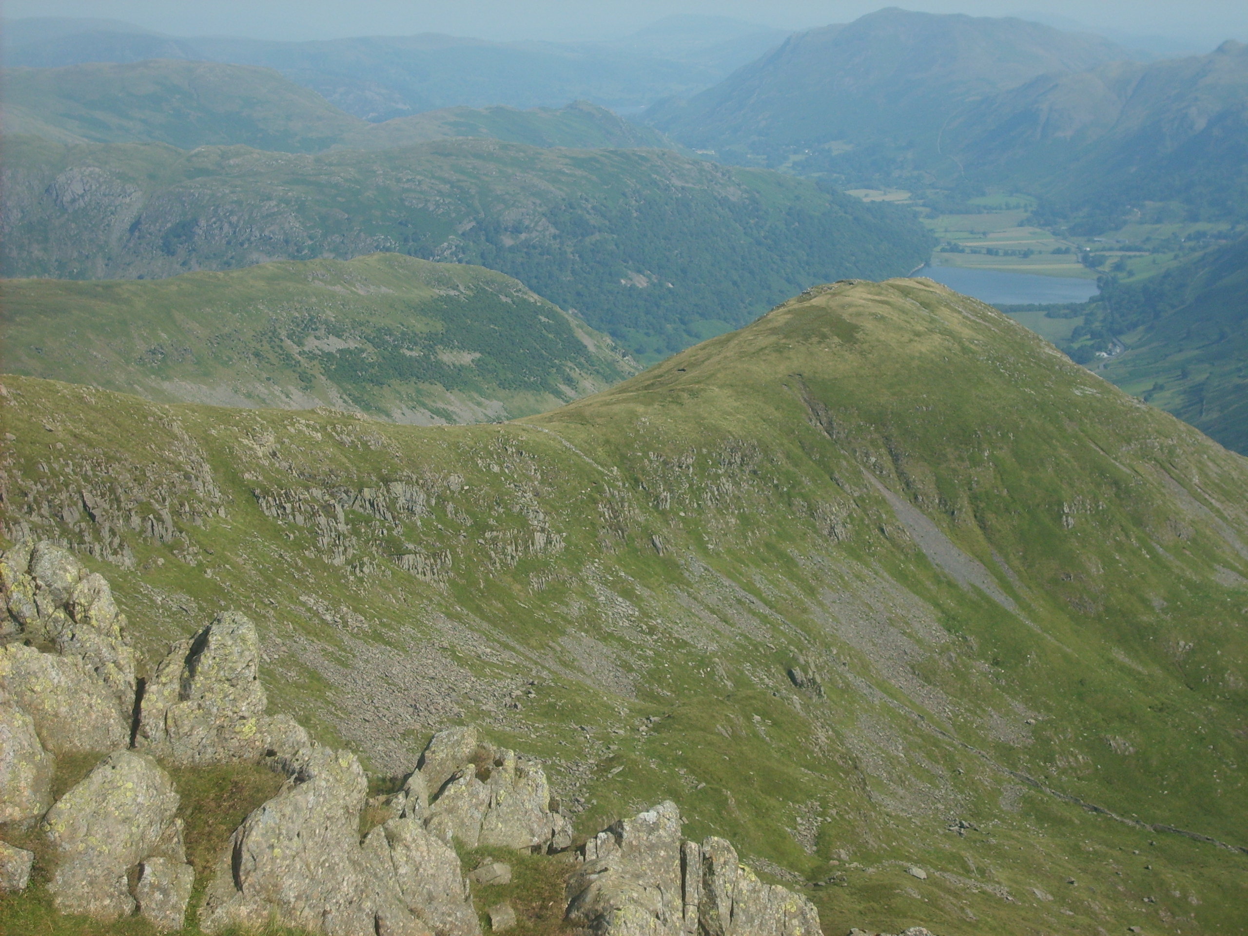
The hill is situated in the Eastern Fells region of the Lake District, near the picturesque village of Hartsop. It offers stunning panoramic views of the surrounding countryside, including the nearby valleys of Patterdale and Ullswater. On a clear day, visitors can also catch a glimpse of the towering peaks of Helvellyn and Fairfield.

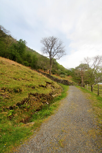
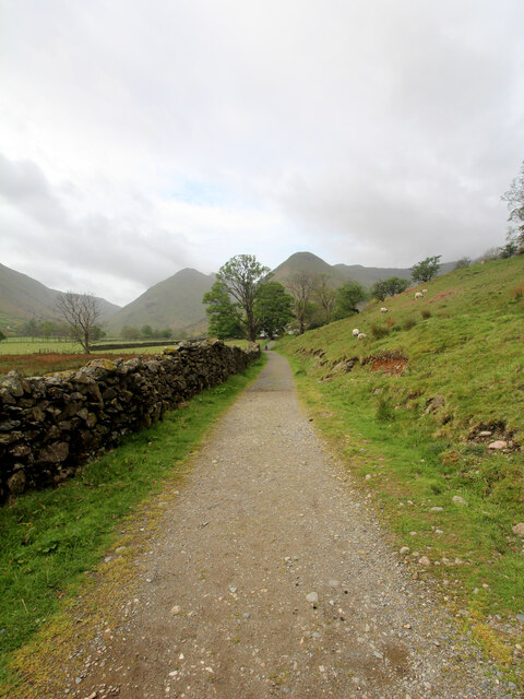
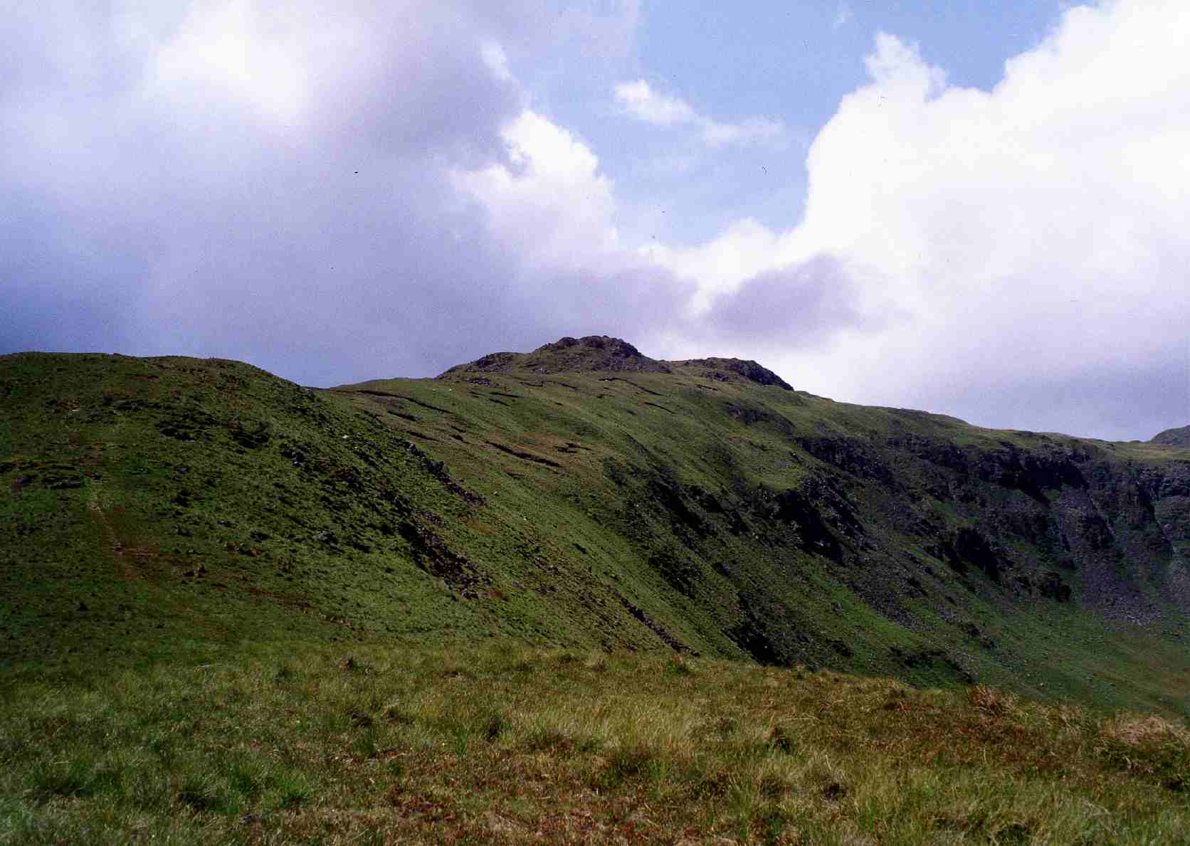
The ascent to High Hartsop Dodd is relatively gentle, making it suitable for walkers of all abilities. The route begins in Hartsop village and follows a well-defined path that winds its way up the hillside. Along the way, hikers pass through beautiful open countryside, with heather-clad moorland and rocky outcrops dotting the landscape.

Once at the summit, visitors are rewarded with breathtaking vistas of the surrounding Lakeland scenery. The views extend across the shimmering waters of Brotherswater and beyond, offering a true sense of tranquility and natural beauty.

High Hartsop Dodd is also a popular spot for birdwatchers, with various species of birds, including golden eagles and peregrine falcons, frequently spotted in the area.

Overall, High Hartsop Dodd is a delightful hill that showcases the rugged charm and scenic splendor of the Lake District. Whether you are a seasoned hiker or simply looking for a peaceful escape in nature, this hill is a must-visit destination.

If you have any feedback on the listing, please let us know in the comments section below.

High Hartsop Dodd Images

Images are sourced within 2km of 54.488492/-2.9376843 or Grid Reference NY3910. Thanks to Geograph Open Source API. All images are credited.

Kirkstone Pass
Kirkstone Pass
Kirkstone Pass, Cumbria Looking down Kirkstone Pass towards Brothers water
Kirkstone Pass, Cumbria
Looking down Kirkstone Pass towards Brothers water
Footpath from Cow Bridge The conceptualisation of a footpath being "to" or "from" a location depends on the direction of travel of the person doing the describing. Today we had started at Cow Bridge to ascend Fairfield via Dovedale, so this photo looking back qualifies as a "from" Cow Bridge. Equally, it passes Hartsop Hall before heading upwards and these could have been "to" if looking the other way (as in <a href="https://www.geograph.org.uk/photo/7174575">NY3912 : Footpath to Hartsop Hall</a>). By this point, the path is no longer going "past" Brothers Water, though the wall from the gateway does drop down to the shore of same, at its most southerly point.
Footpath from Cow Bridge
The conceptualisation of a footpath being "to" or "from" a location depends on the direction of travel of the person doing the describing. Today we had started at Cow Bridge to ascend Fairfield via Dovedale, so this photo looking back qualifies as a "from" Cow Bridge. Equally, it passes Hartsop Hall before heading upwards and these could have been "to" if looking the other way (as in NY3912 : Footpath to Hartsop Hall). By this point, the path is no longer going "past" Brothers Water, though the wall from the gateway does drop down to the shore of same, at its most southerly point.
Footpath to Hartsop Hall The conceptualisation of a footpath being "to" or "from" a location depends on the direction of travel of the person doing the describing. Today we had started at Cow Bridge to ascend Fairfield via Dovedale, so this photo looking the way we are going counts as a "to". It's destination could equally well have been given as Dovedale, or Dove Crag (seen in the distance), or any of several places off that path (Black Crag was once such, back in my climbing days).
Footpath to Hartsop Hall
The conceptualisation of a footpath being "to" or "from" a location depends on the direction of travel of the person doing the describing. Today we had started at Cow Bridge to ascend Fairfield via Dovedale, so this photo looking the way we are going counts as a "to". It's destination could equally well have been given as Dovedale, or Dove Crag (seen in the distance), or any of several places off that path (Black Crag was once such, back in my climbing days).
Field barn at the foot of Dovedale The public footpath from Cow Bridge, past Hartsop Hall and on its way to the tops of the Fairfield massif breaks into CROW Access Land just before passing this field barn. The path has, by this time, downgraded from the hard surfaced highway that started out past Brothers Water and has become a more traditional muddy trod, inhabited (and polluted) by cows, so at least one can coem home with boots that look as though they've been somewhere.
Field barn at the foot of Dovedale
The public footpath from Cow Bridge, past Hartsop Hall and on its way to the tops of the Fairfield massif breaks into CROW Access Land just before passing this field barn. The path has, by this time, downgraded from the hard surfaced highway that started out past Brothers Water and has become a more traditional muddy trod, inhabited (and polluted) by cows, so at least one can coem home with boots that look as though they've been somewhere.
Footpath to Dove Crag Despite recent wet weather, the public footpath up Dovedale, which stays close to the beck, manages to stay pretty dry underfoot. There's a more heavily used path (not a right of way) higher up to our right, which seems a better bet if the ground here is even wetter. There's also a fainter path on the left of the photo which avoids crossing the beck at the point that the right of way changes sides, but it appears to rather fizzle out higher up, as though its users thought better of it and decided to join the main thoroughfare.
Footpath to Dove Crag
Despite recent wet weather, the public footpath up Dovedale, which stays close to the beck, manages to stay pretty dry underfoot. There's a more heavily used path (not a right of way) higher up to our right, which seems a better bet if the ground here is even wetter. There's also a fainter path on the left of the photo which avoids crossing the beck at the point that the right of way changes sides, but it appears to rather fizzle out higher up, as though its users thought better of it and decided to join the main thoroughfare.
Split boulder by path to Dove Crag When does a split boulder become two boulders ? The ones here have clearly once been united in single boulderhood but are now quite well separated as the more northerly half has foundered into soft soil. The public right of way passes quite close (I'd barely stepped off the path to take this shot) on its way to the shallow col between Dove Crag and Hart Crag, on the normal troute of the Fairfield horseshoe. Dove Crag forms an imposing buttress as seen from Dovedale, and the increasingly steep route turns it to the right, passing a barely discernible trod to the Priests' Hole which is now more likely to provide shelter to climbers avoiding the rain than to one sort of religious practitioner avoiding persecution by the others.
Split boulder by path to Dove Crag
When does a split boulder become two boulders ? The ones here have clearly once been united in single boulderhood but are now quite well separated as the more northerly half has foundered into soft soil. The public right of way passes quite close (I'd barely stepped off the path to take this shot) on its way to the shallow col between Dove Crag and Hart Crag, on the normal troute of the Fairfield horseshoe. Dove Crag forms an imposing buttress as seen from Dovedale, and the increasingly steep route turns it to the right, passing a barely discernible trod to the Priests' Hole which is now more likely to provide shelter to climbers avoiding the rain than to one sort of religious practitioner avoiding persecution by the others.
Footpath to Dove Crag The right of way ascends from Brothers Water up Dovedale to the shallow col between Dove Crag (on the left) and Hart Crag, on the normal troute of the Fairfield horseshoe. Dove Crag forms an imposing buttress as seen from Dovedale, and the increasingly steep route turns it to the right, passing a barely discernible trod to the Priests' Hole which is now more likely to provide shelter to climbers avoiding the rain than to one sort of religious practitioner avoiding persecution by the others.
Footpath to Dove Crag
The right of way ascends from Brothers Water up Dovedale to the shallow col between Dove Crag (on the left) and Hart Crag, on the normal troute of the Fairfield horseshoe. Dove Crag forms an imposing buttress as seen from Dovedale, and the increasingly steep route turns it to the right, passing a barely discernible trod to the Priests' Hole which is now more likely to provide shelter to climbers avoiding the rain than to one sort of religious practitioner avoiding persecution by the others.
Summit area of Dove Crag
Dovedale from Dove Crag Dovedale and Brothers Water in early April snow cover 1966.
Dovedale from Dove Crag
Dovedale and Brothers Water in early April snow cover 1966.
Waterfalls above Smithy Brow
The Kirkstone pass road. One of the districts best sections of road.
The Kirkstone pass road.
One of the districts best sections of road.
Mine spoil heap beside Kirkstone Beck Kirkstone Beck drains the valley through which rises the Kirkstone Pass road, the A592.
There's little spoil at the mine site and so it's suspected that the working was simply a trial, one where an exploratory level was driven into the hill slope in the hope of discovering something worth mining, and nothing was.
Mine spoil heap beside Kirkstone Beck
Kirkstone Beck drains the valley through which rises the Kirkstone Pass road, the A592. There's little spoil at the mine site and so it's suspected that the working was simply a trial, one where an exploratory level was driven into the hill slope in the hope of discovering something worth mining, and nothing was.
Waterfalls in The Kirkstone Pass
The Kirkstone Pass heading north
Patterdale : Kirkstone Pass A592 Looking along Kirkstone Pass.
Patterdale : Kirkstone Pass A592
Looking along Kirkstone Pass.
Patterdale : Lake District Scenery Looking out across the Lake District National Park.
Patterdale : Lake District Scenery
Looking out across the Lake District National Park.
Patterdale : Lake District Scenery Looking out across a misty Lake District.
Patterdale : Lake District Scenery
Looking out across a misty Lake District.
Show me another place!

High Hartsop Dodd is located at Grid Ref: NY3910 (Lat: 54.488492, Lng: -2.9376843)

Administrative County: Cumbria

District: Eden

Police Authority: Cumbria

What 3 Words

///unique.impulse.refreshed. Near Ambleside, Cumbria

Related Wikis

High Hartsop Dodd

High Hartsop Dodd is a fell in the English Lake District, an outlier of the Fairfield group in the Eastern Fells. It stands above Kirkstone Pass on the...

Little Hart Crag

Little Hart Crag is a fell in the Lake District area of England. It stands at the head of Scandale, six kilometres (3+3⁄4 miles) north of Ambleside, at...

Middle Dodd

Middle Dodd is a fell in the English Lake District, an outlier of the Helvellyn range in the Eastern Fells. It stands above Kirkstone Pass on the road...

Kirkstone Pass

Kirkstone Pass is a mountain pass in the English Lake District, in the county of Cumbria. It is at an altitude of 1,489 feet (454 m). It is the District...

Hartsop above How

Hartsop above How is a fell in the English Lake District, an outlier of the Helvellyn range in the Eastern Fells. It stands above Brothers Water and the...

Dove Crag

Dove Crag is a fell in the English Lake District. Situated in the Eastern Fells of the national park, seven kilometres south-south-west of Glenridding...
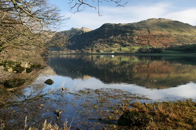
Brothers Water

Brothers Water is a small lake in the Hartsop valley, in the eastern region of the Lake District in England. Once called Broad Water, it lies at the northern...

Red Screes

Red Screes is a fell in the English Lake District, situated between the villages of Patterdale and Ambleside. It may be considered an outlier of the Fairfield...

Nearby Amenities

Located within 500m of 54.488492,-2.9376843
High Hartsop Dodd
Ele: 519
Natural: peak
Source: npe
Wikidata: Q5755591
Wikipedia: en:High Hartsop Dodd
Lat/Long: 54.4885401/-2.9378004
Bull Crag
Place: locality
Lat/Long: 54.4908927/-2.9377823
Bell Knott
Place: locality
Lat/Long: 54.490077/-2.9367189
Caiston Glen
Place: locality
Lat/Long: 54.4850327/-2.9332962
Barrier: stile
Ele: 364
Material: wood
Stile: stepover
Lat/Long: 54.4918684/-2.9348574
Savins
Place: locality
Lat/Long: 54.4886875/-2.9354792
The data included in this document is from www.openstreetmap.org. The data is made available under ODbL.

Have you been to High Hartsop Dodd?

Leave your review of High Hartsop Dodd below (or comments, questions and feedback).