Cairn Trench

Hill, Mountain in Angus

Scotland

Cairn Trench

Mountain hare on Black Shank
Mountain hare on Black Shank Credit: Alan Reid

Cairn Trench is a prominent hill located in the county of Angus, Scotland. Situated near the village of Glen Esk, it is part of the Grampian Mountains range. Rising to an elevation of approximately 633 meters (2,077 feet), Cairn Trench offers breathtaking panoramic views of the surrounding landscape.

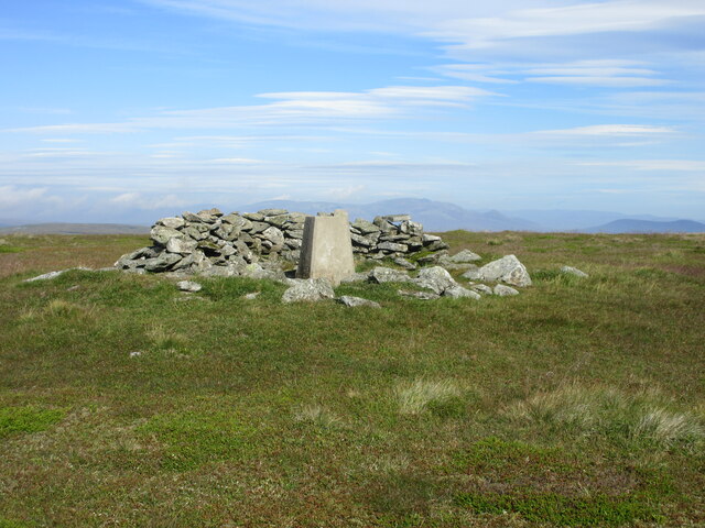
This hill is characterized by its distinctive cairn, a man-made pile of stones, located at its summit. The cairn serves as a historical marker, potentially indicating an ancient burial site or a navigational landmark. Its origins and significance remain shrouded in mystery, adding intrigue to the hill's allure.

Cairn Trench is a popular destination for outdoor enthusiasts and hikers due to its accessible location and stunning vistas. A well-defined path leads visitors through heather-covered moorlands and rocky terrain, gradually ascending towards the summit. Along the way, one can appreciate the diverse flora and fauna that thrive in this rugged environment.

As visitors reach the top, they are rewarded with breathtaking views of the surrounding Angus countryside. On a clear day, it is possible to see as far as the North Sea and the Cairngorms National Park. The expansive vistas provide a sense of serenity and tranquility, making Cairn Trench a perfect spot for contemplation or a picnic.

Overall, Cairn Trench in Angus is a captivating hill that offers a blend of natural beauty, historical intrigue, and outdoor adventure. Whether one seeks to conquer its summit or simply immerse themselves in the surrounding wilderness, this hill provides a memorable experience for all who visit.

If you have any feedback on the listing, please let us know in the comments section below.

Cairn Trench Images

Images are sourced within 2km of 56.857655/-2.9987971 or Grid Reference NO3974. Thanks to Geograph Open Source API. All images are credited.

Mountain hare on Black Shank
Summit of Ben Tirran (The Goet) The Corbetts are peaks in Scotland that are between 2,500 and 3,000 feet (762.0 and 914.4 m) high with a prominence of at least 500 feet (152.4 m)
Summit of Ben Tirran (The Goet)
The Corbetts are peaks in Scotland that are between 2,500 and 3,000 feet (762.0 and 914.4 m) high with a prominence of at least 500 feet (152.4 m)
Ben Tirran (trig point) The trig point on Ben Tirran
Ben Tirran (trig point)
The trig point on Ben Tirran
Trig Point on The Goet, Ben Tirran
Cairn, The Goet The summit of Ben Tirran, a vast plateau above Glen Clova.  It surrounds a triangulation pillar.
Cairn, The Goet
The summit of Ben Tirran, a vast plateau above Glen Clova. It surrounds a triangulation pillar.
The Goet Trig Pillar Triangulation pillar on the summit of The Goet, looking north-west with Lochnagar beyond on the horizon.
The Goet Trig Pillar
Triangulation pillar on the summit of The Goet, looking north-west with Lochnagar beyond on the horizon.
Low down on the eastern slope of Ben Tirran Walking up the Burn of Lochanluie into the corrie of the same name, whose craggy headwall is visible in the distance.
Low down on the eastern slope of Ben Tirran
Walking up the Burn of Lochanluie into the corrie of the same name, whose craggy headwall is visible in the distance.
The burn of Lochanluie Nearing the corrie that contains Lochanluie, this is the burn that drains the area.
The burn of Lochanluie
Nearing the corrie that contains Lochanluie, this is the burn that drains the area.
Lochanluie and the Goet Burn The burn beyond the small, rather boggy lochan, drains the col between The Goet and Ben Tirran - it disappears into the rocks on the hillside at about 1800', roughly where the grassy tongue extends down the slope.
Lochanluie and the Goet Burn
The burn beyond the small, rather boggy lochan, drains the col between The Goet and Ben Tirran - it disappears into the rocks on the hillside at about 1800', roughly where the grassy tongue extends down the slope.
Looking down the Burn of Lochanluie
Cairn beside the Craig Burn Not marked on the maps, but this cairn sits beside the burn, and 'feels' rather old - I guess it dates from the times of the shielings that must exist in this area, although most evidence of them lies buried under the heather.
Cairn beside the Craig Burn
Not marked on the maps, but this cairn sits beside the burn, and 'feels' rather old - I guess it dates from the times of the shielings that must exist in this area, although most evidence of them lies buried under the heather.
Across the corrie of Lochanluie towards the southern ridge of Ben Tirran From the small <a href="https://www.geograph.org.uk/photo/2882488">NO3873 : Cairn beside the Craig Burn</a>, looking across to the ridge the extends southwards from Ben Tirran. The whole area is extensively managed for grouse, of which there were plenty around.
Across the corrie of Lochanluie towards the southern ridge of Ben Tirran
From the small NO3873 : Cairn beside the Craig Burn, looking across to the ridge the extends southwards from Ben Tirran. The whole area is extensively managed for grouse, of which there were plenty around.
Large herd of Red Deer heading upwards Alarmed by the sudden, and presumably unusual, appearance of two walkers in 'their' corrie, this herd of 80-100 deer legged it up the hill beside Matthew's Burn.
Large herd of Red Deer heading upwards
Alarmed by the sudden, and presumably unusual, appearance of two walkers in 'their' corrie, this herd of 80-100 deer legged it up the hill beside Matthew's Burn.
Looking up Matthew's Burn The burn drains the southern and eastern sides of The Goet and Cairn Trench.
Looking up Matthew's Burn
The burn drains the southern and eastern sides of The Goet and Cairn Trench.
Fleurs corrie This small burn drains the corrie called Fleurs. The sunlit distant ridge is the southern extension of the Corbett of Ben Tirran.
Fleurs corrie
This small burn drains the corrie called Fleurs. The sunlit distant ridge is the southern extension of the Corbett of Ben Tirran.
Unnamed burn on the west side of White Hill A small waterslide and plunge pool on this minor burn, which is a tributary of the Burn of Fleurs.
Unnamed burn on the west side of White Hill
A small waterslide and plunge pool on this minor burn, which is a tributary of the Burn of Fleurs.
Looking up the minor burn The burn joins the Burn of Fleurs lower down in the corrie, but is unnamed in its upper reaches.
Looking up the minor burn
The burn joins the Burn of Fleurs lower down in the corrie, but is unnamed in its upper reaches.
High up the burn In a very distinctive V-shaped valley, the burn here is still actively cutting its way into the hillside.
High up the burn
In a very distinctive V-shaped valley, the burn here is still actively cutting its way into the hillside.
Show me another place!

Cairn Trench is located at Grid Ref: NO3974 (Lat: 56.857655, Lng: -2.9987971)

Unitary Authority: Angus

Police Authority: Tayside

What 3 Words

///renamed.social.unusable. Near Kirriemuir, Angus

Nearby Locations

Cairn Trench

Related Wikis

Ben Tirran

Ben Tirran (896 m) is a mountain in the Grampian Mountains of Scotland. It lies in the vast Mounth area of the eastern Highlands in Angus, on the northern...

Falls of Damff

Falls of Damff is a waterfall in Cairngorms National Park in Scotland. == See also == Waterfalls of Scotland == References ==

Five Glens of Angus

The Five Glens of Angus are the five Highland glens located in the western portion of the Angus region of Scotland. The five glens from westernmost to...

Loch Lee

National grid reference NO431800 Loch Lee is a loch in Angus, Scotland south of the Grampian Mountains that is fed by the Water of Lee and the Water of...

Nearby Amenities

Located within 500m of 56.857655,-2.9987971
Cairn Trench
Ele: 798
Natural: peak
Lat/Long: 56.8574235/-2.998839
The data included in this document is from www.openstreetmap.org. The data is made available under ODbL.

Have you been to Cairn Trench?

Leave your review of Cairn Trench below (or comments, questions and feedback).