Glenwhinnie Hill

Hill, Mountain in Midlothian

Scotland

Glenwhinnie Hill

Summit, The Struther Rough ground, grazed by horses. They stayed lower down the hill as it was rather windy.
Summit, The Struther Credit: Richard Webb

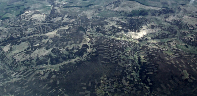
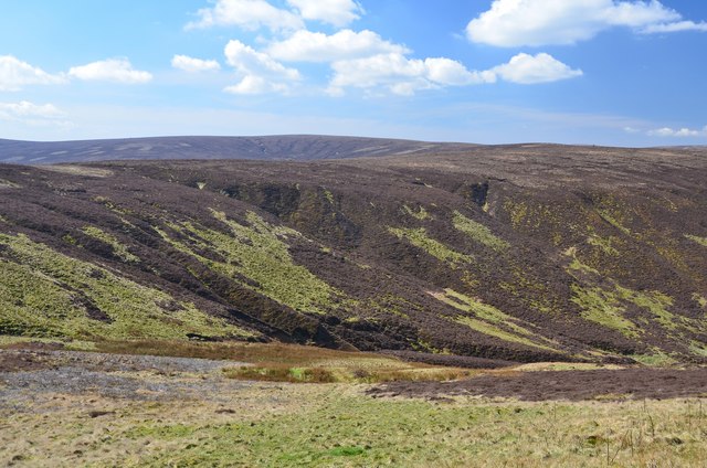
Glenwhinnie Hill is a prominent hill located in Midlothian, Scotland. Situated in the southern part of the county, it is part of the larger Pentland Hills range. The hill is known for its picturesque landscapes and provides an excellent vantage point to enjoy panoramic views of the surrounding countryside.

At an elevation of approximately 335 meters (1,099 feet), Glenwhinnie Hill is not the highest peak in the Pentland Hills, but it still offers a challenging climb for outdoor enthusiasts. The hill is covered in heather and grass, creating a colorful and vibrant landscape, especially during the summer months.

The area surrounding Glenwhinnie Hill is rich in biodiversity, with a variety of flora and fauna inhabiting the hillside. Hikers and nature enthusiasts can expect to encounter various species of birds, including peregrine falcons and red grouse, as well as mammals such as rabbits and deer.

The hill is a popular destination for outdoor activities such as hiking, walking, and photography. There are several well-marked trails that lead to the summit, offering visitors different routes to explore the hill. On a clear day, it is possible to see as far as Edinburgh and the Firth of Forth from the top.

Overall, Glenwhinnie Hill is a beautiful and accessible natural landmark in Midlothian, offering visitors a chance to connect with nature and enjoy breathtaking views of the Scottish countryside.

If you have any feedback on the listing, please let us know in the comments section below.

Glenwhinnie Hill Images

Images are sourced within 2km of 55.712887/-2.9762886 or Grid Reference NT3847. Thanks to Geograph Open Source API. All images are credited.

Summit, The Struther Rough ground, grazed by horses. They stayed lower down the hill as it was rather windy.
Summit, The Struther
Rough ground, grazed by horses. They stayed lower down the hill as it was rather windy.
Young hedge, Caddams Cleuch The shelterbelt was doing its work today, much more windy on the other side, on The Struther.
Young hedge, Caddams Cleuch
The shelterbelt was doing its work today, much more windy on the other side, on The Struther.
Fountainhall from the air Shining Pool Wood is to the right and the wind farms at Hartside Hill and Dun Law can be seen in the distance. Viewed from a flight from Prague, heading for Edinburgh.
Fountainhall from the air
Shining Pool Wood is to the right and the wind farms at Hartside Hill and Dun Law can be seen in the distance. Viewed from a flight from Prague, heading for Edinburgh.
Town Law from the air Hazelbank Quarry can be seen to the left, with part of Toddleburn wind farm on the extreme left. Viewed from a flight from Prague, heading for Edinburgh.
Town Law from the air
Hazelbank Quarry can be seen to the left, with part of Toddleburn wind farm on the extreme left. Viewed from a flight from Prague, heading for Edinburgh.
Deaf Heights from the air Shining Pool Wood can be seen top, centre. Viewed from a flight from Prague, heading for Edinburgh.
Deaf Heights from the air
Shining Pool Wood can be seen top, centre. Viewed from a flight from Prague, heading for Edinburgh.
Glenwhinnie Hill from the air The patchwork pattern indicates that the moorland is managed for game bird shooting.
Glenwhinnie Hill from the air
The patchwork pattern indicates that the moorland is managed for game bird shooting.
Fence on Rawburn Head Looking northwards over grouse moor to the turbines of Carcant wind farm.
Fence on Rawburn Head
Looking northwards over grouse moor to the turbines of Carcant wind farm.
Bend in the track, Rawburn Head The track bends to the east here a short distance S of the 542m spot height.
Bend in the track, Rawburn Head
The track bends to the east here a short distance S of the 542m spot height.
Head of the Raw Burn The head of the valley with Ladyside Height and Eastside Heights in the background.
Head of the Raw Burn
The head of the valley with Ladyside Height and Eastside Heights in the background.
Hill track at George Wood An estate track past the plantation on open moorland at over 500m.
Hill track at George Wood
An estate track past the plantation on open moorland at over 500m.
George Wood, Mount Main A sketchy track passes the scattered trees in this old plantation high on Mount Main, whose summit is R of centre in this view.
George Wood, Mount Main
A sketchy track passes the scattered trees in this old plantation high on Mount Main, whose summit is R of centre in this view.
Trig point, Mount Main summit The highest point (516m) of this moorland hill looking NE towards Lauderdale with the Toddleburn wind farm in view.
Trig point, Mount Main summit
The highest point (516m) of this moorland hill looking NE towards Lauderdale with the Toddleburn wind farm in view.
Looking SW from Mount Main summit George Wood is in the middle distance, separated by an expanse of strength-sapping tussock grass and heather.
Looking SW from Mount Main summit
George Wood is in the middle distance, separated by an expanse of strength-sapping tussock grass and heather.
Fence on Mount Main An old boundary wall and a parallel fence with Mt Main's summit trig point on the skyline.
Fence on Mount Main
An old boundary wall and a parallel fence with Mt Main's summit trig point on the skyline.
Town Law plantations above Fountainhall Watherston Hill is at top right <a href="https://www.geograph.org.uk/photo/5614222">NT4246 : Forestry on Watherston Hill</a>. The remains of the first snow of winter can be seen.
Town Law plantations above Fountainhall
Watherston Hill is at top right NT4246 : Forestry on Watherston Hill. The remains of the first snow of winter can be seen.
Robot on Ladyside Height near Heriot in the Scottish Borders
Should Ladyside Height be on your list this is the track to follow An hill in the Scottish Borders.
Should Ladyside Height be on your list this is the track to follow
An hill in the Scottish Borders.
View east off Ladyside Height near Heriot in the Scottish Borders
Show me another place!

Glenwhinnie Hill is located at Grid Ref: NT3847 (Lat: 55.712887, Lng: -2.9762886)

Unitary Authority: The Scottish Borders

Police Authority: The Lothians and Scottish Borders

What 3 Words

///deflate.perfumes.walled. Near Innerleithen, Scottish Borders

Nearby Locations

Glenwhinnie Hill

Related Wikis

Peatrig Hill

Peatrig Hill is a minor hill in Scotland, located about 15 km south-southeast of Edinburgh. One of the Moorfoot Hills, it is located in the parish of Heriot...

Windlestraw Law

Windlestraw Law is a hill in the Moorfoot Hills range, part of the Southern Uplands of Scotland. It is the highest peak of the range, and lies north of...

Dewar, Scottish Borders

Dewar is a village by the Dewar Burn and Peatrig Hill, in the Scottish Borders area of Scotland. Places nearby include Allanshaugh, Borthwick Hall, Fountainhall...

Fountainhall railway station

Fountainhall railway station served the village of Fountainhall, Scottish Borders from 1848 to 1969 on the Waverley Route. == History == The station opened...

Allanshaugh

Allanshaugh is a fermtoun in the Scottish Borders area of Scotland. == See also == List of places in the Scottish Borders List of places in Scotland...

Garvald, Scottish Borders

Garvald (Scots: Garvit) is a hamlet on the B7007, near Dewar, by the Dewar Burn, in the Moorfoot Hills, in the Scottish Borders area of Scotland, in the...

Halltree

Halltree is a hamlet in the Scottish Borders. == Etymology == The etymology of Halltree is debated, but the second element is likely to be a Cumbric word...

Heriot, Scottish Borders

Heriot is a small village in the Moorfoot Hills southeast of Edinburgh, Scotland, within Eildon (part of the Scottish Borders council area, though historically...

Nearby Amenities

Located within 500m of 55.712887,-2.9762886
Glenwhinnie Hill
Ele: 560
Natural: peak
Lat/Long: 55.7129148/-2.9763166
The data included in this document is from www.openstreetmap.org. The data is made available under ODbL.

Have you been to Glenwhinnie Hill?

Leave your review of Glenwhinnie Hill below (or comments, questions and feedback).