White Hillock

Hill, Mountain in Aberdeenshire

Scotland

White Hillock

Heather moorland with rock outcrop on Mullachdubh Mullachdubh is a minor, subsidiary top of Mona Gowan known to aficionados of hill lists as a 'Graham top of a Graham'! The highest point of the hill lies across the gentle slope ahead in the image. Morven is the distant mountain.
Heather moorland with rock outcrop on Mullachdubh Credit: Trevor Littlewood

White Hillock is a prominent hill located in Aberdeenshire, Scotland. Standing at an elevation of around 536 meters (1,759 feet), it forms part of the Grampian Mountains range. The hill is situated approximately 10 kilometers (6 miles) southwest of the town of Huntly.

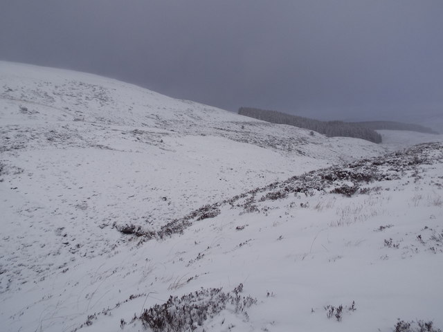
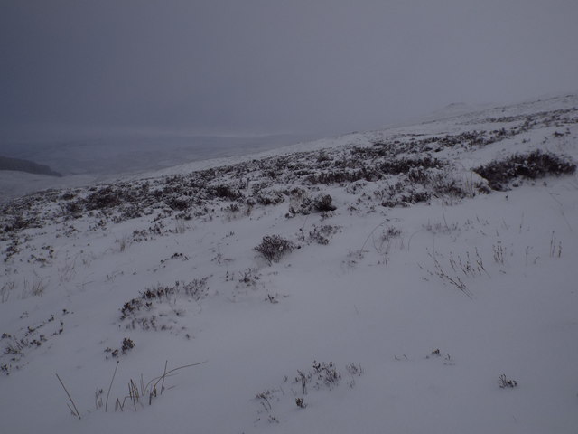
White Hillock is characterized by its distinctive shape, with a gently sloping side leading to a rounded summit. The hill is primarily composed of granite, which is common in the region. Its white appearance, which gives it its name, is due to the exposed quartz veins that run through the rock.

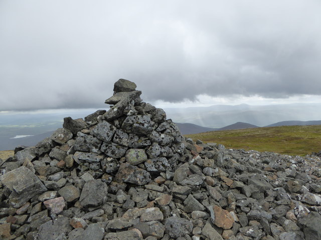
The hill offers breathtaking panoramic views of the surrounding countryside. From the summit, visitors can admire the rolling hills, lush farmland, and scattered woodlands that typify the Aberdeenshire landscape. On clear days, it is even possible to see as far as the North Sea coastline.

White Hillock is a popular destination for outdoor enthusiasts, particularly hikers and nature lovers. Several well-marked trails traverse the hill, allowing visitors to explore its diverse flora and fauna. The area is home to a variety of bird species, including buzzards and pheasants, making it a haven for birdwatchers.

Due to its accessibility and picturesque surroundings, White Hillock attracts both locals and tourists throughout the year. Whether it is for a leisurely stroll, a challenging hike, or simply to enjoy the tranquility of the Scottish countryside, White Hillock offers a memorable experience for all who visit.

If you have any feedback on the listing, please let us know in the comments section below.

White Hillock Images

Images are sourced within 2km of 57.133608/-3.0463987 or Grid Reference NJ3605. Thanks to Geograph Open Source API. All images are credited.

Heather moorland with rock outcrop on Mullachdubh Mullachdubh is a minor, subsidiary top of Mona Gowan known to aficionados of hill lists as a 'Graham top of a Graham'! The highest point of the hill lies across the gentle slope ahead in the image. Morven is the distant mountain.
Heather moorland with rock outcrop on Mullachdubh
Mullachdubh is a minor, subsidiary top of Mona Gowan known to aficionados of hill lists as a 'Graham top of a Graham'! The highest point of the hill lies across the gentle slope ahead in the image. Morven is the distant mountain.
Morven Summit View south-east towards Loch Davan from the top of 872m high Morven.
<span class="nowrap"><a title="www.royal-deeside.org.uk" rel="nofollow ugc noopener" href="http://www.royal-deeside.org.uk">Link</a><img style="margin-left:2px;" alt="External link" title="External link - shift click to open in new window" src="https://s1.geograph.org.uk/img/external.png" width="10" height="10"/></span>
Morven Summit
View south-east towards Loch Davan from the top of 872m high Morven. LinkExternal link
Lochnagar from Morven Looking south-westwards from the summit of Morven, over the Dee Valley, to lofty Lochnagar (a Munro).
<span class="nowrap"><a title="www.royal-deeside.org.uk" rel="nofollow ugc noopener" href="http://www.royal-deeside.org.uk">Link</a><img style="margin-left:2px;" alt="External link" title="External link - shift click to open in new window" src="https://s1.geograph.org.uk/img/external.png" width="10" height="10"/></span>
Lochnagar from Morven
Looking south-westwards from the summit of Morven, over the Dee Valley, to lofty Lochnagar (a Munro). LinkExternal link
Allt a' Bho The burn can be heard flowing underground here with just a few small gaps where it can be seen.
Allt a' Bho
The burn can be heard flowing underground here with just a few small gaps where it can be seen.
North western slopes of Morven Grass, heather and juniper on the hillside with boggy ground below.
North western slopes of Morven
Grass, heather and juniper on the hillside with boggy ground below.
Morven from Geallaig Hill A brindled landscape across the lower slopes of Morven resulting from muirburn - seasonal burning of patches of heather moorland as a means of habitat management for grouse. Towards the summit the underlying rock changes, the soil does not support heather and the muirburn stops.
Morven from Geallaig Hill
A brindled landscape across the lower slopes of Morven resulting from muirburn - seasonal burning of patches of heather moorland as a means of habitat management for grouse. Towards the summit the underlying rock changes, the soil does not support heather and the muirburn stops.
Looking east from the Braes of Fintock near Strathdon
Trees on the Braes of Fintock near Strathdon
View south in a snow shower from Braes of Fintock near Strathdon
Burn coming out of Braes of Fintock near Strathdon
Braes of Fintock near Strathdon
Heathery slopes of White Hillock near Braes of Fintock
Forest boundary climbing Mullachdubh near Braes of Fintock
Western slopes of Morven A runner on the slopes of Morven on day 2 of the 2 day Grampian Mountain Challenge <span class="nowrap"><a title="https://grampoc.com/2016/11/13/gmc-2016-morven/" rel="nofollow ugc noopener" href="https://grampoc.com/2016/11/13/gmc-2016-morven/">Link</a><img style="margin-left:2px;" alt="External link" title="External link - shift click to open in new window" src="https://s1.geograph.org.uk/img/external.png" width="10" height="10"/></span>
A second pair can be seen in the background
Western slopes of Morven
A runner on the slopes of Morven on day 2 of the 2 day Grampian Mountain Challenge LinkExternal link A second pair can be seen in the background
Hillside below Mid Cairn, Morven A patch of mossy, stony hillside, and a view towards Crannach Hill and Culblean Hill, in shadow.
Hillside below Mid Cairn, Morven
A patch of mossy, stony hillside, and a view towards Crannach Hill and Culblean Hill, in shadow.
Mid Cairn, Morven A navigational aid on the way to Morven's summit.
Mid Cairn, Morven
A navigational aid on the way to Morven's summit.
Summit cairn, Morven The cairn takes Morven (name derived from mor bheinn - 'big hill' in Gaelic) to a height of 872 metres above sea level.
Summit cairn, Morven
The cairn takes Morven (name derived from mor bheinn - 'big hill' in Gaelic) to a height of 872 metres above sea level.
Morven A very long telephoto view of Morven, near Aboyne in Deeside.
Morven
A very long telephoto view of Morven, near Aboyne in Deeside.
Show me another place!

White Hillock is located at Grid Ref: NJ3605 (Lat: 57.133608, Lng: -3.0463987)

Unitary Authority: Aberdeenshire

Police Authority: North East

What 3 Words

///streetcar.compose.snug. Near Ballater, Aberdeenshire

Related Wikis

Morven, Aberdeenshire

Morven (Scottish Gaelic: A' Mhòr Bheinn) is a Corbett in Aberdeenshire, Scotland. It is 871 m (2858 ft) high. The poet, Lord Byron, who spent some of his...

Blue cairn circle

Blue cairn circle is a 21 metres (69 ft) diameter stone circle in Aberdeenshire, Scotland. In the center is a large stone cairn with several pits in it...

Logie Coldstone

Logie Coldstone (Scottish Gaelic: Lògaidh) is a village in Aberdeenshire, Scotland. The village lies north of the River Dee, near Tarland in the Cromar...

Migvie Castle

Migvie Castle was a 13th-century castle to the west of Migvie, Aberdeenshire, Scotland. Its remains were listed as a scheduled monument in 2007. ��2�...

Castle Newe

Castle Newe was a castellated mansion house, situated in Aberdeenshire, and designed in 1831 by Archibald Simpson. It was based on an existing Z-plan castle...

Colquhonnie Castle

Colquhonnie Castle is a ruined 16th-century tower house, about 10.5 miles (16.9 km) north of Ballater, Aberdeenshire, Scotland, around 1.0 mile (1.6 km...

Blelack

Blelack (, Scottish Gaelic: Blàth Bholg) is a place in Aberdeenshire, Scotland, the location of Blelack House, a Scottish mansion house with origins in...

Bellabeg

Bellabeg (an anglicisation of Scottish Gaelic: Am Baile Beag, 'the small farmtown') is a small roadside settlement in Strathdon, Aberdeenshire, Scotland...

Have you been to White Hillock?

Leave your review of White Hillock below (or comments, questions and feedback).