Braes of Fintock

Downs, Moorland in Aberdeenshire

Scotland

Braes of Fintock

East side of Slacks of Glencarvie The Slacks of Glencarvie is the name given to a bouldery cleft to the east of Mona Gowan; here, the south end of it is viewed from the Mona Gowan side with the Corbett, Morven being seen beyond.
East side of Slacks of Glencarvie Credit: Trevor Littlewood

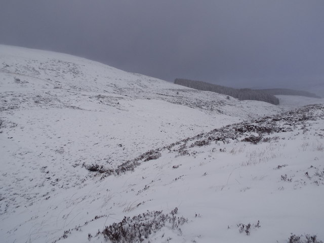
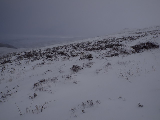
The Braes of Fintock, located in Aberdeenshire, Scotland, is a picturesque area characterized by its downs and moorland landscapes. Situated amidst rolling hills, this region offers breathtaking views and a tranquil environment. The downs, or gently sloping hills, provide a scenic backdrop with their lush greenery and occasional clusters of trees. The moorland, on the other hand, boasts vast expanses of open grassland, heather, and peat bogs.

The Braes of Fintock is a haven for wildlife enthusiasts, as it is home to a diverse range of flora and fauna. The downs are dotted with various wildflowers, adding bursts of color to the landscape. The moorland is known for its heather, which blankets the area in vibrant purples during the summer months. Birdwatchers can spot a variety of species, including red grouse, skylarks, and golden plovers.

This region also offers a range of recreational activities for outdoor enthusiasts. Hiking and walking trails crisscross the area, allowing visitors to explore its natural beauty on foot. Additionally, the Braes of Fintock is a popular destination for mountain biking, with its undulating terrain providing an enjoyable challenge for riders.

The natural beauty, peaceful ambiance, and diverse wildlife make the Braes of Fintock a must-visit destination for nature lovers and outdoor enthusiasts alike. Whether it's admiring the rolling downs, exploring the moorland, or embarking on a scenic hike, this area in Aberdeenshire offers a truly memorable experience.

If you have any feedback on the listing, please let us know in the comments section below.

Braes of Fintock Images

Images are sourced within 2km of 57.133576/-3.056674 or Grid Reference NJ3605. Thanks to Geograph Open Source API. All images are credited.

East side of Slacks of Glencarvie The Slacks of Glencarvie is the name given to a bouldery cleft to the east of Mona Gowan; here, the south end of it is viewed from the Mona Gowan side with the Corbett, Morven being seen beyond.
East side of Slacks of Glencarvie
The Slacks of Glencarvie is the name given to a bouldery cleft to the east of Mona Gowan; here, the south end of it is viewed from the Mona Gowan side with the Corbett, Morven being seen beyond.
Heather moorland with rock outcrop on Mullachdubh Mullachdubh is a minor, subsidiary top of Mona Gowan known to aficionados of hill lists as a 'Graham top of a Graham'! The highest point of the hill lies across the gentle slope ahead in the image. Morven is the distant mountain.
Heather moorland with rock outcrop on Mullachdubh
Mullachdubh is a minor, subsidiary top of Mona Gowan known to aficionados of hill lists as a 'Graham top of a Graham'! The highest point of the hill lies across the gentle slope ahead in the image. Morven is the distant mountain.
Morven Summit View south-east towards Loch Davan from the top of 872m high Morven.
<span class="nowrap"><a title="www.royal-deeside.org.uk" rel="nofollow ugc noopener" href="http://www.royal-deeside.org.uk">Link</a><img style="margin-left:2px;" alt="External link" title="External link - shift click to open in new window" src="https://s1.geograph.org.uk/img/external.png" width="10" height="10"/></span>
Morven Summit
View south-east towards Loch Davan from the top of 872m high Morven. LinkExternal link
Lochnagar from Morven Looking south-westwards from the summit of Morven, over the Dee Valley, to lofty Lochnagar (a Munro).
<span class="nowrap"><a title="www.royal-deeside.org.uk" rel="nofollow ugc noopener" href="http://www.royal-deeside.org.uk">Link</a><img style="margin-left:2px;" alt="External link" title="External link - shift click to open in new window" src="https://s1.geograph.org.uk/img/external.png" width="10" height="10"/></span>
Lochnagar from Morven
Looking south-westwards from the summit of Morven, over the Dee Valley, to lofty Lochnagar (a Munro). LinkExternal link
The Slacks of Glencarvie and Castle Wilson, zoomed in from 1350m below
Allt a' Bho The burn can be heard flowing underground here with just a few small gaps where it can be seen.
Allt a' Bho
The burn can be heard flowing underground here with just a few small gaps where it can be seen.
North western slopes of Morven Grass, heather and juniper on the hillside with boggy ground below.
North western slopes of Morven
Grass, heather and juniper on the hillside with boggy ground below.
Tussock grass NE of The Tom Boggy moorland with tussock grass, juniper, rushes and some heather.
Tussock grass NE of The Tom
Boggy moorland with tussock grass, juniper, rushes and some heather.
Juniper and tussock grass Between Allt a'Bhreabair and Allt a' Bho, west of Morven.  Low juniper bushes growing amongst boggy ground with tussock grass.
Juniper and tussock grass
Between Allt a'Bhreabair and Allt a' Bho, west of Morven. Low juniper bushes growing amongst boggy ground with tussock grass.
Looking east from the Braes of Fintock near Strathdon
Trees on the Braes of Fintock near Strathdon
View south in a snow shower from Braes of Fintock near Strathdon
Burn coming out of Braes of Fintock near Strathdon
Braes of Fintock near Strathdon
Heathery slopes of White Hillock near Braes of Fintock
Forest boundary climbing Mullachdubh near Braes of Fintock
Western slopes of Morven A runner on the slopes of Morven on day 2 of the 2 day Grampian Mountain Challenge <span class="nowrap"><a title="https://grampoc.com/2016/11/13/gmc-2016-morven/" rel="nofollow ugc noopener" href="https://grampoc.com/2016/11/13/gmc-2016-morven/">Link</a><img style="margin-left:2px;" alt="External link" title="External link - shift click to open in new window" src="https://s1.geograph.org.uk/img/external.png" width="10" height="10"/></span>
A second pair can be seen in the background
Western slopes of Morven
A runner on the slopes of Morven on day 2 of the 2 day Grampian Mountain Challenge LinkExternal link A second pair can be seen in the background
Summit cairn, Morven The cairn takes Morven (name derived from mor bheinn - 'big hill' in Gaelic) to a height of 872 metres above sea level.
Summit cairn, Morven
The cairn takes Morven (name derived from mor bheinn - 'big hill' in Gaelic) to a height of 872 metres above sea level.
Show me another place!

Braes of Fintock is located at Grid Ref: NJ3605 (Lat: 57.133576, Lng: -3.056674)

Unitary Authority: Aberdeenshire

Police Authority: North East

What 3 Words

///whips.unionists.horses. Near Ballater, Aberdeenshire

Related Wikis

Morven, Aberdeenshire

Morven (Scottish Gaelic: A' Mhòr Bheinn) is a Corbett in Aberdeenshire, Scotland. It is 871 m (2858 ft) high. The poet, Lord Byron, who spent some of his...

Blue cairn circle

Blue cairn circle is a 21 metres (69 ft) diameter stone circle in Aberdeenshire, Scotland. In the center is a large stone cairn with several pits in it...

Castle Newe

Castle Newe was a castellated mansion house, situated in Aberdeenshire, and designed in 1831 by Archibald Simpson. It was based on an existing Z-plan castle...

Colquhonnie Castle

Colquhonnie Castle is a ruined 16th-century tower house, about 10.5 miles (16.9 km) north of Ballater, Aberdeenshire, Scotland, around 1.0 mile (1.6 km...

Bellabeg

Bellabeg (an anglicisation of Scottish Gaelic: Am Baile Beag, 'the small farmtown') is a small roadside settlement in Strathdon, Aberdeenshire, Scotland...

Logie Coldstone

Logie Coldstone (Scottish Gaelic: Lògaidh) is a village in Aberdeenshire, Scotland. The village lies north of the River Dee, near Tarland in the Cromar...

Strathdon

Strathdon (; Gaelic: Srath Dheathain) is an area in Aberdeenshire, Scotland. It is situated in the strath of the River Don, 45 miles west of Aberdeen in...

Migvie Castle

Migvie Castle was a 13th-century castle to the west of Migvie, Aberdeenshire, Scotland. Its remains were listed as a scheduled monument in 2007. ��2�...

Have you been to Braes of Fintock?

Leave your review of Braes of Fintock below (or comments, questions and feedback).