Black Rig

Hill, Mountain in Selkirkshire

Scotland

Black Rig

Summit fence, Glengaber Hill Looking into Tweeddale from the angle in the newly replaced fence. Innerleithen is R of centre, Cardrona to the left with the turbines of Bowbeat Wind Farm on the skyline. Glengaber Hill is also named as Welldean Hill on its south side seen from the Yarrow side of the watershed.
Summit fence, Glengaber Hill Credit: Jim Barton

Black Rig is a prominent hill located in Selkirkshire, a historic county in the southern part of Scotland. Standing at an elevation of approximately 364 meters (1,194 feet), it is classified as a Marilyns, which is a designation given to hills or mountains with a prominence of at least 150 meters.

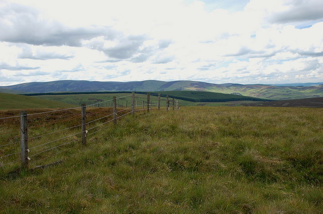
Situated on the eastern side of the Ettrick Valley, Black Rig offers stunning panoramic views of the surrounding countryside. Its distinctive shape and steep slopes make it a notable landmark in the area. The hill is covered in heather and grasses, creating a picturesque landscape that is particularly beautiful during the summer months.

Black Rig is a popular destination for hikers and outdoor enthusiasts due to its relatively easy access and well-defined paths. There are several routes to reach the summit, with the most common starting from the nearby village of Ettrickbridge. The ascent typically takes around 1-2 hours, depending on the chosen path and individual fitness levels.

Once atop Black Rig, visitors are rewarded with breathtaking vistas across the rolling hills and valleys of Selkirkshire. On clear days, it is possible to see as far as the Moffat Hills to the east and the Southern Uplands to the south. The hill also offers opportunities for birdwatching, with red grouse and kestrels frequently spotted in the area.

Overall, Black Rig in Selkirkshire is a captivating hill that provides an enjoyable outdoor experience for nature lovers and offers a chance to appreciate the stunning Scottish landscape.

If you have any feedback on the listing, please let us know in the comments section below.

Black Rig Images

Images are sourced within 2km of 55.568923/-3.0210018 or Grid Reference NT3531. Thanks to Geograph Open Source API. All images are credited.

Summit fence, Glengaber Hill Looking into Tweeddale from the angle in the newly replaced fence. Innerleithen is R of centre, Cardrona to the left with the turbines of Bowbeat Wind Farm on the skyline. Glengaber Hill is also named as Welldean Hill on its south side seen from the Yarrow side of the watershed.
Summit fence, Glengaber Hill
Looking into Tweeddale from the angle in the newly replaced fence. Innerleithen is R of centre, Cardrona to the left with the turbines of Bowbeat Wind Farm on the skyline. Glengaber Hill is also named as Welldean Hill on its south side seen from the Yarrow side of the watershed.
Fence junction, Glengaber Hill The new fence section ends at this junction above Welldean Hope.
Fence junction, Glengaber Hill
The new fence section ends at this junction above Welldean Hope.
Track on Welldean Hill
Watershed col, Welldean Hill The slopes to the left drain to the Tweed, those to the right to the Yarrow. The plantation is the southern edge of Elibank and Traquair Forest on Green Knowe.
Watershed col, Welldean Hill
The slopes to the left drain to the Tweed, those to the right to the Yarrow. The plantation is the southern edge of Elibank and Traquair Forest on Green Knowe.
Deuchar Hope This joins with Welldean Hope to the west and descends to Yarrow. Compare with a similar view <a href="https://www.geograph.org.uk/photo/1859987">NT3529 : Deuchar Hope</a> taken in 2011.
Deuchar Hope
This joins with Welldean Hope to the west and descends to Yarrow. Compare with a similar view NT3529 : Deuchar Hope taken in 2011.
Summit fence, Glengaber Hill A rounded and almost flat summit area; looking back across the forestry on Curly Moor to the Birkscairn - Dun Rig ridge above Glen Sax.
Summit fence, Glengaber Hill
A rounded and almost flat summit area; looking back across the forestry on Curly Moor to the Birkscairn - Dun Rig ridge above Glen Sax.
A track on Peatshank Head This track up to the col between Glengaber Hill and Peatshank Head was viewed from Deuchar Hill.
A track on Peatshank Head
This track up to the col between Glengaber Hill and Peatshank Head was viewed from Deuchar Hill.
A cairn on Peatshank Head This was viewed in mid-January towards Glengaber Hill. For a summer view of the cairn, see <a href="https://www.geograph.org.uk/photo/188523">NT3529 : Cairn, Peatshank Head.</a>.
A cairn on Peatshank Head
This was viewed in mid-January towards Glengaber Hill. For a summer view of the cairn, see NT3529 : Cairn, Peatshank Head..
A gate on Glengaber Hill This gate is at a junction of fences to the southeast of the summit.
A gate on Glengaber Hill
This gate is at a junction of fences to the southeast of the summit.
Flea Shank in mid-January This area of burnt heather is between Peatshank Head and Deuchar Hill. Cat Craig is on the left.
Flea Shank in mid-January
This area of burnt heather is between Peatshank Head and Deuchar Hill. Cat Craig is on the left.
A track on Glengaber Hill This track on a rough grazing hillside was viewed in mid-January.
A track on Glengaber Hill
This track on a rough grazing hillside was viewed in mid-January.
Welldean Hill This is a mid-January view south over Welldean Hope towards Whitehope Rig.
Welldean Hill
This is a mid-January view south over Welldean Hope towards Whitehope Rig.
Flea Shank A strong wind had blown snow off the ridge to the lee slope of the hill where it was knee deep. This was viewed in late March during a cold spell of weather.
Flea Shank
A strong wind had blown snow off the ridge to the lee slope of the hill where it was knee deep. This was viewed in late March during a cold spell of weather.
Summit, Cat Craig Good going over the hill on a quadbike track.
Summit, Cat Craig
Good going over the hill on a quadbike track.
Summit, Peatshank Head An unmarked moorland summit, sometimes grazed by cattle.
Summit, Peatshank Head
An unmarked moorland summit, sometimes grazed by cattle.
Glengaber Hill Heather on the north side of the hill.
Glengaber Hill
Heather on the north side of the hill.
Ridge between Glengaber Hill and Peatshank Hill
Top of Flea Shank View from Peatshank Head.
Top of Flea Shank
View from Peatshank Head.
Show me another place!

Black Rig is located at Grid Ref: NT3531 (Lat: 55.568923, Lng: -3.0210018)

Unitary Authority: The Scottish Borders

Police Authority: The Lothians and Scottish Borders

What 3 Words

///waggled.together.splints. Near Innerleithen, Scottish Borders

Nearby Locations

Black Rig

Related Wikis

Nearby Amenities

Located within 500m of 55.568923,-3.0210018
The data included in this document is from www.openstreetmap.org. The data is made available under ODbL.

Have you been to Black Rig?

Leave your review of Black Rig below (or comments, questions and feedback).