Nout Hill

Hill, Mountain in Selkirkshire

Scotland

Nout Hill

Track and path beside Yarrow Water at Yarrow Bridge Looking south-westward.
Track and path beside Yarrow Water at Yarrow Bridge Credit: Peter Wood

Nout Hill is a prominent hill located in Selkirkshire, a historic county in the Scottish Borders region of Scotland. It stands at an elevation of approximately 1,430 feet (436 meters) above sea level, making it a significant geographical feature in the area.

Situated near the village of Ettrickbridge, Nout Hill offers breathtaking panoramic views of the surrounding countryside. Its summit provides a vantage point where visitors can admire the picturesque landscapes, including the rolling hills, vast forests, and meandering rivers that characterize the region. On a clear day, it is even possible to see as far as the distant peaks of the Southern Uplands.

Nout Hill is a popular destination for outdoor enthusiasts, hikers, and nature lovers. There are various walking routes and trails that lead to the summit, catering to both experienced climbers and casual walkers. The ascent can be challenging but rewarding, with the opportunity to witness the diverse flora and fauna that thrive in this natural habitat.

This hill holds historical significance as well. It is believed to have been used as a beacon site during ancient times, with fires lit on its summit to communicate important messages across the region.

Overall, Nout Hill is a remarkable natural landmark that offers stunning views, recreational opportunities, and a glimpse into the rich history of Selkirkshire. Whether seeking adventure or tranquility, visitors to this hill are sure to be captivated by its beauty and charm.

If you have any feedback on the listing, please let us know in the comments section below.

Nout Hill Images

Images are sourced within 2km of 55.545895/-3.030247 or Grid Reference NT3528. Thanks to Geograph Open Source API. All images are credited.

Track and path beside Yarrow Water at Yarrow Bridge Looking south-westward.
Track and path beside Yarrow Water at Yarrow Bridge
Looking south-westward.
Minor road descending to Yarrow Bridge Looking north-westward with an early morning sun casting a long shadow.
Minor road descending to Yarrow Bridge
Looking north-westward with an early morning sun casting a long shadow.
A low flying RAF special tail Hercules This shot was taken from Crook Hill as ZH887 flew over Yarrowford on a low flying sortie. The RAF celebrated its 100th birthday on 1st April 2018 and to mark the occasion one of each aircraft type was marked with an RAF 100 tail sticker. Low level enthusiasts considered this to be a cheap option when painted schemes were expected.
A low flying RAF special tail Hercules
This shot was taken from Crook Hill as ZH887 flew over Yarrowford on a low flying sortie. The RAF celebrated its 100th birthday on 1st April 2018 and to mark the occasion one of each aircraft type was marked with an RAF 100 tail sticker. Low level enthusiasts considered this to be a cheap option when painted schemes were expected.
The Glebe Stone in the Yarrow Valley This 1.4m high standing stone is on the site of a former large cairn that covered a quantity of decomposed bones.
The Glebe Stone in the Yarrow Valley
This 1.4m high standing stone is on the site of a former large cairn that covered a quantity of decomposed bones.
A grazing field at Yarrow This is a view from the A708 towards Yarrow Bridge with Fastheugh Hill in the background.
A grazing field at Yarrow
This is a view from the A708 towards Yarrow Bridge with Fastheugh Hill in the background.
The Glebe Stone This 1.4m high standing stone is on the site of a former large cairn that covered a quantity of decomposed bones. Deuchar Hill is in the background to the left and Fastheugh Hill to the right.
The Glebe Stone
This 1.4m high standing stone is on the site of a former large cairn that covered a quantity of decomposed bones. Deuchar Hill is in the background to the left and Fastheugh Hill to the right.
The Yarrow Stone An early Christian stone approximately 4.5 feet in height. The Yarrow Stone was found during ploughing work during the early 19th century and has now been set upright, enclosed by a wooden fence. When found, it was lying flat, with the remains of human bones beneath it.
The Yarrow Stone
An early Christian stone approximately 4.5 feet in height. The Yarrow Stone was found during ploughing work during the early 19th century and has now been set upright, enclosed by a wooden fence. When found, it was lying flat, with the remains of human bones beneath it.
A fine symbolic stone in Yarrow Kirkyard This carved stone is lying flat, face upwards. It depicts the deceased holding a Bible above a skull and hour-glass, which show death and the passage of time. The carvings are in good condition.
A fine symbolic stone in Yarrow Kirkyard
This carved stone is lying flat, face upwards. It depicts the deceased holding a Bible above a skull and hour-glass, which show death and the passage of time. The carvings are in good condition.
Part of a symbolic stone in Yarrow Kirkyard The sunken stone conceals the lower part of the symbolic carving. The whole portrayal is shown on another stone <a href="https://www.geograph.org.uk/photo/7268379">NT3527 : A fine symbolic stone in Yarrow Kirkyard</a> behind the kirk building.
Part of a symbolic stone in Yarrow Kirkyard
The sunken stone conceals the lower part of the symbolic carving. The whole portrayal is shown on another stone NT3527 : A fine symbolic stone in Yarrow Kirkyard behind the kirk building.
In Yarrow Kirkyard Yarrow Kirkyard contains some interesting old symbolic stones. The one on the left shows a winged soul, portraying life after death, above a skull and crossed bones, portraying man's mortalilty. The one on the right shows a portrait of the deceased. Both stones have sunk into the ground. See also <a href="https://www.geograph.org.uk/photo/7268382">NT3527 : Part of a symbolic stone in Yarrow Kirkyard</a> and <a href="https://www.geograph.org.uk/photo/7268379">NT3527 : A fine symbolic stone in Yarrow Kirkyard</a>
In Yarrow Kirkyard
Yarrow Kirkyard contains some interesting old symbolic stones. The one on the left shows a winged soul, portraying life after death, above a skull and crossed bones, portraying man's mortalilty. The one on the right shows a portrait of the deceased. Both stones have sunk into the ground. See also NT3527 : Part of a symbolic stone in Yarrow Kirkyard and NT3527 : A fine symbolic stone in Yarrow Kirkyard
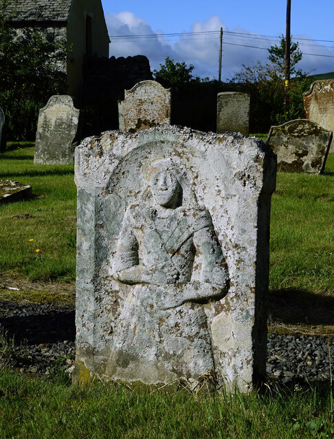
Yarrow Kirkyard gravestone This old carved stone shows a full portrait of the deceased. It's not possible to read the details on the other side but the carving is typical of 18th century Scotland.
Yarrow Kirkyard gravestone
This old carved stone shows a full portrait of the deceased. It's not possible to read the details on the other side but the carving is typical of 18th century Scotland.
Yarrow Kirk This wee kirk in Ettrick & Yarrow Parish hosts monthly Sunday services. The graveyard contains some interesting old carved stones.
Yarrow Kirk
This wee kirk in Ettrick & Yarrow Parish hosts monthly Sunday services. The graveyard contains some interesting old carved stones.
Yarrow view Viewed looking towards Deuchar Hill. The local war memorial is shown on the right among the trees.
Yarrow view
Viewed looking towards Deuchar Hill. The local war memorial is shown on the right among the trees.
Yarrow Valley view An upstream view taken after a long spell of dry summer weather.
Yarrow Valley view
An upstream view taken after a long spell of dry summer weather.
Track near Deuchar Looking towards Welldean Hill.
Track near Deuchar
Looking towards Welldean Hill.
A headstone detail at Yarrow Parish Kirkyard Lichen has obscured most of the inscription on this old headstone. For a view of the kirk and kirkyard, see <a href="https://www.geograph.org.uk/photo/7268391">NT3527 : Yarrow Kirk</a>.
A headstone detail at Yarrow Parish Kirkyard
Lichen has obscured most of the inscription on this old headstone. For a view of the kirk and kirkyard, see NT3527 : Yarrow Kirk.
An old gravestone in Yarrow Kirkyard The inscription reads:-

Her Lyes
James HENDER
SON LATE TEN
NANT IN MO
WNTT BANG
ER KNOU WHO
DYED JUNE 1772
AGED 73 YEARS

Mownnt Banger Knou will likely refer to the modern day Mountbenger
An old gravestone in Yarrow Kirkyard
The inscription reads:- Her Lyes James HENDER SON LATE TEN NANT IN MO WNTT BANG ER KNOU WHO DYED JUNE 1772 AGED 73 YEARS Mownnt Banger Knou will likely refer to the modern day Mountbenger
A gravestone at Yarrow Kirkyard The stone is inscribed:-

ERECTED
BY JOHN FORSYTH, AMERICA,
TO THE MEMORY OF HIS FATHER
 WALTER FORSYTH, TAILOR, WHO DIED
AT YARROWFUES 1ST JULY 1823,
AGED 41 YEARS,
AND
MARY HOGG HIS MOTHER, WHO DIED AT
SELKIRK 20TH MARCH 1867,
AGED 76 YEARS.
ALSO
ROBERT THEIR SON, WHO DIED 5TH JAN
1867 AGED 48 YEARS.
AND AGNES THEIR DAUGHTER WHO DIED AT
SELKIRK, 28TH NOVR 1884, AGED 64 YEARS.
JOHN THEIR SON DIED AT SELKIRK 20TH JANY
1890 AGED 72 YEARS.
WALTER THEIR SON DIED AT HALL’S CORNERS,
NEW YORK, U.S.A. 7TH JULY 1900
AGED 78 YEARS.
A gravestone at Yarrow Kirkyard
The stone is inscribed:- ERECTED BY JOHN FORSYTH, AMERICA, TO THE MEMORY OF HIS FATHER WALTER FORSYTH, TAILOR, WHO DIED AT YARROWFUES 1ST JULY 1823, AGED 41 YEARS, AND MARY HOGG HIS MOTHER, WHO DIED AT SELKIRK 20TH MARCH 1867, AGED 76 YEARS. ALSO ROBERT THEIR SON, WHO DIED 5TH JAN 1867 AGED 48 YEARS. AND AGNES THEIR DAUGHTER WHO DIED AT SELKIRK, 28TH NOVR 1884, AGED 64 YEARS. JOHN THEIR SON DIED AT SELKIRK 20TH JANY 1890 AGED 72 YEARS. WALTER THEIR SON DIED AT HALL’S CORNERS, NEW YORK, U.S.A. 7TH JULY 1900 AGED 78 YEARS.
Show me another place!

Nout Hill is located at Grid Ref: NT3528 (Lat: 55.545895, Lng: -3.030247)

Unitary Authority: The Scottish Borders

Police Authority: The Lothians and Scottish Borders

What 3 Words

///pulp.irrigated.squabbles. Near Innerleithen, Scottish Borders

Nearby Locations

Nout Hill

Related Wikis

Yarrow, Scottish Borders

Yarrow is a place and parish in the Scottish Borders area of Scotland and in the former county of Selkirkshire.The name "Yarrow" may derive from the Celtic...

Kirkhope Tower

Kirkhope Tower is a Scottish Pele, located in the Ettrick Valley, in the historic county of Selkirkshire, now a division of the Scottish Borders. The tower...

Selkirkshire

Selkirkshire or the County of Selkirk (Scottish Gaelic: Siorrachd Shalcraig) is a historic county and registration county of Scotland. It borders Peeblesshire...

Ettrickbridge

Ettrickbridge (Scottish Gaelic: Drochaid Eadaraig) is a village situated in the Scottish Borders region of Scotland, 7 miles (11 km) from the nearby town...

Have you been to Nout Hill?

Leave your review of Nout Hill below (or comments, questions and feedback).