Wee Hill

Hill, Mountain in Peeblesshire

Scotland

Wee Hill

Sheep pens near Blackhopebyre
Sheep pens near Blackhopebyre Credit: Steven Brown

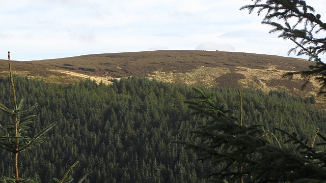
Wee Hill is a small but picturesque hill located in the Peeblesshire region of Scotland. Standing at an elevation of approximately 250 meters (820 feet), it is often referred to as a "wee" hill due to its modest height compared to the surrounding towering mountains. Despite its size, Wee Hill offers stunning panoramic views of the surrounding countryside, making it a popular destination for nature enthusiasts and hikers.

The hill is covered in lush greenery, with a diverse range of flora and fauna inhabiting its slopes. It is home to various species of birds, including skylarks and meadow pipits, which can be heard and seen throughout the year. The hillside is adorned with colorful wildflowers during the spring and summer months, creating a vibrant and enchanting atmosphere.

Wee Hill is easily accessible, with a well-maintained path leading to its summit. The path is suitable for walkers of all abilities, although caution is advised on steeper sections. As visitors ascend the hill, they are treated to breathtaking views of the surrounding Peeblesshire countryside, including rolling hills, meandering rivers, and distant peaks.

At the top of Wee Hill, there is a small cairn, providing a perfect spot for a well-deserved rest and the opportunity to soak in the beauty of the landscape. On clear days, it is possible to see as far as the Pentland Hills and the Southern Uplands. The hill's tranquil and serene atmosphere offers a welcome escape from the hustle and bustle of everyday life.

Overall, Wee Hill may be small in size, but it leaves a big impression on those who visit, offering a peaceful retreat and stunning natural beauty for all to enjoy.

If you have any feedback on the listing, please let us know in the comments section below.

Wee Hill Images

Images are sourced within 2km of 55.700666/-3.0472519 or Grid Reference NT3445. Thanks to Geograph Open Source API. All images are credited.

Sheep pens near Blackhopebyre
Small plantation of trees
B709, Dewar Gill
B709, Dewar Gill
Cairn on summit of Whitehope Law near Innerleithen There are no paths to the summit.
Cairn on summit of Whitehope Law near Innerleithen
There are no paths to the summit.
Descending NE by fence from Whitehope Law near Innerleithen
Sheepfold within the forest, Williamslee Hope A sheepfold near the foot of the ridge between North Grain and South Grain at the head of Williamslee Burn.
Sheepfold within the forest, Williamslee Hope
A sheepfold near the foot of the ridge between North Grain and South Grain at the head of Williamslee Burn.
Track by Williamslee Burn The Williamslee Burn is formed by the union of North Grain and South Grain, streams that drain the peat moorland south of Blackhope Scar.
Track by Williamslee Burn
The Williamslee Burn is formed by the union of North Grain and South Grain, streams that drain the peat moorland south of Blackhope Scar.
Head of South Grain The start of one of the steep sided glens running down to the Leithen Water. The sheltered ground is planted with conifers, while the going on the moorland is abominable.
Head of South Grain
The start of one of the steep sided glens running down to the Leithen Water. The sheltered ground is planted with conifers, while the going on the moorland is abominable.
Head of South Grain Peat bog and moorland on the Moorfoot Hills, appalling going underfoot.
Head of South Grain
Peat bog and moorland on the Moorfoot Hills, appalling going underfoot.
Garvald Punks Without the icy snow covering of my last visit: <a href="https://www.geograph.org.uk/photo/1690751">NT3247 : Garvald Punks</a>, the true horror of Garvald Punks is experienced.
Garvald Punks
Without the icy snow covering of my last visit: NT3247 : Garvald Punks, the true horror of Garvald Punks is experienced.
Middle Hill View of Middle Hill from the west.
Middle Hill
View of Middle Hill from the west.
Sitka spruce, Williamslee Trees have been exposed by widening work on the logging road.
Sitka spruce, Williamslee
Trees have been exposed by widening work on the logging road.
Blackhopebyre View upstream from the hill road to Heriot from Innerleithen.
Blackhopebyre
View upstream from the hill road to Heriot from Innerleithen.
Moorfoot Hills Hill country near Blackhopebyres. The slopes are well drained, but above is a big area of bog.
Moorfoot Hills
Hill country near Blackhopebyres. The slopes are well drained, but above is a big area of bog.
B709, Moorfoot Hills The road is heading for a distinct pass between the headwaters of the Heriot Water and Leithen Waters. Once through the gap the road widens.
B709, Moorfoot Hills
The road is heading for a distinct pass between the headwaters of the Heriot Water and Leithen Waters. Once through the gap the road widens.
Pass, Moorfoot Hills The B709 makes use of a break in the peaty plateau between Heriot and Innerleithen.
Pass, Moorfoot Hills
The B709 makes use of a break in the peaty plateau between Heriot and Innerleithen.
Kitty's Cleuch Stell and tree beside a Moorfoot Hills burn.
Kitty's Cleuch
Stell and tree beside a Moorfoot Hills burn.
Middle Burn Upstream of Blackhopebyre and beside the B709 in the Moorfoot Hills.
Middle Burn
Upstream of Blackhopebyre and beside the B709 in the Moorfoot Hills.
Show me another place!

Wee Hill is located at Grid Ref: NT3445 (Lat: 55.700666, Lng: -3.0472519)

Unitary Authority: The Scottish Borders

Police Authority: The Lothians and Scottish Borders

What 3 Words

///robots.decompose.camper. Near Innerleithen, Scottish Borders

Nearby Locations

Wee Hill

Related Wikis

Dewar, Scottish Borders

Dewar is a village by the Dewar Burn and Peatrig Hill, in the Scottish Borders area of Scotland. Places nearby include Allanshaugh, Borthwick Hall, Fountainhall...

Peatrig Hill

Peatrig Hill is a minor hill in Scotland, located about 15 km south-southeast of Edinburgh. One of the Moorfoot Hills, it is located in the parish of Heriot...

Blackhope Scar

Blackhope Scar is a hill in the Moorfoot Hills range, part of the Southern Uplands of Scotland. It lies to the northeast of the town of Peebles and is...

Windlestraw Law

Windlestraw Law is a hill in the Moorfoot Hills range, part of the Southern Uplands of Scotland. It is the highest peak of the range, and lies north of...

Nearby Amenities

Located within 500m of 55.700666,-3.0472519
The data included in this document is from www.openstreetmap.org. The data is made available under ODbL.

Have you been to Wee Hill?

Leave your review of Wee Hill below (or comments, questions and feedback).