Grey Hill

Hill, Mountain in Dumfriesshire

Scotland

Grey Hill

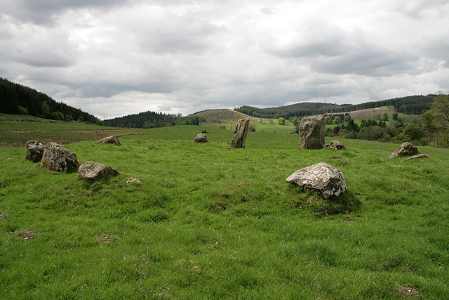
Hillside below Bught Knowe The plantation to the right flanks Bught Sike.
Hillside below Bught Knowe Credit: Oliver Dixon

Grey Hill is a prominent hill located in Dumfriesshire, Scotland. Rising to an elevation of approximately 355 meters (1,165 feet), it is a notable feature within the local landscape. Situated in the southern part of the region, Grey Hill offers breathtaking panoramic views of the surrounding countryside.

The hill is characterized by its gently sloping sides, covered in heather and grasses, which provide an ideal habitat for a variety of wildlife. It is also home to several species of birds, including pheasants and kestrels, making it a popular spot for birdwatchers. Additionally, the hill boasts a diverse range of plant life, with an array of wildflowers and ferns adorning its slopes.

Grey Hill is easily accessible to both hikers and nature enthusiasts, with a well-maintained footpath leading to its summit. The climb is of moderate difficulty, making it suitable for individuals of varying fitness levels. As visitors ascend, they are treated to ever-expanding vistas, taking in the rolling hills, lush valleys, and distant mountains that define the Dumfriesshire countryside.

The hill serves as an excellent location for outdoor activities such as picnicking, photography, and nature walks. Its peaceful ambiance and natural beauty make it an ideal setting for those seeking tranquility and an escape from the hustle and bustle of daily life. Whether one is a seasoned hillwalker or simply looking for a serene retreat, Grey Hill offers a memorable experience in Dumfriesshire's stunning landscape.

If you have any feedback on the listing, please let us know in the comments section below.

Grey Hill Images

Images are sourced within 2km of 55.245318/-3.0752447 or Grid Reference NY3195. Thanks to Geograph Open Source API. All images are credited.

Hillside below Bught Knowe The plantation to the right flanks Bught Sike.
Hillside below Bught Knowe
The plantation to the right flanks Bught Sike.
The Meggat Water Looking upstream towards Megdale. The road is the cul-de-sac road to Glendinning.
The Meggat Water
Looking upstream towards Megdale. The road is the cul-de-sac road to Glendinning.
Bridges over the Meggat Water at Megdale The further bridge is a Bailey bridge leading to Megdale Farm. The nearer bridge is a highly unsafe footbridge (see <a href="https://www.geograph.org.uk/photo/4607383">NY3095 : Dilapidated footbridge at Megdale</a>).
Bridges over the Meggat Water at Megdale
The further bridge is a Bailey bridge leading to Megdale Farm. The nearer bridge is a highly unsafe footbridge (see NY3095 : Dilapidated footbridge at Megdale).
Dilapidated footbridge at Megdale Surprisingly, access to this footbridge has not been blocked off, but it would be foolhardy indeed to attempt to cross the Meggat Water here, especially as there is a perfectly good Bailey bridge nearby.
Dilapidated footbridge at Megdale
Surprisingly, access to this footbridge has not been blocked off, but it would be foolhardy indeed to attempt to cross the Meggat Water here, especially as there is a perfectly good Bailey bridge nearby.
Megdale Farm On the far side of the Meggat Water from the cul de sac road up to Glendinning. Crossing the stream by the footbridge in view is very definitely not recommended (see <a href="https://www.geograph.org.uk/photo/4607383">NY3095 : Dilapidated footbridge at Megdale</a>).
Megdale Farm
On the far side of the Meggat Water from the cul de sac road up to Glendinning. Crossing the stream by the footbridge in view is very definitely not recommended (see NY3095 : Dilapidated footbridge at Megdale).
Sheep near Megdale Old School In a field corner at the edge of the square.
Sheep near Megdale Old School
In a field corner at the edge of the square.
Schoolhouse, Jamestown Built in the late 18th century for the children of the antimony miners at Jamestown. A school was considered very important.
Now undergoing renovation as holiday accommodation.
Schoolhouse, Jamestown
Built in the late 18th century for the children of the antimony miners at Jamestown. A school was considered very important. Now undergoing renovation as holiday accommodation.
Meggat Water View downstream from near the school house.
Meggat Water
View downstream from near the school house.
The Meggat Water south of Megdale Alkin Hill is in the background.
The Meggat Water south of Megdale
Alkin Hill is in the background.
Hill pasture A field on the lower southwest slopes of Alkin Hill with rough grazing and bracken higher up.
Hill pasture
A field on the lower southwest slopes of Alkin Hill with rough grazing and bracken higher up.
A house at Megdale Viewed from the single track road to Glendinning.
A house at Megdale
Viewed from the single track road to Glendinning.
Upper Stennieswater The ruined building at Upper Stennieswater.
Upper Stennieswater
The ruined building at Upper Stennieswater.
Forestry to the north of Upper Stennieswater
Under Stennieswater Looking along the track to Under Stennieswater with the Stennies Water on the right.
Under Stennieswater
Looking along the track to Under Stennieswater with the Stennies Water on the right.
Access track and gate On the route between Under Stennieswater and Crooks.
Access track and gate
On the route between Under Stennieswater and Crooks.
Hoggle Rig Looking over the head of Whitegill Sike to Hoggle Rig from Glenkeil Hill. Grey Hill is in the distance to the far right.
Hoggle Rig
Looking over the head of Whitegill Sike to Hoggle Rig from Glenkeil Hill. Grey Hill is in the distance to the far right.
A grass track on Grey Hill Munshiel Hill is in the distance to the left.
A grass track on Grey Hill
Munshiel Hill is in the distance to the left.
Munshiel Hill Looking from a fence on Munshiel Hill towards Grey Hill. There are two Grey Hills in this area, one to the north (401m) and one to the south (367m) of Munshiel Hill.
Munshiel Hill
Looking from a fence on Munshiel Hill towards Grey Hill. There are two Grey Hills in this area, one to the north (401m) and one to the south (367m) of Munshiel Hill.
Show me another place!

Grey Hill is located at Grid Ref: NY3195 (Lat: 55.245318, Lng: -3.0752447)

Unitary Authority: Dumfries and Galloway

Police Authority: Dumfries and Galloway

What 3 Words

///committed.vote.boater. Near Bentpath, Dumfries & Galloway

Nearby Locations

Grey Hill Munshiel Hill

Related Wikis

Bentpath

Bentpath is a small village between Eskdalemuir and Langholm in Dumfries and Galloway, Scotland. It is located on the River Esk and has a church and a...

Loupin Stanes

The Loupin Stanes (grid reference NY25709663) is a stone circle near Eskdalemuir, Dumfries and Galloway. Oval in shape, it consists of twelve stones set...

Eskdale (Scotland)

Eskdale (Scottish Gaelic: Eisgeadal, IPA:[ˈeʃkʲət̪əɫ̪]) is a glen and former lordship in the county of Dumfriesshire, Scotland. The River Esk flows through...

Girdle Stanes

The Girdle Stanes (grid reference NY 25351 96153) is a stone circle near Eskdalemuir, Dumfries and Galloway. The western portion of the circle has been...

Nearby Amenities

Located within 500m of 55.245318,-3.0752447
Gray Hill
Corbett: no
Ele: 367
Graham: no
Munro: no
Natural: peak
Lat/Long: 55.2435624/-3.0751681
The data included in this document is from www.openstreetmap.org. The data is made available under ODbL.

Have you been to Grey Hill?

Leave your review of Grey Hill below (or comments, questions and feedback).