Mey Hill

Hill, Mountain in Caithness

Scotland

Mey Hill

Ploughed field, Long Goe Farm Long Goe Farm with the Pentland Firth and Hoy in the distance.
Ploughed field, Long Goe Farm Credit: Paul E Smith

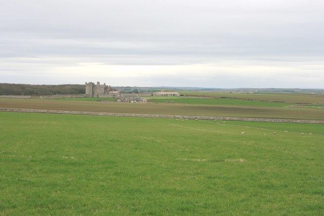
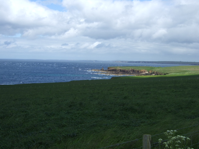
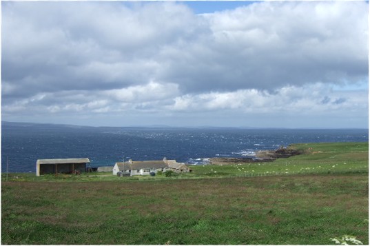
Mey Hill, located in Caithness, Scotland, is a prominent hill that offers breathtaking views and a rich historical significance. Standing at an elevation of approximately 137 meters (449 feet), it is not classified as a mountain but rather a hill. The area surrounding Mey Hill is known for its rugged and beautiful landscape, with rolling hills, vast moorlands, and the nearby North Sea.

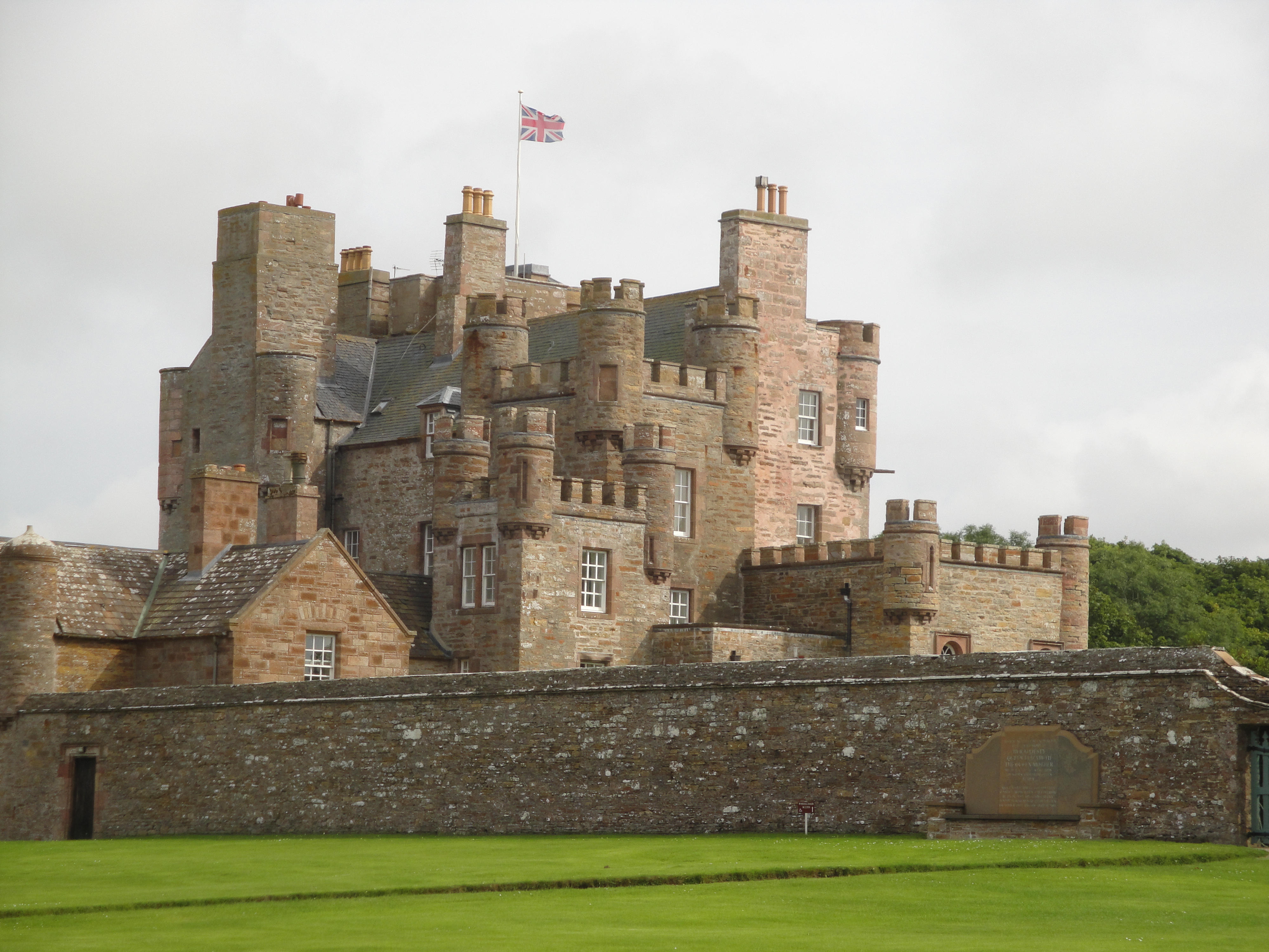
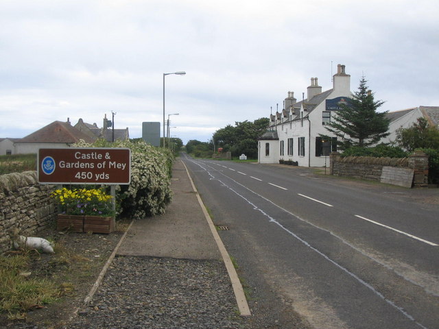
One of the most notable features of Mey Hill is its association with the historic Mey Castle, which is perched atop the hill. This 16th-century tower house was once the property of the powerful Sinclair family and is now privately owned by the Royal Family. The castle, with its distinctive architecture, adds to the charm and allure of the area.

Visitors to Mey Hill can enjoy a pleasant walk to the summit, where they are rewarded with panoramic views of the surrounding countryside, including nearby Thurso Bay and the Orkney Islands on a clear day. The hill is a popular spot for hikers and nature enthusiasts, offering ample opportunities to spot wildlife such as red deer, birds of prey, and various species of wildflowers.

Mey Hill is easily accessible by road, located just off the A836 near the village of Mey. It is approximately 18 kilometers (11 miles) east of Thurso, making it a convenient destination for those exploring the Caithness region. Whether for its historical significance, picturesque views, or outdoor activities, Mey Hill offers a captivating experience for visitors of all ages.

If you have any feedback on the listing, please let us know in the comments section below.
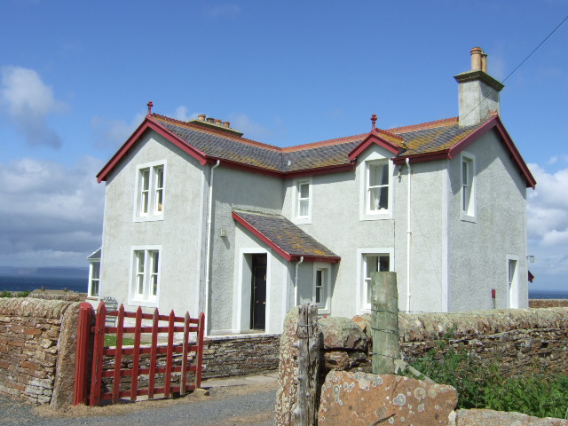
Mey Hill Images

Images are sourced within 2km of 58.648605/-3.1860074 or Grid Reference ND3174. Thanks to Geograph Open Source API. All images are credited.

Ploughed field, Long Goe Farm Long Goe Farm with the Pentland Firth and Hoy in the distance.
Ploughed field, Long Goe Farm
Long Goe Farm with the Pentland Firth and Hoy in the distance.
Pastureland near the Castle of Mey Looking across fields towards the Castle of Mey.
Pastureland near the Castle of Mey
Looking across fields towards the Castle of Mey.
Castle of Mey The Castle of Mey, in Caithness was the residence of the Queen Mother when she visited the county.  The Castle is now open to the public see more here:  <span class="nowrap"><a title="http://www.castleofmey.org.uk/" rel="nofollow ugc noopener" href="http://www.castleofmey.org.uk/">Link</a><img style="margin-left:2px;" alt="External link" title="External link - shift click to open in new window" src="https://s1.geograph.org.uk/img/external.png" width="10" height="10"/></span>
Castle of Mey
The Castle of Mey, in Caithness was the residence of the Queen Mother when she visited the county. The Castle is now open to the public see more here: LinkExternal link
Gill's Bay The Ferry Terminal on the North coast to St Margaret's Hope on Orkney
Gill's Bay
The Ferry Terminal on the North coast to St Margaret's Hope on Orkney
Gill's Bay Ferry Terminal The vehicle ferry to South Ronaldsay leaves here every hour.
Gill's Bay Ferry Terminal
The vehicle ferry to South Ronaldsay leaves here every hour.
Barrogill Mains With Castle of Mey, Mey Bay and Tang Head beyond.
Barrogill Mains
With Castle of Mey, Mey Bay and Tang Head beyond.
Barrogill Mains and Castle of Mey
East Lodge Castle of Mey.
East Lodge
Castle of Mey.
Access to Castle of Mey From East Lodge, on Barrock road.
Access to Castle of Mey
From East Lodge, on Barrock road.
Approach to junction on A836 From East Lodge to the A836 between Mey and East Mey.
Approach to junction on A836
From East Lodge to the A836 between Mey and East Mey.
Barrogill Mains farm
Tigh na Mara
Tigh na Mara
Approach to Seaview House Overlooking the Pentland Firth towards Hoy.
Approach to Seaview House
Overlooking the Pentland Firth towards Hoy.
Seaview House
Seaview House
Long Goe Farm Close to Longgeo - a more conventional spelling.
Long Goe Farm
Close to Longgeo - a more conventional spelling.
Track to Long Goe farm On the shore of the Pentland Firth.
Track to Long Goe farm
On the shore of the Pentland Firth.
View towards Men of Mey and st John's Point The Tower of Mey (Stack) can just be discerned.
View towards Men of Mey and st John's Point
The Tower of Mey (Stack) can just be discerned.
Maligoe Near St John's Point, by the Pentland Firth.
Maligoe
Near St John's Point, by the Pentland Firth.
Show me another place!

Mey Hill is located at Grid Ref: ND3174 (Lat: 58.648605, Lng: -3.1860074)

Unitary Authority: Highland

Police Authority: Highlands and Islands

What 3 Words

///tolerable.physics.investor. Near John o' Groats, Highland

Related Wikis

East Mey

East Mey is a scattered crofting village in northern Caithness, Scottish Highlands and is in the Scottish council area of Highland. == References ==

Gills, Caithness

Galltair is a remote coastal, scattered crofting township and former fishing village, on the north coast of Caithness, Scottish Highlands, in the Scottish...

Gills Bay

Gills Bay, which is situated about 3 mi (4.8 km) west of John o' Groats with the community of Gills close by, has one of the longest stretches of low-lying...

Castle of Mey

The Castle of Mey (also known for a time as Barrogill Castle) is located in Caithness, on the north coast of Scotland, about 6 miles (10 km) west of John...

Mey, Highland

Mey is a remote village, located on the north coast of Scotland in Caithness, Scottish Highlands and is in the Scottish council area of Highland.Mey lies...

Harrow, Caithness

Harrow is a hamlet on the north coast of Caithness, Scotland. It lies just to the west of the Castle of Mey and northeast of the Loch of Mey. Harrow Harbour...

Canisbay Parish Church

Canisbay Parish Church is a Church of Scotland church in Canisbay, Scotland, that dates back to the early 1600s and is the most northernly church on mainland...

MeyGen

MeyGen (full name MeyGen tidal energy project) will be the world's largest tidal energy plant, which is currently in construction. The first phase of the...

Nearby Amenities

Located within 500m of 58.648605,-3.1860074
Source: PGS
Lat/Long: 58.6504934/-3.1782084
Source: PGS
Lat/Long: 58.6504655/-3.1785303
Source: PGS
Lat/Long: 58.6507111/-3.1791311
Source: PGS
Lat/Long: 58.6510237/-3.1793886
Source: PGS
Lat/Long: 58.6512693/-3.1795603
Source: PGS
Lat/Long: 58.6514925/-3.1796032
Cafe
Tea Cosy
Lat/Long: 58.6521772/-3.1893326
Power: pole
Lat/Long: 58.6459571/-3.1925347
Power: pole
Lat/Long: 58.6455535/-3.1914972
Power: pole
Lat/Long: 58.6451193/-3.1904698
Power: pole
Lat/Long: 58.6446534/-3.1892922
Power: pole
Lat/Long: 58.6442921/-3.1884069
Power: pole
Lat/Long: 58.6442308/-3.1844781
Power: pole
Lat/Long: 58.6446228/-3.1851461
Power: pole
Lat/Long: 58.6449165/-3.1856801
Power: pole
Lat/Long: 58.6452281/-3.1862588
Power: pole
Lat/Long: 58.6480594/-3.1937651
Power: pole
Lat/Long: 58.6481809/-3.1935296
Power: pole
Lat/Long: 58.6487767/-3.1925144
Power: pole
Lat/Long: 58.6491264/-3.1919256
Power: pole
Lat/Long: 58.6496397/-3.1910668
Power: pole
Lat/Long: 58.6502524/-3.1900191
Power: pole
Lat/Long: 58.6508767/-3.1890018
Power: pole
Lat/Long: 58.6512263/-3.1883887
Power: pole
Lat/Long: 58.652064/-3.188411
Power: pole
Lat/Long: 58.6523999/-3.1884313
Power: pole
Lat/Long: 58.6524168/-3.1891866
Power: pole
Lat/Long: 58.6524421/-3.190078
The data included in this document is from www.openstreetmap.org. The data is made available under ODbL.

Have you been to Mey Hill?

Leave your review of Mey Hill below (or comments, questions and feedback).