Knott

Hill, Mountain in Cumberland Allerdale

England

Knott

On Cumbria Way - Lingy Hut (bothy) on Great Lingy Hill
On Cumbria Way - Lingy Hut (bothy) on Great Lingy Hill Credit: Colin Park

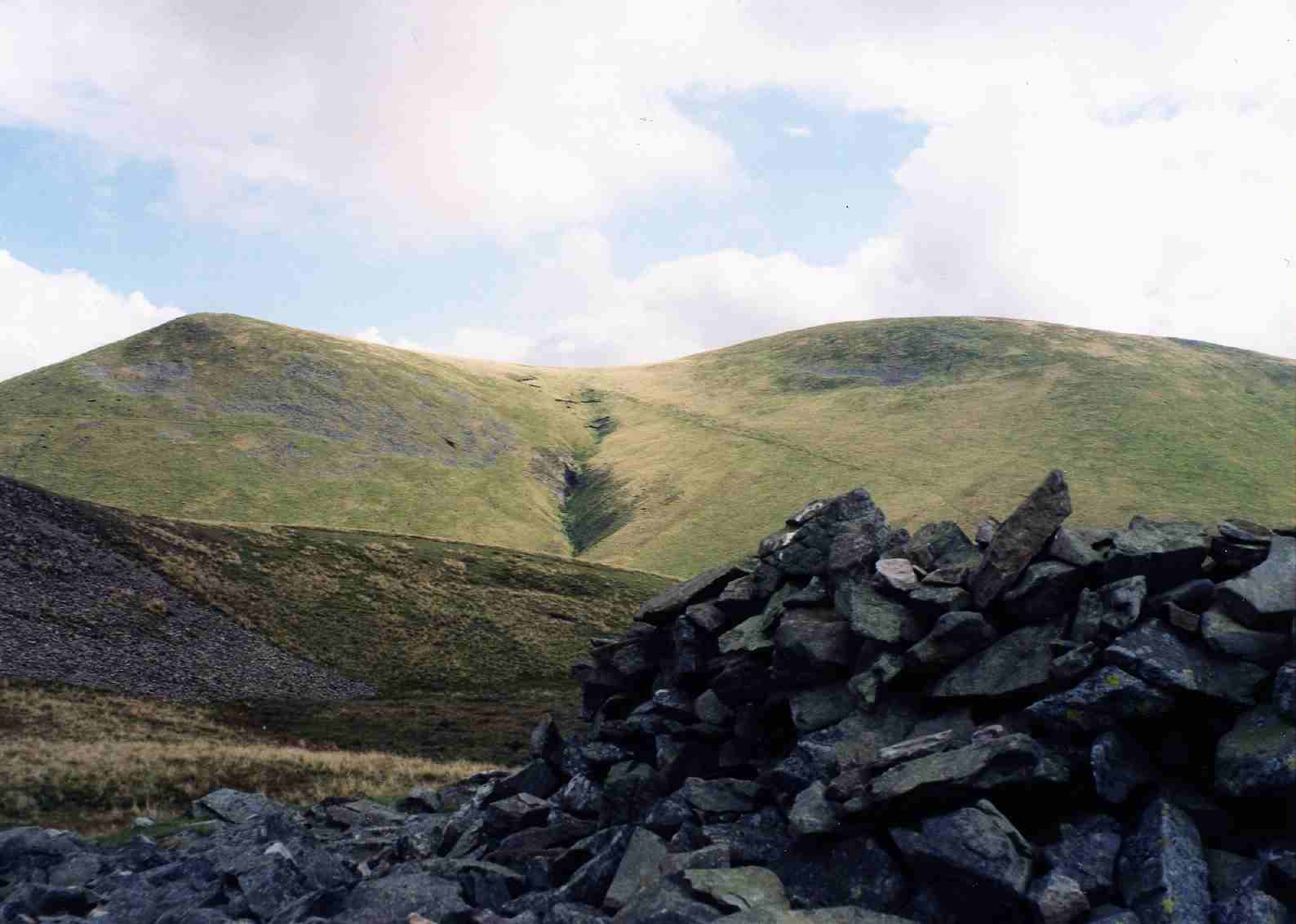
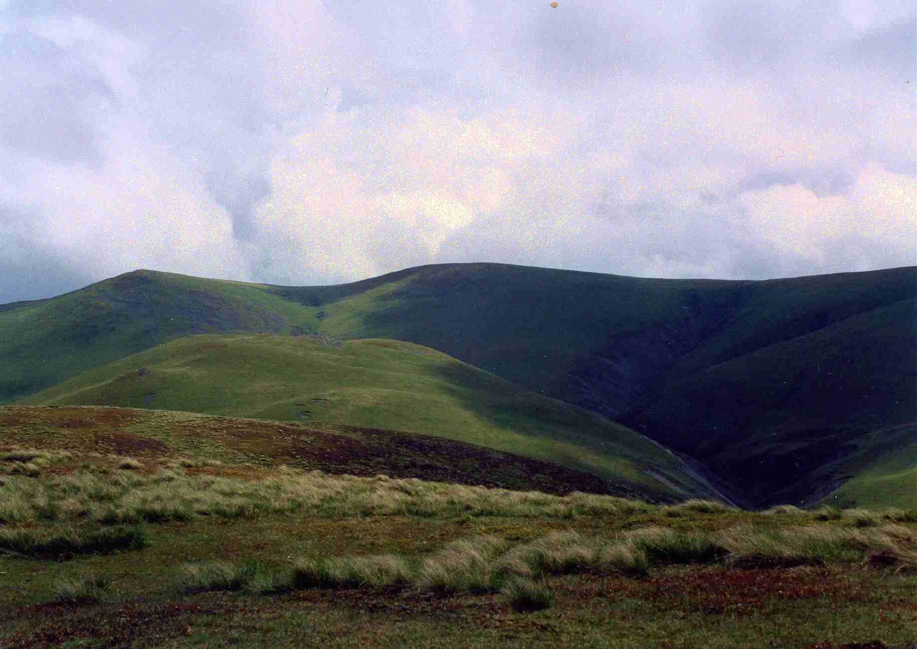
Knott is a prominent hill located in the county of Cumberland in the Lake District National Park in Cumbria, England. It is situated near the town of Keswick and stands at an elevation of 710 meters (2,329 feet) above sea level. Knott is known for its distinctive shape, with a steep and rocky summit that offers panoramic views of the surrounding countryside.

The hill is a popular destination for hikers and outdoor enthusiasts, with several walking routes leading to the summit. The ascent to the top of Knott can be challenging, but the reward of reaching the peak and taking in the breathtaking scenery makes it well worth the effort.

Knott is also home to a variety of wildlife, including birds of prey such as buzzards and kestrels, as well as sheep and other grazing animals. The hill is part of the Caldbeck Fells, a range of hills and mountains in the northern Lake District known for their rugged beauty and remote wilderness.

Overall, Knott is a beautiful and rewarding destination for those looking to explore the natural beauty of the Lake District and enjoy a challenging hike to a stunning summit.

If you have any feedback on the listing, please let us know in the comments section below.

Knott Images

Images are sourced within 2km of 54.68699/-3.0933322 or Grid Reference NY2932. Thanks to Geograph Open Source API. All images are credited.

On Cumbria Way - Lingy Hut (bothy) on Great Lingy Hill
Trusmadoor A miserable day. Penetrating drizzle with visibility limited to a few metres. I guess this col on the Great Cockup ridge was formed from the action of glacial meltwater.
Trusmadoor
A miserable day. Penetrating drizzle with visibility limited to a few metres. I guess this col on the Great Cockup ridge was formed from the action of glacial meltwater.
Short grass near summit of Knott Knott is a hill at the heart of the Lake District's Northern Fells. High Pike and Carrock Fell are the two peaks in view beyond the grassed area which is just east of the hill's summit.
Short grass near summit of Knott
Knott is a hill at the heart of the Lake District's Northern Fells. High Pike and Carrock Fell are the two peaks in view beyond the grassed area which is just east of the hill's summit.
View from Little Sca Fell
View from Great Sca Fell
Towards Meal Fell
Towards Meal Fell
Great Cockup
Great Cockup
Near the summit of Knott Looking south through the upper Glenderaterra valley. The hills in the middle distance are (left to right) the long ridge of Blencathra, Lonscale Fell, and the start of the climb to Skiddaw. Rather nearer, in front of Lonscale Fell, is Great Calva, from where you get an even better view of the central rift in the Lake District, through Thirlmere and beyond.
Near the summit of Knott
Looking south through the upper Glenderaterra valley. The hills in the middle distance are (left to right) the long ridge of Blencathra, Lonscale Fell, and the start of the climb to Skiddaw. Rather nearer, in front of Lonscale Fell, is Great Calva, from where you get an even better view of the central rift in the Lake District, through Thirlmere and beyond.
The view to High Pike from Knott
View from the summit of Great Cockup Looking east towards Burn Tod to the right, Meal Fell to the left with the ridge of Great Sca Fell and Knott in the distance .
View from the summit of Great Cockup
Looking east towards Burn Tod to the right, Meal Fell to the left with the ridge of Great Sca Fell and Knott in the distance .
On Burn Tod Looking east towards Knott.
On Burn Tod
Looking east towards Knott.
View north from Meal Fell From the grassy top of the fell looking over Lothwaite and Longlands fells.
View north from Meal Fell
From the grassy top of the fell looking over Lothwaite and Longlands fells.
View south from  the summit of Knott With great Calva to the left and Skiddaw ahead.
View south from the summit of Knott
With great Calva to the left and Skiddaw ahead.
Cairn on Great Sca Fell
View over Yard Steel Looking over the Cumbrian Plain beyond.
View over Yard Steel
Looking over the Cumbrian Plain beyond.
Trusmadoor from Frozen Fell Looking down on that distinct cleft of Trusmadoor in the Great Cockup/Meal fell ridge. Wainwright wrote of it:

"Nobody ever sung the praises of Trusmadoor, and it’s time someone did. This lonely passage between the hills, an obvious and easy way for man and beast and beloved by wheeling buzzards and hawks, has a strange nostalgic charm. Its neat and regular proportions are remarkable — a natural `railway cutting’. What a place for an ambush and a massacre!"

Lovely. What more can I say? Great Cockup on the left and in the distance is Binsey, perhaps the most isolated fell in the Lake District. The tarn in the middle distance is Over Water.

From my blog <span class="nowrap"><a title="http://www.fhithich.uk/?p=20393" rel="nofollow ugc noopener" href="http://www.fhithich.uk/?p=20393">Link</a><img style="margin-left:2px;" alt="External link" title="External link - shift click to open in new window" src="https://s1.geograph.org.uk/img/external.png" width="10" height="10"/></span>
Trusmadoor from Frozen Fell
Looking down on that distinct cleft of Trusmadoor in the Great Cockup/Meal fell ridge. Wainwright wrote of it: "Nobody ever sung the praises of Trusmadoor, and it’s time someone did. This lonely passage between the hills, an obvious and easy way for man and beast and beloved by wheeling buzzards and hawks, has a strange nostalgic charm. Its neat and regular proportions are remarkable — a natural `railway cutting’. What a place for an ambush and a massacre!" Lovely. What more can I say? Great Cockup on the left and in the distance is Binsey, perhaps the most isolated fell in the Lake District. The tarn in the middle distance is Over Water. From my blog LinkExternal link
Southern slopes of Knott View towards Blencathra (background) and Great Calva - pointy.
Southern slopes of Knott
View towards Blencathra (background) and Great Calva - pointy.
Track between the Sca Fells The map clearly shows a public bridleway across the undulating plateau of Little and Great Sca Fells, but, having ascended from Charleton Gill, it visits neither summit and disappears without obvious destination on the col to the south. It does not seem to exist on the ground. The visible track does not appear on the map at all, despite seeming to have a logic and purpose for walkers. However, this too rather evaporates south of Great Sca Fell, leaving only a vague route for those continuing on their way to visit Knott, the highest point in the group. Although by no means as high as the better-known central fells, the position of these hills on the edge of the uplands affords them splendid views over the Solway to the north.
Track between the Sca Fells
The map clearly shows a public bridleway across the undulating plateau of Little and Great Sca Fells, but, having ascended from Charleton Gill, it visits neither summit and disappears without obvious destination on the col to the south. It does not seem to exist on the ground. The visible track does not appear on the map at all, despite seeming to have a logic and purpose for walkers. However, this too rather evaporates south of Great Sca Fell, leaving only a vague route for those continuing on their way to visit Knott, the highest point in the group. Although by no means as high as the better-known central fells, the position of these hills on the edge of the uplands affords them splendid views over the Solway to the north.
Show me another place!

Knott is located at Grid Ref: NY2932 (Lat: 54.68699, Lng: -3.0933322)

Administrative County: Cumbria

District: Allerdale

Police Authority: Cumbria

What 3 Words

///activity.cross.workbench. Near Keswick, Cumbria

Nearby Locations

Knott

Related Wikis

Knott, Caldbeck

Knott is a mountain in the northern part of the English Lake District. It is the highest point of the Back o'Skiddaw region, an area of wild and unfrequented...

Great Sca Fell

Great Sca Fell is a fell in the English Lake District, seven kilometres (4+1⁄2 miles) southwest of the village of Caldbeck. It is the highest of the four...

Skiddaw Group

For the Skiddaw group of hills, see Skiddaw Group The Skiddaw Group is a group of sedimentary rock formations named after the mountain Skiddaw in the English...

Meal Fell

Meal Fell is a small fell in the northern region of the English Lake District, it is situated seven kilometres (4+1⁄4 miles) south-west of the village...

Nearby Amenities

Located within 500m of 54.68699,-3.0933322
Knott
Ele: 710
Natural: peak
Source: npe;https://www.hill-bagging.co.uk/mountaindetails.php?qu=S&rf=2328
Wikidata: Q6423088
Wikipedia: en:Knott
Lat/Long: 54.6869821/-3.0932813
Man Made: cairn
Lat/Long: 54.6869778/-3.0933042
The data included in this document is from www.openstreetmap.org. The data is made available under ODbL.

Have you been to Knott?

Leave your review of Knott below (or comments, questions and feedback).