Fair Hope Hill

Hill, Mountain in Peeblesshire

Scotland

Fair Hope Hill

Track at eastern end of Bowbeat Wind Farm - view to Blackhope Scar
Track at eastern end of Bowbeat Wind Farm - view to Blackhope Scar Credit: Colin Park

Fair Hope Hill is a prominent hill located in the Peeblesshire region of Scotland. Rising to an elevation of approximately 430 meters (1,410 feet), it is part of the picturesque Scottish Borders and stands as a remarkable natural feature in the area. The hill is characterized by its gentle slopes and lush greenery, offering a stunning panoramic view of the surrounding countryside.

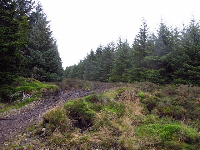
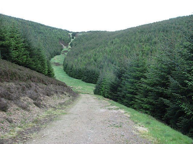
Situated near the village of Eddleston, Fair Hope Hill attracts visitors with its scenic beauty and tranquil atmosphere. The hill is a popular destination for hikers and nature enthusiasts, offering a variety of walking trails that cater to different skill levels. The paths wind through heather-clad slopes and ancient woodlands, providing an opportunity to explore the diverse flora and fauna of the region.

At the summit of Fair Hope Hill, visitors are rewarded with breathtaking vistas of the rolling hills and valleys of Peeblesshire. On a clear day, the views extend as far as the Southern Uplands and the distant peaks of the Scottish Highlands. The hill also boasts several viewpoints along its trails, where visitors can pause and admire the stunning landscapes.

Fair Hope Hill is not only a haven for outdoor enthusiasts but also holds historical significance. It is believed to have been a site of ancient settlements, with remnants of Iron Age hill forts and stone circles found in the vicinity. The hill's rich history adds to its allure, captivating those with an interest in archaeology and the region's past.

Overall, Fair Hope Hill is a natural treasure in Peeblesshire, offering a combination of scenic beauty, recreational opportunities, and a glimpse into Scotland's ancient history. Whether one seeks a challenging hike or a peaceful stroll in nature, this hill provides an unforgettable experience for all who visit.

If you have any feedback on the listing, please let us know in the comments section below.

Fair Hope Hill Images

Images are sourced within 2km of 55.704145/-3.1301569 or Grid Reference NT2946. Thanks to Geograph Open Source API. All images are credited.

Track at eastern end of Bowbeat Wind Farm - view to Blackhope Scar
Logging road, Long Grain A forest road below Bowbeat Hill and within earshot of the wind turbines. The road is showing signs of recent use, there is a  big clear fell area nearby.
Logging road, Long Grain
A forest road below Bowbeat Hill and within earshot of the wind turbines. The road is showing signs of recent use, there is a big clear fell area nearby.
Middle Rig A ride through dense woodland is used as an access route to the moorland by a local estate.
Middle Rig
A ride through dense woodland is used as an access route to the moorland by a local estate.
Forest road, Leithen Water This road has been recently upgraded. Much of the forest is ready for felling and a lot of timber will be carried out.
Forest road, Leithen Water
This road has been recently upgraded. Much of the forest is ready for felling and a lot of timber will be carried out.
Forest track, Totto Hill The track gradually gains height on the west-facing slopes above the Leithen Water.
Forest track, Totto Hill
The track gradually gains height on the west-facing slopes above the Leithen Water.
Foxgloves by the track A touch of colour by the forest track around Totto Hill, Leithenwater Forest. Some of the Bowbeat windfarm turbines are on the skyline.
Foxgloves by the track
A touch of colour by the forest track around Totto Hill, Leithenwater Forest. Some of the Bowbeat windfarm turbines are on the skyline.
Forestry patterns, Leithenwater Forest Looking across the Leithen Water valley from Totto Hill to Lamb Law.
Forestry patterns, Leithenwater Forest
Looking across the Leithen Water valley from Totto Hill to Lamb Law.
Bowbeat windfarm from Leithenwater Forest Some of the 24 turbines comprising the 31MW Bowbeat windfarm, which began generating in 2002.
Bowbeat windfarm from Leithenwater Forest
Some of the 24 turbines comprising the 31MW Bowbeat windfarm, which began generating in 2002.
Forest track, Cape Hill In Leithenwater Forest above Craig Hope with some of the Bowbeat turbines on the skyline. The slope below the track has been replanted.
Forest track, Cape Hill
In Leithenwater Forest above Craig Hope with some of the Bowbeat turbines on the skyline. The slope below the track has been replanted.
Murder Cleuch I wonder what event gave rise to this name - an otherwise unremarkable feature in Leithenwater Forest, the burn draining to Craig Hope Burn.
Murder Cleuch
I wonder what event gave rise to this name - an otherwise unremarkable feature in Leithenwater Forest, the burn draining to Craig Hope Burn.
Standing tree, Craig Hope A few trees are left standing in clear felling as part of the 'deadwood' that is beneficial to nutrient cycling and biodiversity in the growing forest. More information can be found in the publication 'Managing Deadwood in Forests and Woodlands', Forestry Commission at <span class="nowrap"><a title="https://www.forestry.gov.uk/england-managingdeadwood" rel="nofollow ugc noopener" href="https://www.forestry.gov.uk/england-managingdeadwood">Link</a><img style="margin-left:2px;" alt="External link" title="External link - shift click to open in new window" src="https://s1.geograph.org.uk/img/external.png" width="10" height="10"/></span>.
Standing tree, Craig Hope
A few trees are left standing in clear felling as part of the 'deadwood' that is beneficial to nutrient cycling and biodiversity in the growing forest. More information can be found in the publication 'Managing Deadwood in Forests and Woodlands', Forestry Commission at LinkExternal link.
Track at east end of Bowbeat Wind Farm Looking towards the fence and track on Long Edge
Track at east end of Bowbeat Wind Farm
Looking towards the fence and track on Long Edge
Bowbeat Wind Farm Notice board on the approach to the Bowbeat Wind Farm on the approach from Blackhope Scar.
Bowbeat Wind Farm
Notice board on the approach to the Bowbeat Wind Farm on the approach from Blackhope Scar.
Leithenwater Forest track
Craig Hope Looking down the track in Leithenwater Forest.
Craig Hope
Looking down the track in Leithenwater Forest.
Eastern end of Bowbeat wind farm This turbine has been brought to a halt by rotating the blade tips, which quickly slows down the rotation. The turbines are controlled remotely via a data link.
Eastern end of Bowbeat wind farm
This turbine has been brought to a halt by rotating the blade tips, which quickly slows down the rotation. The turbines are controlled remotely via a data link.
Notice, Bowbeat wind farm At least access on foot is not prohibited, so a few words of caution are given alongside the map.
Notice, Bowbeat wind farm
At least access on foot is not prohibited, so a few words of caution are given alongside the map.
Forest road, Soonhope The upper reaches of the Soonhope Burn, clothed in a first generation Sitka spruce plantation.
Forest road, Soonhope
The upper reaches of the Soonhope Burn, clothed in a first generation Sitka spruce plantation.
Show me another place!

Fair Hope Hill is located at Grid Ref: NT2946 (Lat: 55.704145, Lng: -3.1301569)

Unitary Authority: The Scottish Borders

Police Authority: The Lothians and Scottish Borders

What 3 Words

///mouths.donates.prefix. Near Peebles, Scottish Borders

Related Wikis

Bowbeat Hill

Bowbeat Hill is a hill in the Moorfoot Hills range, part of the Southern Uplands of Scotland. It lends its name to Bowbeat Onshore Wind Farm built on the...

Glentress Forest

Glentress Forest is located near Peebles in the Scottish Borders, about 30 miles south of Edinburgh. Part of the Tweed Valley Forest Park along with Traquair...

Blackhope Scar

Blackhope Scar is a hill in the Moorfoot Hills range, part of the Southern Uplands of Scotland. It lies to the northeast of the town of Peebles and is...

Milkieston Rings

Milkieston Rings is a prehistoric site, a hillfort near the village of Eddleston and about 3 miles (5 km) north of Peebles, in the Scottish Borders, Scotland...

Nearby Amenities

Located within 500m of 55.704145,-3.1301569
Generator Method: wind_turbine
Generator Output Electricity: yes
Generator Source: wind
Generator Type: horizontal_axis
Power: generator
Source: Bing
Lat/Long: 55.7084967/-3.1310991
The data included in this document is from www.openstreetmap.org. The data is made available under ODbL.

Have you been to Fair Hope Hill?

Leave your review of Fair Hope Hill below (or comments, questions and feedback).