Hill of Strone

Hill, Mountain in Angus

Scotland

Hill of Strone

Trig and cairn on Driesh
Trig and cairn on Driesh Credit: Steven Brown

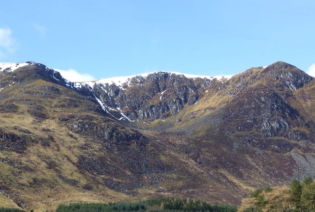
Located in Angus, Scotland, Hill of Strone is a prominent hill or small mountain that stands at an elevation of approximately 471 meters (1,545 feet) above sea level. It is situated within the eastern Highlands region, specifically in the southern part of the Grampian Mountains. Hill of Strone is known for its picturesque landscape and offers breathtaking views of the surrounding countryside.

This hill is characterized by its gently sloping grassy slopes, which are interspersed with patches of heather and scattered rocks. The terrain is typically rugged, with some steep areas towards the summit. The hill is accessible by various footpaths and trails, making it a popular destination for hikers and nature enthusiasts.

The summit of Hill of Strone provides panoramic views of the surrounding Angus countryside, including the River North Esk and the nearby towns and villages. On clear days, it is possible to see as far as the North Sea and the Cairngorms National Park. The hill also offers a tranquil and peaceful atmosphere, making it an ideal spot for relaxation and contemplation.

Due to its location within the Grampian Mountains, Hill of Strone experiences a typical Highland climate. This means that the weather can be unpredictable, with rain, mist, and strong winds being common occurrences. It is advisable for visitors to come prepared with appropriate clothing and equipment.

Overall, Hill of Strone offers a rewarding outdoor experience for those seeking to immerse themselves in the natural beauty of the Angus region in Scotland.

If you have any feedback on the listing, please let us know in the comments section below.

Hill of Strone Images

Images are sourced within 2km of 56.842185/-3.1684772 or Grid Reference NO2872. Thanks to Geograph Open Source API. All images are credited.

Trig and cairn on Driesh
Approaching summit of Driesh Flat summit area crowned by a stone shelter and trig pillar.
Approaching summit of Driesh
Flat summit area crowned by a stone shelter and trig pillar.
Summit of Driesh 947m A Munro defined as a mountain in Scotland with a height over 3,000 feet (914.4 m), and which is on the Scottish Mountaineering Club (SMC) official list of Munros; there is no explicit topographical prominence requirement.
Summit of Driesh 947m
A Munro defined as a mountain in Scotland with a height over 3,000 feet (914.4 m), and which is on the Scottish Mountaineering Club (SMC) official list of Munros; there is no explicit topographical prominence requirement.
Winter Corrie, Glen Clova With a little snow in the gullies and remnants of cornices.
Winter Corrie, Glen Clova
With a little snow in the gullies and remnants of cornices.
Driesh summit towards Glen Doll Forest
Driesh and Little Driesh Driesh is slightly behind the foreground ridge of Little Driesh but is actually the higher summit.
Driesh and Little Driesh
Driesh is slightly behind the foreground ridge of Little Driesh but is actually the higher summit.
Driesh Trig Point The enclosure gives a welcome shelter from the chill winds while having your lunch.
Driesh Trig Point
The enclosure gives a welcome shelter from the chill winds while having your lunch.
Shank of Driesh track The track heading northwards up the Shank of Driesh.
Shank of Driesh track
The track heading northwards up the Shank of Driesh.
Summit of Driesh Looking south-westwards to the trig pillar and stone shelter on the summit of Driesh.
Summit of Driesh
Looking south-westwards to the trig pillar and stone shelter on the summit of Driesh.
Plateau at Driesh summit
Plateau at Driesh summit with view towards Lochnagar
The flat summit of Driesh A Munro of 947m, Driesh has an unexciting flat and grassy summit. The long views are fine though.
The flat summit of Driesh
A Munro of 947m, Driesh has an unexciting flat and grassy summit. The long views are fine though.
Driesh Summit Trig point and shelter on Driesh summit, looking South.
Driesh Summit
Trig point and shelter on Driesh summit, looking South.
Lower slopes of a Munro The top of this escarpment seen from Glen Doll is the 947 metre peak of Dreish.
Lower slopes of a Munro
The top of this escarpment seen from Glen Doll is the 947 metre peak of Dreish.
Grassy northern slopes of Driesh Looking north from near the summit. From left to right, the most prominent hills are Lochnagar, then Tap o' Noth in the far distance, and Mount Keen about 15 miles away.
Grassy northern slopes of Driesh
Looking north from near the summit. From left to right, the most prominent hills are Lochnagar, then Tap o' Noth in the far distance, and Mount Keen about 15 miles away.
At the summit of Driesh The trig point sits within a small ring cairn-cum-windbreak - just high enough to keep the wind off your head when seated.
At the summit of Driesh
The trig point sits within a small ring cairn-cum-windbreak - just high enough to keep the wind off your head when seated.
Driesh Trig Point and Cairn A fine cairn surrounding the OS Trig Point. Mayar can be seen just to the right of the cairn.
Driesh Trig Point and Cairn
A fine cairn surrounding the OS Trig Point. Mayar can be seen just to the right of the cairn.
In Glenclova Forest The burn rather intriguingly known as 'Dead Water' flows from right to left through the dip ahead, joining the Burn of Farchal about 200 metres downstream.
In Glenclova Forest
The burn rather intriguingly known as 'Dead Water' flows from right to left through the dip ahead, joining the Burn of Farchal about 200 metres downstream.
Show me another place!

Hill of Strone is located at Grid Ref: NO2872 (Lat: 56.842185, Lng: -3.1684772)

Unitary Authority: Angus

Police Authority: Tayside

What 3 Words

///webcams.emerald.charging. Near Kirriemuir, Angus

Nearby Locations

Hill of Strone

Related Wikis

Driesh

Driesh (Gaelic: Dris) is a mountain located in the Grampians of Scotland. Apart from Mount Keen (939 m/3,080 ft), it is the most easterly of the Munro...

Clova, Angus

Clova is a village in Glen Clova, Angus, Scotland. It lies on the River South Esk, some 12 miles (19 km) north of Kirriemuir. During the 1745 Jacobite...

Glen Doll

Glen Doll, also sometimes spelt Glendoll, lies within the Cairngorms National Park, Scotland, at the top of Glen Clova, in an area of steep hills, corries...

Corrie Fee

Corrie Fee is a glacier-carved corrie situated at the head of Glen Clova in the Angus Glens of Scotland. It forms part of Corrie Fee National Nature Reserve...

Nearby Amenities

Located within 500m of 56.842185,-3.1684772
Hill of Strone
Ele: 846
Natural: peak
Lat/Long: 56.8420287/-3.1686078
Ashnamuck
Name Gd: Ais nam Muc
Place: locality
Lat/Long: 56.8383263/-3.1667846
The data included in this document is from www.openstreetmap.org. The data is made available under ODbL.

Have you been to Hill of Strone?

Leave your review of Hill of Strone below (or comments, questions and feedback).